Mountain region – Subpolar Urals Gorge – valley of the Balbanyu river Peak – Mount Karpinsky (1803) Route – via the northwestern ridge Category of difficulty – 3A cat. diff.
Climbing Passport
Region – Subpolar Urals. Mountain range – Issledovatelsky Ridge. Gorge – Valley of the Balbanyu river. Section number according to KMGV-2001 – 8. "Other mountain systems, massifs"
Name of the peak – Mount Karpinsky Height 1803 Route name – via the western ridge Category of difficulty: Proposed 3A cat. diff. Route type: rock climbing First ascent
Note: The Alpinism Federation of the Komi Republic requests that the group be credited with a 3B cat. diff. ascent.
Elevation gain – 1320 m.
Route length – 2200 m.
Sections of 5 cat. diff. – none, 6 cat. diff. – none.
Average steepness of the main (technical part) of the route – 60 °.
Average steepness of the entire route – 35 °.
Pitons left on the route – 3. Pitons used on the route – 5 rock pitons, 8 chockstones (stoppers and hexes).
Approach to the "Behind the All-Terrain Vehicle" bivouac – 1 day. Ascent from the "Behind the All-Terrain Vehicle" bivouac – 16 hours.
Leader: Zhuravlev Sergey Vasilyevich, CMS, instructor 2 cat.
Participants:
- P. Gayner – 3rd sports category (Syktyvkar)
- I. Ivonina – 3rd sports category (Syktyvkar)
- V. Toropov – 3rd sports category (Syktyvkar)
- A. Shershov – 3rd sports category (Syktyvkar)
Coach: Zhuravlev Sergey Vasilyevich, CMS, instructor 2 cat.
Departure on the route – 7:00, July 28, 2005. Reaching the summit – 16:00, July 28, 2005. Return to the base camp – 19:00, July 28, 2005.
Organization: Youth scientific and sports expedition of the Alpinism Federation of the Komi Republic and the Yugyd Va National Park – "Victory – 2005", July 15 – August 2, 2005.
Executor: Zhuravlev Sergey Vasilyevich, Syktyvkar, 167000, Internatsionalnaya st., 97, apt. 12, tel. 24–24–91, E-mail: Zhur58@rambler.ru. Coach – supervisor S. V. Zhuravlev
Peak – Mount Karpinsky (1803)
Mount Karpinsky, with a height of 1803 m above sea level, is the second highest peak in the Urals and the highest peak in the Komi Republic. It is located in the Issledovatelsky Ridge, on the border between Europe and Asia, between the mountain massifs of Mount Staruha (1439) and Mount Narodnaya (1895). Discovered in 1927. Named after the first president of the USSR Academy of Sciences A. P. Karpinsky (1847–1936).
Several routes lead to the summit of Mount Karpinsky, both from the west (from Europe) and from the east (from Asia).
A feature of all routes is that they are quite long (the duration of only the technical part of each route is more than 2000 m). The structure of the routes is stepped: short, complex rock walls alternate with long ridge sections. The elevation gain from the base camp is more than 1500 m.
Another common feature of all routes is the climate:
- From October 15 to May 25, the routes on Mount Karpinsky are combined.
- From May 25 to October 15 – rock climbing.
Karpinsky 1803
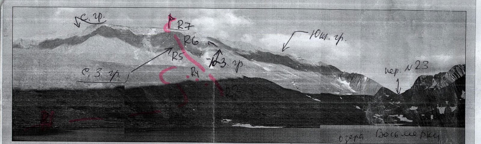
Profile of the western slope of Mount Karpinsky (1803)
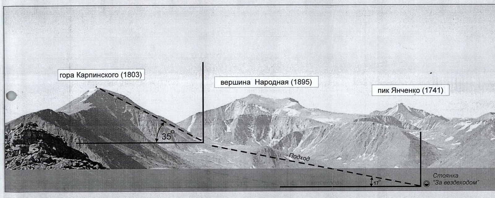
Several mountaineering routes are laid out along the counterforts of the western slope of Mount Karpinsky. The average steepness of these routes is 35 °. Nevertheless, one should take into account the rock-step structure of these routes, where each step of the ridge or counterfort is separated from the above ones by rock walls 15–40 m of varying steepness (from 15 ° on the ridge sections to 75 ° on the walls).
Routes via the counterforts of the western slope of Mount Karpinsky:
- are long;
- require the mandatory presence of camping equipment for the sports group.
The photo of the profile of the western slope of Mount Karpinsky was taken from the summit of Mount Staruha.
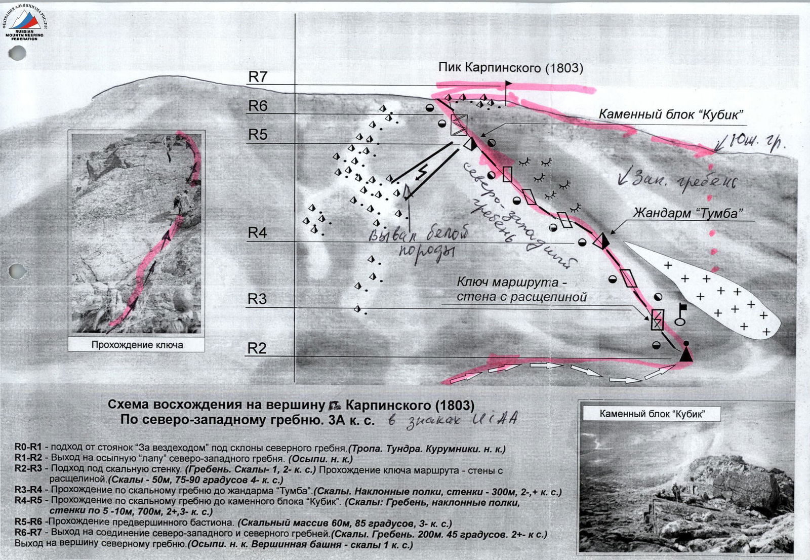
Ascent scheme to the summit of Karpinsky (1803)
Via the northwestern ridge. 3A cat. diff. in UIAA signs
R0–R1 – approach from the "Behind the All-Terrain Vehicle" campsite under the slopes of the northern ridge. (Trail. Tundra. Scree. n.c.) R1–R2 – exit to the scree "paw" of the northwestern ridge. (Scree. n.c.) R2–R3 – approach to the rock wall. (Ridge. Rocks – 1, 2.) Passage of the key section of the route – wall with a cleft. (Rocks – 50 m, 75–90 °, 4.) R3–R4 – passage along the rocky ridge to the "Tumba" gendarme. (Rocks. Inclined shelves, walls – 300 m, 2–3.) R4–R5 – passage along the rocky ridge to the "Kubik" rock block. (Rocks: Ridge, inclined shelves, walls 5–10 m, 700 m, 2–3.) R5–R6 – passage of the pre-summit bastion. (Rock massif 60 m, 85 °, 3.) R6–R7 – exit to the junction of the northwestern and northern ridges. (Rocks. Ridge. 200 m. 45 °, 2.) Exit to the summit via the northern ridge. (Scree. n.c. Summit tower – rocks 1.)
Description of the summit (OSV)
Mount Karpinsky is the second highest peak in the Urals – 1803 m above sea level. It is a large, elongated mountain massif on the border between Europe and Asia.
Among mountaineers and tourists in Russia and abroad, it is not one of the most popular peaks in the Urals. At the same time, as an object of sports ascents, Mount Karpinsky is very attractive, as it has a number of pronounced ridges and counterforts on the European (western) side.
The names of the first climbers on Mount Karpinsky should be sought in the lists of geodetic expeditions of the 30s, or even earlier. The first ascent to install a triangulator was most likely made from the eastern side, from Asia, from the Blue Lake.
In the classification of mountaineering routes, Mount Karpinsky appeared in the 90s after a group of Syktyvkar climbers completed a winter traverse "Mount Karpinsky – Mount Narodnaya 1B cat. diff.".
The mountaineering feature of the route is the elevation gain from 500 m above sea level at the base of the mountain to 1803 m at the summit. The route is characterized by dense monolithic rocks in the main part of the route, allowing a training group of SP-1 or SP-2 to practice all insurance and self-insurance techniques:
- simultaneous movement on rocky terrain,
- alternate movement on rocky terrain,
- interaction of rope teams.
On the descent – interaction of rope teams on snowy terrain.
It is obvious that after the classification of the route, the interest of Russian climbers in this peak will increase, as there will be another opportunity to fulfill normative and classification requirements at such an attractive natural object within the framework of:
- выездных учебно-спортивных сборов,
- выездных учебно-спортивных лагерей,
- альпиниад, посвященных значимым историческим событиям.
Description of the route (OSP)
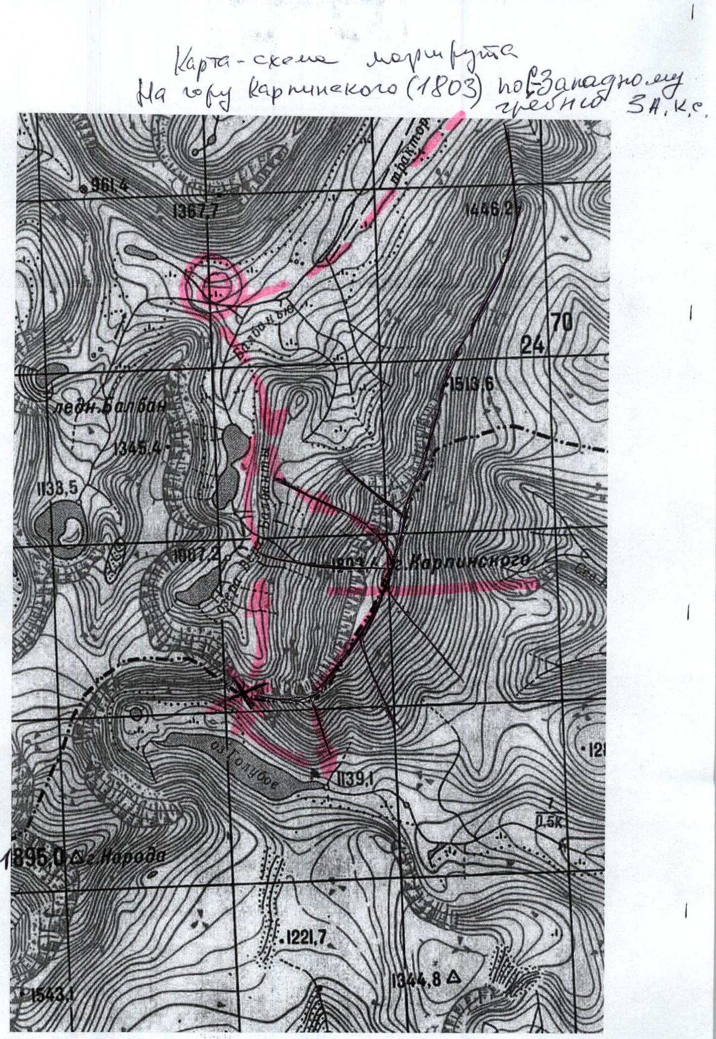
Approach: From the geologists' base – the settlement of Zhelanny – upstream along the Balbanyu river along the left (in the direction of travel) bank. 3–4 hours to the reindeer herders' campsite near Lake Maly Balbanty (after the campsite – a ford across a mountain stream), approximately the same time upwards to the traditional bivouac on the slopes of Mount Narodnaya under the Lymbeko pass.
A bright landmark on the approach from the right (in the direction of travel):
- a burned-out all-terrain vehicle.
Near it, one should cross the Balbanty river along the stones. Further, from the remains of the all-terrain vehicle to the traditional campsites under the slopes of Mount Narodnaya – about 1 hour's walk along the old all-terrain vehicle road.
Technical part of the route: From the bivouac under the Lymbeko pass, cross the Balbanty river along the stones and begin the ascent through the tundra, turning into medium-block scree, in the direction of the pronounced rocky ridge in the center of the western slope of Mount Karpinsky. A characteristic landmark is a white rock outcrop in the upper left part of the ridge into a couloir.
At the base – a control cairn – an indicator of the start of the route. Near the cairn, one should rope up. Further movement is along rocks of 2, 2 category of difficulty. Ridge. 400 m. Movement is simultaneous with insurance for ledges.
Further, there is an inclined wall with a cleft in the center, closer to the right part (3 cat. diff., 20 m), followed by a series of rocky shelves. Move, adhering to the right side of the ridge. Exit to the ridge and movement along the ridge 300–400 m. Rocks (3 cat. diff.).
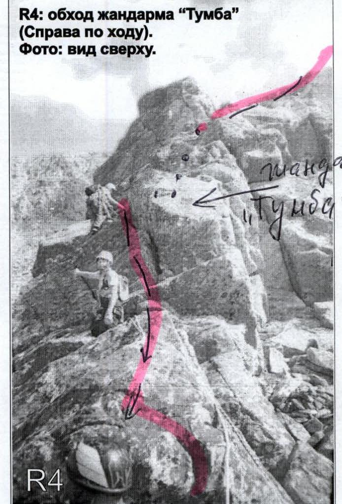
Bypass the "Tumba" gendarme (a large, pronounced gendarme in the center of the ridge) on the right along the ridge, insurance is alternate, ledges are used.
Further, there is an inclined wall – 30 m. Steepness 50–60 °, complexity 3, and continuation of movement along the ridge.
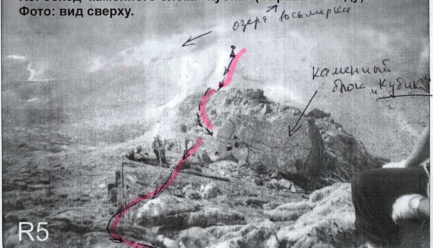
Exit under the "Kubik". This is a large rock block in the center of the ridge, held by friction. Bypass the "Kubik" on the right in the direction of travel, a rocky wall with a pronounced ridge edge.
Further movement along the ridge under the key section of the route – a rocky wall 30 m. Difficult climbing on smooth rocks, zigzagging along three rocky shelves located on the wall at an angle of 45 ° to each other. Category of difficulty – 3. After passing the key section – exit to the area of the white rock outcrop, the "White Rocks" section. Climbing a series of small walls 3–8 m, 3, 3 cat. diff., more than 500 m with a constant gain in height.
Further:
- The ridge becomes gentler;
- About 400–500 m of simultaneous movement along rocks of 2 cat. diff.;
- Exit to the scree northern ridge;
- Movement along scree (n.c.) to the right to the summit tower.
Summit tower – 10 m, rocks 1 cat. diff.
Required special mountaineering equipment for a training sports group of 4 people:
- Climbing rope – 2×50 m
- Climbing pitons – 5 pcs.
- Quickdraws – 5 pcs.
- Slings – 5 pcs.
- Ice axes – 2 pcs.
- Climbing carabiners (shared) – 5 pcs.
- Crampons – 2 pairs
- Stove (gas burner) with a kettle – 1 pc.
- Tarps – 2 pcs.
- Tent (bivouac bag) – 1 pc.
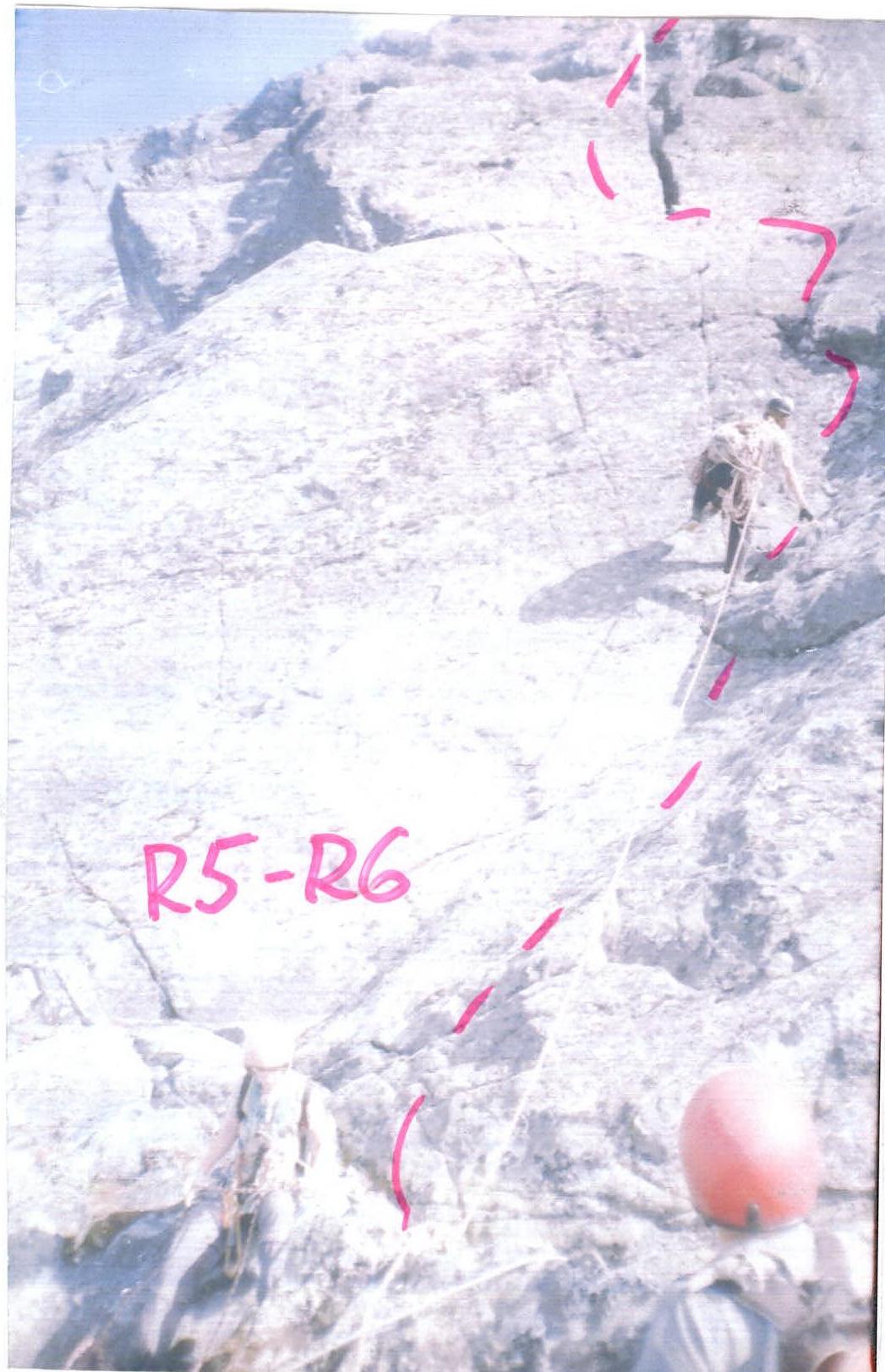
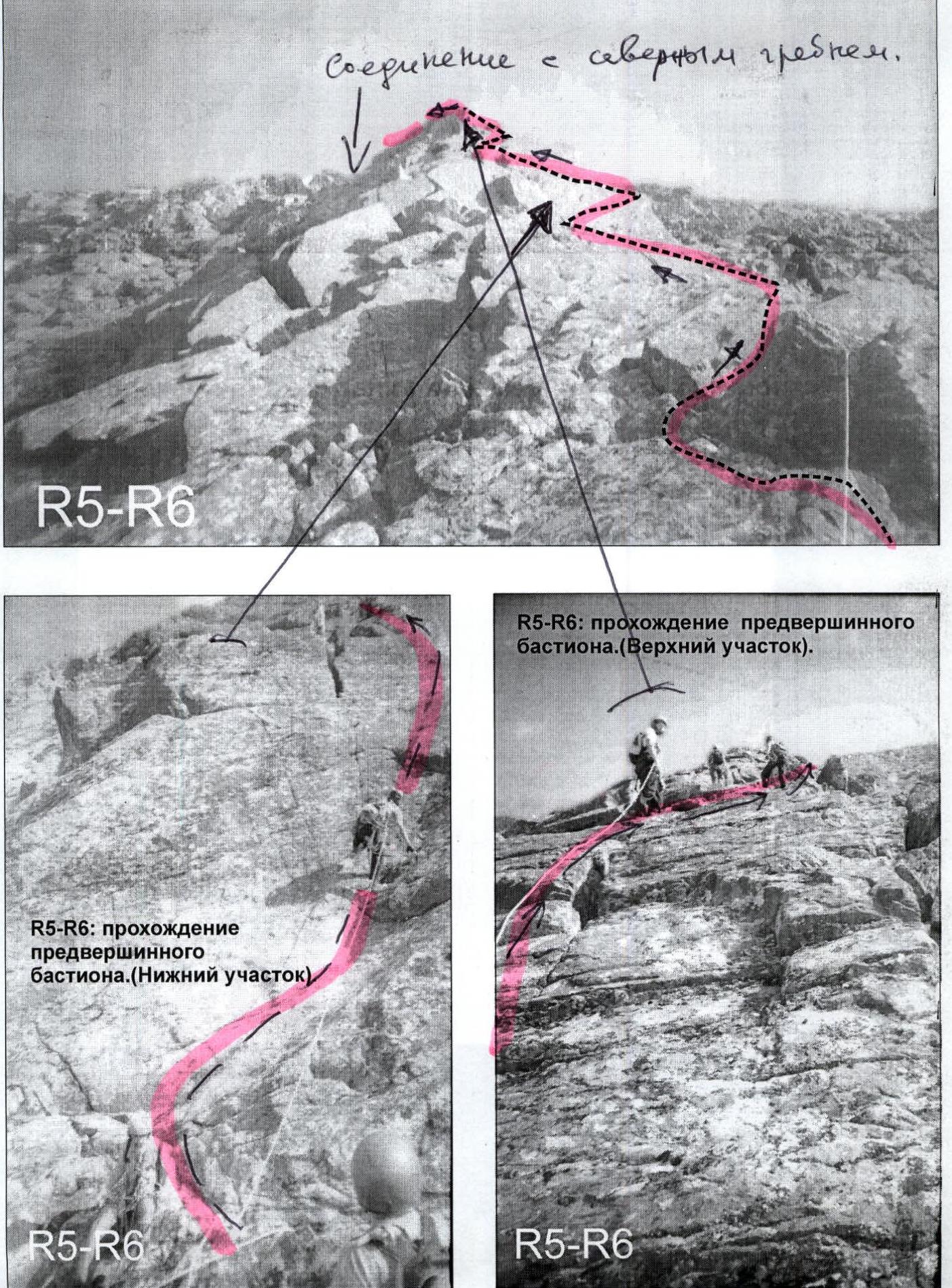
R5–R6: scheme of passing the pre-summit bastion. Connection with the northern ridge. R5–R6: passage of the pre-summit bastion. (Lower section) R5–R6: passage of the pre-summit bastion. (Upper section)
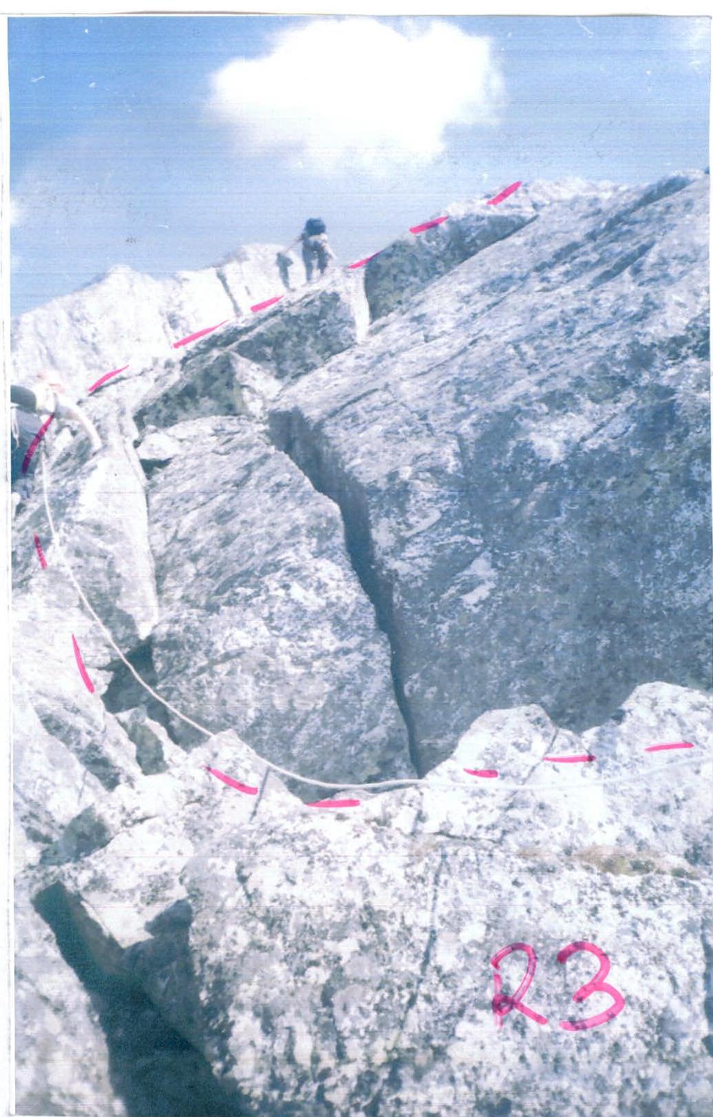
R3: passage of the key section (Wall with a cleft).

R4: bypassing the "Tumba" gendarme (on the right in the direction of travel). Photo: top view.
R5: bypassing the "Kubik" rock block (on the right in the direction of travel). Photo: top view.
 www.alpfederation.ru↗
Map-scheme of the route to Mount Karpinsky (1803) via the northwestern ridge. 3A cat. diff. 1 cm – 500 m