Climbing Route Passport
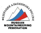
Mountain region – Subpolar Urals Gorge – Balbanyu River valley Ridge – Issledovatelsky Ridge Peak – Mount Karpinsky (1803 m) Route – along the rocky counterfort of the Eastern slope from Goluboye Lake Complexity category – 1B cat. diff. (rock)
Alpinism Federation of the Komi Republic Syktyvkar
Ascent Passport
- Region – Subpolar Urals
- Ridge – Issledovatelsky Ridge
- Gorge – Balbanyu River valley
- Section No. according to KMGV-2001 – 8. "Other mountain systems, massifs"
- Peak name – Karpinsky Peak
- Height – 1803 m
- Route name – along the rocky counterfort of the Eastern slope from Goluboye Lake
- 3.1. Proposed 1B cat. diff.
First ascent Rocky
- Height difference – 1320 m
- Route length – 2600 m
- Sections of 5 cat. diff. – none
- Sections of 6 cat. diff. – none
- Average steepness of the main (technical part) of the route – 45°
- Average steepness of the entire route – 45°
Team's walking hours:
- Approach to the bivouac "Behind the all-terrain vehicle": 1 day
- Ascent from the bivouac "Behind the all-terrain vehicle": 14 hours
Team leader: Zhuravlev Sergey Vasilyevich, Candidate Master of Sports, 2nd category instructor.
Team members:
- P. Gayner – 3rd sports category (Syktyvkar)
- I. Ivonina – 3rd sports category (Syktyvkar)
- V. Toropov – 3rd sports category (Syktyvkar)
- A. Shershov – 3rd sports category (Syktyvkar)
Coach: Zhuravlev Sergey Vasilyevich, Candidate Master of Sports, 2nd category instructor.
- Departure on the route: 7:00, June 19, 2004
- Reaching the summit: 12:00, June 19, 2004
- Return to the base camp: 14:00, June 19, 2004
Organization
Monitoring expedition of the Yugyd Va National Park and the Alpinism Federation of the Komi Republic "Polar Vertical – 2004"
Executor: Zhuravlev Sergey Vasilyevich, Syktyvkar, 167000, Internatsionalnaya St., 97, apt. 12. Phone: 24-24-91. E-mail: Zhur58@rambler.ru
To the summit of Mount Karpinsky (1803 m)
Mountain peak
16 km along the slope
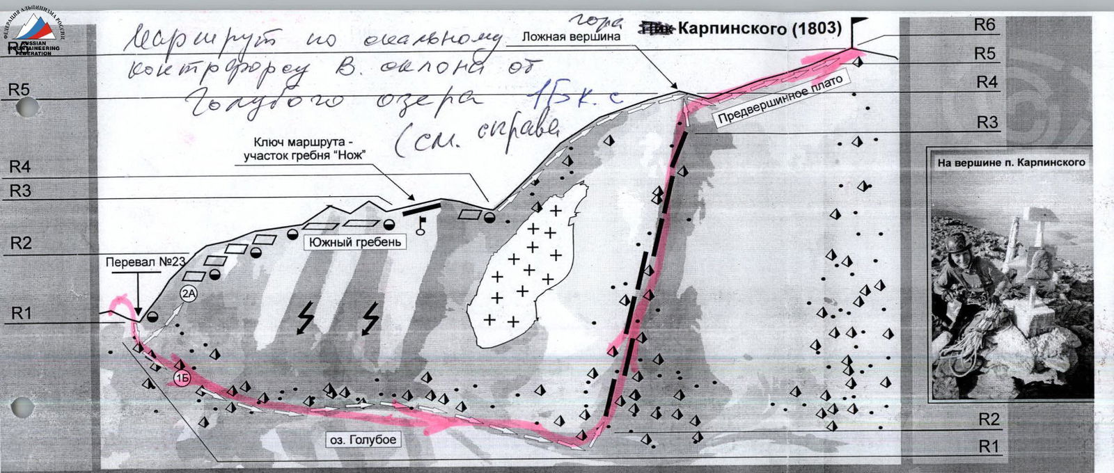
Route scheme: along the Southern ridge from the 23rd pass. 2A cat. diff.
-
R0–R1 – Ascent to the 23rd pass. (Large-block scree, beginner's category. Steepness 35–45°. The exit to the pass point is steeper – 45–55°. Approach to the pass from the right along the way).
-
R1–R2 – Ascent along the scree to the rocks. (Scree, 300 m, 45–50°, beginner's category).
-
R2–R3 – Ascent along the rocky ridge to the "Knife". (Rocks, 200–300 m, 50–60°, 2 cat. diff. Simultaneous movement with rope placement around protrusions).
-
R3–R4 – Passing the key point ("Knife"). (Rocky ridge, 100 m, 2 cat. diff. Insurance with закладными элементами, pitons (most convenient are medium-sized boxes). The complexity of the traverse of the "Knife" is 3 cat. diff., length – 15 m).
-
R4–R5 – Exit to the sub-summit. (Medium-block scree, beginner's category). Transition along the plateau to the rocky ridge of the summit tower. (Medium-block scree. Section complexity – beginner's category – 1 cat. diff.).
-
R5–R6 – Passing the rocky ridge of the summit tower. (Rocks. Heavily destroyed ridge. 40 m, 1–2 cat. diff.).
-
R6 – Summit of Karpinsky Peak.
-
R6–R0 – Descent along the route 1B cat. diff. (along the counterfort of the Eastern slope from Goluboye Lake). Then, through the 23rd pass, descent to the base camp.
Route scheme: along the counterfort of the Eastern slope from Goluboye Lake. 1B cat. diff.
-
R0–R1 – Ascent to the 23rd pass. (Grassy slopes, scree, large-block scree. Steepness 35–45°. The exit to the pass point is steeper – 50–55°. Approach to the pass from the right along the way, beginner's category).
-
R1–R2 – Approach to the base of the counterfort. (Grassy slopes, scree, large-block scree, beginner's category).
-
R2–R3 – Ascent along the counterfort. (Large-block scree. 800 m, 45–55°. Simultaneous movement on a shortened rope. In some areas, alternating insurance using protrusions on large rock blocks. Climbing complexity – 1–2 cat. diff. (in some areas)).
-
R3–R4 – Exit to the sub-summit. (Scree ridge, 500 m, 45–55°, beginner's category).
-
R4–R5 – Transition along the plateau to the rocky ridge of the summit tower. (Medium-block scree. Section complexity – beginner's category – 1 cat. diff.).
-
R5–R6 – Passing the rocky ridge of the summit tower. (Rocks. Heavily destroyed ridge. 40 m, 1–2 cat. diff.).
-
R6 – Summit of Karpinsky Peak.
-
R6–R0 – Descent along the ascent route.
Route description (OSP)
Approach: From the base of geologists – Zhelanny settlement – upstream along the Balbanyu River valley on the left (along the way) bank. 3–4 hours to the reindeer herders' camp near Maly Balbanty Lake (after the camp – fording a mountain stream), approximately the same time upstream to the traditional bivouac on the slopes of Narodnaya Peak under the Limbeko pass. A bright landmark on the approach from the right (along the way) – a burnt-out all-terrain vehicle. Near it, one should cross the Balbanty River along the stones. Further from the remains of the all-terrain vehicle to the traditional camps under the slopes of Narodnaya Peak – about 1 hour of walking along the old all-terrain vehicle road.
Technical part of the route: From the bivouac under the Limbeko pass (camp "Behind the all-terrain vehicle"), cross the Balbanty River along the stones and start ascending through the tundra, transitioning into medium-block scree. Reach Vosmyorka Lakes. Then, along the right bank of the lakes (along the way – left) approach the beginning of the ascent to the 23rd pass. The ascent is quite steep, rocky. Inclined rocky shelves of varying steepness, for novice groups, require rope installation. After ascending to the pass – descend down to Goluboye Lake and along the lake's shore to its lower part and approach the base of the rocky counterfort. Here, novices should tie in, put on protective helmets. Further movement along the well-defined counterfort. (Heavily destroyed rocks. Large stone blocks. About 1000 m of the ridge. Average steepness 33–50°, in some areas up to 60°. Then exit to the southern false summit and the pre-summit plateau. Further movement along the scree (beginner's category) to the right to the summit tower. Summit tower – 10–15 m, rocks 1 cat. diff.).
Descent along the ascent route.
Required special mountaineering equipment for a training and sports group of 10 people: climbing rope – 3 × 40 m, climbing pitons – 5, climbing carabiners (shared) – 5, crampons – 2 pairs, stove (gas burner) with a pot – 1, raincoats – 10, tent (bivouac bag) – 1.
Note for the instructor: the route is more often used for the descent of sports groups from the summit of Mount Karpinsky than for independent ascents. Subjectively, it is stonefall-prone.