Peak 1159.0 m (Dinozavr Glavny) Route: via the western edge of the northern wall cat. difficulty — 3B (rocky) approximately Leader: E. Donyushko Polar Urals, mountain range Raiiz Section in KMGV — 8.3 E-mail — ZHUR58@RAMBLER.RU
Report
On the first ascent of the climbing route to the peak 1159.0 m (Dinozavr Glavny) "Via the western edge of the northern wall 3B cat. difficulty (rocky)". At the climbing event "Climbing Festival 'Polar Mountains-2012' NP 'Club of Northern Travels 'Sauk-Pai' (Syktyvkar)".
Region: Yamalo-Nenets Autonomous Okrug of Tyumen Oblast. Mountain country: Polar Urals. Valley: valley of the Nyrvomen-Shor river. Mountain range: Raiiz massif. Peak: 1159.0 (Dinozavr Glavny). Route: via the western edge of the northern wall. Difficulty level: 3B cat. difficulty (rocky).
Prepared by: E. Donyushko, Zhuravlev S. September 2012.
Description of the peak
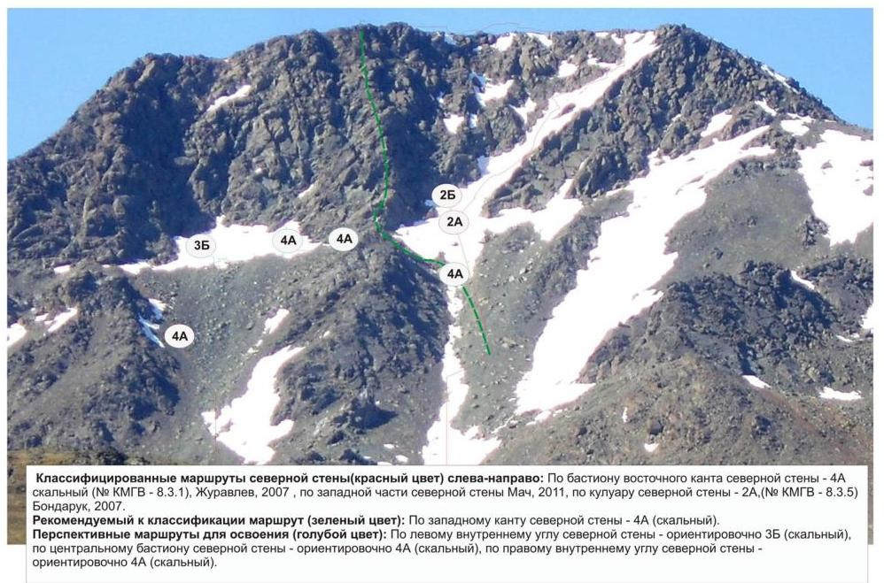
Peak 1159.0 (Dinozavr Glavny) is located on the west of the Raiiz mountain massif in the Polar Urals, in the valley of the Nyrvomen-Shor river. Territorially, it is situated in the Yamalo-Nenets Autonomous Okrug of Tyumen Oblast.
Due to the convenience of logistics (the approach from the Sob' railway station to the Nyrvomen-Shor river valley takes only three to four hours), the peak is the most освоен by climbers among all the peaks of the Polar Urals.
Routes of categories 1B to 4A have been laid to the peak.
For the full climbing development of the peak, it remains to pass three logical lines on the northern wall:
- via the western edge of the Northern wall — passed during the climbing festival "Polar Mountains" in July 2012.
Description of the route
The route "Via the western edge of the northern wall" is a typical sporting rock route of 3B cat. difficulty, with a full set of natural obstacles corresponding to routes of this level. The route is logical and easily determined from the base camp in the Nyrvomen-Shor river valley, making it convenient for conducting educational and sporting climbing events as an educational or sporting route, as the movement of the group along the complex rocky relief is controlled with binoculars and well-functioning VHF communication.
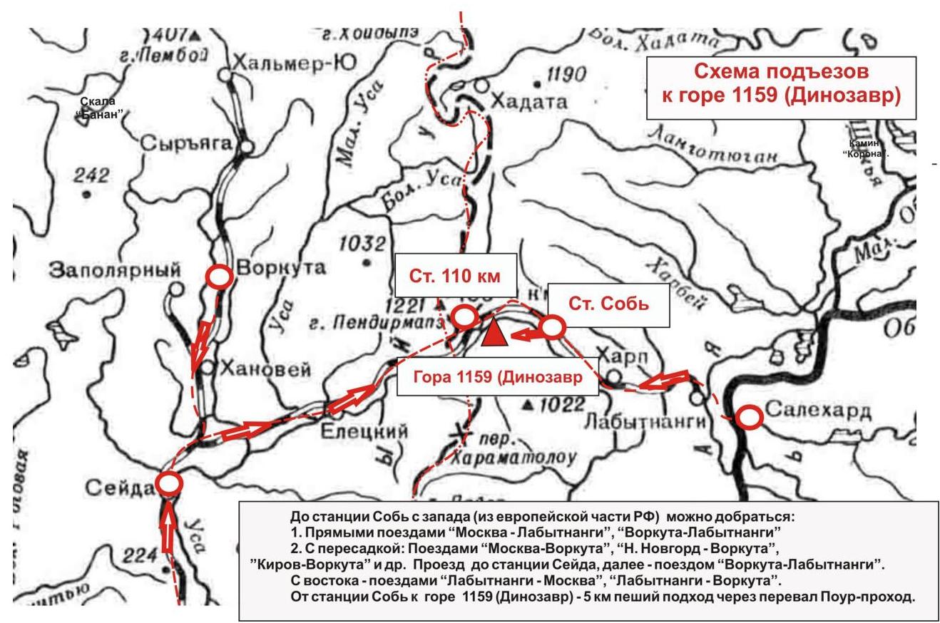
Approach: the ascent is made from a bivouac (Nyrvomen-Shor delta camp). First, cross to the left (orographic) bank of Nyrvomen-Shor, then ascend through the mountain tundra to the base of the couloir. Then, via the snow-ice (in rare warm summers — scree) couloir, ascend to the "Klyk" gendarme located in the central part of the western edge.
Under the "Klyk" gendarme, there is a convenient place for organizing rope teams. From this point, the technical part of the route begins.
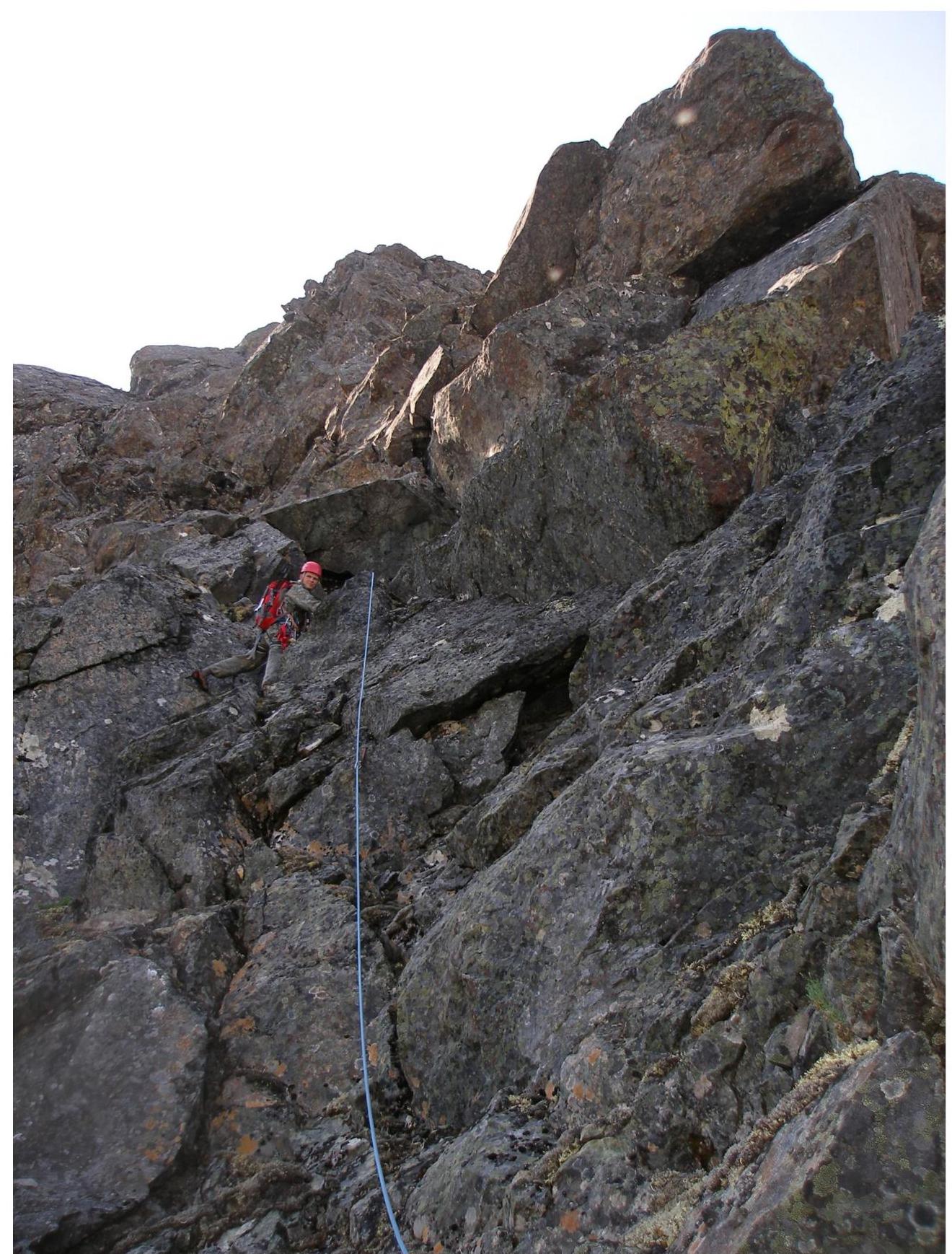
Technical part: the route starts with an ascent along a rocky wall to the rocky ridge of the western edge. The first and quite complex technical spot requires movement in rock shoes and careful work by the first climber in the rope team.
The wall is climbed using a crack that narrows in the upper part. Then, there is a smoothed "ram's forehead" requiring balanced and friction movement. The relief then simplifies and turns into a series of small inclined walls leading to the key of the route.
The key of the route: the internal angle "Kniga s probkoy" (Book with a cork). A pronounced internal angle with a huge stone block jammed in the upper part, creating a cornice with an overhang of 1–0.5 m. Passing the cornice requires a high level of rock climbing or the use of artificial aids (IT).
On the ledge under the key:
- a convenient station,
- there is a control cairn set by the first ascensionists.
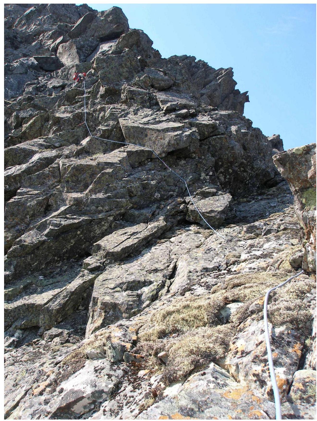
After passing the key — the internal angle "Kniga s probkoy" — there is a section called "Katuschki" (Coils). This is a cascade of small smoothed walls. The most complex spot is a wall in the center with a minimum of relief for organizing belay points. It is passed on the right (in the direction of travel). After passing the "Katuschki" section, there is a section called "Levye plity" (Left slabs). The rocky slope of the western edge on the left in the direction of travel is more gentle, and from the ridge, it is convenient to move to a cascade of inclined slabs. The slabs abut against a ярко expressed wall with two cracks. The ascent to the summit ridge is made via the right crack. Further, the route does not present technical difficulties, as it leads to the summit via a destroyed rocky ridge turning into a scree plateau.
The summit is a destroyed scree dome of large stone blocks. There is a triangulator on the summit. A note by O. Kolesnikova and Yu. Bykhovtsev from August 6, 1953, who made an ascent of category 3B difficulty, was found.
Descent from the summit: the descent is made to the southwest along the destroyed ridge, then to the western ridge. Along the western ridge, descend to the western couloir. Then, descend by snow to the Nyrvomen-Shor valley. The descent follows the route of category 1B difficulty.
Equipment: for a two-person sports team to complete the ascent, the following special equipment is necessary:
-
Personal standard
-
Group:
- Main rope 9 mm — 2 × 50 m
- Rock hammer — 2 pcs.
- Rock pitons — 16 pcs.
- Ice axe — 1 pc.
- Nuts — 12 pcs.
- Friends — 6 pcs.
- Extractor — 2 pcs.
- Ice screws — 0 pcs.
- Quickdraws — 16 pcs.
- Slings — 10 pcs.
Passport
- Section number according to KMGV — 2010 — 3.8.
Polar Urals, Raiiz mountain massif
- Name of the peak: 1159.0 (Dinozavr Glavny)
Height: 1159.0 m. Route: via the western edge of the northern wall
- Cat. difficulty: 3B
- Character of the route — rocky.
- Height difference of the route: 460 meters
- Length of the route: 1080 meters
- Length of sections of the highest category of difficulty:
Sections:
- 1 cat. difficulty — 1 section — 800 m
- 2 cat. difficulty — 0 sections — 0 m
- 3 cat. difficulty — 4 sections — 170 m
- 4 cat. difficulty — 4 sections — 48 meters
- 5 cat. difficulty — 2 sections — 5 meters
- 6 cat. difficulty — 0 sections — 0 meters.
- Average steepness: main part of the route — 60 degrees.
entire route — 55 degrees.
9. Pitons used:
Total pitons used on the route:
- rock pitons — 9,
- nuts — 25,
- stationary pitons — 0,
- artificial aids — 0,
- removable pitons — 0. Pitons left on the route: total — 0; including stationary — 0.
-
Departure on the route — 6:00, August 7, 2012.
| Arrival at the summit — | 16-00, | 07.07. 2012 | | ---------------------- | ------ | ----------- | | Return to base camp — | 20-00, | 07.07 .2012 |
-
Team's total climbing hours: — 14 hours.
-
Leader: E. Donyushko (2nd sports category, Ukhta).
Participants: A. Goletarov (2nd sports category, Inta)
- Coach: Zhuravlev S. V. (CMS, instructor-methodologist 1st category,
Syktyvkar)
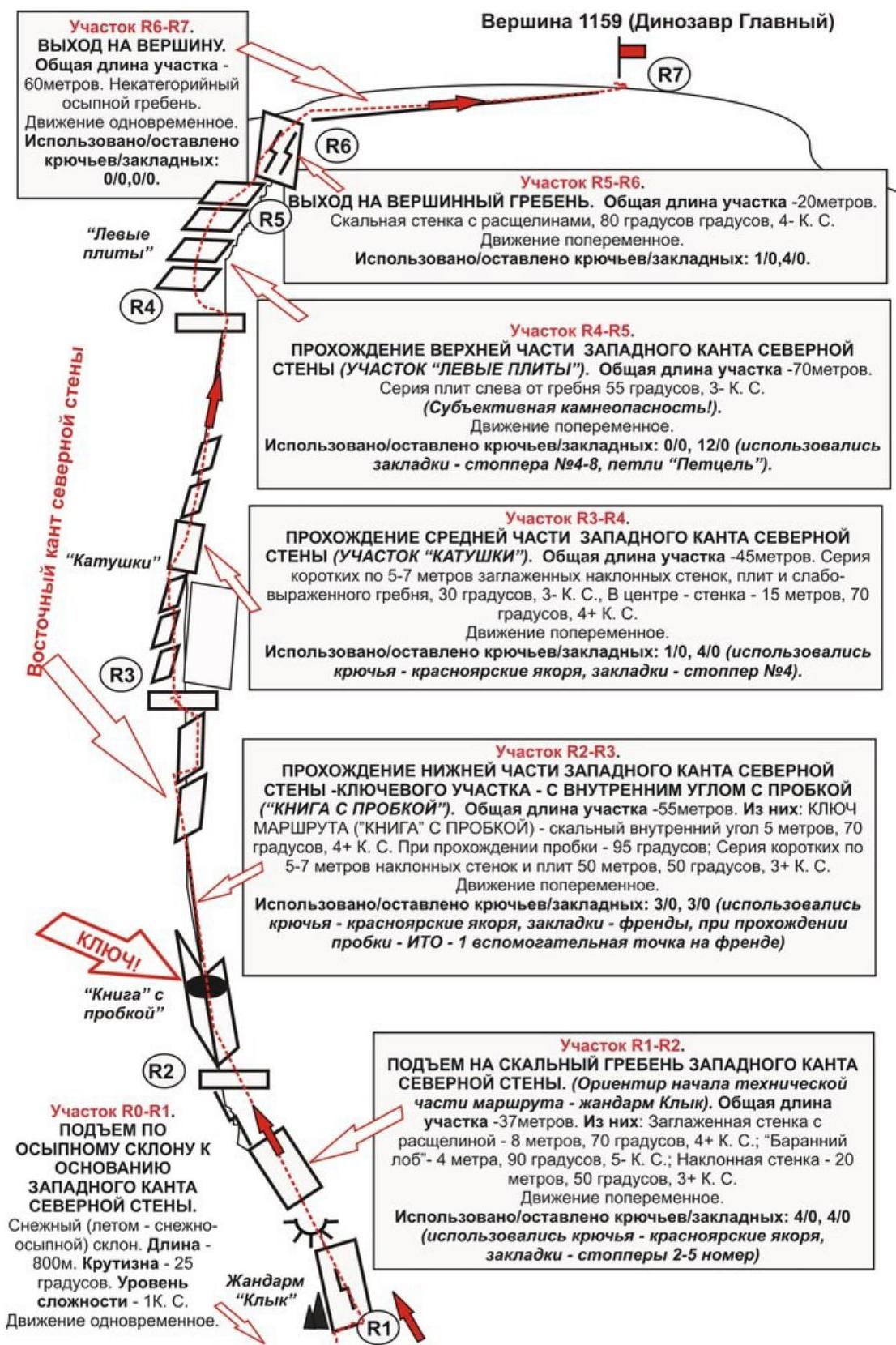
Section R1–R2, ascent to the rocky ridge of the western edge of the northern wall. (Landmark for the start of the technical part of the route — "Klyk" gendarme). Total length of the section — 37 m. Of these:
- Smoothed wall with a crack — 8 m, 70°, 4+ cat. difficulty
- "Ram's forehead" — 4 m, 90°, 5− cat. difficulty
- Inclined wall — 20 m, 50°, 3+ cat. difficulty
Movement is alternate. Pitons/nuts used/left: 4/0, 4/0 (piton type — Krasnoyarsk anchors, nuts type — stoppers sizes 2–5)
Peak 1159.0 (Dinozavr Glavny) Route: "Via the western edge of the Northern wall" 3B (rocky) (table of natural obstacles on the route)
| Section | Length | Steepness | Character of relief | Category of difficulty | Number of pitons/nuts |
|---|---|---|---|---|---|
| R0 — start of the route. Entry into the couloir | |||||
| R0–R1 — ascent under the base of the western edge of the Northern wall to the "Klyk" gendarme — the place for organizing rope teams | 800 | 25 | snow-scree slope | 1 | 0 / 0 |
| R1–R2 — ascent to the rocky ridge of the western edge | 8 4 20 | 70 90 50 | Wall with a crack "ram's forehead" — wall | 4+ 5- 3+ | 4 / 0,4 / 0 |
| R2–R3 — passing the key — the internal angle "Kniga s probkoy" (total length 55 m) and a series of walls | 5 (1,5) 50 | 90 (95) 50 | Internal angle with a cork — series of small walls | 4+ 5- 3+ | 3 / 03 / 0 |
| R3–R4 — passing the "Katuschki" section | 30 15 | 30 70 | Series of small walls — in the center of the section — wall | 3- 4+ | 1 / 04 / 0 |
| R4–R5 — passing the upper part of the edge. Section "Levye plity" | 70 | 55 | Inclined slabs | 3- | 0 / 012 / 0 |
| R5–R6 — exit to the summit ridge | 20 | 80 | Wall with cracks | 4- | 1 / 04 / 0 |
| R6–R7 — exit to the summit. | 60 | 10-15 | Destroyed ridge | n/k | |
| :-- | :-- | :-- | :-- | :-- | :-- |
| R7 — summit 1159 | |||||
| Descent from the summit | Along simple rocks to the western ridge, then along the destroyed rocky ridge to the western couloir and down — to the Nyrvomen-Shor river valley |
Summary
Length of the route — 1080 m. Average steepness — 55°. Character of relief — rocky
Sections:
- 1 cat. difficulty — 1 section — 800 m
- 2 cat. difficulty — 0 sections — 0 m
- 3 cat. difficulty — 4 sections — 170 m
- 4 cat. difficulty — 4 sections — 48 m
- 5 cat. difficulty — 2 sections — 5 m
Pitons and nuts used: 9/25. Pitons and nuts left: 0/0
R1–R2. Exit to the ridge of the rocky edge (upper part of the section).
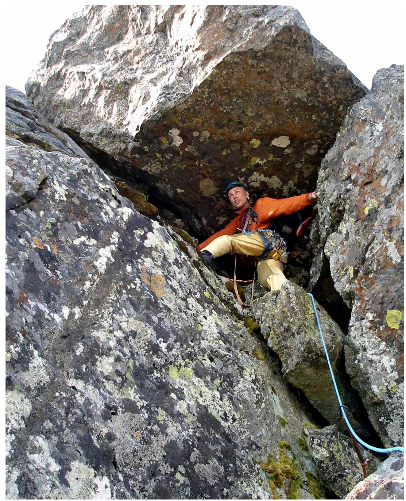
R2–R3. Passing the key — the internal angle "Kniga s probkoy". Upper part of the internal angle — stone block-cork.
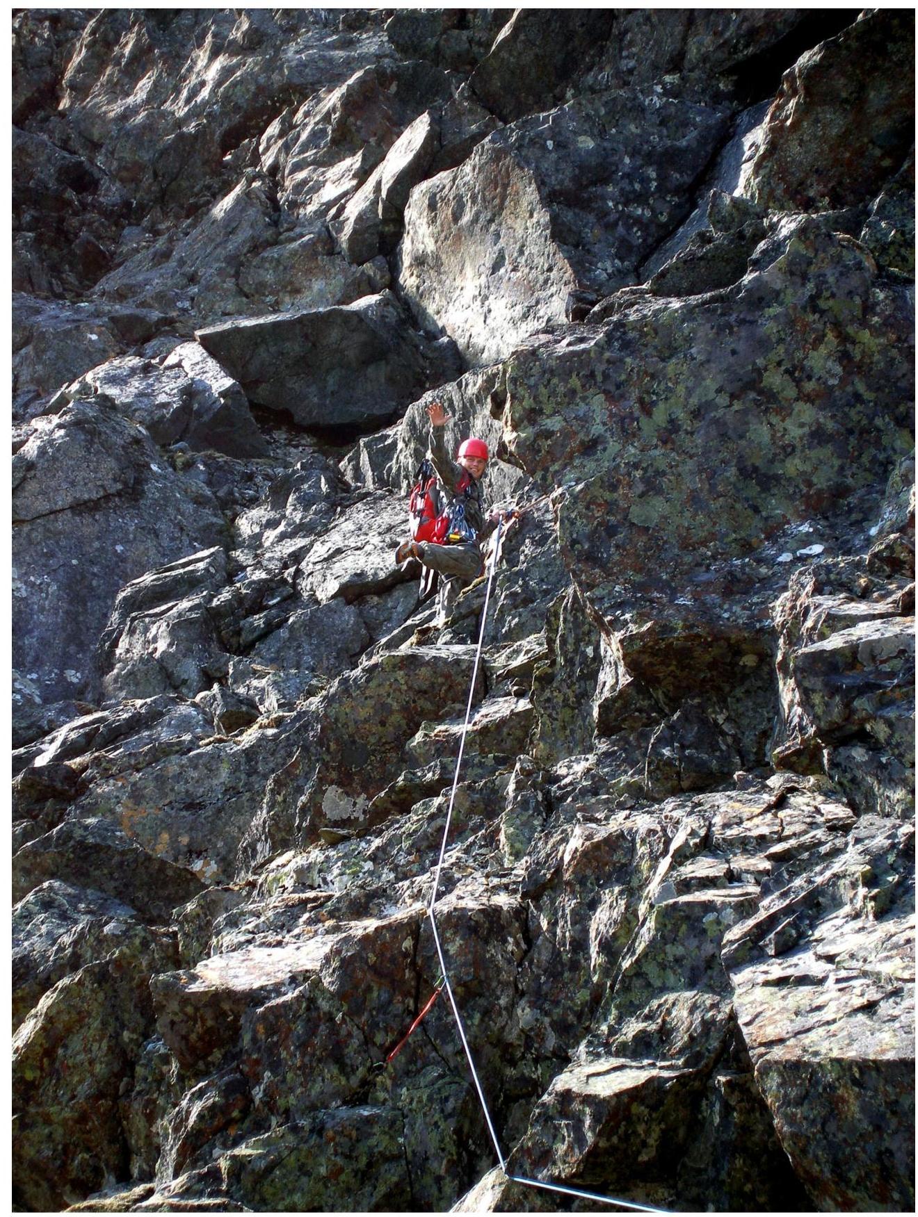
R3–R4. Section "Katuschki".
R4–R5. Section "Levye plity".
R5–R6. Exit to the summit ridge. Wall with cracks.
