Ascent Passport
Mountain region — Polar Urals
Mountain range — Rai-Iz mountain massif
Gorge — Nyrdvomyn-Shor river valley.
Section number according to KMGV-2001 — #8. "Other mountain systems and massifs".
Name of the summit — 1159 (Dinozavr Glavnyy).
Height — 1159 m
Route name — via the first buttress of the central rock massif of the northern wall of the western ridge
Complexity category — 3B cat. diff.
Route character — rock
Height difference — 950 m (according to the map of the General Staff of the Russian Federation: initial mark — 199 m, summit — 1159 m).
Route length — 3 km (rocky section — 800 m)
Technically difficult sections — sections of 5 cat. diff. — none, 6 cat. diff. — none.
Average steepness of the main part of the route — 50°, (technical) part of the route — 60°.
Pitons on the route: left — 0. Used pitons — 6, chocks — 18 pcs.
Team's walking hours — 10.
Group composition:
- leader S. L. Maltsev (1st sports category, Ukhta)
- E. V. Donyushko (2nd sports category, Ukhta)
Departure onto the route — 6:00 July 1, 2007
Reached the summit — 14:00 July 1, 2007
Returned to base camp — 16:00 July 2, 2007
Organizations conducting the alpine event — "Alpinistskaya ekspeditsiya Federatsii alpinizma Respubliki Komi, Non-Profit Partnership 'Klub severnykh puteshestviy 'Sauk-Pai'" (Syktyvkar) and the Club of tourists and climbers of Ukhta.
Dates of the alpine event — from June 25 to July 10, 2007.
Senior coach — FARCK (Federation of Alpinism of the Republic of Komi)
F. N. Fomenko (CMS, instructor-methodologist 1st category, cert. #07, Ukhta)
Senior coach — releasing the alpine event
S. V. Zhuravlev (CMS, instructor-methodologist 2nd category, cert. #1124, Syktyvkar)
Federation of Alpinism of the Republic of Komi
Syktyvkar, 2007

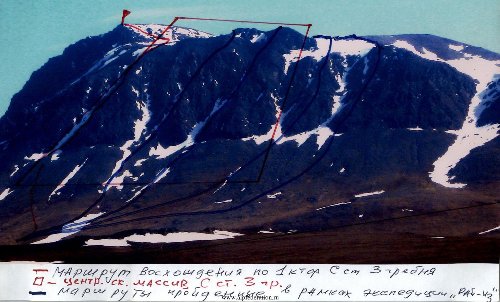
Peak 1159 (Dinozavr Glavnyy) cat. 3 gr.
— Ascent route via the 1st buttress N st. W ridge
— central rock massif N st. 3 gr.
Routes completed during the "Rai-43" expedition.
Summit Description
The summit 1159 (Dinozavr Glavnyy) is located in the Rai-Iz mountain massif of the Polar Urals, within the Yamalo-Nenets Autonomous Okrug of the Russian Federation beyond the Arctic Circle.
A characteristic feature of the routes to this summit via the northern wall of the western ridge are complex rock buttresses with an abundance of various rock relief, from small inclined walls and slabs to prolonged internal corners, often ending in cornices at the beginning, and prolonged movement along a heavily destroyed, rocky- talus ridge when ascending to the summit. A feature of the Polar Urals summits is that the complexity increases sequentially from the start of the route to the summit tower.
The height difference from the start of the route (mark at the water's edge at the base camp in the Nyrdvomyn-Shor river valley above sea level 199 m, summit — 1159 m) is more than 800 m.
The summit 1159 (Dinozavr Glavnyy) is included in the list of classified summits. The first routes to this summit were laid by Ukhta climbers in the winter seasons of 95–99. They also gave the summit its climbing name, as this summit does not have an independent name.
From the Nyrdvomyn-Shor stream valley, the most convenient location for a base camp — a large larch-alder oasis in the tundra — the summit is easily recognizable by its pronounced rock walls and buttresses of the northern and northern wall of the western ridge.
www.alpfederation.ru↗
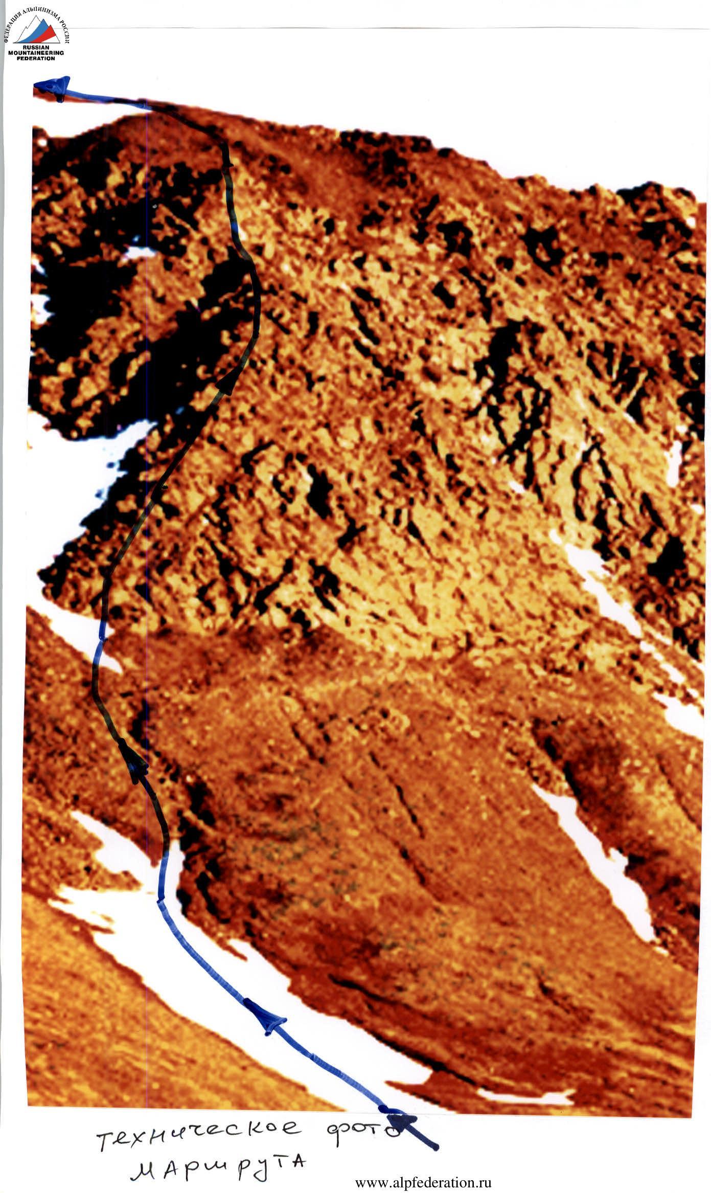
Technical photo of the Route
Summit 1159 (Dinozavr Glavnyy)
Route: via the first buttress of the central rock massif of the northern wall of the western ridge
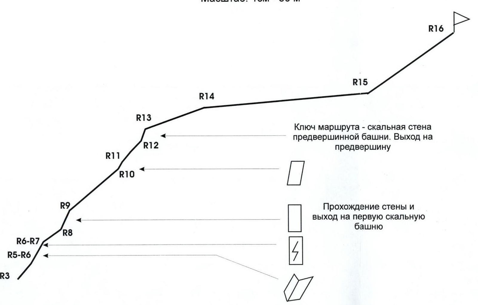
Graphical profile of the technical part of the route with indication of the most complex sections
Scale: 1 cm — 50 m
Route key — rock wall of the pre-summit tower. Exit to the pre-summit.
Passing the wall and exiting onto the first rock tower.
Profile of the technical part of the Route
Route Description
The route: The first buttress of the central rock massif of the northern wall of the western ridge of summit 1159 (Dinozavr Glavnyy) resembles a triangle. This buttress is the closest to the summit. From the base camp in the Nyrdvomyn-Shor river valley, it is clearly visible.
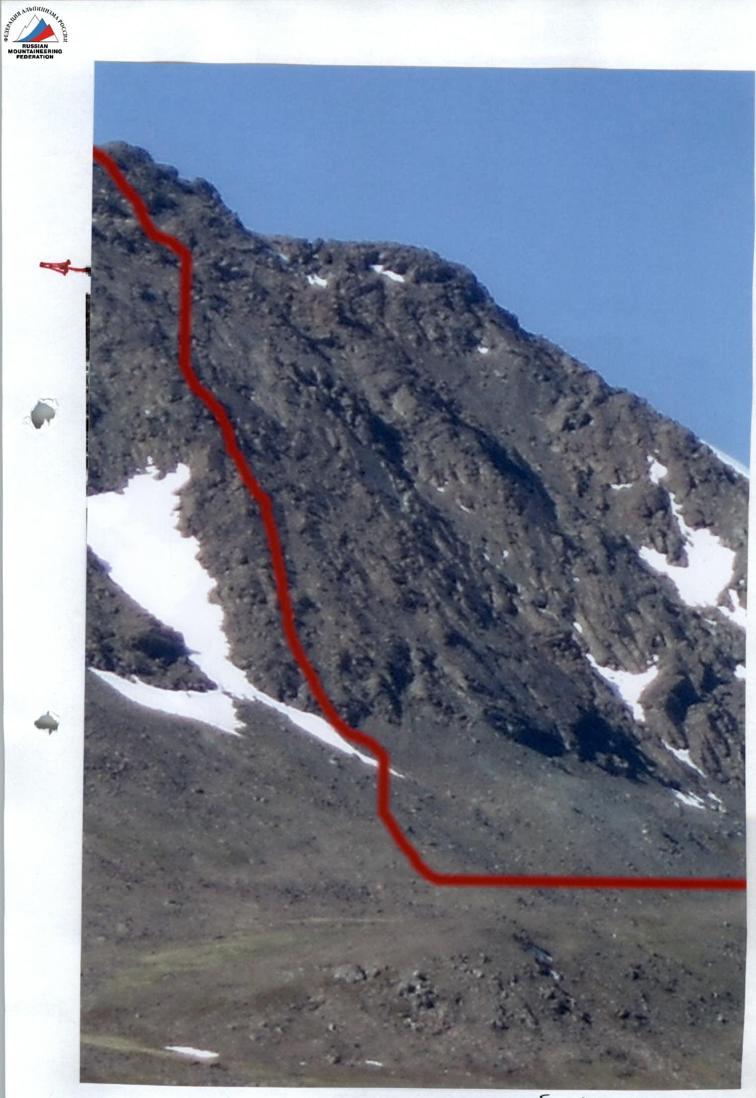
Approach: Moving from the bivouac in the Nyrdvomyn-Shor river valley (see attached map-diagram), ford the Nyrdvomyn-Shor river, go around the green bald mountain to the right (in the direction of travel), and ascend along the snowy (talus) fields to a large rock remnant. From it, to the left in the direction of travel, traverse along the talus slopes, along the snowy fields, approach the rocky slope of the first (from left to right from the summit) buttress of the central rock massif of the western ridge. At the base of the buttress on the large-block talus, organize a rope team.
A characteristic landmark at the start of the route — there is no clearly visible landmark, but the smoothed wall of the left slope suggests a logical move to the right in the direction of travel towards a pronounced rock rib.
Technical Part of the Route
To the right of the smoothed monoliths along a clearly visible rock rib, pass to an inclined wall. On the left on the ridge, a characteristic gendarme "Ushi" is visible.
Along the inclined wall with an abundance of cracks and ledges, approach the base of an internal corner. Along the internal corner, rocks of medium complexity, bypass to the right a rock mirror and exit under a wall with a crevice. The inclined wall with a crevice is passed head-on and leads to a long inclined oblique shelf going left onto the ridge of the buttress.
Along the shelf, approach under the first rock tower. The tower is limited by drops into couloirs. It is passed head-on along rocks of medium complexity.
From the tower, along a prolonged, jagged rocky ridge, approach a series of ridge walls of the second rock tower. The exit to the second rock tower is simpler on the right side.
Further — exit onto the ridge. The ridge is jagged, made of dense rocks, but not complex to pass, and is traversed simultaneously. It leads under the rock tower of the pre-summit.
Route key: The exit onto the rock tower of the pre-summit is the key place on the route. Dense, steep rocks with an abundance of holds and footholds but with a minimum of places for organizing intermediate belays.
After passing the key place and exiting onto the pre-summit, and then onto the western ridge, the route is not complex. Along snowy-talus fields, approach under the summit talus dome. Further along simple rocks of 1–2 complexity categories and large-block talus, ascend to the summit.
The summit is well-defined. On the summit — a triangulation mark.
Equipment: for a sports group of people: main rope 2 pcs × 10 mm × 50 m. Rock pitons — 10 pcs. Chocks — 12 pcs.: small stoppers — 16, "Parus" stoppers — 6, hexes — 4. Station loops — 6 pcs, quickdraws — 10 pcs. Primus (gas burner) — 1 pc. Pot — 1 pc. Personal standard equipment — for each participant.
For the Instructor's Attention
- The route meets the requirements for training-sporting routes of 3 cat. diff. Rocks on the route are dense, monolithic. Rockfall hazard — subjective, dependent on the participants themselves.
Technical Description to the Route Diagram in UIAA Signs
R0 — base camp in the larch oasis of the Nyrdvomyn-Shor river.
R0–R1 — Base camp — crossing the Nyrdvomyn-Shor river.
Crossing the Nyrdvomyn-Shor river ford (depth 40–60 cm, during periods of abundant snowmelt, organization of belay is required). Section length — 500 m, steepness — 0–5°. Complexity level — non-categorized.
R1–R2 — Bypassing the green bald mountain and approaching the rock remnant on the green talus.
Mountain tundra, talus. Section length — 2500 m. Section steepness: initially 30–45°, in the upper part 45–50°. Complexity level — non-categorized.
R2–R3 — Traversing talus and snowy slopes, ascending along destroyed rocks to the base of the first buttress to organize a rope team.
Large-block talus, snow. Section length — 200 m. Section steepness — 45–50°. Complexity level — 1 cat. diff. Belay during movement along large rock blocks — gymnastic.
R3–R4 — Bypassing the right mirror along the rock rib. Exiting under an oblique rock wall.
Rocks. Convenient holds and footholds, abundant cracks and faults for organizing belays. Section length — 50 m. Steepness — 50°. Complexity level — 3 cat. diff. Alternating belay.
R4–R5 — Passing the oblique wall and exiting under an internal corner.
Dense rocks with an abundance of ledges and holds. Section length — 20 m. Section steepness — 60°. Complexity level — 2, 3 cat. diff. Convenient station for belay on a small shelf. Participants move in turns.
R5–R6 — Passing the internal corner and exiting under a wall with a fracture.
Internal corner that is convenient to bypass the rock mirror located on the ridge. Rocks with an abundance of holds and cracks for organizing belays. Section length — 25 m. Section steepness — 60°. Complexity level — 3 cat. diff. Piton belay, using chocks. Mandatory quickdraws to reduce friction. Participants move in turns.
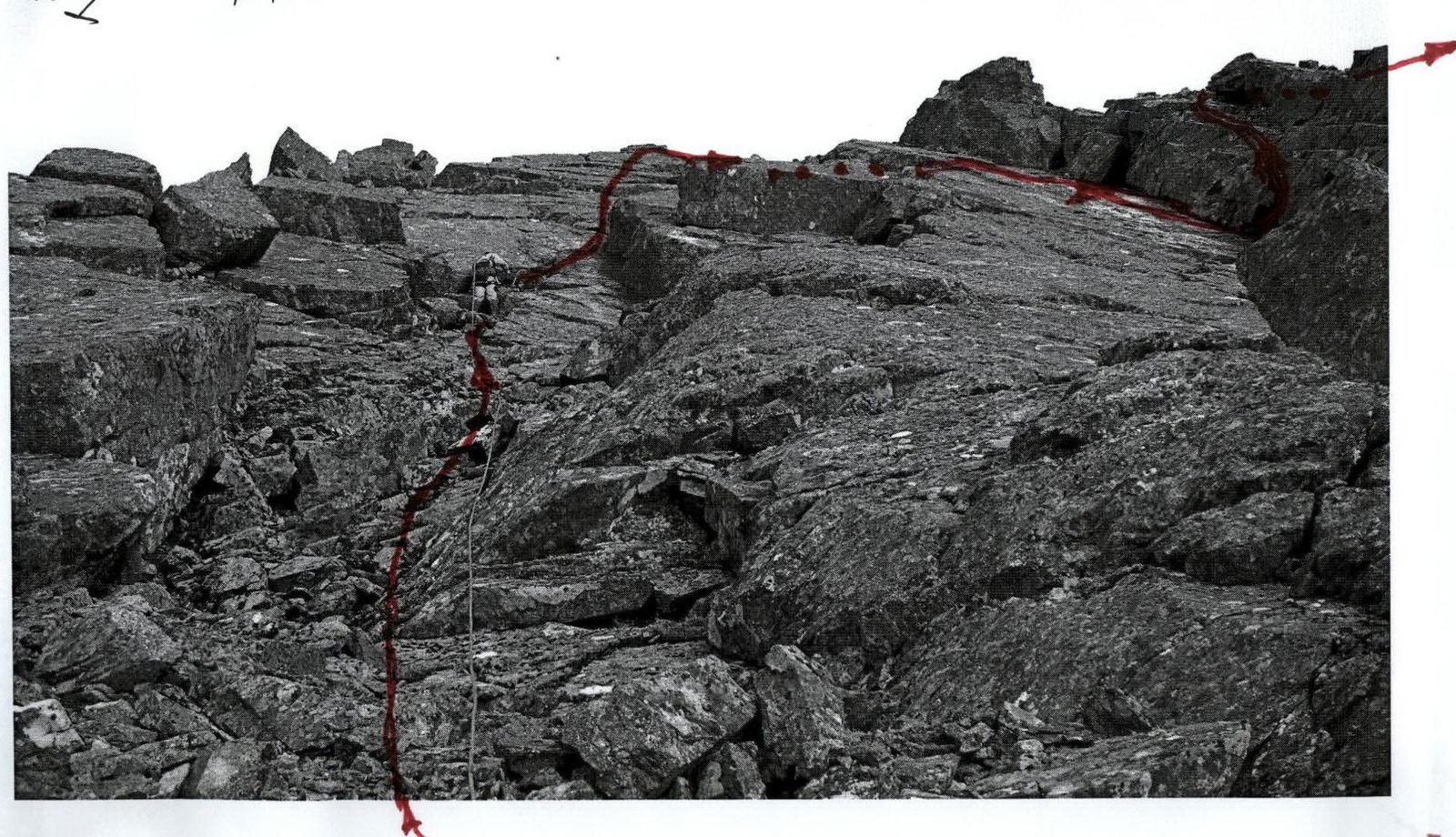
R6–R7 — Passing the wall with a fracture and exiting onto an oblique shelf crossing the ridge of the buttress.
Monolithic rocks. Section length — 20 m. Section steepness — 60°. Complexity level — 3 cat. diff. Group movement with alternating belay. Exit onto a convenient rock shelf crossing the ridge of the buttress.
R7–R8 — Exiting onto the rocky ridge of the buttress.
Traversing along an inclined rock shelf. (Left in the direction of travel). Section length — 50 m. Section steepness — 30–35°. Complexity level — 2 cat. diff. Movement — alternating. Piton belay. Using chocks, loops thrown over ledges.
R8–R9 — Passing the wall and exiting onto the first rock tower.
Monolithic rocks. Minimum holds, minimum cracks for organizing intermediate belays. Section length — 50 m. Section steepness: in the lower part — 65°. Complexity level — 3 cat. diff. Movement — alternating. Belay — piton, using chocks.
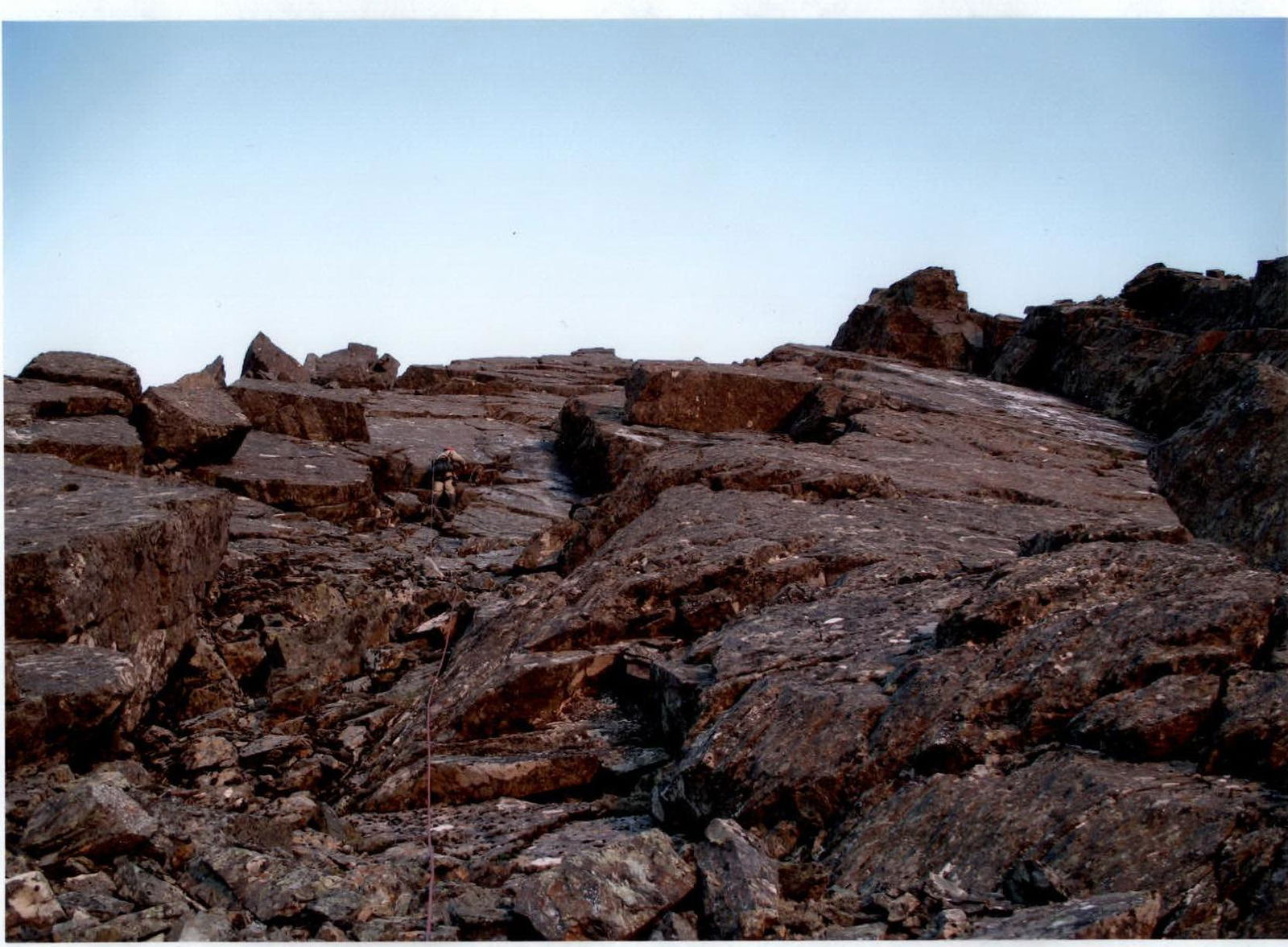
R9–R10 — Passing the rocky ridge. Exiting under a series of oblique walls.
Heavily jagged rocky-talus ridge. Section length — 150 m. Steepness — 40°. Complexity level — 1, 2 cat. diff. Simultaneous movement.
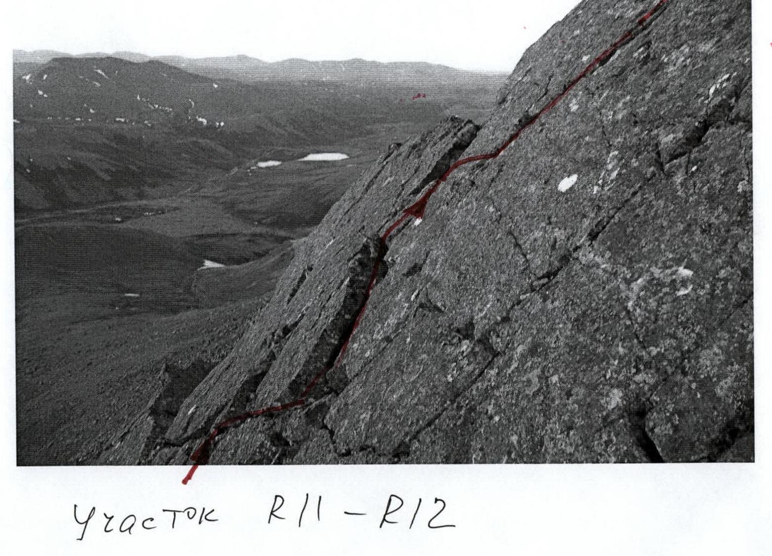
R10–R11 — Passing an oblique inclined wall.
Route key section R13 #6

| Length | Steepness | Complexity | Pitons | Chocks | Photo # | ||
|---|---|---|---|---|---|---|---|
| R16 | |||||||
| R15 | 250 m | 35° | 2 cat. diff. | 0 | 0 | ||
| R14 |  | 400 m | 5° | N/c. | 0 | 0 | |
| R13 | 150 m | 20° | N/c. | 0 | 0 | ||
| R12 | Key | 30 m | 70° | 3, 4 cat. diff. | 2 / 1 | 10 | #6 |
| 40 m | 45° | 2 cat. diff. | 0 | 0 | #5 | ||
| R11 | 30 m | 50° | 3 cat. diff. | 0 | 8 | # | |
| R10 | 20 m | 60° | 3, 4 cat. diff. | 4 | 10 | # | |
| R9 | 150 m | 40° | 1, 2 cat. diff. | 0 | 0 | # | |
| R8 | 50 m | 65° | 3 cat. diff. | 5 / 1 | 8 | # | |
| R7 | 50 m | 35° | 2 cat. diff. | 0 | 0 | # | |
| R6 | 20 m | 60° | 3 cat. diff. | 0 | 6 | # | |
| R5 | 25 m | 60° | 3 cat. diff. | 0 | 6 | #2a | |
| R4 | 20 m | 60° | 2, 3 cat. diff. | 0 | 4 | # | |
| R3 | 50 m | 50° | 3 cat. diff. | 0 | 12 | # |
Monolithic rocks. Section length — 20 m. Section steepness — 60°. Complexity level — 3, 4 cat. diff. Movement — alternating. Organizing belay with the help of pitons and chocks.
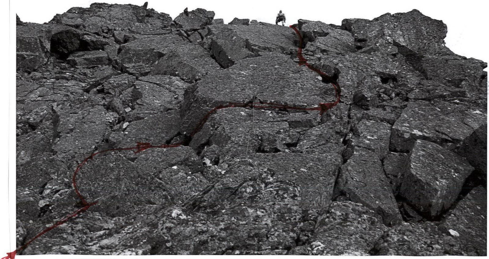
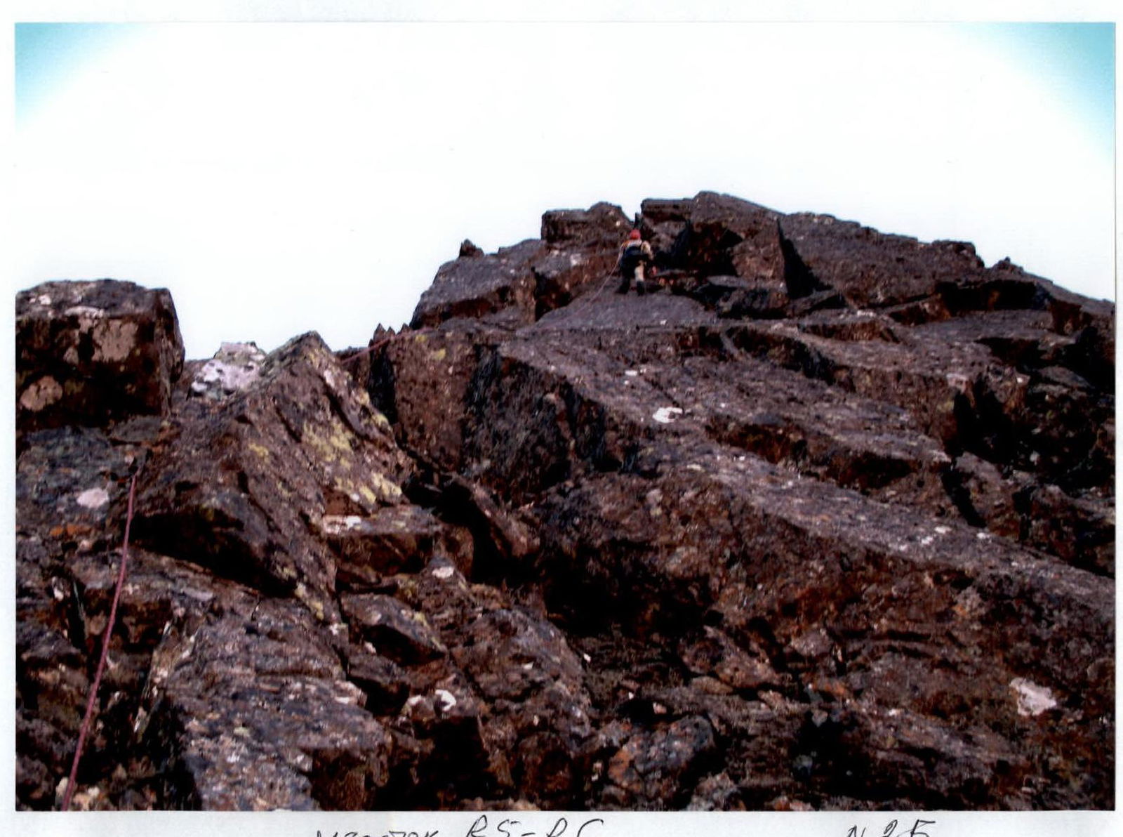
R11–R12 — Passing the wall and ascending along the rocky ridge under the key place on the route — the pre-summit tower.
Rocks. Inclined wall. Section length — 30 m. Steepness — 50°. Complexity level — 3 cat. diff. Alternating movement.
Rocky ridge. Section length — 40 m. Section steepness — 45°. Complexity level — 2 cat. diff.
R12–R13 — Passing the key place — the rock wall of the pre-summit tower. Exiting onto the pre-summit.
Monolithic rocks with a minimum of places for organizing intermediate belays. Section length — 30 m. Steepness — 70°. Complexity level — 3, 4 cat. diff. Alternating movement. Organizing belay with the help of pitons and chocks.
R13–R14 — Exiting onto the western ridge and the pre-summit plateau.
Talus, destroyed rocky ridge. Section length — 150 m. Section steepness — 20°. Complexity level — n/c. Simultaneous movement. Gymnastic belay.
R14–R15 — Approaching along the plateau under the rocky summit dome.
Talus. Section length — 400 m. Section steepness — 5°. Complexity level — n/c. Simultaneous movement. Gymnastic belay.
R15–R16 — Passing the rocky massif of the summit dome and exiting along the ridge to the summit.
Rocks. Section length — 250 m. Section steepness — 35°. Complexity level — 2 cat. diff. Simultaneous movement, on a shortened rope. Organizing belay through ledges.
R16 — summit 1159 (Dinozavr Glavnyy).
R16–R0 — Descent via route 1B (z) to the center of the eastern slope. Talus, snow. Crossing the Nyrdvomyn-Shor river over snow bridges. (Snow bridges in the summer are subjectively dangerous!). All-terrain vehicle road through the mountain tundra. Section length — 4–5 km. Complexity level: in the upper part — 1 cat. diff., in the lower part — non-categorized.
www.alpfederation.ru↗
Section R8–R9
Section R3–R4
Section R5–R6
Section R5–R6 #2b

Section R11–R12
Section R11–R12 (top)