Ascent Log
Mountain Region — Polar Urals
Mountain Range — Rai-Iz mountain massif
Gorge — Nyrdvomen-Shor river valley.
Section No. according to KMGV-2001 — No. 8. "Other mountain systems and massifs"
Name of the summit — 1159 (Dinozavr Glavnyy). Height — 1159 m. Route name — via the left part of the western rock massif of the northern wall of the western ridge. Category of difficulty — 3A. Route type — rock climbing. Height difference — 950 m (according to the map of the General Staff of the Russian Federation: initial mark — 199 m, summit — 1159 m). Route length — 4–5 km. Technically challenging sections — no sections of 5th or 6th category of difficulty. Average steepness of the main (technical) part of the route — 55°. Average steepness of the entire route — 45°. Pitons left on the route — none. Pitons used — 6, chocks — 12. Team's walking hours — 10. Group composition:
- team leader V. Toropov (2nd sports category, Syktyvkar)
- participant P. Bondaruk (2nd sports category, Syktyvkar)
- participant Yu. Valuzhis (2nd sports category, Syktyvkar)
- participant O. Ermolin (2nd sports category, Syktyvkar)
Departure to the route — 7:00 AM on July 8, 2007. Reaching the summit — 2:00 PM on July 8, 2007. Return to the base camp — 5:00 PM on July 8, 2007.
Organization conducting the alpine event — "Alpinist Expedition of the Alpinism Federation of the Komi Republic, NP 'Club of Northern Travels 'Sauk-Pai' (Syktyvkar) and the Club of Tourists and Alpinists of Ukhta".
Dates of the alpine event — from June 25 to July 10, 2007.
Senior Coach — Release Representative of FARK (Federation of Alpinism of the Komi Republic)
- F. N. Fomenko (CMS, instructor-methodologist 1st category, certificate No. 07, Ukhta)
Senior Coach — Release Representative of the alpine event
- S. V. Zhuravlev (CMS, instructor-methodologist 2nd category, certificate No. 1124, Syktyvkar)
Federation of Alpinism of the Komi Republic Syktyvkar, 2007
Summit 1159 (Dinozavr Glavnyy). Northern wall of the western ridge.
- ROUTE: Via the left part of the western rock massif of the northern wall of the western "ridge".
- ROUTES COVERED DURING THE "RAI-IZ – 2007" EXPEDITION.
Description of the summit
Summit 1159 (Dinozavr Glavnyy) is located in the Rai-Iz mountain massif of the Polar Urals, within the Yamalo-Nenets Autonomous Okrug of the Russian Federation, beyond the Arctic Circle.
A characteristic feature of the routes to this summit is the height difference from the start of the route (mark of the base camp's location above sea level — 199 m to the summit — 1159 m), i.e., a difference of over 800 m.
Another feature of the Polar Urals summits is the sequential increase in difficulty from the start of the route to the summit tower.
Summit 1159 (Dinozavr Glavnyy) is included in the list of classified summits. The first routes to this summit were laid by Ukhta alpinists during the winter seasons of 95–99. They also gave the summit its alpinist name, as it does not have an independent name.
From the valley of the Nyrdvomen-Shor stream, the most convenient location for a base camp — a large larch-alder oasis in the tundra — the summit is easily recognizable by its pronounced rock walls and buttresses of the northern and northern walls of the western ridge.
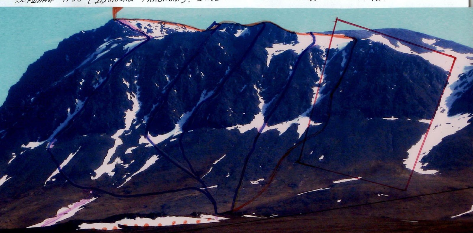
The northern wall of the western ridge is characterized by distinct rock massifs with characteristic buttresses, separated by couloirs leading to the western ridge and the pre-summit plateau under the rock-scree tower of the summit.
The western rock massif is separated from the central one by a rock buttress and a snowy couloir.
 Technical photo of the route from the Nyrdvomen-Shor river valley
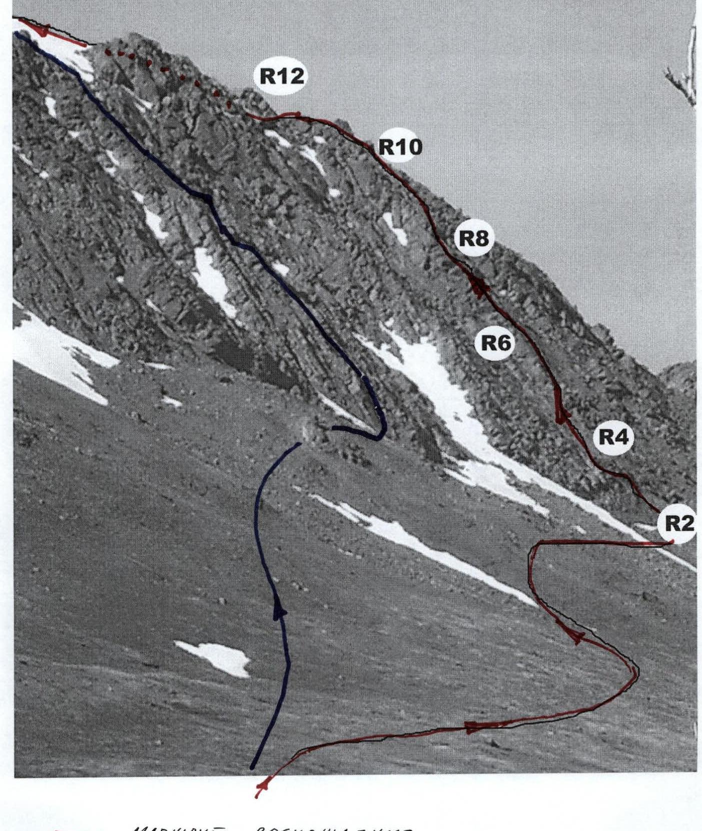
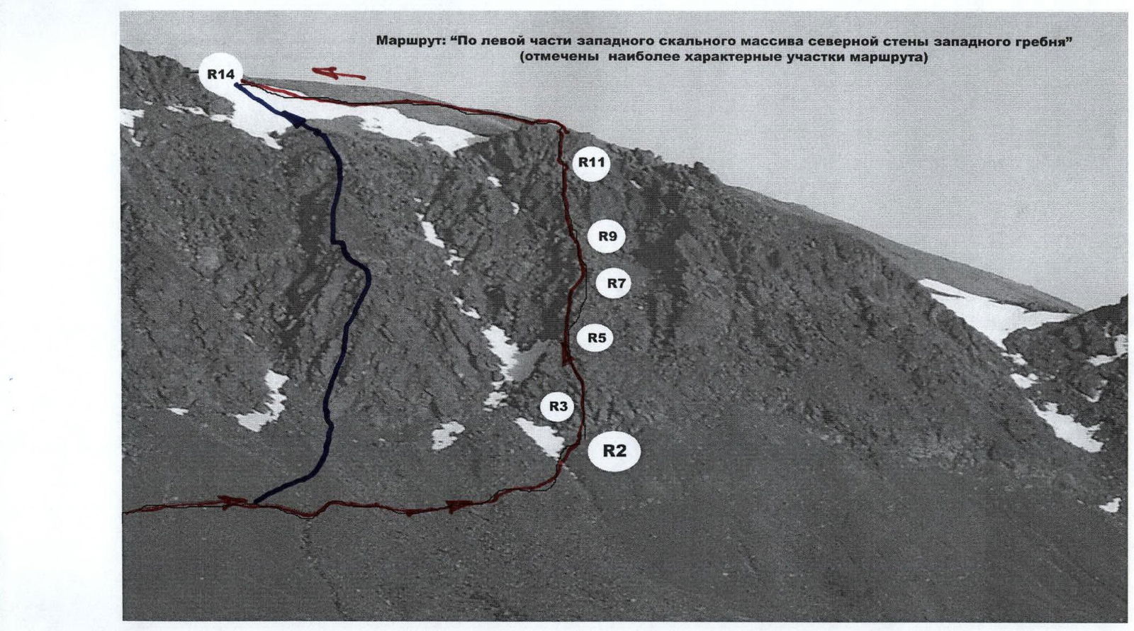 Ascent routes: Western buttress of the northern wall of the western ridge
Route description
The route: "Via the left part of the western rock massif of the northern wall of the western ridge" is clearly visible from the base camp in the Nyrdvomen-Shor river valley. The rock massif is separated from the main rock massif of the wall by a western buttress and a pronounced snowy couloir.
Approach: Moving from the bivouac in the Nyrdvomen-Shor river valley (see the attached map-scheme), cross the Nyrdvomen-Shor river at the all-terrain vehicle ford (width of the section — 25–30 m, depth of the ford — 0.6 m during low water). Then, along the mountain tundra, and subsequently along the scree slopes, ascend to the western rock massif. At the base of the rock massif, it's not difficult to find a convenient platform for organizing the rope team.
Technical part of the route: the technical part of the route begins with a not very steep, above average complexity internal corner. The internal corner leads to the ridge of a weakly expressed buttress. Further along the ridge, along a series of ledges and small walls of moderate steepness, move simultaneously on a shortened rope to an inclined wall. The wall is of medium complexity with an abundance of convenient holds and footholds, and places for organizing intermediate belay points. A certain complexity is presented by the presence of moss on small ledges of the wall. The wall again leads to the weakly expressed ridge of the left buttress of the massif. Further movement is along a technically несложный rock ridge. The ridge section leads under a rock wall with a crack in the center. The wall is climbed via the crack. Then, again along the ridge, exit under a wall with an overhanging section. The wall with the overhang is bypassed via несложные chimneys. A challenging section is encountered when exiting the second chimney onto the ridge, but this section is short — 5–7 m. Further movement is along the ridge of the buttress of varying complexity. Since the ridge section features practically all forms of rock relief: chimneys, cracks, slabs, small walls, this section is named "Surprises". It is climbed with alternate belay. The "Surprises" ridge leads to the scree dome of the sub-summit. Then, exit onto the pre-summit plateau. Move along the plateau under the summit tower. The ascent to the summit from the south is via несложные rocks, large-block scree, and then along a rock ridge.
The summit is well-defined, composed of large blocks. Climbing is несложное. On the summit — a triangulation sign.
Descent from the summit — the safest route is: "Via the center of the eastern slope and the eastern ridge" (1B category of difficulty). In the summer, this is a safe, not steep, prolonged snowy couloir allowing the group to descend with minimal time loss to the geological all-terrain vehicle road. The most challenging section during descent is crossing the upper reaches of the Nyrdvomen-Shor river on snow bridges, which in summer requires organization of belay.
Equipment: for a sports group of four people: main rope 2 pcs. × 10 mm × 50 m; rock pitons — 10 pcs.; chockstones — 12 pcs.; anchor slings — 6 pcs.; quickdraws — 10 pcs.; stove (gas burner) — 1 pc.; pot — 1 pc.; personal gear — for each participant.
 Route profile from the Nyrdvomen-Shor river valley
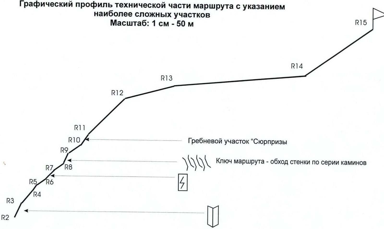 Summit: 1159 (Dinozavr Glavnyy). Route: via the left part of the western rock massif of the northern wall of the western ridge. Graphical profile of the technical part of the route indicating the most challenging sections. Scale: 1 cm — 50 m
Technical description of the route on the UIAA sign scheme
R0 — base camp in the larch oasis of the Nyrdvomen-Shor river.
R0–R1 — base camp – crossing the Nyrdvomen-Shor river.
Crossing the Nyrdvomen-Shor river by wading (depth 40–60 cm, during the period of abundant snowmelt, organization of rope belay is required). Length of the section — 500 m, steepness — 10°. Level of complexity — non-categorized.
R1–R2 — approach to the start of the route to the left part of the western rock massif. Organization of the rope team after passing the scree ledge under the internal corner. At the base of the internal corner, a control cairn marks the start of the route.
Mountain tundra, scree. Length of the section — 2500 m. Steepness of the section: initially 30–45°, in the upper part 45–50°. Level of complexity — non-categorized.
R2–R3 — passage of the internal corner. Monolithic rocks. Well-defined internal corner.
Length of the section — 50 m. Steepness of the section — 65°. Level of complexity — 3. Belay is alternate.
R3–R4 — passage of a series of ledges and small walls of moderate steepness. Rocks. Convenient holds and footholds, abundance of cracks and fissures for organizing belay points.
Length of the section — 45 m. Steepness of the section — 45–50°. Level of complexity — 2, 2+.
Movement is simultaneous on a shortened rope, with organization of belay on projections.
R4–R5 — passage of an inclined wall. Monolithic rocks, but with an abundance of holds and footholds, and places for organizing intermediate belay points.
Length of the section — 30 m. Steepness of the section — 50–55°. Level of complexity — 3.
R5–R6 — exit to the ridge of the buttress and passage of a strongly destroyed rock-scree ridge section. Approach under the wall with a crack in the center.
Strongly destroyed rocks. (Subjective rockfall danger!). Convenient holds and footholds, abundance of cracks and fissures for organizing belay points.
Length of the section — 40 m. Steepness of the section — 35°. Level of complexity — 2, 2+.
Movement is simultaneous on a shortened rope, with organization of belay on projections.
R6–R7 — passage of the wall with a crack. Monolithic rocks.
Length of the section — 35 m. Steepness of the section — 45°. Level of complexity — 2+.
Group movement with alternate belay. Exit to a convenient rock ledge to the right of the ridge.
R7–R8 — passage of the ridge section.
Strongly destroyed rocks. (Subjective rockfall danger!). Convenient holds and footholds, abundance of cracks and fissures for organizing belay points.
Length of the section — 40 m. Steepness of the section — 35°. Level of complexity — 2, 2+.
Movement is simultaneous on a shortened rope, with organization of belay on projections.
R8–R9 — bypassing the ridge wall with an overhang via a series of inclined chimneys (to the right).
Monolithic rocks, using anti-friction and chimney climbing techniques. Places for organizing intermediate belay points are sufficient. For intermediate belay points, large-sized chockstones were used.
Length of the section — 30 m. Steepness of the section — 60°, at the exit from the second chimney — 70°. Level of complexity — 3+. Movement with alternate belay.
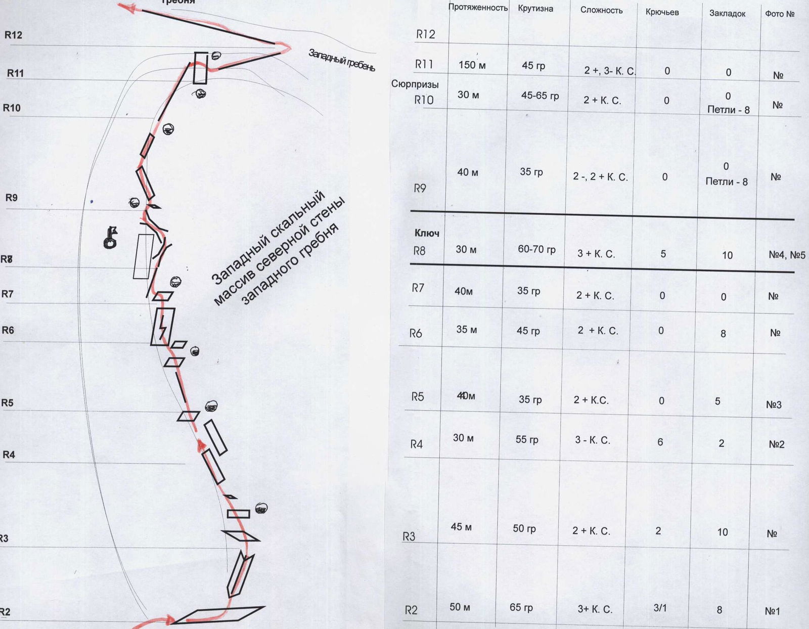 UIAA sign scheme: Summit 1159 (Dinozavr Glavnyy). Route: "Via the left part of the western rock massif of the northern wall of the western ridge"
R9–R10 — passage of the rock ridge with a series of small ridge walls and slabs.
Strongly destroyed rocks. (Subjective rockfall danger). Convenient holds and footholds, abundance of cracks and fissures for organizing belay points.
- Length of the section — 40 m
- Steepness of the section — 35°
- Level of complexity — 2, 2+.
Movement is simultaneous on a shortened rope, with organization of belay on projections. On wall sections, belay is alternate. Wall sections are 5–7 m, 3.
R10–R11 — passage of the "Surprises" ridge section. (The section is named so because over 30 m, technically несложные walls, internal corners, and chimneys of 5–7 m alternate):
- walls
- internal corners
- chimneys
Rocks. Length of the section — 30 m. Steepness — 45–65°. Level of length complexity — 2+. Movement is simultaneous, on individual sections — alternate.
R11–R12 — passage of a series of ridge rock walls, exit to the scree ridge and sub-summit.
Rocks, large-block scree transitioning to medium-block. Length of the section — 150 m.
Steepness of the section:
- in the lower part — 45°
- in the middle part — 60°
Level of complexity:
- in the lower part — 2+
- in the middle part — 3
Movement is simultaneous. Organization of belay via projections, slings on projections, large stone blocks. Movement is simultaneous, on a shortened rope. On walls of the middle part — alternate.
R12–R13 — descent to the pre-summit plateau. Scree, destroyed rock ridge.
Length of the section — 150 m. Steepness of the section — 15°. Level of complexity — n/c.
Movement is simultaneous. Belay is gymnastic.
R13–R14 — approach along the plateau under the summit rock dome. Scree.
Length of the section — 400 m. Steepness of the section — 5°. Level of complexity — n/c.
Movement is simultaneous. Belay is gymnastic.
R14–R15 — passage of the rock massif of the summit dome and exit along the ridge to the summit. Rocks.
- Length of the section — 250 m
- Steepness of the section — 35°
- Level of complexity — 2, 2+
- Movement is simultaneous, on a shortened rope
- Organization of belay — via projections
R15 — summit 1159 (Dinozavr Glavnyy).
R15–R0 — descent via the center of the eastern slope. Scree, snow. Crossing the Nyrdvomen-Shor river on snow bridges. (Snow bridges in summer are subjectively dangerous!). All-terrain vehicle road through the mountain tundra.
Length of the section — 4–5 km. Level of complexity:
- in the upper part — 1, 1+ category of difficulty
- in the lower part — non-categorized.
 №1. Section R2–R3 (middle of the internal corner)
 №2. Section R4–R5 (inclined wall)
 №3. Section R5–R6 (exit to the ridge)
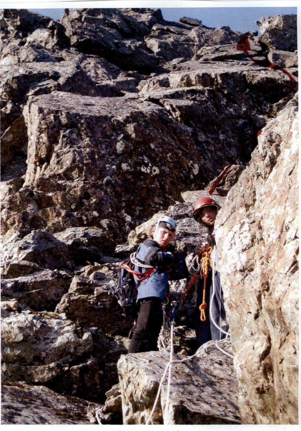 №4. Section R8–R9 (lower part of the key section)
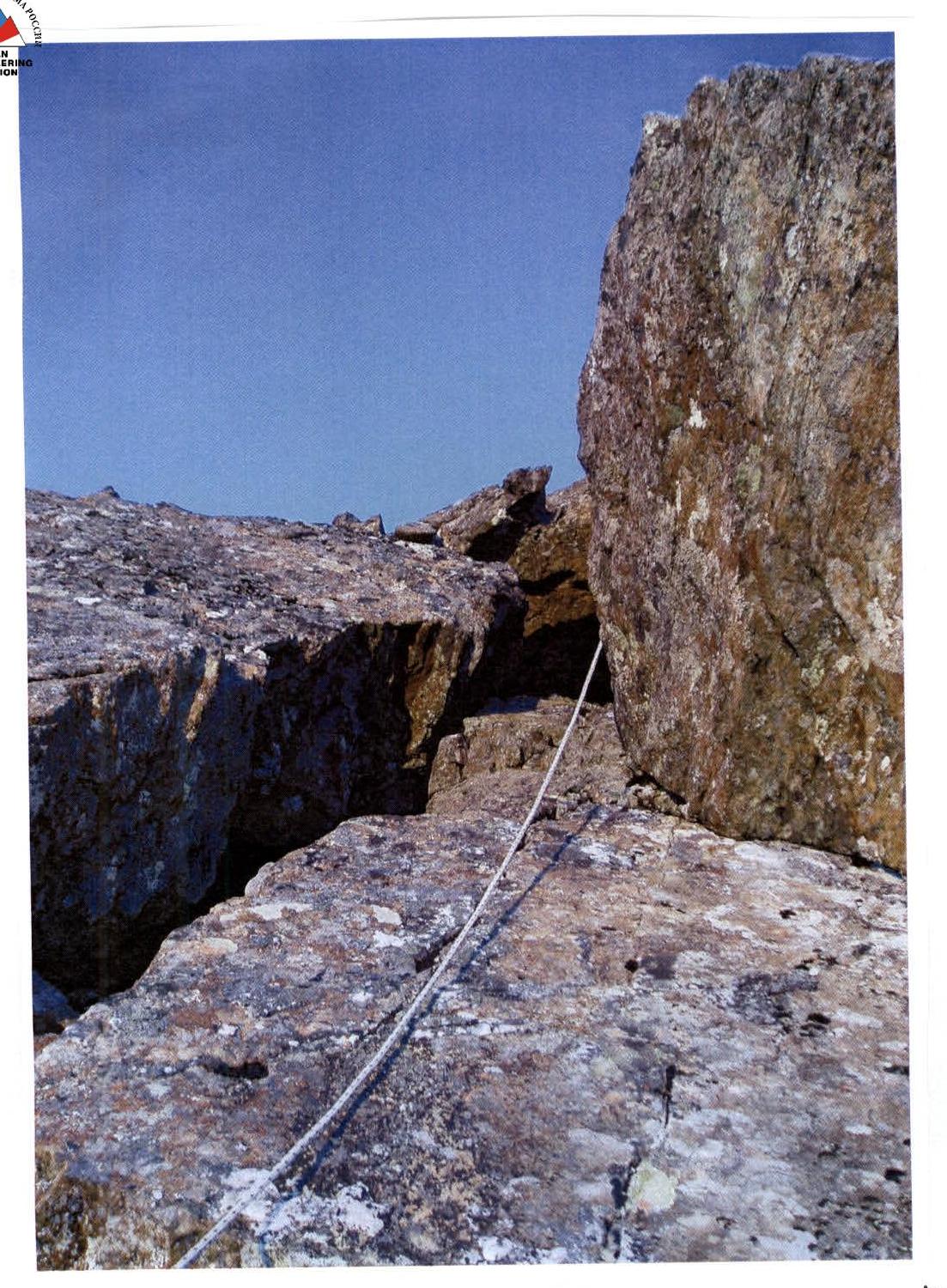
 №5. Section R8–R9 (middle of the section – second chimney)
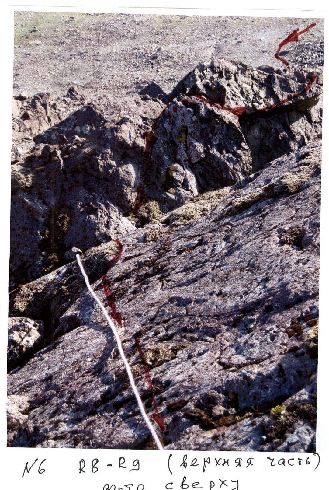
 №6. R8–R9 (upper part, photo from above)
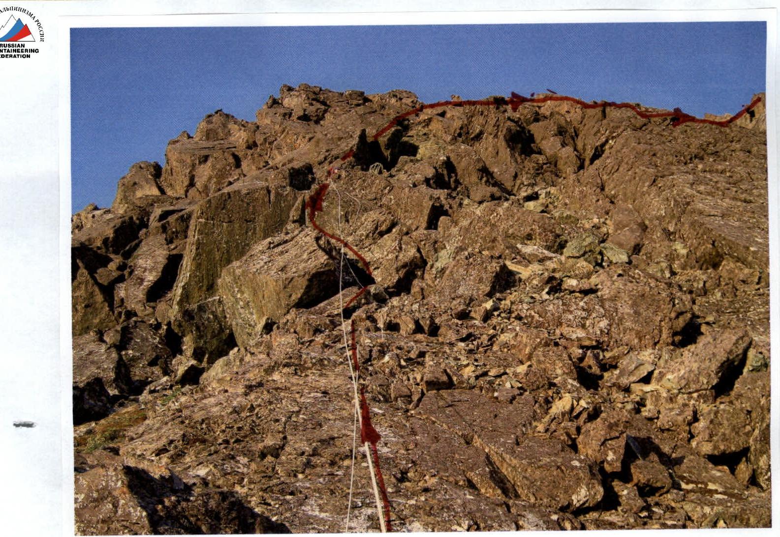
 №7. R11–R12