Passport
- Section number according to KMGV — 2010 — 8.3.58
Polar Urals, Raiiz mountain massif, Nyrdvomen-Shor stream valley.
- Name of the peak: 1159.0 (Dinozavr Glavny)
height: 1159.0 m. Route: to the eastern rocky massif of the northern wall of the western ridge («Along two rocky triangles»).
- Cat. diff.: 2B
- Route type — rocky.
- Height difference of the route: 890 m
- Route length: 3000 m
- Length of sections with the highest cat. diff.:
1st cat. diff. — 2 sections — 500 m, 2nd cat. diff. — 2 sections — 700 m, 3rd cat. diff. — 2 sections — 280 m
4th cat. diff. — 3 sections — 40 m, 5th cat. diff. — 1 section — 45 m, 6 — 0 m
- Average steepness: main part of the route — 65°.
whole route — 55°.
9. Pitons used:
Total used on the route: rock pitons — 0, chocks — 36, stationary pitons — 0, ITO — 0, removable pitons — 0. Left on the route: total — 0; including pitons — 0.
- Departure to the route — 7:00, August 9, 2006.
Reached the summit — 12:00, August 9, 2006. Returned to base camp — 14:00, August 9, 2006.
- Team's total climbing hours: 7 hours.
- Team leader: S. Maltsev (1st sports category, 2nd category instructor-methodologist, Ukhta).
Team members: E. Donyushko (2nd sports category, Ukhta).
- Coach: Zhuravlev Sergey Vasilyevich, title — CMS, 1st category instructor-methodologist.
Description of the peak
Peak 1159 (Dinozavr Glavny) — one of the peaks in the Raiiz mountain massif, located in the Yamalo-Nenets National District (YaNAO) of the Tyumen region, Ural Federal District of the Russian Federation, on the eastern slopes of the Polar Urals, northwest of the Raiiz mountain massif, in the Nyrdvomen-Shor stream valley.
Peak 1159 (Dinozavr Glavny) — a clearly defined mountain of the Raiiz massif, easily identifiable, visible from the Eletskaya station, Polar Urals station, and the 110 km halt (Polarny settlement).
The name is unofficial but has become established in the tourist and mountaineering community.
Peak 1159 (Dinozavr Glavny) is the most popular object for training ascents in the Polar Urals. Multiple routes have been laid to the peak, ranging from 1B to 4A cat. diff.
Description of the route
The route «Along the eastern rocky massif of the northern wall of the western ridge (rocky)» — a typical training route of 3A cat. diff., with a full range of natural obstacles corresponding to routes of this level.
Completing this route has not only aesthetic but also practical training significance, as it allows for the practice of techniques within the ascent:
- belaying;
- self-belaying on complex rocky terrain.
Equipment
For an ascent as part of a training group of 6 people (5 participants + instructor), the following special equipment is required on the route:
Personal:
- Standard issue
- Crampons (only in winter and off-season)
- Ice axe (only in winter and off-season)
Group:
- Main rope 10 mm — 3×50 m
- Rock hammer — 2 pcs
- Rock pitons — 16 pcs
- Ice axe — 1 pc
- Chocks — 12 pcs
- Ice screws — 0 pcs
- Quickdraws — 10 pcs
- Slings — 10 pcs
Approach
The ascent starts from the «Delta Nyrdvomen-Shora» campsite. First, cross the Nyrdvomen-Shor stream to the left bank. Then, ascend via the talus and mountain-tundra slope to the base of the eastern rocky massif (the leftmost one as you go) of the northern wall of the western ridge.
Technical part
The route begins with an ascent through a series of simple rocky ledges. Subjective rockfall danger — the ledges have small and medium-sized loose rocks.
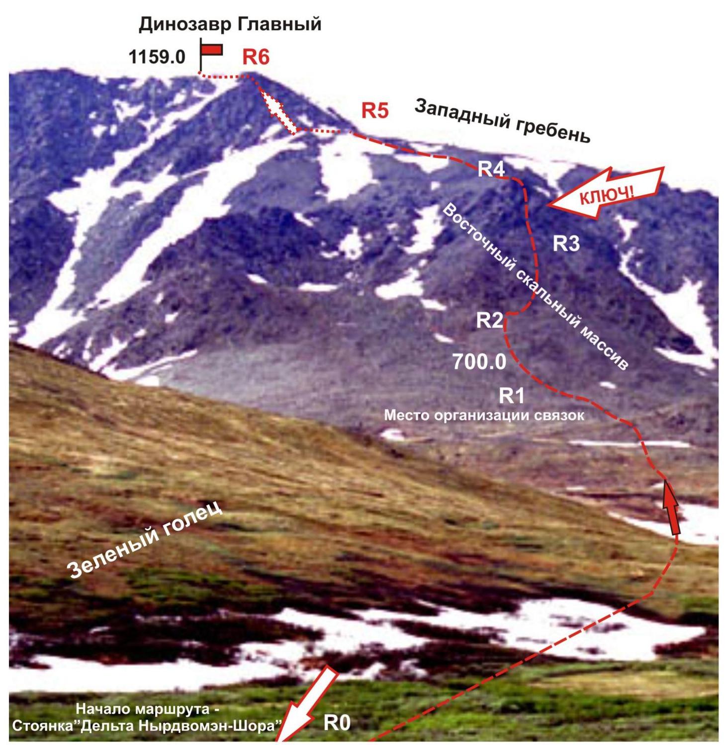
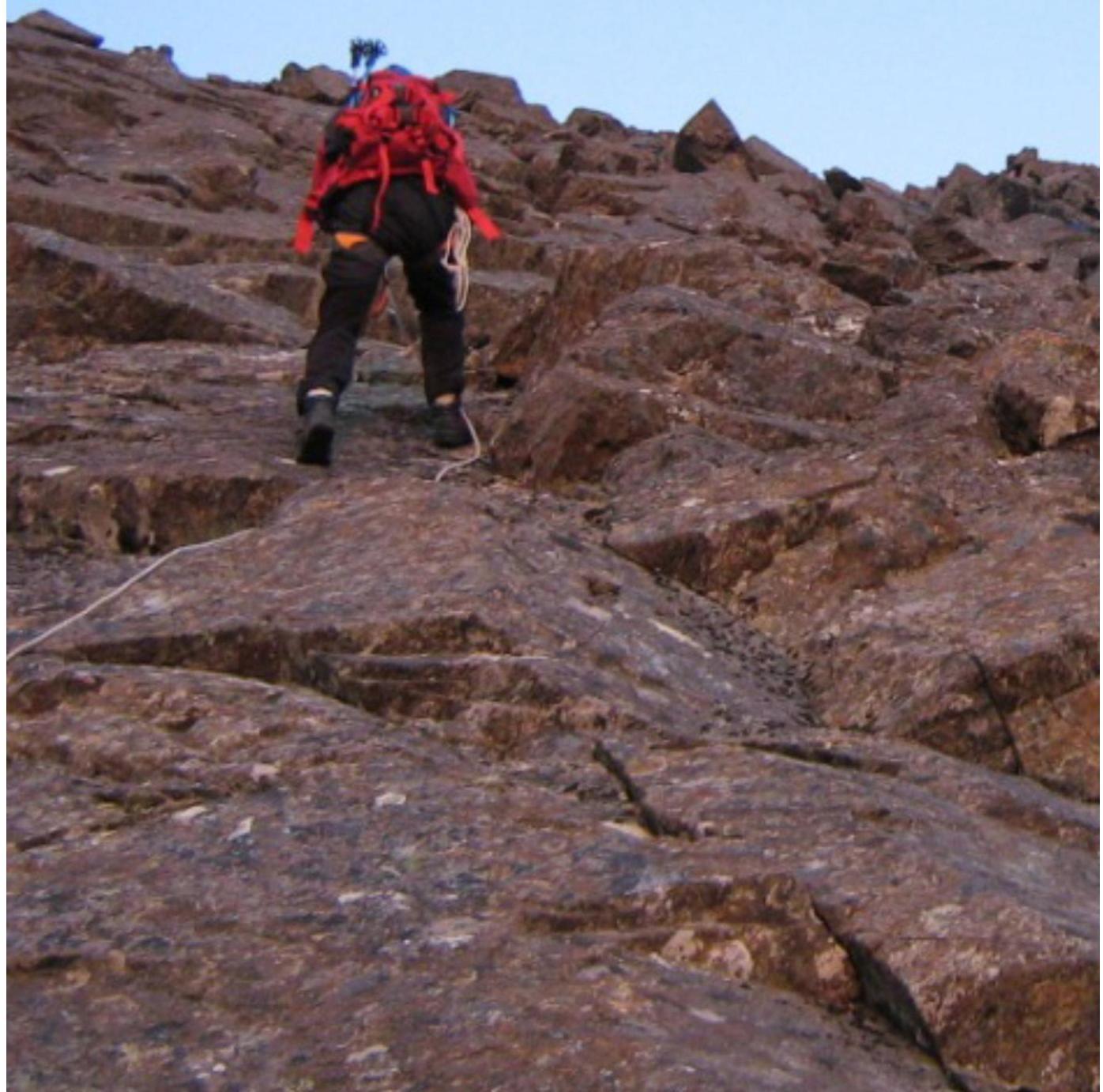
Further — exit under a weakly expressed internal angle — «Koryto». The rocks become more complex, with passive holds and smoothed surfaces. There are few places for intermediate anchors, no clear protrusions, but there are gaps for chocks (stoppers from 4 to 10 sizes).
Climb up «Koryto» to the top of the first rocky triangle under the key wall. The key wall is sloping but also lacks active relief, requiring skill in traversing rocky sections in balance and with anti-slip grips using passive holds.
Further:
- Ascend the wall to the top of the second rocky triangle.
- Continue along a relatively simple, destroyed rocky ridge to the western ridge.
- Traverse along the western ridge to the pre-summit plateau.
- From the pre-summit plateau, ascend via simple rocks and large-block talus to the summit dome.
The summit is marked with a triangulation sign.
Descent from the summit.
Descent from the summit is possible:
- along the western ridge and western couloir (1B cat. diff. route)
- via the southeastern descent couloir (non-categorical)
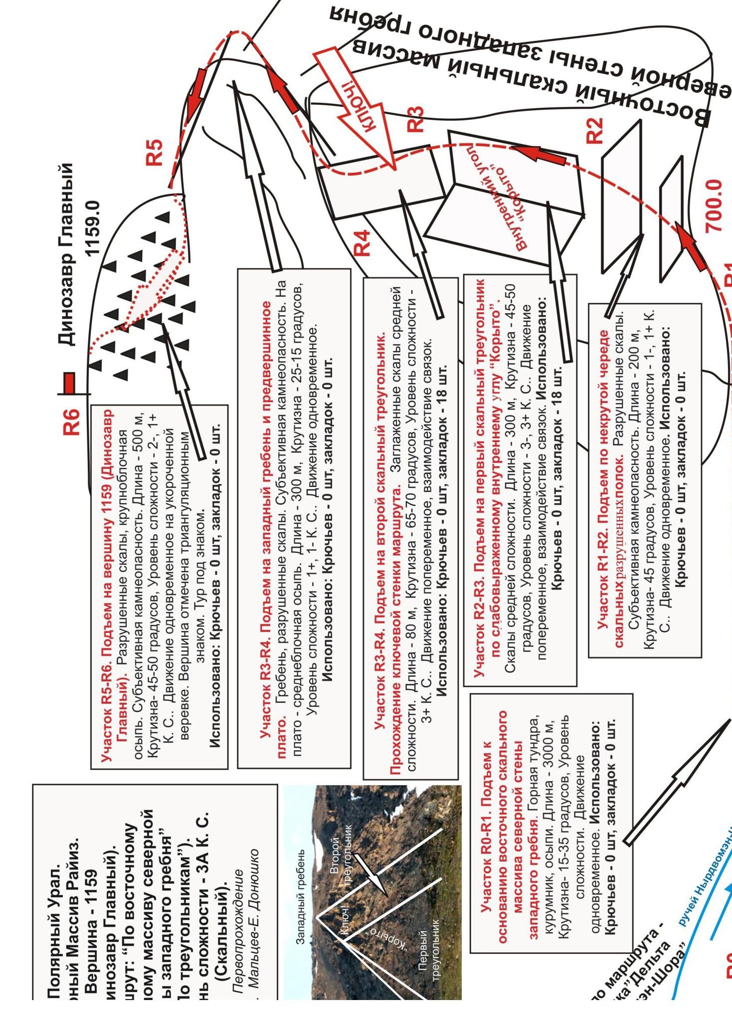
Section R2–R3. Ascent to the first rocky triangle via the weakly expressed internal angle «Koryto». Rocks of medium complexity.
- Length — 300 m
- Steepness — 45–50°
- Complexity level — 3–, 3+ cat. diff.
Movement is alternating, with rope teams. Used:
-
Pitons — 0 pcs
-
Chocks — 18 pcs. Section R1–R2. Ascent via a series of not very steep, destroyed rocky ledges. Destroyed rocks. Subjective rockfall danger.
-
Length — 200 m
-
Steepness — 45°
-
Complexity level — 1–, 1+ cat. diff.
Movement is simultaneous. Used:
- Pitons — 0 pcs
- Chocks — 0 pcs
Section R0–R1. Approach to the base of the eastern rocky massif. Slope. Mountain tundra. Talus. Length — 3000 m. Steepness — up to 40°. Complexity level — non-categorical. Movement is simultaneous. Used:
- Pitons — 0 pcs.
- Chocks — 0 pcs.
Section R1–R2. Destroyed rocky slope. Large-block talus. Destroyed rocks. Large rocky blocks.
Length of the section — 200 m. Steepness — 45°. Complexity level — 1–, 1+ cat. diff. Movement is simultaneous on a shortened rope.
Used:
- Pitons — 0 pcs.
- Chocks — 0 pcs.
Section R2–R3. Ascent to the first rocky triangle via a broad, weakly expressed internal angle — «Koryto». Destroyed rocks. Length of the section — 300 m. Steepness 45–50 degrees. Complexity level — 2+, 3- cat. diff. Movement is alternating. In some areas — organization of running belays. Used:
- Pitons — 0 pcs.,
- Chocks — 18 pcs.
Section R3–R4. Passage of the key — wall of the second rocky triangle. Smoothed monolithic rocks. Minimal number of places for intermediate belay anchors. Length — 80 m. Steepness — 65–70°. Complexity level 3B cat. diff. Used:
- Pitons — 6 pcs.
- Chocks — 8 pcs.
Section R4–R5. Exit to the western ridge and pre-summit plateau. Heavily destroyed ridge, transitioning into medium-block talus.
- Length — 300 m
- Steepness — from 35 to 15°
- Complexity level — 1+, n/c
- Movement — simultaneous on a shortened rope
- Used: pitons — 0 pcs., chocks — 0 pcs.
Polar Urals. Raiiz mountain massif. Peak — 1159 (Dinozavr Glavny). Route: «Along the eastern rocky massif» 3A (rocky). Sections:
- R1–R2
- R2–R3
Start of the route and ascent to the first rocky triangle via the internal angle «Koryto». Complexity level of the rocky sections — from 2− to 3+ cat. diff.
Section R2–R3. Ascent to the first rocky triangle via the internal angle «Koryto». Characteristic rocks: passive holds, minimal places for organization.
Section R4–R5. Ascent to the second rocky triangle. Passage of the key — sloping rocky wall. Length — 80 m.
- Holds are of passive type
- Average steepness — 55°, in some areas up to 70°
- Complexity level — 3+ cat. diff.
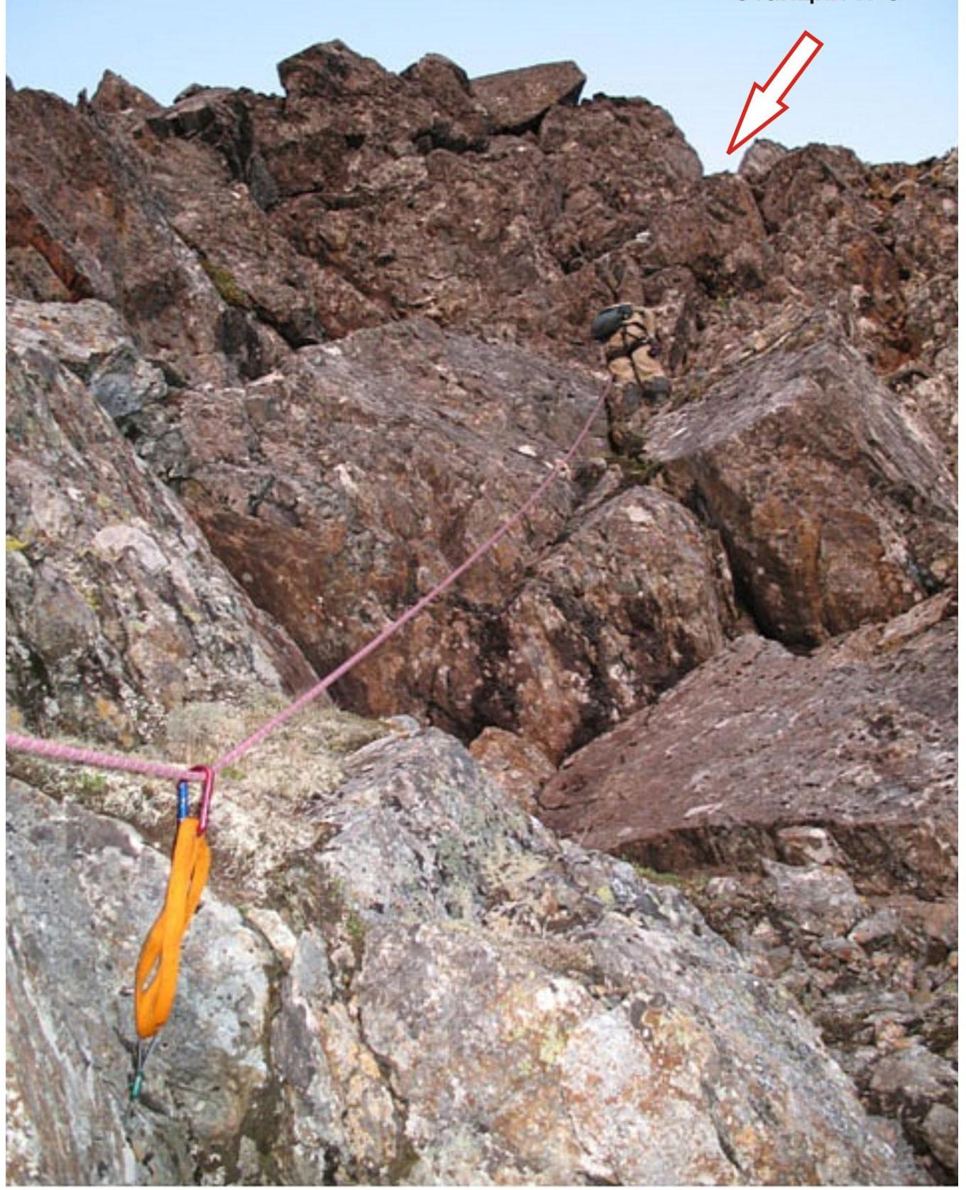
Section R3–R4. Upper part of the key wall. Exit to the top of the second rocky triangle.