Ascent Passport
Mountain region — Polar Urals Mountain range — Raiiz massif Valley — Nyrvomyn-Shor river valley Section number according to KMGV-2001 — #8.3.59 Peak name — 1060 (Dinozavr Eastern) Height — 1060 m above sea level Route name — Central counterfort of the northern wall Category of difficulty — 3A Route character — rock Height difference:
- Technical part of the route — 220 m
- Total (from base camp) — 800 m Route length:
- Technical part of the route — 300 m
- Total (from base camp) — 2000 m Technically difficult sections:
- 1st category of difficulty — 2 sections
- 2nd category of difficulty — 0 sections
- 3rd category of difficulty — 3 sections
- 4th category of difficulty — 4 sections
- 5th category of difficulty — 1 section
- 6th category of difficulty — 0 sections Average steepness of the main (technical) part of the route — 65–70° Equipment used/left on the route:
- Pitons — 19/3
- Chocks — 29/0 Team's working hours — 8 hours Team composition:
- Leader — A. A. Kremen (Candidate for Master of Sports, 1st category instructor-methodologist, Rostov-on-Don)
- Participants — M. M. Dudnikov (2nd sports category, Syktyvkar), N. D. Kondratieva (2nd sports category, Syktyvkar), Yu. V. Valuzhis (2nd sports category, Syktyvkar) Departure for the route — 7:00, June 30, 2008 Summit arrival — 15:00, June 30, 2008 Return to base camp — 19:00, June 30, 2008 Organization conducting the alpine event — Year-round alpine event Championship and primacy of the Komi Republic in alpinism, On-site stage "Alpinist Festival 'Polar Mountains — 2008'" of the Alpinism Federation of the Komi Republic, Non-profit partnership "Club of Northern Travels 'Sauk-Pai'" and the Club of Tourists and Alpinists of Ukhta Event dates — June 20 to July 5, 2008
Senior coach — releasing
FARK (Federation of Alpinism of the Komi Republic):
- F. N. Fomenko (Candidate for Master of Sports, instructor-methodologist 1st category, certification number 07, Ukhta) Senior coach — releasing for the on-site alpine event:
- S. V. Zhuravlev (Candidate for Master of Sports, instructor-methodologist 1st category, certification number 1124, Syktyvkar)
Peak Description
The peak 1060 m (Dinozavr Eastern) is located in the Raiiz mountain massif of the Polar Urals, within the Yamalo-Nenets Autonomous Okrug of the Russian Federation, beyond the Arctic Circle. It is the eastern — lower — peak of the mountain 1159 m, known by its alpinist-tourist name Dinozavr.
The peak 1060 (Dinozavr Eastern) is included in the list of classified peaks. The first routes to this peak were:
- via the southeastern slope
- via the southeastern ridge
Established by Ukhta alpinists during the winter seasons of 1995–1999. They also gave the peak its alpinist name, as it did not have an independent name.
In 2007, alpinists from the Federation of Alpinism of the Komi Republic completed two summer first ascents on peak 1060:
- via the Eastern ridge — 2B category of difficulty (rock)
- via the bastion of the Northern rib of the Eastern ridge — 3B category of difficulty
The most challenging route on peak 1060 (Dinozavr Eastern) — via the central counterfort of the Northern wall — was completed as part of the Komi Republic Championship in alpinism by a sports group of discharge holders led by A. A. Kremen (Candidate for Master of Sports, instructor-methodologist 1st sports category, Rostov-on-Don).
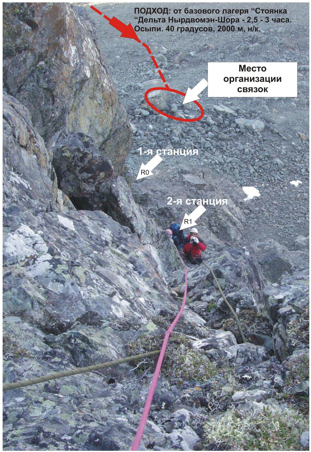
From the valley of the Nyrvomyn-Shor stream (the most convenient location for a base camp — a large larch-alder oasis in the tundra), peak 1060 m (Dinozavr Eastern) is easily recognizable as the left peak of Dinozavr, due to its pronounced rock tower and the ridges, ribs, and counterforts leading to it from different sides.
Technical description of sections for the UIAA sign scheme
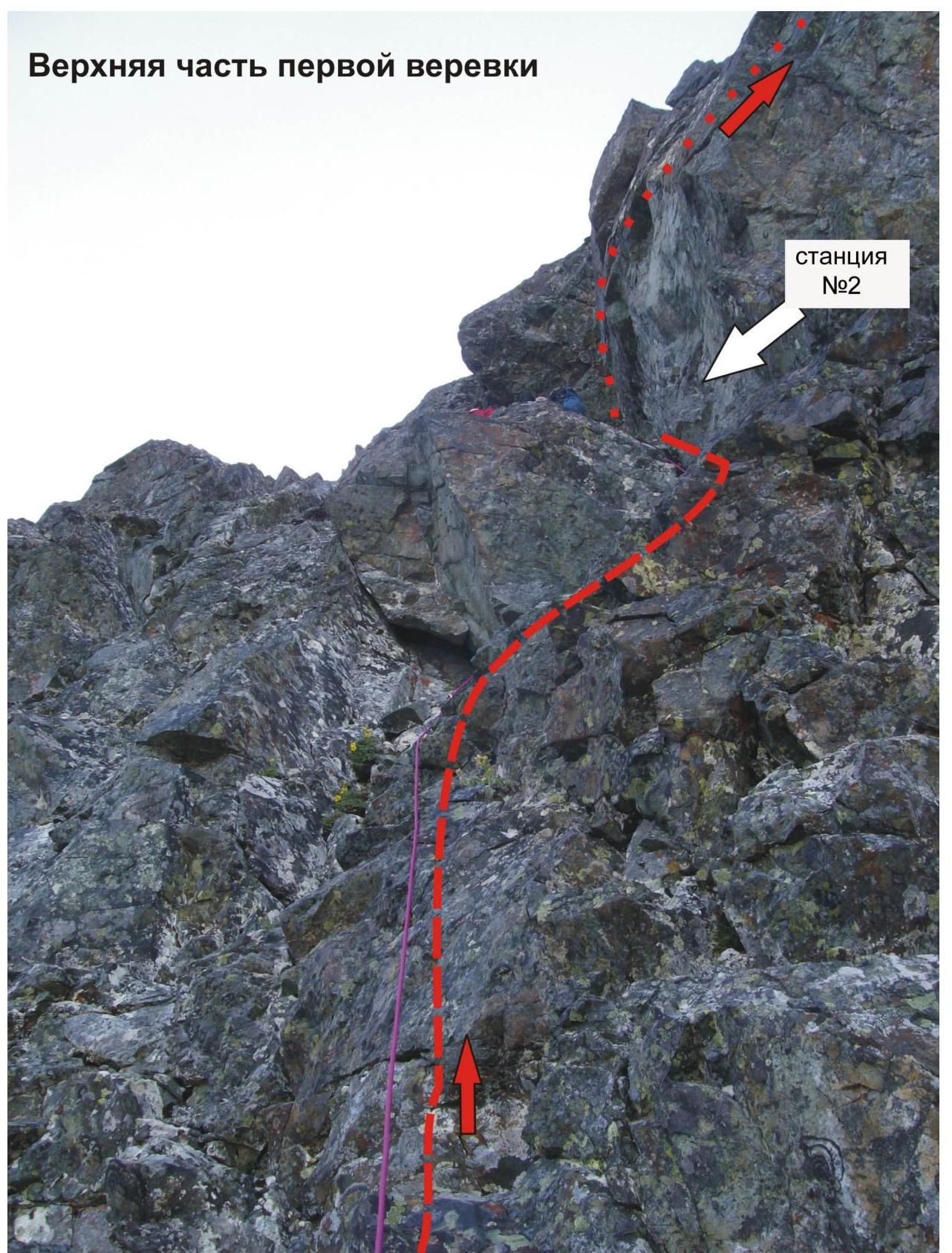
R0–R1 — Start of the route. Passage through two internal corners. At the base of the counterfort — a shelf-platform for organizing rope teams. Difficult rocks. Internal corners.
Section length — 25 m. Section steepness — 70°. Difficulty level — 4+ category of difficulty. First climber moves without a backpack, belay for the first climber on a double rope, team uses fixed ropes.
R1–R2 — Bypassing overhangs via a series of internal (difficult to climb) corners. Exit under the "Mirror" wall. Difficult rocks. Internal corners.
Section length — 25 m. Section steepness — 70°. Difficulty level — 4+ category of difficulty. First climber moves without a backpack, belay for the first climber on a double rope, team uses fixed ropes.
R2–R3 — Passage of the "Mirror" rock via an oblique traverse from right to left, passage through an internal corner and an inclined wall with an exit to a rock shelf.
Rocks:
- Traverse along mini-shelves — length — 15 m, difficulty level 4+ category of difficulty;
- Internal corner — section length — 15 m, section steepness — 55–60 degrees, difficulty level — 4- category of difficulty.
Movement with variable belay. All types of chocks and loops thrown over outcrops are actively used for intermediate belay points.
R3–R4 — Passage of a rocky wall, ascent along a rocky ridge, and exit to the shoulder of the rocky ridge of the counterfort.
Rocks. Inclined wall. Section length — 30 m. Section steepness — 60°. Difficulty level — 3B category of difficulty. Movement with variable belay. All types of chocks and loops thrown over outcrops are actively used for intermediate belay points.
R4–R5 — Passage of a rocky wall and exit to a talus shelf. Rocks. Inclined wall. Section length — 25 m. Section steepness — 55–60°. Difficulty level — 3 category of difficulty. Movement with variable belay. All types of chocks, pitons-boxes, and loops thrown over outcrops and micro-relief are used for intermediate belay points.
R5–R6 — Traverse along a talus shelf and exit to a saddle. Rocks. Traverse. Talus shelf. Section length — 25 m. Section steepness — 35°. Difficulty level — 1 category of difficulty. Simultaneous movement.
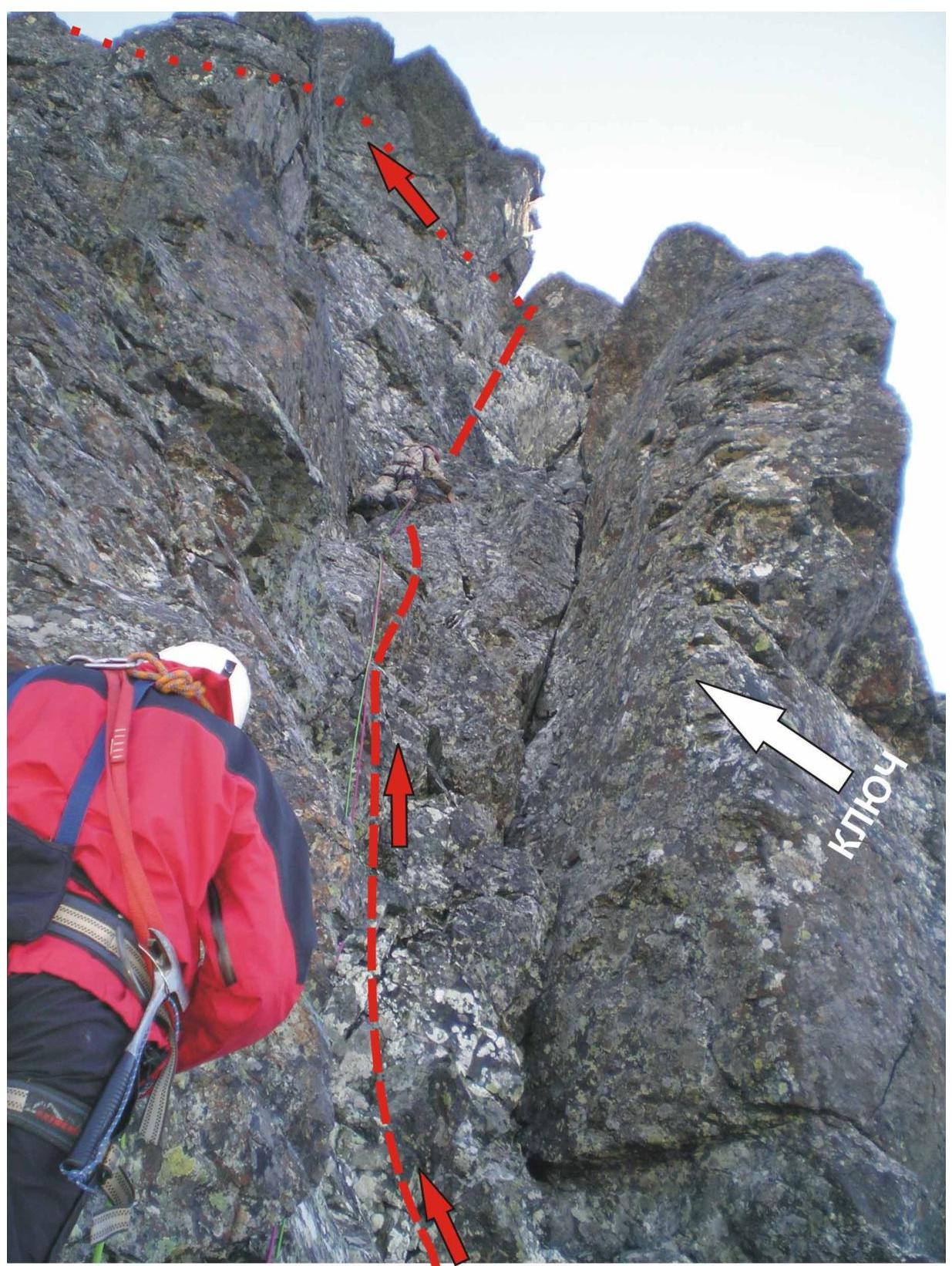
R6–R7 — Passage of the key section of the route. Bypassing overhangs on the right along difficult rocks.
Internal corner and rocky wall of increased difficulty for passage. The first climber moves without a backpack (rock shoes are desirable).
- Section length — 50 m
- Section steepness — 80°
- Difficulty level — 5B category of difficulty
- Belay for the first climber — on a double rope
- Team uses fixed ropes
- Intermediate belay points — pitons
Finding places for intermediate belay points is challenging due to the smooth internal corner and monolithic wall. Passage of the wall requires good rock-climbing skills for the leader and stable experience in organizing intermediate belay points on steep rocky massifs.
R7–R8 — Continuation of the passage of the key section of the route. Traverse under overhangs (psychologically complex section). Rocks. Traverse. Small shelves. Section length — 15 m. Section steepness — 55–60°. Difficulty level — 4+ category of difficulty. Variable movement. Exit to a talus shelf.
R8–R9 — Passage through an internal corner and exit to a talus summit ridge.
Rocks. Internal corner.
- Section length — 8 m
- Section steepness — 35°
- Difficulty level — 3– category of difficulty
- Variable movement
Exit to a talus summit ridge.
R9–R10 — Passage along a talus summit ridge. Exit to the summit. Broken rocks. Ridge.
- Section length — 25 m
- Section steepness — 15°
- Difficulty level — 1B (category of difficulty)
- Simultaneous movement
R10 — Summit 1060 (Dinozavr Eastern). A well-defined rocky tower in the ridge. Easy to find by triangulation sign.
Descent via the eastern slope, along route 1B. Talus ridge, then — couloir. Talus. Snow. Difficulty level — 1+, category of difficulty. A certain difficulty is presented by the crossing of the Nyrvomynshor river. Until mid-July, snow bridges allow crossing the stream, but later they become objectively dangerous, so it's better to use wading options.
Scheme in UIAA signs
Peak: 1060 (Dinozavr Eastern) Route: "Via the central counterfort of the northern wall"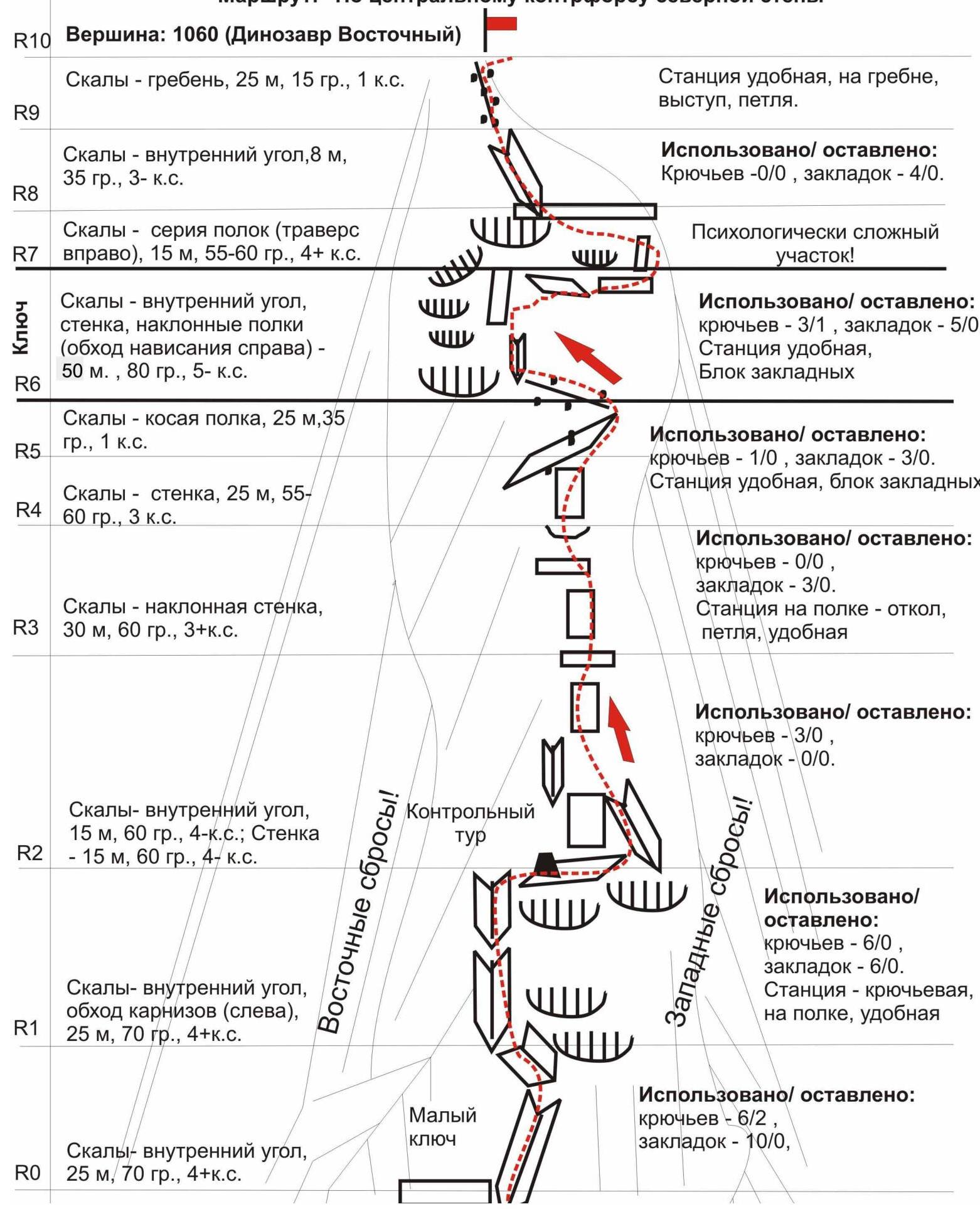
Peak 1060 (Dinozavr Eastern) Route: via the central counterfort of the northern wall Difficulty level — 4A category of difficulty. First ascent: A. Kremen + 3, 2008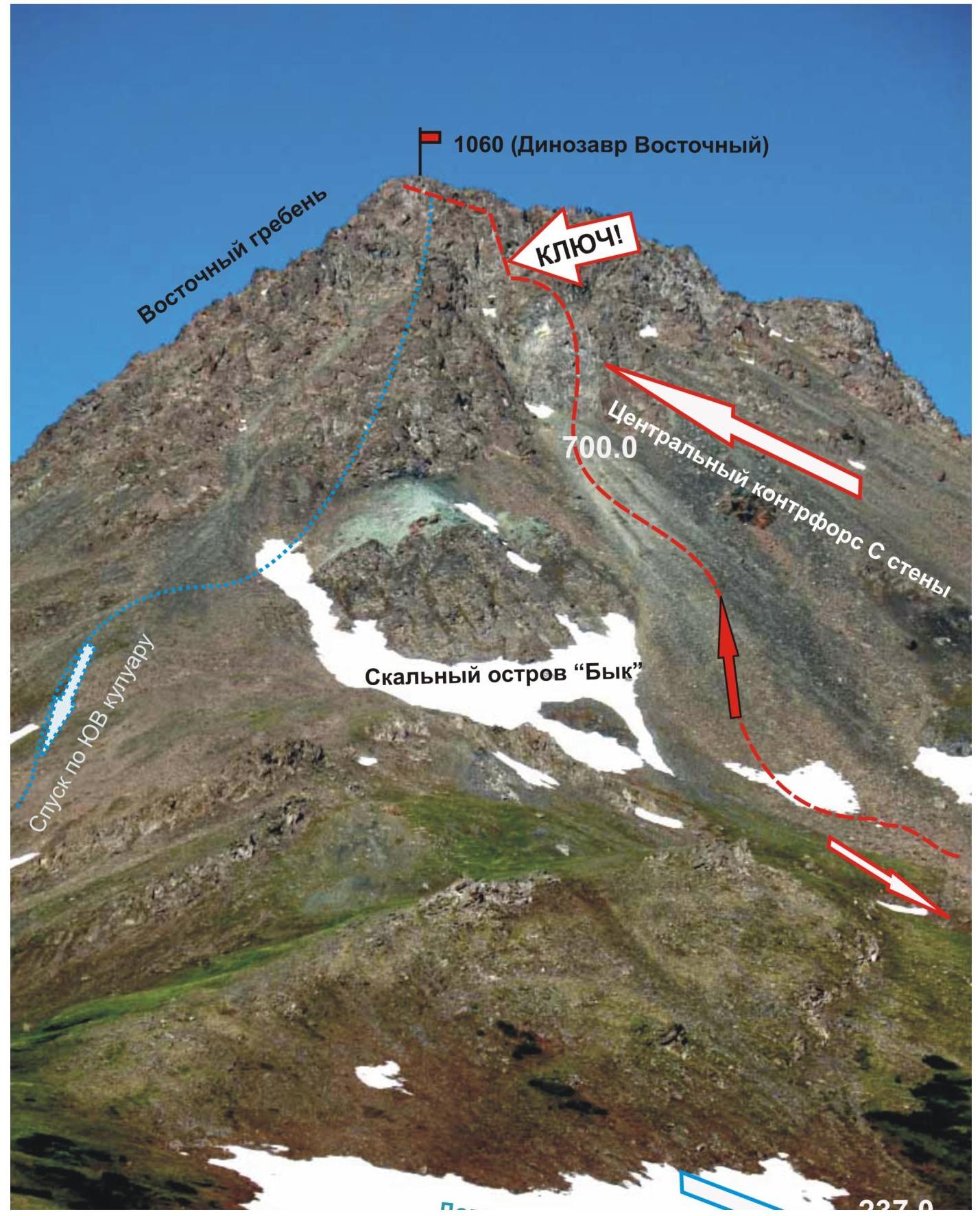
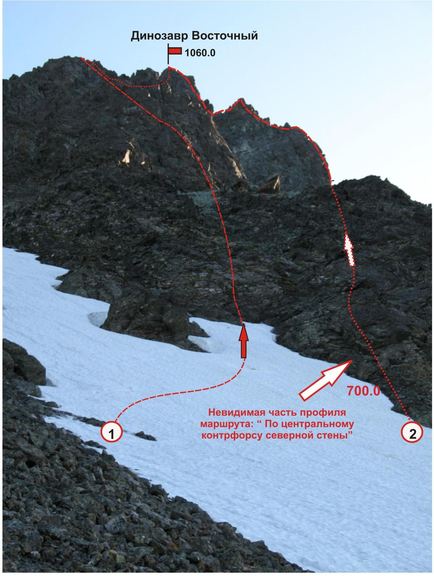
Photo-profile of peak 1060 (Dinozavr Eastern) from the east. The photo is annotated with:
- 1060.0
- Route: via the bastion of the northern rib of the eastern ridge 3B category of difficulty (rock, snow).
- 1060.0

Monolithic rocks, 50 m, steepness — 70°, — 4 category of difficulty. Outcrops and holds — passive, movement on balance. Very few cracks for chocks and pitons.
Used:
- Krasnoyarsk anchor pitons — 4
- Rock horizontal petals (VTsSPS) — 4
- Milled wedges — 6
- Chocks — stopper #3 — 2, stopper "Parus" #3 — 4. Convenient place for a belay station — a platform on a large rocky massif.
1st belay station
Profile of the upper part of the bastion of the northern counterfort. Exit to the pre-summit ridge. Photo from the summit of 1159 (Dinozavr Main)
Peak 1060 (Dinozavr Eastern). Route: via the central counterfort of the northern wall
Key section of the route:
- Monolithic rocks with a minimal minimum of micro-relief for organizing intermediate belay points
- Section length — 50 m
- Steepness — 75°
- Difficulty level — 5B, category of difficulty.
Used pitons: Krasnoyarsk anchor — 6