Polar Urals, Sob-Keu mountain ridge (Sobskie mountains). Section in KMGV — 8.3. Peak 1052 (Vorkutyanka). Route: via the eastern ridge. Difficulty category approximately 1B (winter). Leader: S. Seryakov. E-mail — mrZHUR1958@mail.RU
Report
On the first ascent of the climbing route to Peak 1052 (Vorkutyanka) via the route: "via the eastern ridge". At the year-round alpine event Cup of NP "Club of Northern Travels 'Sauk-Pai'" 2015 (class "First ascents").
Region: Ural Federal District of the Russian Federation (UFD), Yamalo-Nenets Autonomous Okrug
of Tyumen Oblast. Mountain country: Polar Urals. Valley: Sob River valley. Ridge:
Sob-Keu mountain ridge (Sobskie mountains). Peak: 1052 (Vorkutyanka). Route: "Via
the eastern ridge". Difficulty category: approximately 1B (winter). Prepared by: Seryakov
S.V., Zhuravlev S.V. November 2015. Approach on skis from Polar Urals railway station — 3
hours 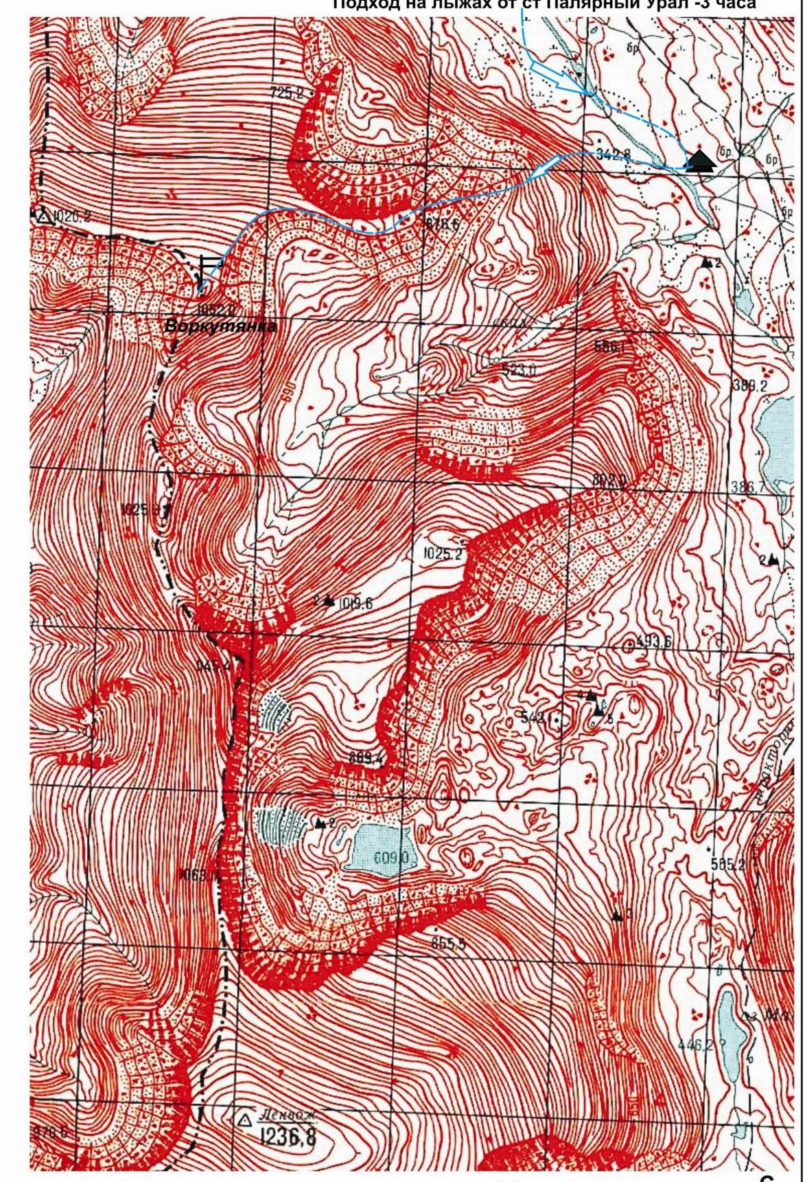
Polar Urals. Sob-Keu mountain ridge (Sobskie mountains). Peak — 1052 m (Vorkutyanka). Route: "Via the eastern ridge". Difficulty level: Approximately 1B category (Winter). Fragment of the General Staff map at 1:500,000 scale.
Description of the Sob-Keu ridge (Sobskie mountains)
The Sob-Keu mountain ridge (Sobskie mountains) is located in the main watershed ridge of the Polar Urals, on the border of:
- Europe and Asia
- Ural and North-West Federal Districts
- Yamalo-Nenets Autonomous Okrug (YaNAO) of Tyumen Oblast (eastern slopes) and the Komi Republic (western slopes)
Sob-Keu is a short meridional ridge stretching from north to south from the Sob River valley (Shlem mountains) to the Payer mountain massif. The nodal peak of the ridge is Lekvozh (1237).
Polar Urals. Sob-Keu mountain ridge (Sobskie mountains). Peak 1052 (Vorkutyanka).
Route: "Via the eastern ridge". Difficulty category — 1B (winter)
Passport
- Section number in KMGV —
Polar Urals, Sobsky mountain massif.
- Name of the peak: Peak 1052 (Vorkutyanka).
- Height: 1052 m.
- Route: "Via the eastern ridge".
- Difficulty category: approximately 1B (winter). K. S.
- Nature of the route — snow-ice (winter).
- Height difference of the route: 750 m
- Length of the route: 1550 m
- Length of sections with the highest difficulty category:
category 1B — 3 sections — 1300 m, category 2A — 0 sections — 0 m, category 3A — 0 sections — 0 meters.
- Average steepness: — 30°.
- Number of pitons used:
Total used on the route:
- rock pitons — 0 pcs
- chocks — 0 pcs
- stationary pitons — 0
- ITI — 0
- removable pitons — 0
Left on the route: total — 0 pcs; including pitons — 0.
- Departure for the route — 6:30, August 12, 2015.
Reached the summit — 12:00, November 12, 2015. Returned to the base camp — 14:00, November 12, 2015.
- Team's total climbing hours: — 6 hours.
- Leader: S. Seryakov (Vorkuta, 3rd sports category).
Participants:
- N. Gryaznov (Vorkuta, 3rd sports category)
- R. Lakomy (Vorkuta, 3rd sports category)
- A. Kabanov (Vorkuta, 3rd sports category)
- S. Salnikov (Vorkuta, 3rd sports category)
- V. Mayer (Vorkuta, 3rd sports category)
- Coach: Zhuravlev Sergey Vasilyevich, (CMS, instructor-methodologist 1st category,
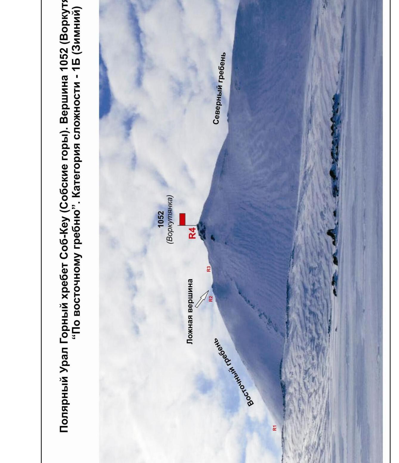
Syktyvkar). Polar Urals. Sob-Keu mountain ridge (Sobskie mountains). Peak —
1052 m (Vorkutyanka). Route: "Via the eastern ridge". Difficulty level:
approximately 1B category (winter). Technical photo of the summit and profile.
Photo from the Sob River valley. November 2015
g.
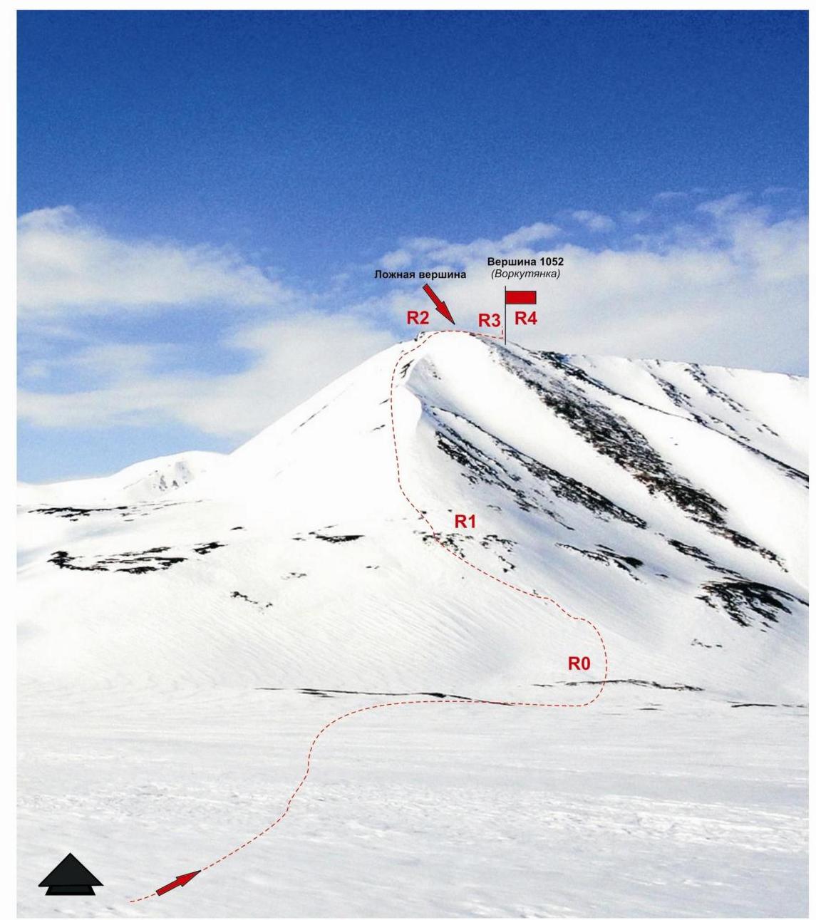
Section R0–R1. Ascent to the beginning of the ridge. Snow slope turning into a ridge. Length — 250 m. Steepness 15°. Difficulty level — non-categorized.
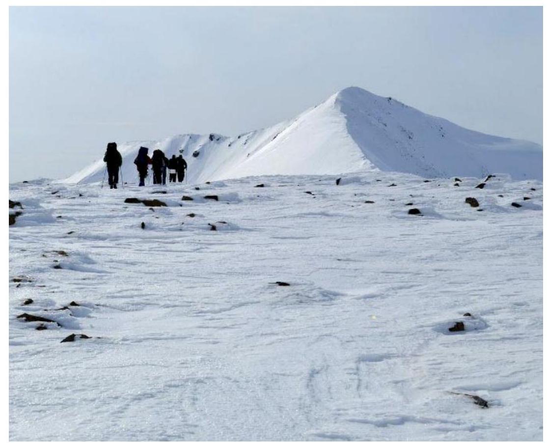
Section R1–R2. Ascent to the false summit. Snow ridge. Length — 450 m, steepness — up to 30°. Difficulty level — 1 category.
Section R2–R3. Traverse along the col to the pre-summit ridge. Snow ridge. Length — 350 m. Steepness — up to 45°. Difficulty level — 1 category.
Section R3–R4. Ascent to Peak 1052 (Vorkutyanka). Snow ridge. Length — 500 m. Steepness — up to 45°. Difficulty level — 1+ category.
Description of the peak.
Peak 1052 (Vorkutyanka) — is located in the northern part of the Sob-Keu ridge (Sobskie mountains) on the border of:
- Yamalo-Nenets Autonomous Okrug (YaNAO) of Tyumen Oblast
- Komi Republic
in the upper reaches of the Sob River, Ural Federal District of the Russian Federation.
Peak 1052 (Vorkutyanka) — a clearly expressed mountain, easily identifiable from the west and east, located in the main watershed ridge of the Polar Urals. The name is not indicated on the General Staff map, given by climbers from Vorkuta and serves for peak identification.
Description of the route.
The route "Via the eastern ridge" — is a training snow-ice route of 1B (winter) category, with a set of natural obstacles. Climbing this route has practical training and sports significance, as it allows to practice within the ascent:
- belaying techniques;
- self-belaying techniques on a snow ridge.
Equipment.
For the ascent, a team of 6 people (5 participants + instructor) in a training and sports group needs the following special equipment:
- Personal — standard, including crampons and ice axe
- Group — main rope 10 mm — 2×50 m
Approach.
The ascent starts from a campsite in the upper reaches of the Sob River, at the foot of an unnamed mountain of the Sobsky ridge with a height mark of 1025.
Approach to the campsite: from the Polar Urals railway station, go upstream along the left bank of the Sob River to the foot of the 1025 peak (3.5 hours from the station).
Technical part.
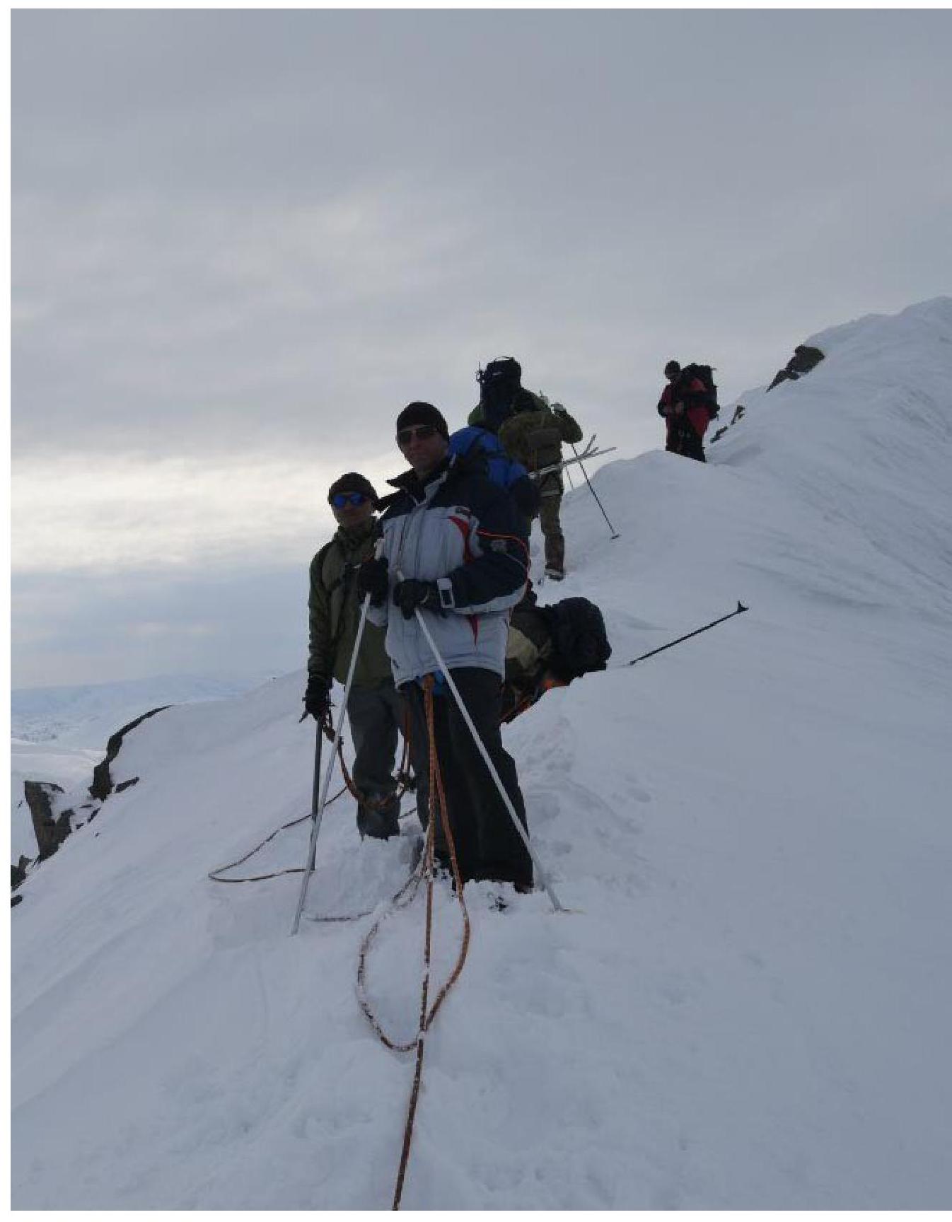
The technical part of the route starts 100 m from the base camp. The slope is 15°, then an exit to a snow ridge with a steepness of up to 30°. Further, the ridge becomes steeper up to 45° and narrows. Movement along the ridge upwards in teams with simultaneous belaying to a small col. From the col, a ridge begins, leading to the summit.
Crux of the route.
Passing the pre-summit ridge — the crux of the route. The snow is dense, movement in crampons, in teams, with occasional step cutting. Ridge steepness is 30°.
Summit.
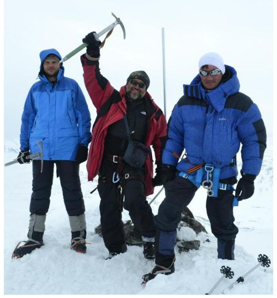
Dome-shaped. On the summit — a geodetic benchmark. The summit area allows a group of 10–15 people to gather.
Descent.
Descend south to the Lekvozhsky Severny pass. On the pass — unrope, then descend along the valley of an unnamed tributary to the base camp in the Sob River valley.
If fresh snow falls, this descent is avalanche-prone, so during snowfalls it is recommended:
- to descend via the ascent route.
Recommendations for the instructor
The route is within the standard framework of a traditional 1B category route, and can be used for training groups NP-1,2, as a qualifying ascent. Polar Urals. Sob-Keu mountain ridge (Sobskie mountains). Peak — 1052 (Vorkutyanka). Route: "Via the eastern ridge". Difficulty level: approximately 1B category (winter).
Scheme in UIAA symbols 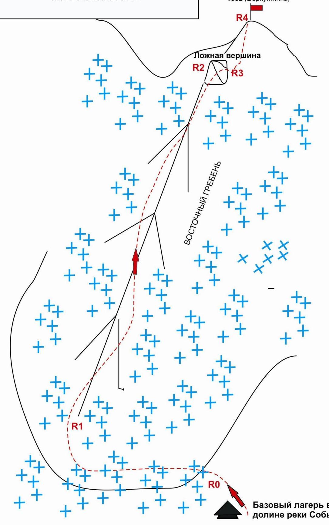
Polar Urals. Sob-Keu mountain massif
Peak: 1052 (Vorkutyanka) Route: "Via the eastern ridge" Difficulty level: approximately 1B (winter) category (table of natural obstacles on the route)
| Section | Length | Steepness | Terrain character | Category | Number of pitons/chocks |
|---|---|---|---|---|---|
| Approach | From the base camp in the upper reaches of the Sob River — 10 min. Along a snow slope of 10–15 degrees. | ||||
| R0–R1 Ascent along the snow slope to the foot. | 250 | 15 | Snow. | N/C. | Used 0/0 Left 0/0 |
| R1–R2 Ascent along the snow ridge to the false summit. | 450 | 30 | Snow. | 1 | Used 0/0 Left 0/0 |
| R2–R3 Traverse along the col and ascent to the pre-summit snow ridge | 350 | 45 | Snow. | 1 | Used 0/0 Left 0/0 |
| R3–R4 Exit to Peak 1052. | 500 | 45 | Snow. | 1 | Used 0/0 Left 0/0 |
| Descent | Via the ascent route or descend south to the Lekvozhsky Severny pass, then to the valley. (Descent via the pass is avalanche-prone with abundant fresh snow!) |
Total
Route length — 1550 m. Average steepness — 30°
Terrain character — snow.
Technical sections:
- 1 category — 3 sections — 1300 m
- 2 category — 0 sections — 0 m
- 3 category — 0 sections — 0 m
- 4 category — 0 sections — 0 m
- 5 category — 0 sections — 0 m
- 6 category — 0 sections — 0 m
Pitons and chocks used: 0/0 pcs.
Pitons and chocks left: 0/0 pcs.