Barkova northwest peak (1186.5)
Route: via the 1st buttress of the northern slope
Complexity category: approximately 2Acl
Leader: Goletarov A. A.
Subpolar Urals, Rosomakha mountain range
Section in KMSR – 8.3
E-mail: mr.zhur1958@mail.ru
Report
On the first ascent of the mountaineering route to the peak Gora Barkova northwest (1186.5) via the route: "Via the 1st buttress of the northern slope"
Complexity level — approximately 2A category (rocky) at the alpinist event "Severnaya Vertikal" (joint project of JSC "Severgaztrans" and NP "Club of Northern Travels "Sauk-Pai" 2016) (Class "First Ascents").
Region: Northwestern Federal District of the Russian Federation, Komi Republic
Mountain country: Subpolar Urals
Gorge: Bolbanyu River valley
Range: Rosomakha
Peak: Barkova northwest (1186.5)
Route: via the 1st buttress of the northern slope
Complexity category: approximately 2A category
Route type: rocky
Prepared by: Goletarov A. A., Zhuravlev S. V.
March 2016
Passport
- Section number according to KMSR – 2010 – 8.3.
Subpolar Urals, Rosomakha mountain range, Bolbanyu River valley.
- Name of the peak: Barkova (Northwest)
Height: 1186.5
-
Route: via the 1st buttress of the northern slope.
-
Complexity category: proposed 2A category.
-
Route type — rocky.
-
Height difference of the route: 530 m
-
Route length: 1000 m
-
Length and complexity level of technical sections:
Technical sections:
- 1st category — 2 sections – 450 m
- 2nd category — 3 sections – 400 m
- 3rd category — 1 section – 40 m
- 4th category — 0 sections – 0 m
- 5th category — 0 sections – 0 m
- 6th category — 0 sections – 0 m.
-
Average steepness: main part of the route – 30°, crux – 65°.
-
Pitons used:
Total pitons used on the route: rock pitons — 4 pcs., stoppers — 28 pcs., stationary pitons — 0, ITO — 0, removable pitons — 0. "Pitons" left on the route: total – 0; including pitons — 0.
- Approach to the route – 8:00, April 3, 2016.
Reached the summit – 15:30, April 3, 2016.
Returned to base camp – 19:00, April 3, 2016.
-
Team's total climbing hours: — 11 hours.
-
Leader: Goletarov A. A.
Participants: V. Eskov, A. Likhomanov, V. Schastlivtsev
- Coach: Zhuravlev Sergei Vasilyevich (Syktyvkar, Candidate Master of Sports, 1st category instructor-methodologist).
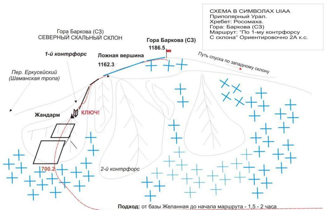
Description of the peak
Gora Barkova is one of the peaks of the Rosomakha mountain range, located in the Northwestern Federal District of the Russian Federation, in the Komi Republic, within the territory of the Municipal Formation "City District Inta". Geographically — in the central part of the Rosomakha range of the Subpolar Urals, in the Bolbanyu River valley. Gora Barkova is a mesa with two peaks marked on the map-kilometer grid of the Russian General Staff.
The main peak of Gora Barkova is a dome-shaped elevation on the vast plateau of the mesa. The name of the mountain is official, given in honor of the famous Russian geographer A. S. Barkov, marked on all state maps of the Russian Federation, including the map-kilometer grid of the Russian General Staff.
The northwest peak of Gora Barkova (without an official name) is a destroyed, scree-covered dome, to which rocky buttresses lead from the north, northwest, and west, and on the east, a gentle slope, after a slight depression (–100 m), turns into the plateau of the main peak.
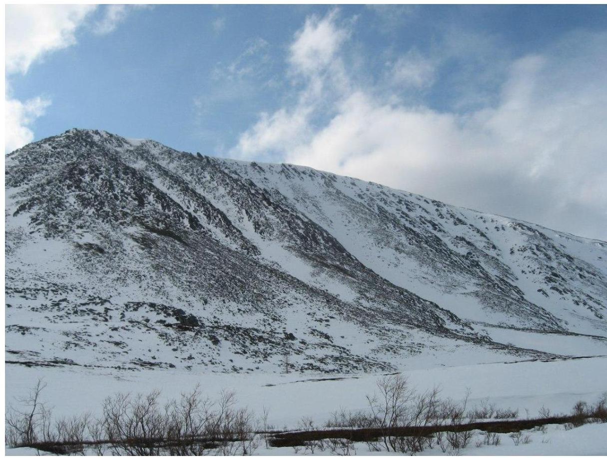
The height of the main peak of Gora Barkova is 1320.8 m, the northwest peak is 1186.5 m.
(In the photo — northwest peak, photo-profile from the northwest from the Bolbanyu River valley. March 2016).
The heights are marked on the map-kilometer grid of the Russian General Staff.
The mountaineering interest on the main peak of Gora Barkova is represented by routes:
- from the valley of the Kamenisty stream along the rocky slope of the western cirque;
- along the rocky buttresses leading to the northwest peak of Gora Barkova from the south;
- along the rocky buttresses leading to the northwest peak of Gora Barkova from the north.
As part of the "Severnaya Vertikal" mountaineering event, the following routes were traversed and classified:
- Barkova Main – "Via the central couloir of the western slope" — approximately 1Bcl (snow-ice).
- Barkova (NW) – "Via the southwest ridge" — approximately 1Bcl (rocky).
- Barkova (NW) – "Via the 1st buttress of the northern slope" — approximately 2A cl (rocky)
- Barkova (NW) – "Via the 2nd buttress of the northern slope" — approximately 2B cl (rocky).
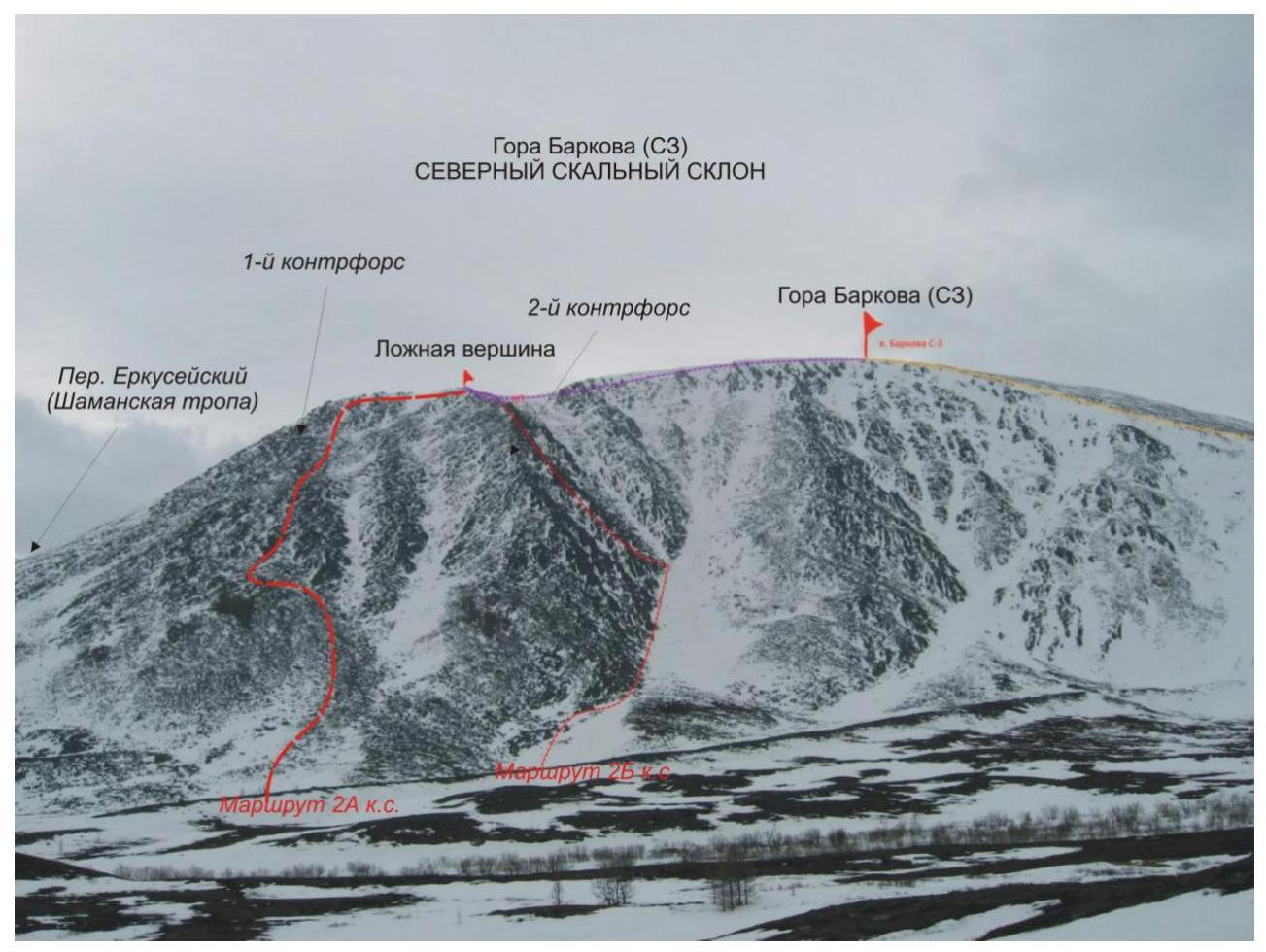
Overview photo of the northern slope of the northwest peak of Gora Barkova with a sketch of the developed routes.
Description of the route: Gora Barkova (NW) "Via the 1st buttress of the northern slope" — approximately 2A cl (rocky)
Route: "Via the 1st buttress of the northern slope" — a logical, rocky route, oriented towards educational and sports divisions of mountaineers undergoing training under the Initial Training second-year program — IT-2. The route allows for full development of movement techniques on rocky terrain, as well as belaying and self-belaying techniques. The route is logical in orientation, the line follows the rocky ridge of the pronounced buttress. The route is objectively safe.
Equipment
For the ascent as part of a sports group of 6 people on the route, the following special equipment is required:
Personal — standard (crampons and ice axe mandatory in winter).
Group equipment:
- main rope 10 mm — 2 pcs. x 50 m.
- stoppers — 12 pcs.
- quickdraws — 8 pcs.
- slings — 6 pcs.
- rock pitons — 4 pcs.
- rock hammer — 1 pc.
- ice axe — 1 pc.
Approach
From the Zelannaya base, go downstream along the Bolbanyu River on the right bank to the gully leading to the Erkueysky pass (Shaman Trail) between the peaks Erkusei and Gora Barkova.
Then:
- Up the gully to the base of the first (left) rocky buttress of the northern slope of Gora Barkova.
- At the base of the buttress, organize rope teams.
Technical part
After organizing rope teams, ascend via the несложным скальным плитам onto the ridge of the buttress. Movement with alternating belays, with belay points on outcrops, in some cases — using stoppers. The rocky terrain consists of stepped slabs.
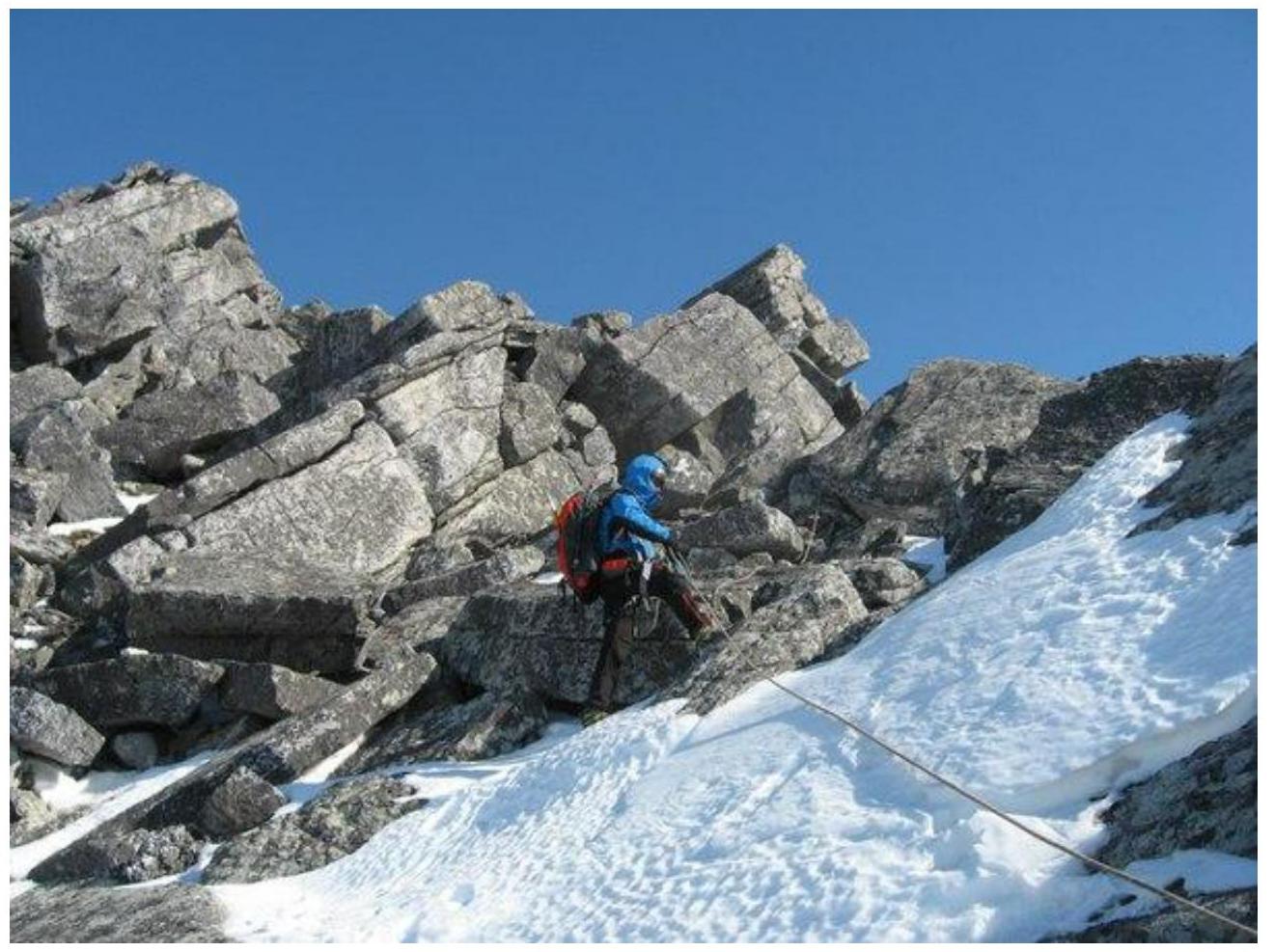
Further main landmark — the "Knight" gendarme (see photo below) — a gendarme resembling a chess knight. The ridge becomes narrower but is still formed from inclined slabs with numerous large horizontal cracks, crevices, and fissures. From the "Knight" gendarme, a jagged rocky ridge follows. The passage along the ridge is the crux of the route.
In the photo: rocky slabs at the beginning of the route
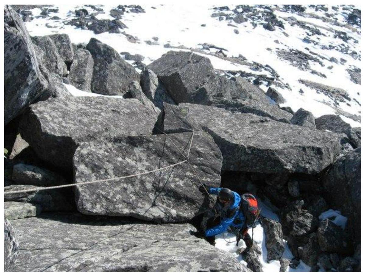
In the photo: rocky slabs at the beginning of the route
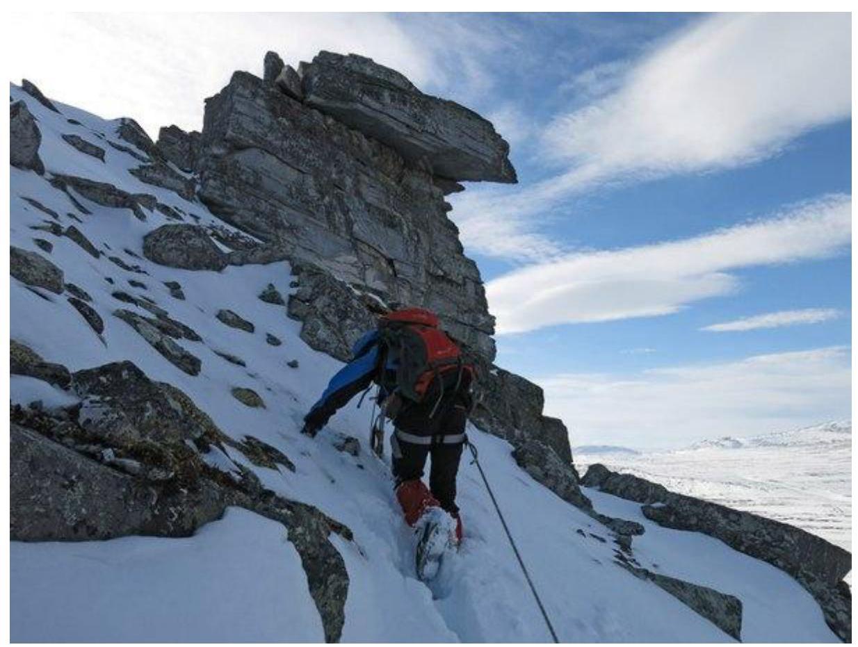
In the photo: characteristic landmark on the ridge – "Knight" gendarme.
Crux: Ascending to the ridge from the "Knight" gendarme via the inner corner — the most challenging part of the crux.
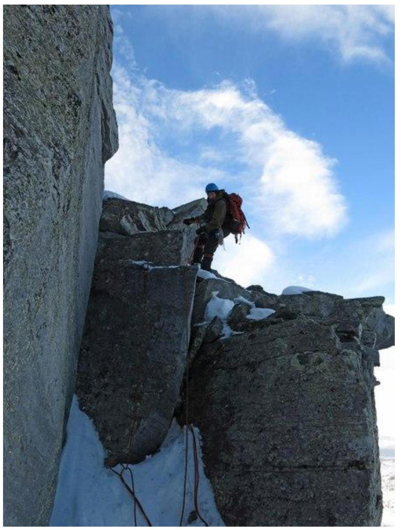
In the photo: Passage of the upper part of the crux — the inner corner when exiting onto the rocky ridge.
After passing the crux:
- Reach the sub-summit (where the buttress meets the northern ridge).
- Then, ascend a несложному осыпному заснеженному склону to the false summit.
- Followed by a несложный подъём onto the scree-covered dome of the northwest peak of Gora Barkova.
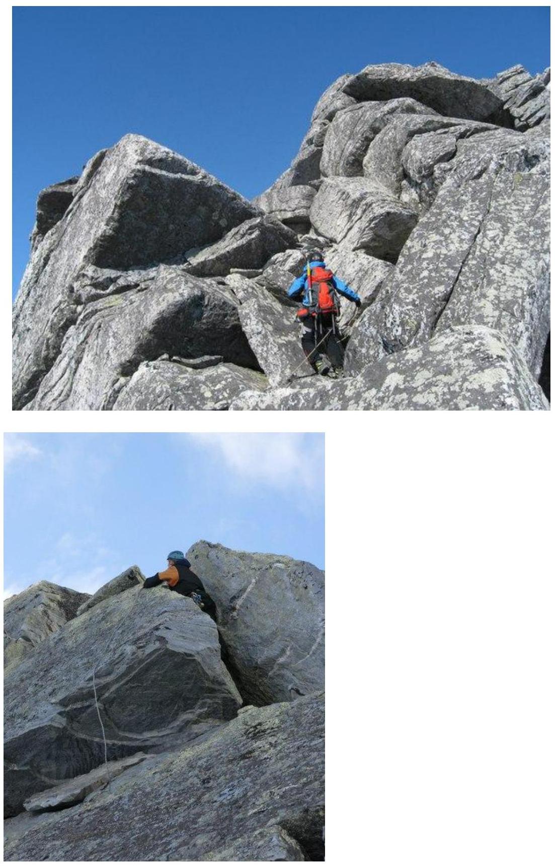
In the photo: characteristic stepped rocky formations on the ridge.
Summit
The summit is a dome with a jumble of large stone blocks. On the summit, a benchmark sign of the Russian geodetic network is installed.
Descent from the summit
Descend via the non-categorized western slope into the Bolbanyu River valley, then, after descending into the valley:
- return upstream to the Zelannaya base.
Classified analogs of the route in other mountain regions
- Kaydzhany (N) from the east – 2Acl (North Ossetia. Kaydzhany mountain massif).
- Takhtarvumchorr (S) – 2Acl (Kola Peninsula, Khibiny tundras).
Subpolar Urals. Bolbanyu valley.
Peak: Gora Barkova northwest (1186.5).
Route: "Via the 1st buttress of the northern slope".
Complexity level: 2A cl (rocky) approximately.
Table of natural obstacles.
| Section | Length (m) | Steepness | Terrain characteristics | Climbing category | Number of Pitons/stoppers (pcs.) |
|---|---|---|---|---|---|
| APPROACH | From the "Zhelannaya" base along the Bolbanyu River valley to the gully leading to the pass between v. Erkusei and Gora Barkova (NW). Then along the gully to the base of the first rocky buttress of the northern slope, to the start of the route – 1.5 hours | ||||
| R0 | Base of the buttress. Central part. Rocky terrace at the base — a convenient place for organizing rope teams. | ||||
| R0–R1 | 350 m | 25–30° | Dense rocks. Stepped slope composed of large slabs. | 1–2 | 0 / 0 |
| R1–R2 | 50 m | 60° | Monolithic rocks, Inner corner | 2+ | 0 / 3 |
| R2–R3 | 200 m | 65° | Rocky ridge. Dense monolithic rocks. Steps up to 5–10 m. | 2–, 2+ | 2 / 8 |
| R3–R4 | 200 m | 35° | Destroyed scree-covered snow slope | 1 | 0 / 0 |
| R4–R5 | 150 m | 35° | Destroyed scree-covered snow slope | 1 | 0 / 0 |
| R6 | The summit is marked by a jumble of large stones. Accommodation for the climbing group is not a problem | ||||
| DESCENT | Descent via the non-categorized western slope to the Zhelannaya base. |
Summary
Route length – 950 m.
Height difference – 500 m.
Average steepness of the entire route — 40°, crux – 70°.
Terrain characteristics — rocky.
Technical sections:
- 1st category — 2 sections – 350 m
- 2nd category — 3 sections – 600 m
- 3rd category — 0 sections – 0 m
- 4th category — 0 sections – 0 m
- 5th category — 0 sections – 0 m
- 6th category — 0 sections – 0 m
Pitons and stoppers used: 2/11 pcs.
Pitons and stoppers left: 0/0 pcs.
UIAA symbol scheme