
Report
On the first ascent
of Hacettepe peak (3214 m) via SW wall, category 5B (proposed) by a team from St. Petersburg from May 9, 2023, to May 10, 2023.
Ascent Passport
| 1. General Information | ||
|---|---|---|
| 1.1 | Full name, sports rank of the leader | Andrei Olegovich Panov, Master of Sports |
| 1.2 | Full name, sports rank of participants | Alexander Alekseevich Tsytsarev, 1st sports rank, Oksana Andreevna Kochubey, Candidate for Master of Sports |
| 1.3 | Full name of coach | Vladimir Alexandrovich Molodozhen, Tatyana Ivanovna Timoshenko |
| 1.4 | Organization | RSFO Federation of Alpinism of St. Petersburg |
| 2. Characteristics of the ascent object | ||
| 2.1 | Region | 12. Peaks of different countries 12.12 Others |
| 2.2 | Valley | Cimbar Vadisi |
| 2.3 | Number of section according to the electronic Russian classifier of routes to mountain peaks | 12.12 |
| 2.4 | Name and height of the peak | Hacettepe Peak (3214 m) |
| 2.5 | Geographic coordinates of the peak (latitude/longitude), GPS coordinates | N 37.85854° E 35.16214° |
| 3. Characteristics of the route | ||
| 3.1 | Route name | via SW wall |
| 3.2 | Proposed category | 5B |
| 3.3 | Degree of route exploration | first ascent |
| 3.4 | Nature of route terrain | rocky |
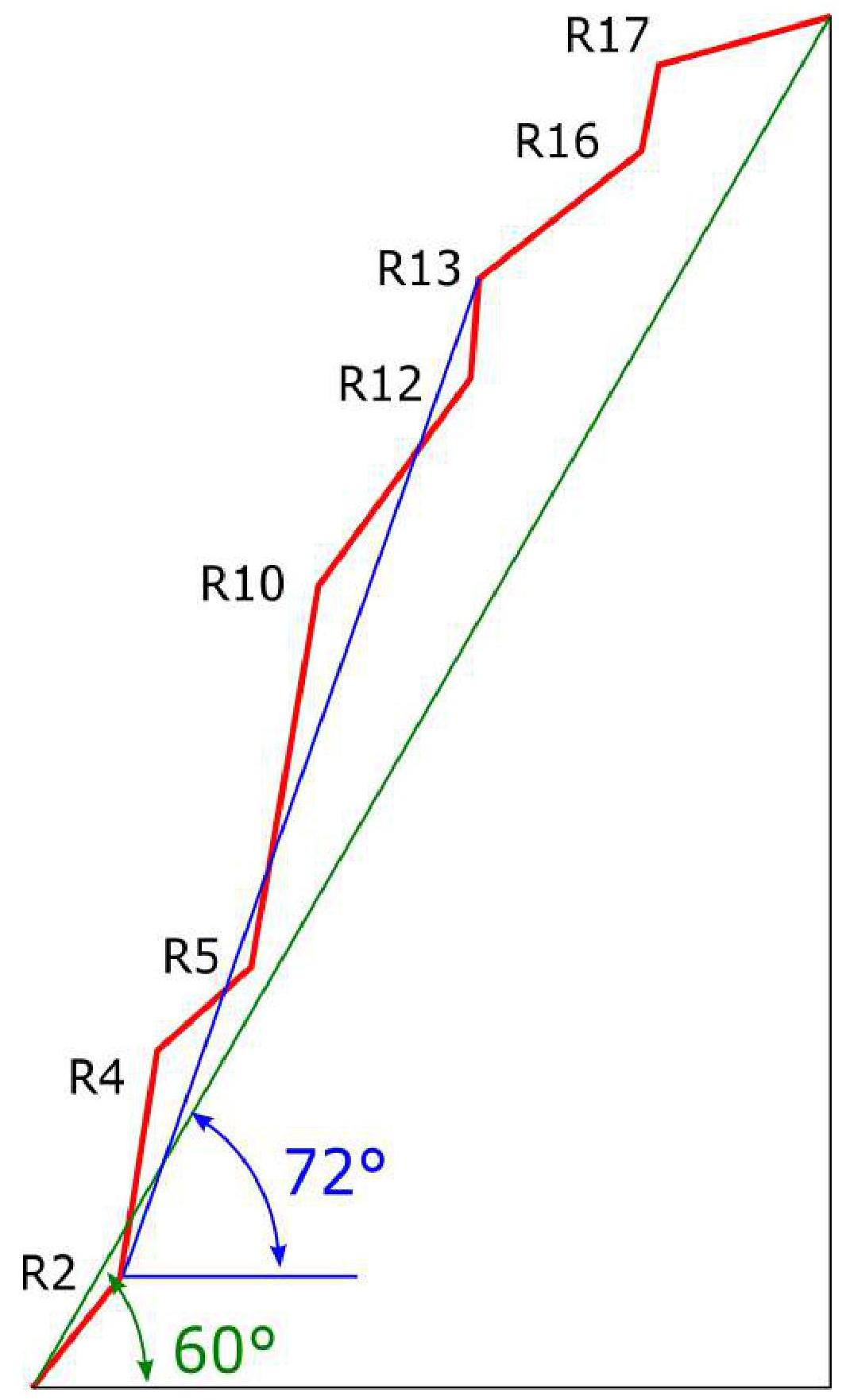
| 3.5 | Height difference of the route (altimeter or GPS data) | 531 m (2683 m above sea level – 3214 m above sea level) |
| 3.6 | Route length (in meters) | wall part – 775 m, ridge – 200 m, total – 975 m |
| 3.7 | Technical elements of the route (total length of sections of varying complexity with indication of terrain type (ice-snow, rocky)) | 2 cat. rocky – 85 m, 3 cat. rocky – 285 m, 4 cat. rocky – 20 m, 5 cat. rocky – 200 m, 6 cat. rocky – 40 m, 6 A1 – 30 m, 6 A2/A2+ – 115 m, total 6 (climbing + ATO) – 185 m |
| 3.8 | Average slope of the route, ° | 60 |
| 3.9 | Average slope of the main part of the route, ° | 72 |
| 3.10 | Descent from the peak | On foot, southeast, traversing the slopes of Hacettepe peak into Cimbar vadisi valley |
| 3.11 | Additional route characteristics | No water on the wall part of the route. Snow on the plateau. |
| 4. Timing of route passage and overnight stays | ||
| 4.1 | Time of movement (team's man-hours, in hours and days) | 14 hours (1 day) |
| 4.2 | Overnight stays | one, bivouac (on the summit) |
| 4.3 | Time of route preparation | - |
| 4.4 | Departure on the route | 7:00 May 9, 2023 |
| 4.5 | Arrival at the summit | 21:00 May 9, 2023 |
| 4.6 | Return to base camp | 12:00 May 10, 2023 |
| 5. Characteristics of weather conditions | ||
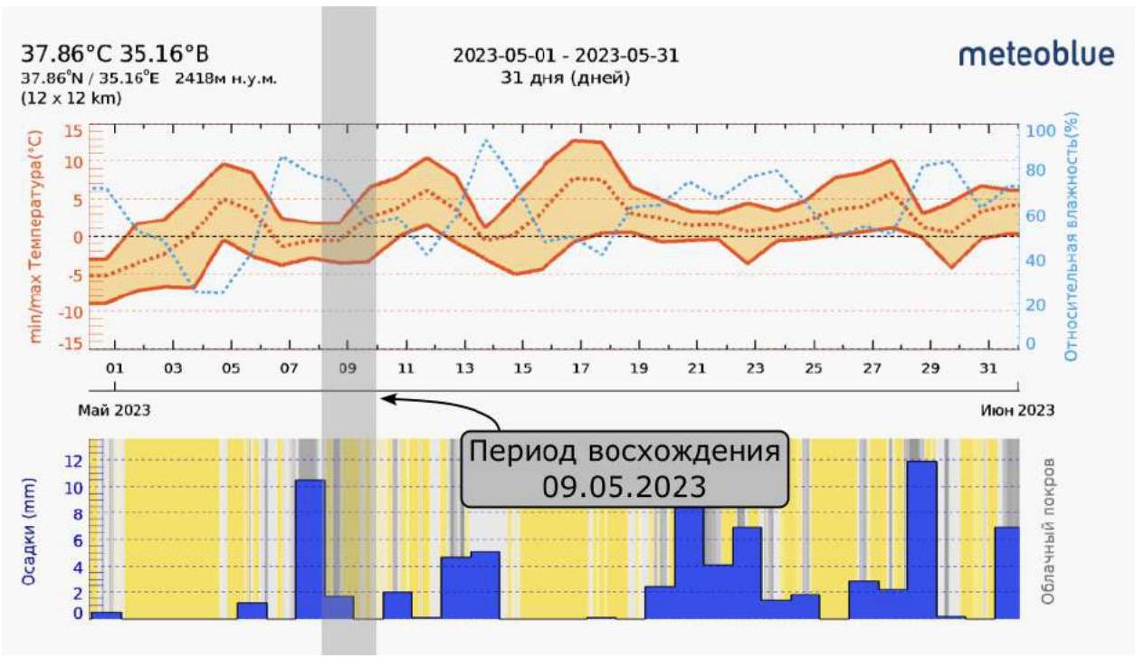
| 5.1 | Temperature, °C | −5°C – +15°C |
| 5.2 | Wind speed, m/s | Gusts up to 15 m/s |
| 5.3 | Precipitation | Clear in the first half of the day, light snow in the second half, strong gusty wind up to 15 m/s |
| 5.4 | Visibility, m | 100–10,000 m |
| 6. Responsible for the report | ||
| 6.1 | Full name, e-mail | Andrei Olegovich Panov aopanov@gmail.com |
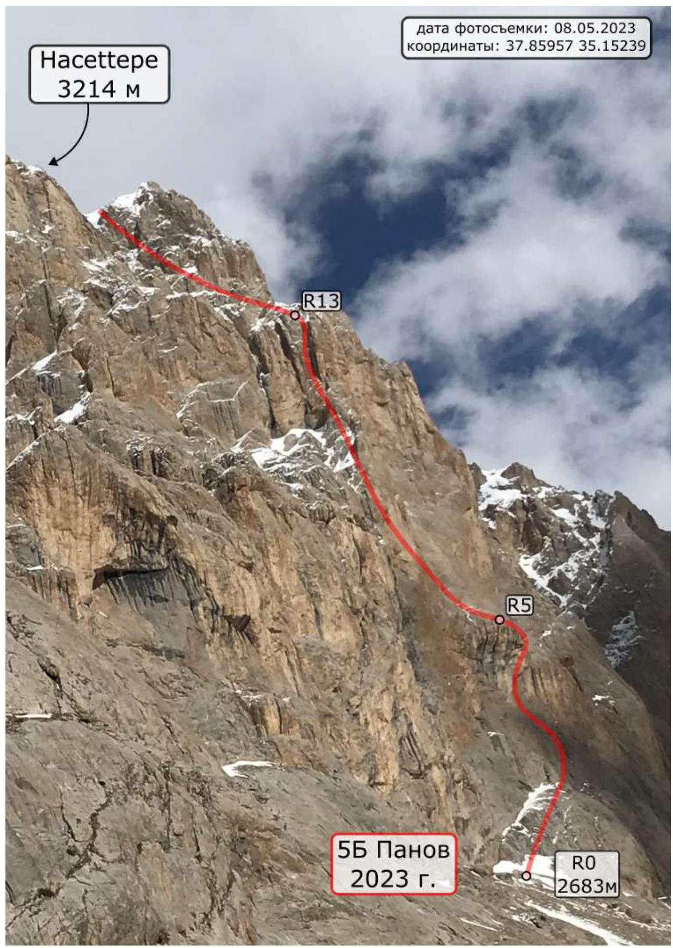
General photo / route profile
Drawn route profile
Area map

Area photopanorama
Ascent Description
Currently, there is only one mountaineering route in Turkey's database in the FAR – to the peak of Ercijyes 3917 m:
- 12.12.7 Ercijyes 3917 m (Turkey), via NE ridge, 2A, M.A. Donskov 2018.
Our route is located in a different region of Turkey – the Aladaglar mountain range.
"Alps of Turkey", as Aladaglar is often called, is the main part of the Taurus Mountains and is situated between the cities of Nigde, Kayseri, and Adana. With about 20 peaks over 3500 m and seven valleys.
Aladaglar has around 20 peaks above 3500 m and offers about 400 routes of various categories, making it the most explored mountain range in Turkey. The rocks are mainly dolomitic limestone, sometimes of poor quality. Overall, this area is suitable for "technical" mountaineering. The highest peaks of Aladaglar are:
- Kızılkaya (Kızılkaya) – 3771 m
- Demirkazik (Demirkazık) – 3757 m
- Kaldı (Kaldı) – 3734 m
- Kızılyar (Kızılyar) – 3654 m
- and the peak with the beautiful name Vayvay (Vayvay) at 3600 m.
Drilling with pitons in Aladaglar is strictly prohibited.
One can reach Aladaglar by various means. The easiest way is by plane to the nearest cities: Kayseri or Adana. If traveling through Antalya, Istanbul, Ankara, or Trabzon, one can use the bus service, which is well-developed in Turkey.
For example, the journey from Antalya passes through the large industrial city of Adana. An express bus to Adana can take around 10 hours. However, it's more convenient to travel to the city closest to the national park – Nigde. The most convenient way is by:
- a rented car.
In early May, the season just begins. There is still snow on the slopes, and the air temperature is quite cold. There are no huts or shelters in the mountains; one can only stay in tents. Accommodation options include:
- Aladaglar Camping Bungalow www.aladaglarcamping.com↗ (37.82522, 35.05046) near the village Cukurbag-Martı Deresi on the western slopes of Aladaglar
- or the Turkish Alp Federation's hut in the town of Demirkazik – Demirkazik Mountain Hut (DMH) https://tdf.gov.tr/dagevi/↗ (37.85807, 35.09699)
To reach the Cimbar vadisi, where Hacettepe peak is located (37.85832, 35.16142), one can hike through the Cimbar canyon, which has two sources. One of them (left branch) starts almost from under Demirkazik. Both sources are passable; there is a trail along the bottom with some minor climbs. Water is only available on a specific section in the right (northern) source of the canyon. The entrance to the canyon from below is directly from the road (37.86195, 35.10229), half a kilometer from DMH. The approach to our base camp (37.86370, 35.14265) will take approximately 2 hours.
Additionally, several dirt roads lead from DMH to the peak plateau of the canyon. The road is passable for a passenger car. There are places to pitch a tent and leave a car (37.85017, 35.12058). Further along the trail, one can reach the Cimbar valley. One needs to move northeast to the confluence of the two canyons and then east through a small pass to descend to the base camp.
Our route can be conditionally divided into two bastions:
1st Bastion:
- The route begins with a large ledge going to the right, from where steep climbing starts along internal corners on unreliable terrain.
- The first key of the route (R3–R4) is a sickle-shaped cornice. It's visible from the ground due to large black stains – this is a landmark for the route.
- The cornice is passed using ATO; one needs to be prepared for a couple of transitions on relief sky hooks.
- At the end, the terrain flattens out, leading to a large ledge where a bivouac for one small tent is possible – R5.
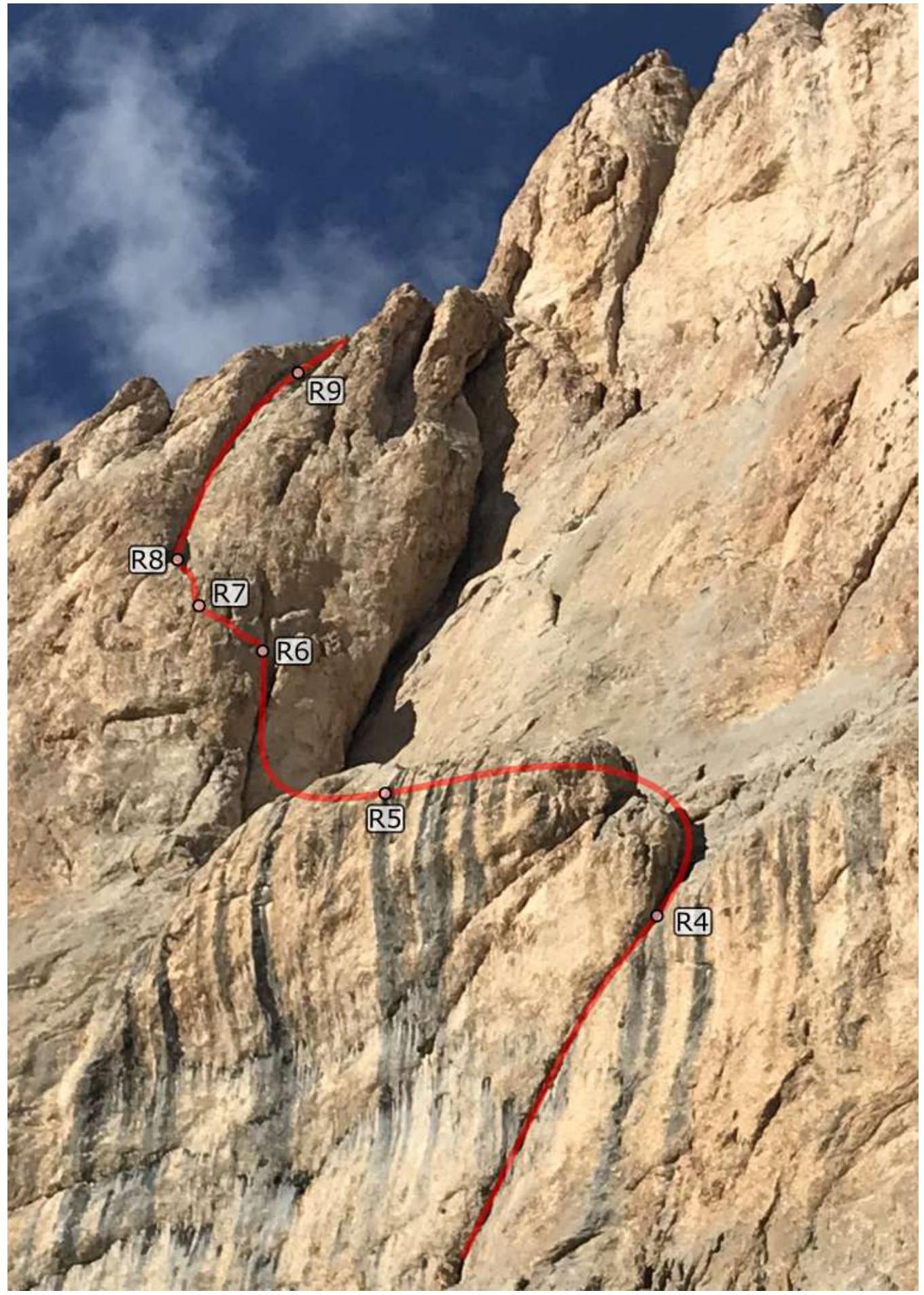
- Next is a large internal corner – the second key of the route (R5–R8). The terrain is heavily destroyed, cracks are filled with moss.
- Follow upwards along a narrow crack until it narrows, make a pendulum to the left (R6–R7) – into another narrow crack.
- Continue movement upwards until it narrows, make a second pendulum to the left, into the base of a large internal corner (R8–R9).
- Move up the corner until it flattens out.
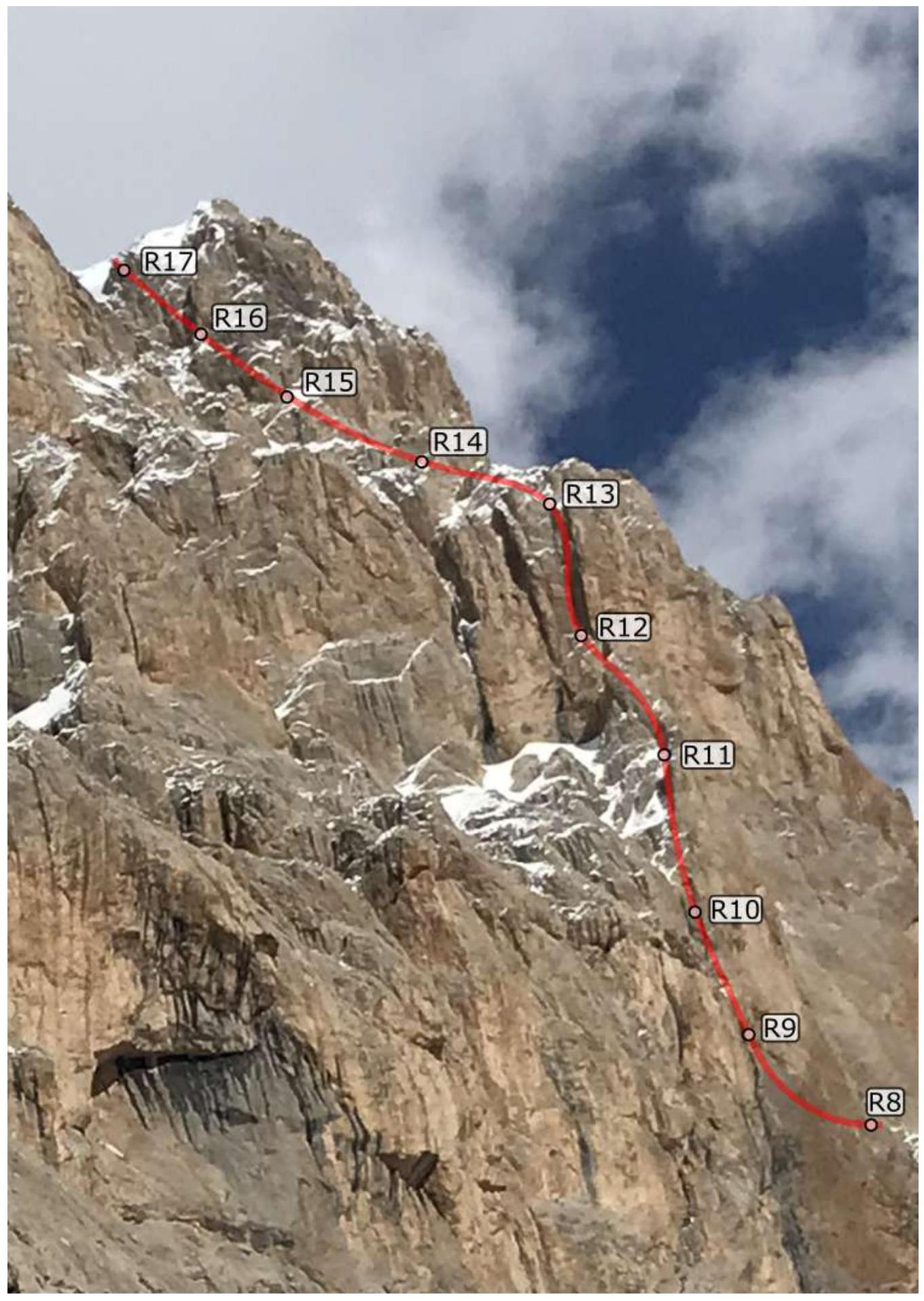
2nd Bastion:
- Pass through simple rocky "feathers", occasionally descending and traversing.
- Approach a small overhanging wall, climb it to reach slabs under a large internal corner with a black stain (R12–R13).
- Move up the corner – this is the third key of the route. In May, the crack is filled with ice; move very carefully, as the terrain in the upper part is heavily destroyed.
- Traverse left along ledges and rocky walls, descend by climbing to a snowfield at the base of a couloir.
- Pass a couple of ropes through snow to the base of a frozen waterfall.
- In May, there's a lot of snow. Sometimes one has to wade through waist-deep snow.
- Move to the left wall, which is covered in ice.
- Overcome the overhang and reach the summit plateau. Move upwards, avoiding rocky outcrops until the summit.
Technical photos of the route
Lower part
Middle part
Upper part
Approach
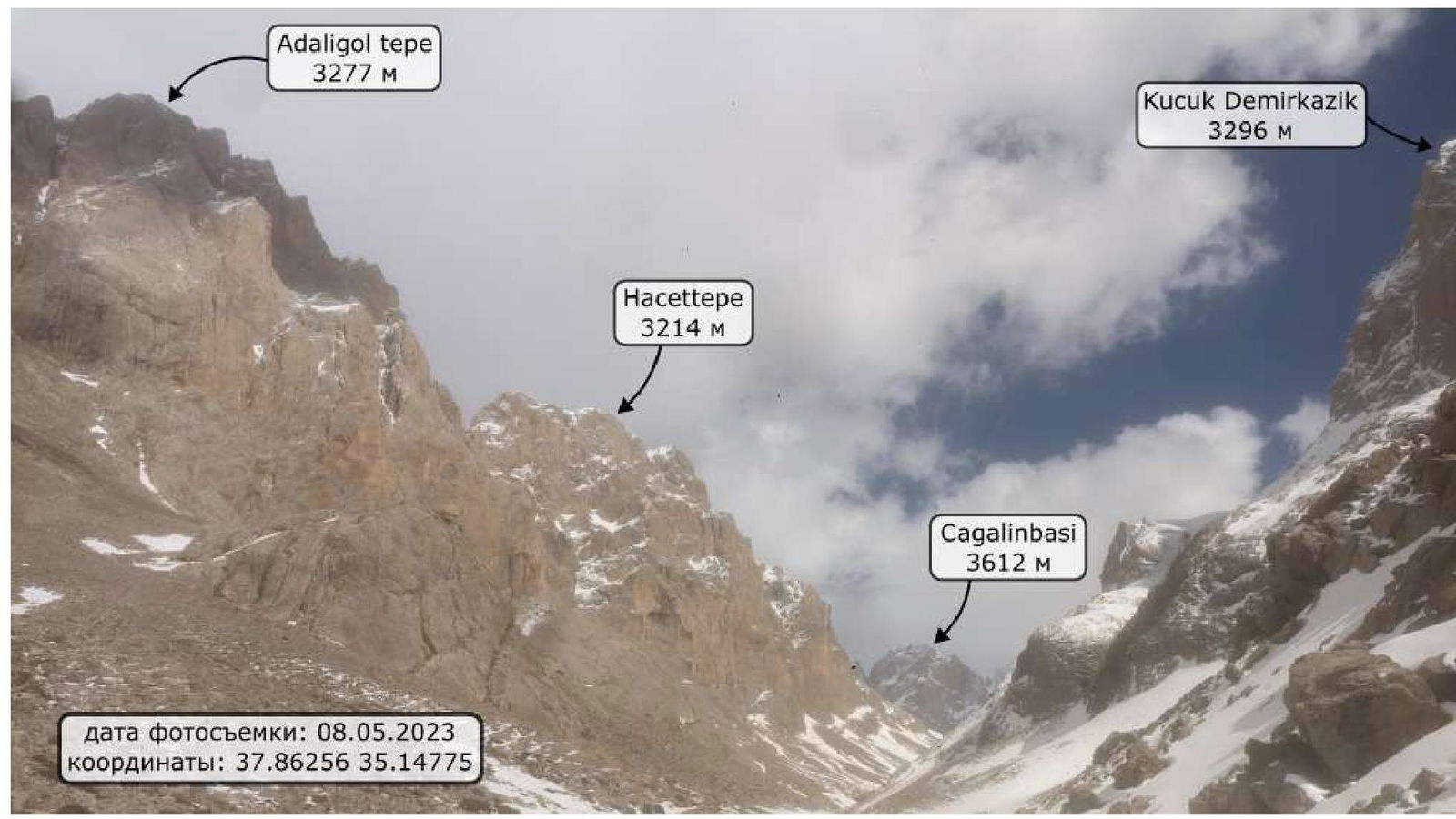
From base camp (37.86374, 35.14269) on the moraine, move along the trail alongside the riverbed (1.5 km). In May, the trail may be hidden under snow; the riverbed and nearby peaks serve as landmarks. To the left is the peak Maly Demirkazik (3296 m), to the right are the peaks Emmi Tepi (3196 m) and Adaligol Tepi (3277 m).
The start of the route (37.85639, 35.15864) is marked by a sickle-shaped cornice with black stains. Directly under it are "ram's foreheads"; one needs to move to the right along them to reach a large ledge.
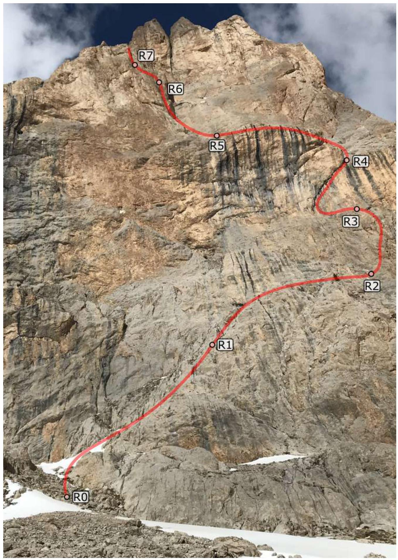
R0–R1 (50 m 3): Approach the internal corner, climb it via simple rocks to a ledge. R1–R2 (70 m 2): Move along the ledge to the right, towards two internal corners. R2–R3 (50 m: 5, V+, 5 m 2): First, climb the left, then the right internal corner – the rock is destroyed, with loose stones. Reach a ledge at the base of the cornice. R3–R4 (55 m: 10 m 2, 15 m 6a+, 25 m A2+, 5 m V+): The first key of the route. Climb a destroyed internal corner, then move along the large sickle-shaped cornice using ATO upwards and to the right, with several transitions on relief sky hooks, and the last five meters via an internal corner to a flattening. R4–R5 (70 m 3): Move along the ledge to a huge internal corner. R5–R6 (50 m: 5 m 3, 20 m 6a, 25 m A2+): Climb the internal corner, then use ATO through small cornices (second key), reaching the point where it splits into two internal corners. The terrain is destroyed, cracks are filled with moss, and some moves require "blind" ATO. R6–R7 (25 m: 5 m 6a, 10 m A2, 10 m 5c): Move along the left crack, veering left. After 10 m, the crack becomes too narrow and disappears; make a pendulum to the neighboring crack on the left. R7–R8 (25 m: 10 m 5c, 5 m A2, 10 m V): Continue moving upwards and to the left, make another pendulum to the left, and reach the base of a large internal corner. R8–R9 (40 m: 30 m V+, 10 m A1+): Climb the internal corner-chimney upwards; in the upper part, move to the left wall and then reach the base of the ridge (in the middle of the wall). R9–R10 (40 m V): Climb the ridge until it flattens out – the second bastion is visible. R10–R11 (60 m 3): The ridge becomes easier; move towards the second bastion. R11–R12 (40 m: 20 4, 10 m A2, 10 m V): Climb simple rocky "feathers", occasionally descending and traversing, approach a small overhanging wall, climb it to reach slabs, and approach a large internal corner. R12–R13 (40 m 6a/A2): The third key of the route; climb the internal corner, partly using ATO. The corner is filled with ice and destroyed. Reach the base of a snowy couloir. R13–R15 (100 m 3): Traverse left along a rocky wall, descend by climbing into the couloir, move upwards through snow, overcoming small "ram's foreheads". R15–R16 (40 m V): In the upper part, the couloir turns into a frozen waterfall; at its base, move to the left wall of the couloir, climb it. R16–R17 (20 m 6a/A1): The wall is covered in ice; climb it carefully with ATO to reach the summit plateau. R17–R18 (200 m 2): Move across snowy fields, avoiding rocky outcrops, to reach the summit.
Descent
From the summit, move southeast, traversing the slopes of Hacettepe peak and descending towards the valley. Reach gentle slopes-couloirs (37.84949, 35.16832) and descend into the valley. Follow the valley northwest back to the camp.
Route scheme in UIAA symbols
Lower part
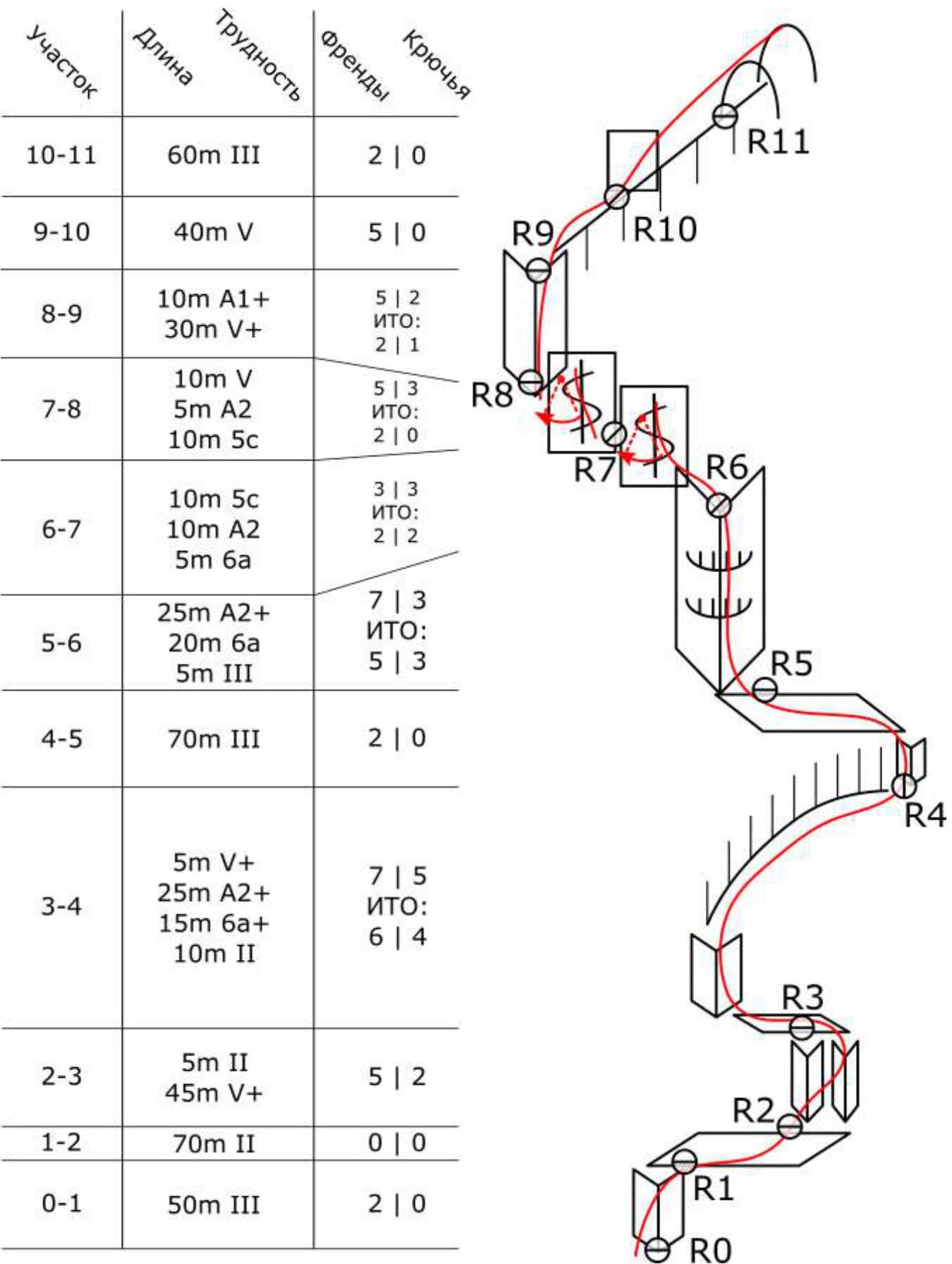
Upper part

Team actions
By the start of the ascent, the season had not yet begun in the area. There was a lot of snow, and the weather was cold for this region. No precipitation was expected for the next couple of days.
May 9, 2023
At 6:00 AM, the team left the base camp with a supply of food and water for two days. By 6:40, they reached the base of the route. The weather was clear and frosty. At 7:00, the leader began working on the route. The first couple of ropes were on "ram's foreheads", followed by challenging climbing on destroyed terrain of the fifth category and passing the first key – a sickle-shaped cornice, using ATO and sky hooks. By 10:00, they reached R5.
Next, they faced challenging climbing on an internal corner, ATO through narrow cracks with two pendulums, and a second large internal corner. The terrain was destroyed, and cracks were filled with moss. They reached R10 by 15:00. The weather deteriorated, with strong winds. They continued through rocky "feathers" towards the second bastion.
Ahead was a corner-chimney, the third key of the route. The wall of the internal corner had a characteristic black stain – a good landmark. The corner was filled with ice and slightly leaking. The leader climbed using ATO. In the upper part of the corner, the terrain was very destroyed. They reached R14 by 17:00. Light snow began to fall.
Further along ledges and "ram's foreheads", they moved towards the left wall, at the bottom of which the start of a snowy couloir was visible. At 17:40, they carefully descended to the snow with protection. They passed several ropes up the couloir. There was a lot of snow, and they had to wade through it. They reached the base of a frozen waterfall. Choosing the left overhanging wall, they climbed using ATO to the summit plateau. At 19:30, they moved across snowy fields, avoiding "ram's foreheads":
- At 21:00, they reached the summit.
- Snow continued to fall.
Since the descent was unknown and it was late at night, they decided to set up a bivouac. They pitched a tent on a rocky outcrop on the summit.
May 10, 2023
At 9:00 AM, the weather was clear. From the summit, the entire valley was visible. They began moving southeast, traversing the slopes of the peak. The snow had frozen overnight, making it easier to move. They reached gentle slopes and moved northwest back to the camp.
Movement scheme
For the ascent, they used 2 dynamic and 2 static single ropes, 60 m each. The technique used was alternate. The second participant moved along the fixed static rope with a backpack and top-rope protection. The third participant moved with a backpack along the fixed static rope, protecting himself with a Gri-Gri on a fixed dynamic rope.
Weather conditions
Route safety assessment. Recommendations for subsequent climbers.
We consider the route we passed to be logical, relatively safe, and interesting. No rockfall was observed during the observation and passage of the route. The left part of the wall shows signs of a powerful water and stone flow. Under the sun, snow melts. Climbers should consider this when approaching the rock in May. The approach is not complicated. There is no water on the wall. By its nature and complexity, the route is category 5B according to the Russian classification.
In sunny weather, a significant part of the route can be climbed with free climbing in crampons. The terrain for protection is not always good. The rock is limestone, often destroyed and unreliable. There are several fairly long sections of ATO. Key sections of the route: R3–R4, R5–R9, R11–R13. Section R6–R8 involves passing a narrow crack with ATO A2+, followed by a pendulum to a neighboring crack with poor protection. Also, section R5–R6 includes complex ATO A2 on not very reliable terrain.
Good bivouacs are possible on the R5 ledge and on the summit plateau (the team's bivouac). Semi-reclined bivouacs are possible on ledges along the route.
Recommendations for equipment: a set of "hardware", anchor pitons, rock fiffs, and climbing shoes. Two steps were made on relief sky hooks, but one can manage with fiffs and anchors. No piton equipment was used. With good route conditions and favorable weather, crampons are not necessary. Ropes were not used on the descent.
For weather updates and emergency communication, a Garmin InReach GPS messenger was used.
Photo report
Approach to base camp
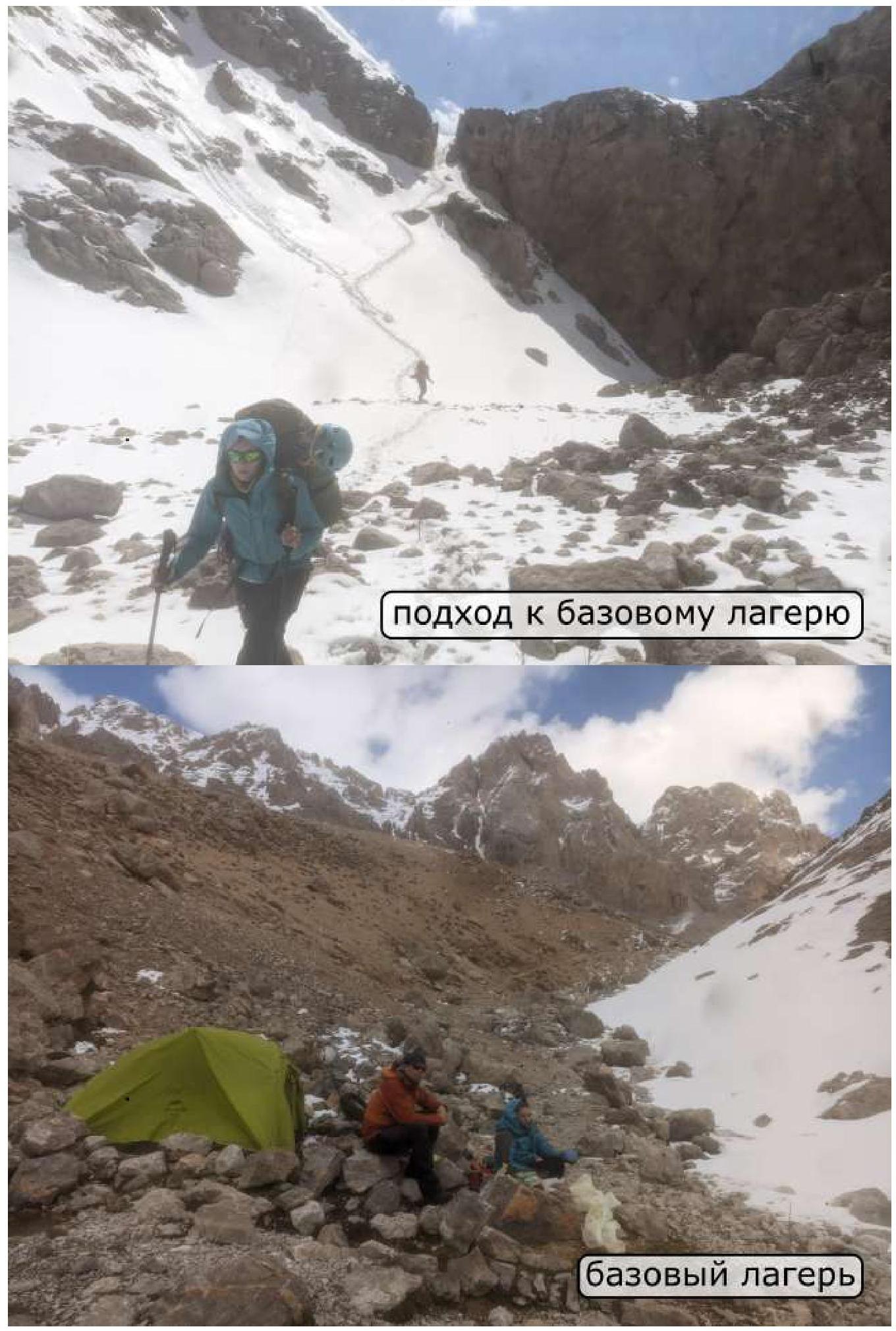
Base camp
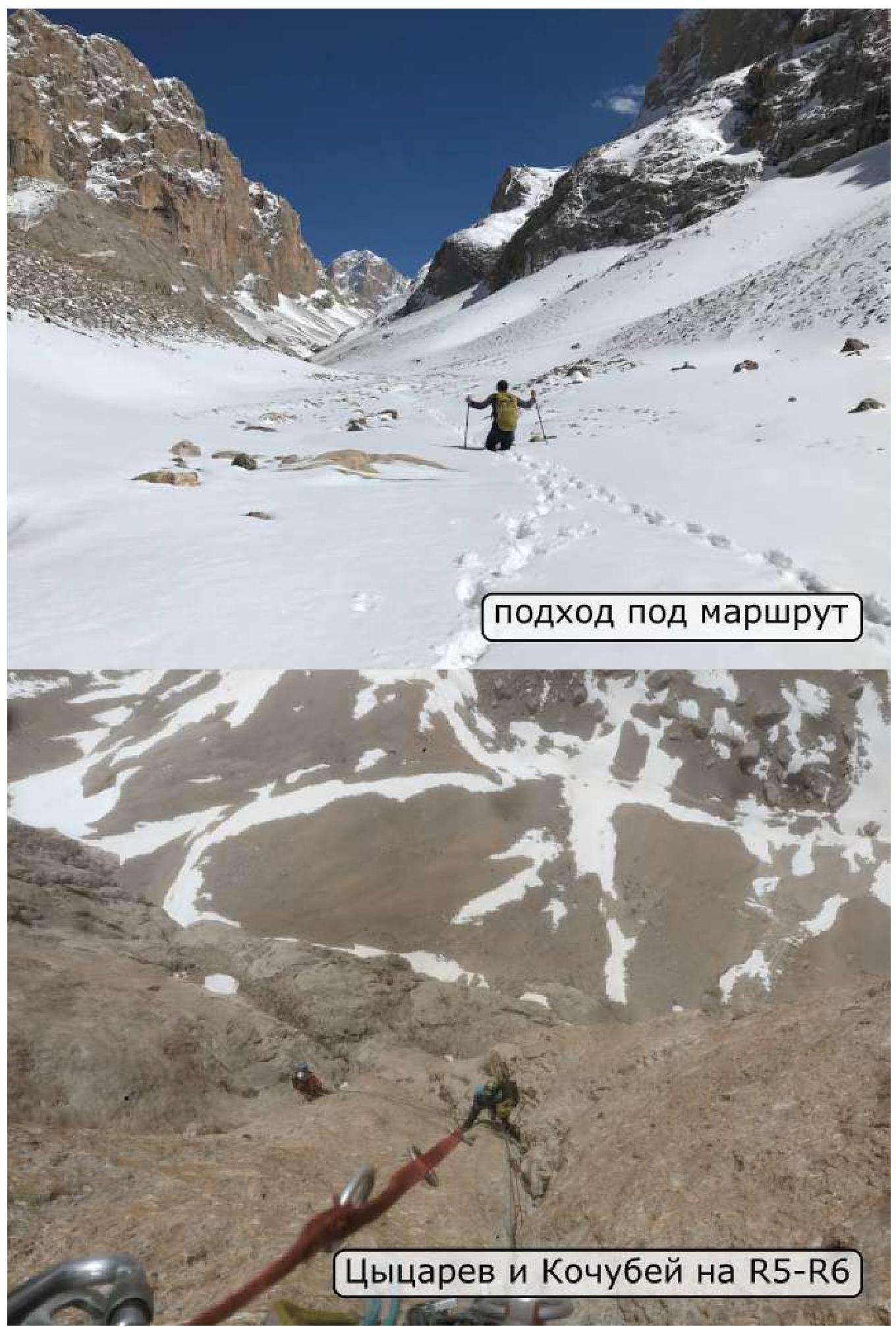
Approach to the route
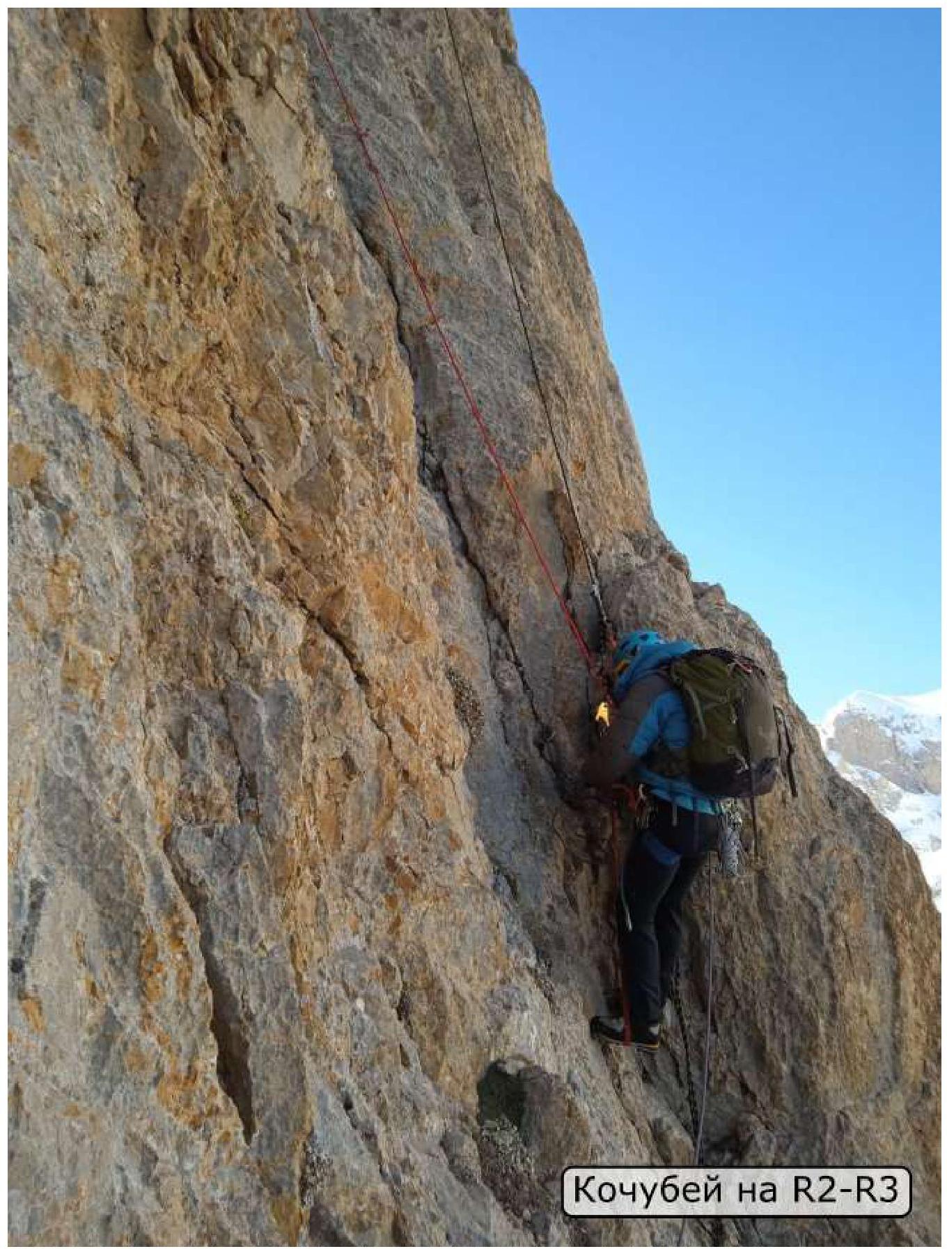
Kochubey on R2–R3
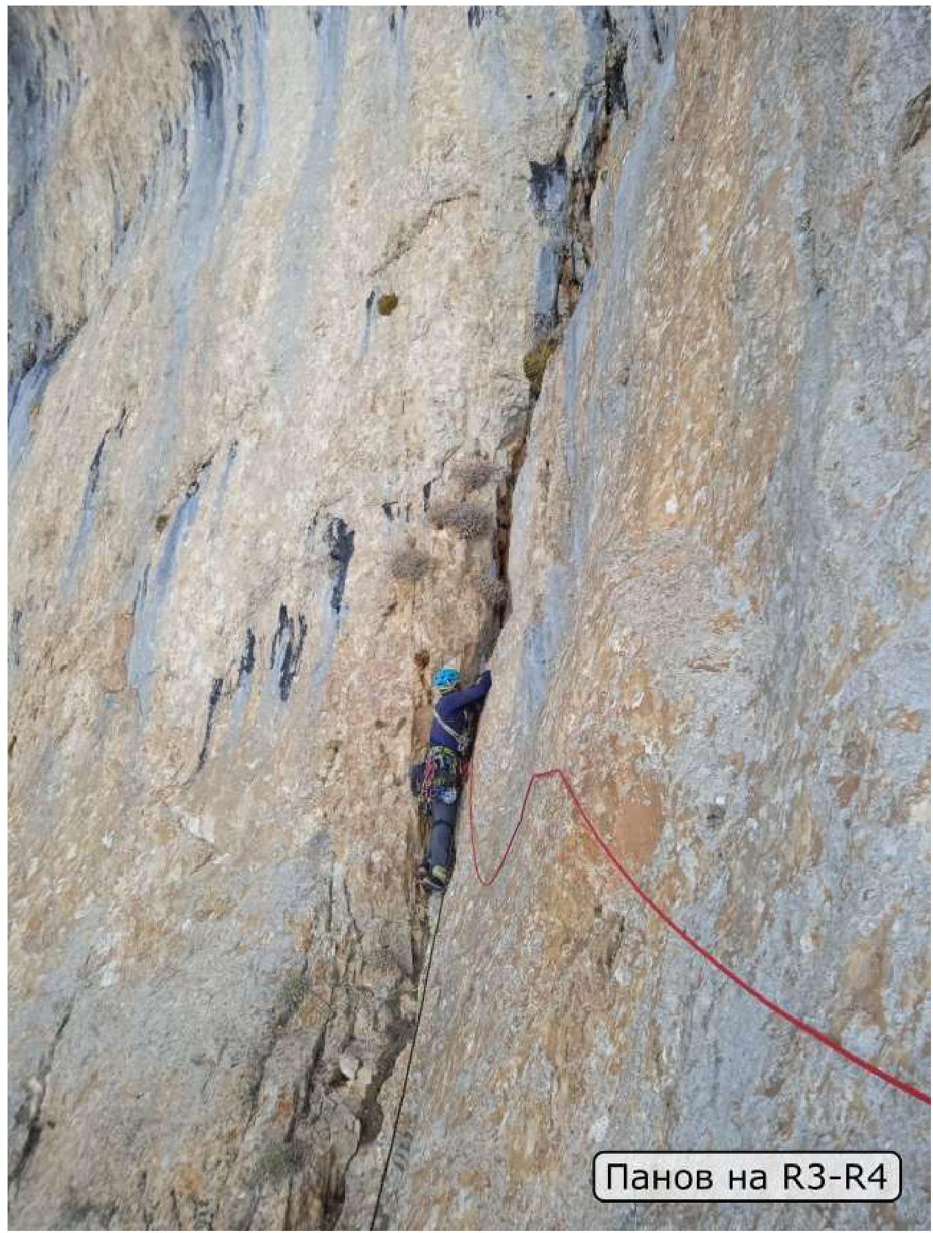
Panov on R3–R4
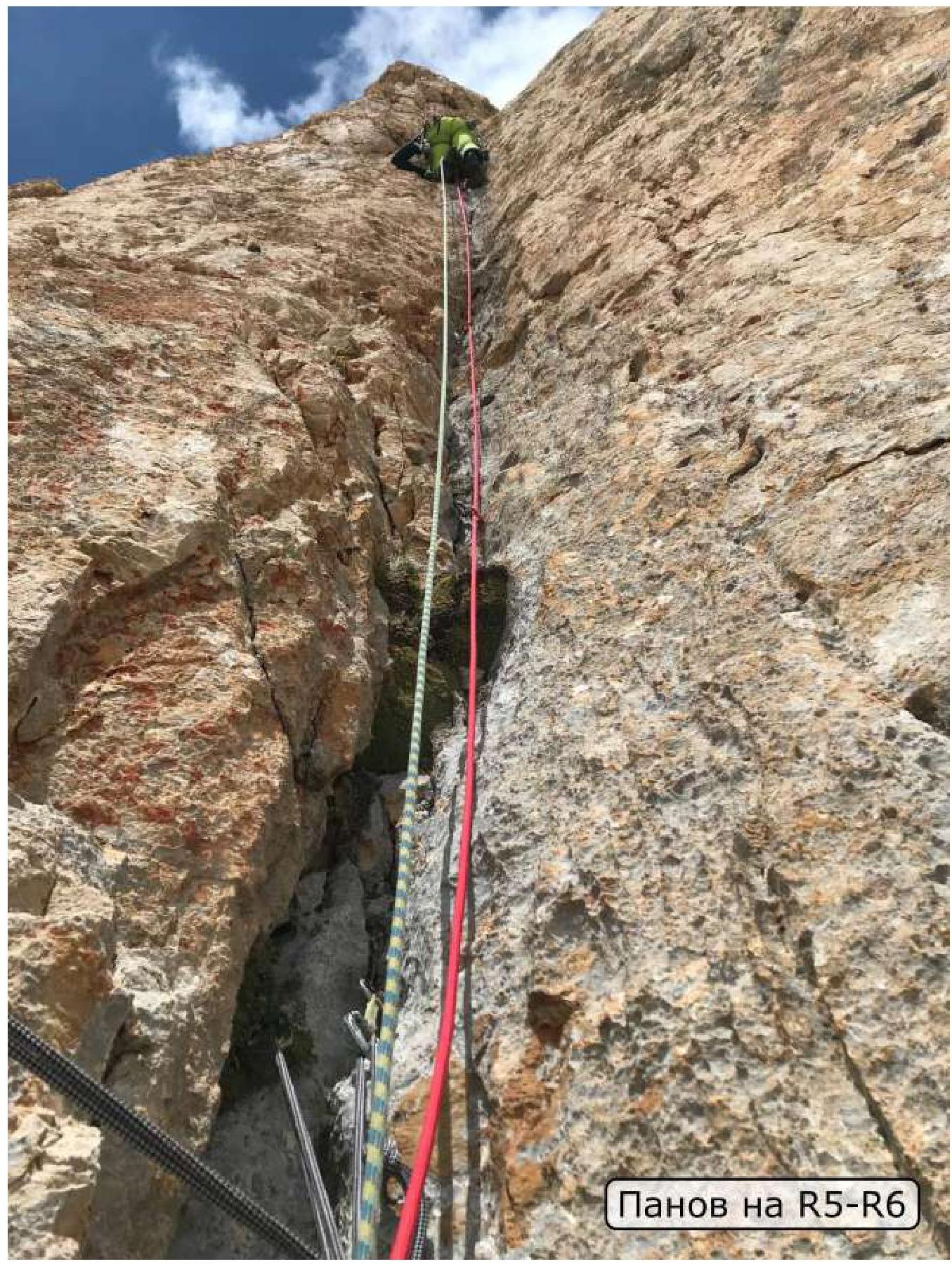
Panov on R5–R6
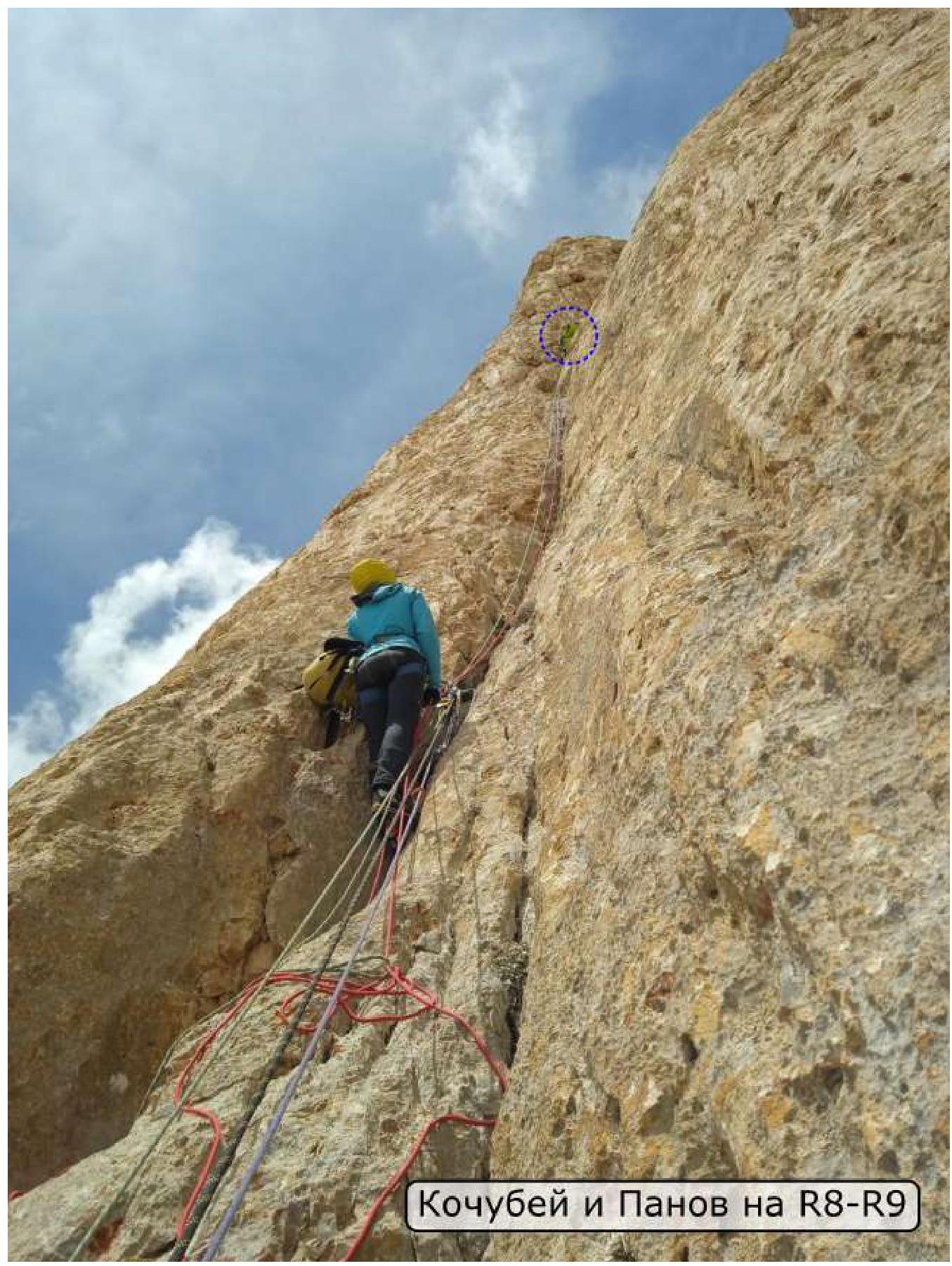
Kochubey and Panov on R8–R9
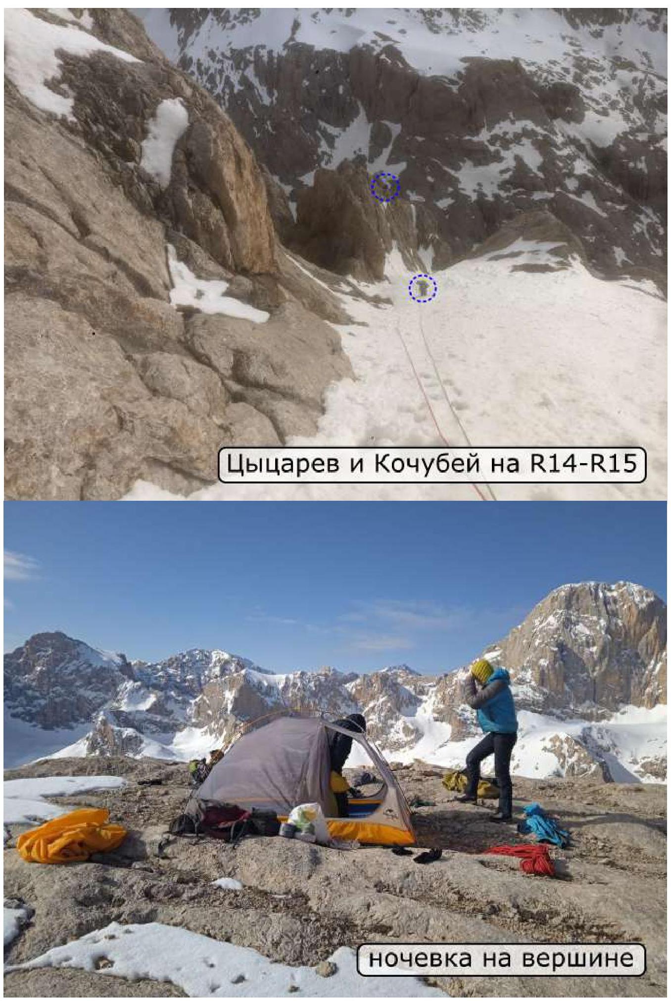
Bivouac on the summit
Tsytsarev A., Panov A., Kochubey O.
Team photo on the summit