
Report on the Ascent of Mount Erciyes via the Northeast Ridge, Approximately Category 2A Complexity Multipurpose Climbing Club “Freeline” April 18, 2018
Ascent Passport
| № | 1. General Information | |
|---|---|---|
| 1.1 | Full Name of Leader, Sports Rank | Donskov Andrey Mikhailovich, 1st sports rank |
| 1.2 | Full Names and Sports Ranks of Participants | Popov Mikhail Lvovich, Candidate Master of Sports; Semenova Olesya Artemovna, 1st sports rank; Orlovskaya Elena Viktorovna, 3rd sports rank |
| 1.3 | Full Name of Coach | Motienko Nikolai Ilyich |
| 1.4 | Organization | MAC “FREELINE” Yessentuki |
| 2. Characteristics of the Ascent Object | ||
| 2.1 | Region | Turkey, Central Anatolia |
| 2.2 | Valley | - |
| 2.3 | Number according to the 2013 Classification Table | - |
| 2.4 | Name and Height of the Summit | Erciyes 3917 m |
| 2.5 | Geographical Coordinates | 38°31′53″ N, 35°26′49″ E |
| 3. Characteristics of the Route | ||
| 3.1 | Name of the Route | Northeast Ridge |
| 3.2 | Proposed Category of Complexity | 2A |
| 3.3 | Degree of Route Exploration | First Ascent |
| 3.4 | Nature of the Route Terrain | Combined |
| 3.5 | Height Difference of the Route according to GPS | 817 m |
| 3.6 | Length of the Route | 1780 m |
| 3.7 | Technical Elements of the Route | Category I rocks/snow – 480 m; Category II rocks/snow – 1300 m |
| 3.8 | Descent from the Summit | Along the Southeast Ridge and East Slope |
| 3.9 | Additional Characteristics of the Route | Water available year-round in the form of snow |
| 4. Characteristics of Team Actions | ||
| 4.1 | Time of Movement | 10:00 (hours:minutes) |
| 4.2 | Overnight Stays | - |
| 4.3 | Start of the Route | 05:00 April 18, 2018 |
| 4.4 | Reaching the Summit | 11:10 April 18, 2018 |
| 4.5 | Return to Base Camp | 15:00 April 18, 2018 |
| 5. Person Responsible for the Report | ||
| 5.1 | Full Name, Phone, E-mail | Donskov A.M. +7(962)0178209 donskov91@mail.ru |
Description of the Ascent
Mount Erciyes (Turkish: Erciyes Dağı) is a large stratovolcano located in Turkey, in the Central Anatolia region. The summit height is 3917 m. The city of Kayseri with an international airport is located twenty kilometers from the foot of the mountain. The Erciyes ski resort operates on the eastern slopes of the volcano; most ascents of the volcano start from this location. The lower stations of the lifts are approximately 2100 m, and the maximum height of the upper station is approximately 3100 m.
It is easy to reach the Erciyes ski resort:
- by scheduled buses;
- or by using taxi services.
Most ascents are made along the Southeast Ridge or from the crater of the volcano along the eastern slope. These ascent options were not considered by the team as they do not contain a sufficient set of obstacles for further classification of the route by the Climbing and Hiking Federation of Russia. The ascent along the Northeast Ridge is the shortest and most technically challenging option from the Erciyes ski resort.
The first ascent of the summit was presumably made by British scientist and geologist William John Hamilton in 1842.
General photo of the summit and ascent route
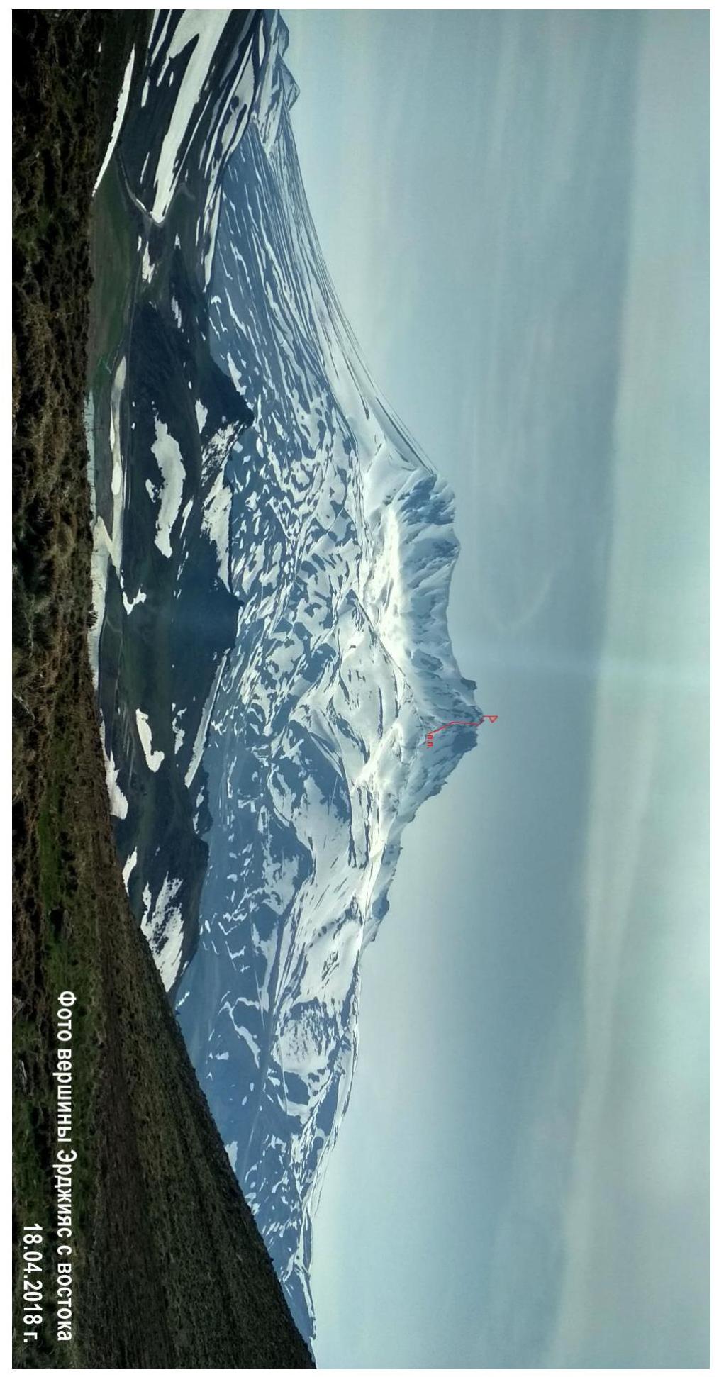
Photo of the route profile on the right

| Section № | Terrain Characteristics | Category of Complexity | Length, m | Pitons |
|---|---|---|---|---|
| R0–R1 | Scree ridge | 1 | 230 m | - |
| R1–R2 | Scree ridge | 1 | 250 m | - |
| R2–R3 | Fine scree, snow, rocks | 2 | 1000 m | - |
| R3–R4 | Snow ridge, rocks | 2 | 300 m | - |
Description of the Ascent
| Section № | Description | Photo Number |
|---|---|---|
| R0–R1 | From the upper cable car station, move upwards along the scree ridge leading to the summit. Bypass the rocky outcrops encountered on the way on either the right or left. Exit to a flattening. | R0–R1 |
| R1–R2 | Further, there is a slight dip in the ridge. Move along the ridge, bypassing the “red gendarme” on the left. Exit under the beginning of the ascent. | R1–R2 |
| R2–R3 | Move up along the ridge to the first protruding rocks. Bypass on the left in a wide snow couloir, which leads out onto the ridge to the sub-summit. Be extremely cautious when moving in the couloir - there are icy sections under the snow. Movement is also possible along the rocks on the right. After exiting onto the ridge, bypass the gendarme on the right, and exit onto the sub-summit. | R2–R3 |
| R3–R4 | Move in the direction of the rocky summit tower along the sharp snow ridge “knife-edge”. On the left, there is an exit to the rocky summit tower via несложным разрушенным скалам. | R3–R4 |
Photo of section R0–R1
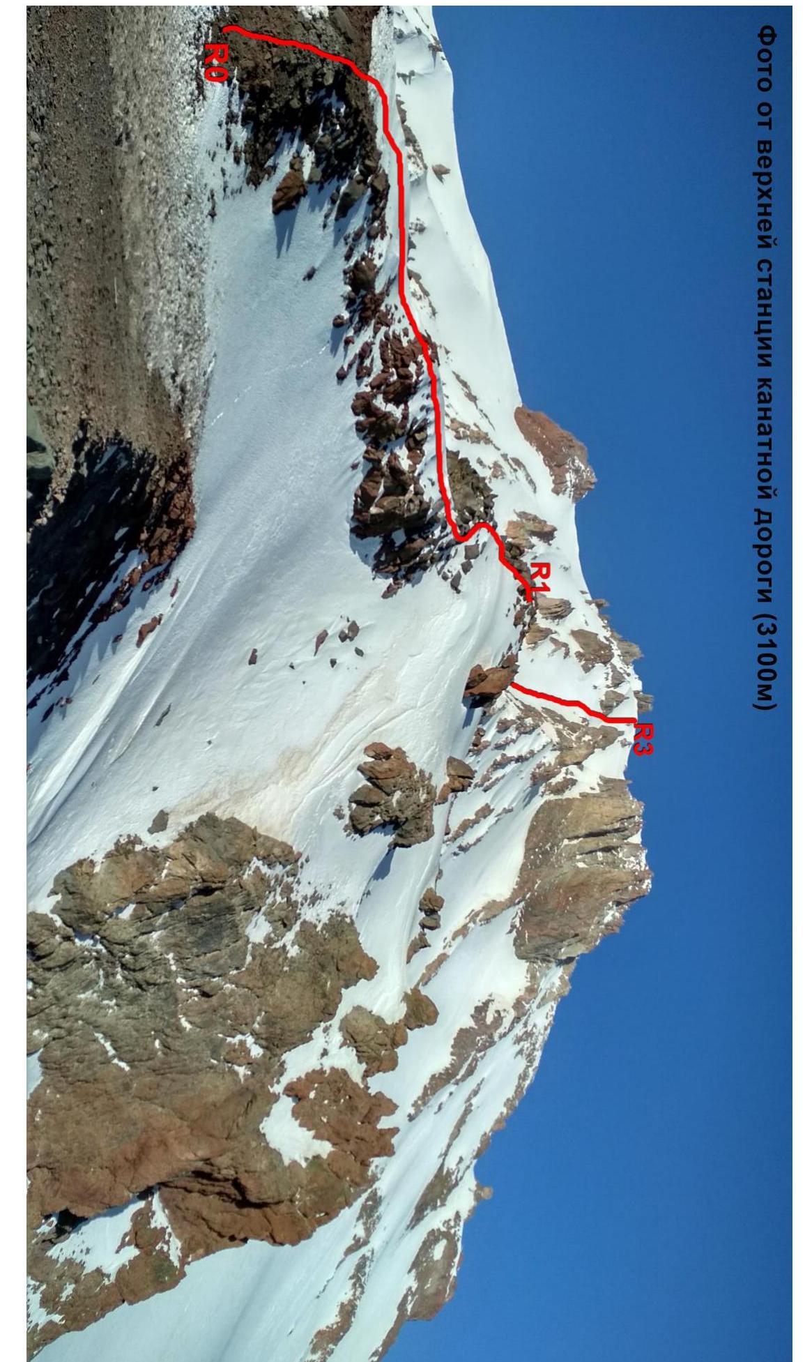
Photo of section R1–R2
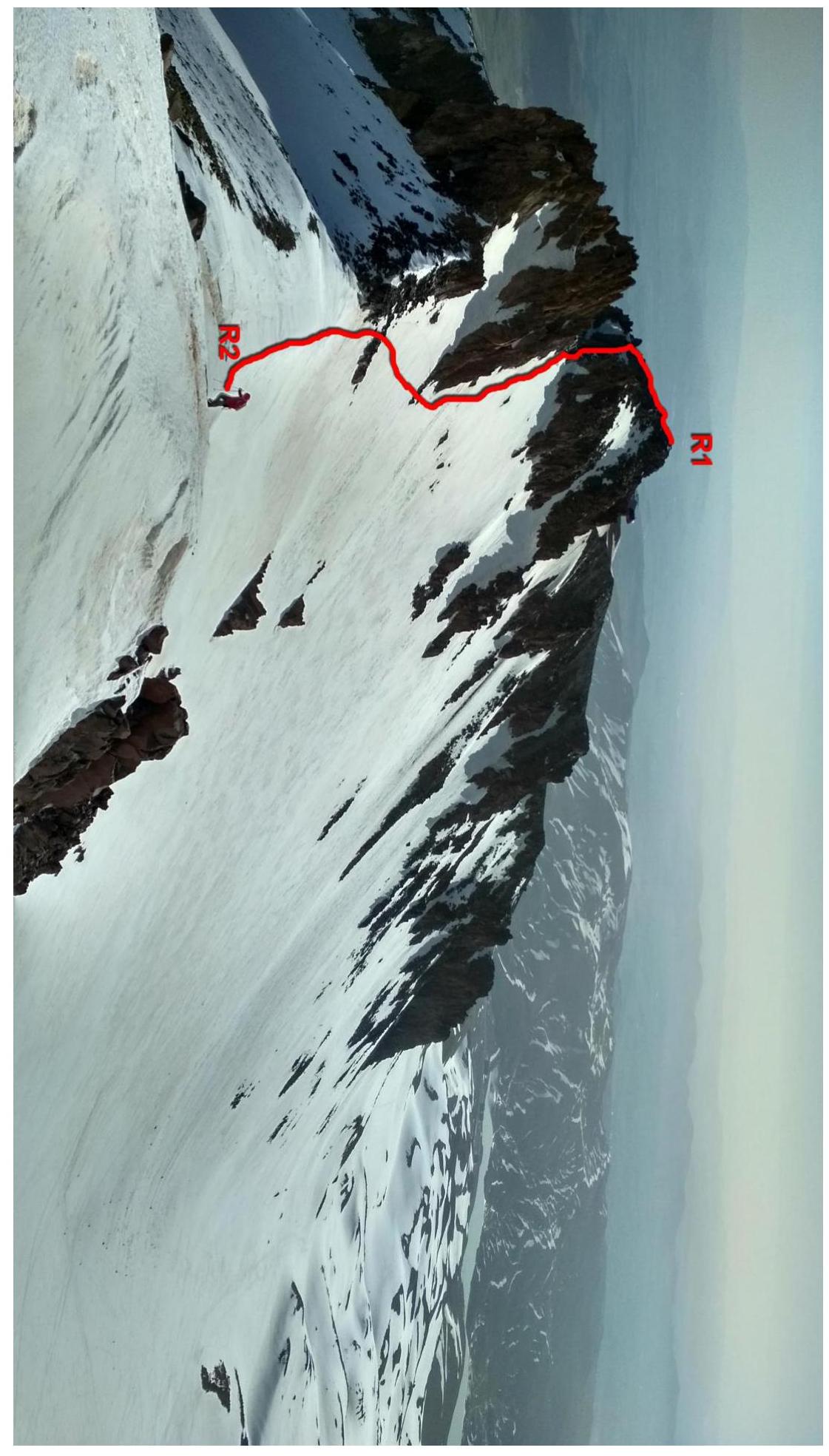
Photo of section R2–R3 (bypass of the red gendarme)
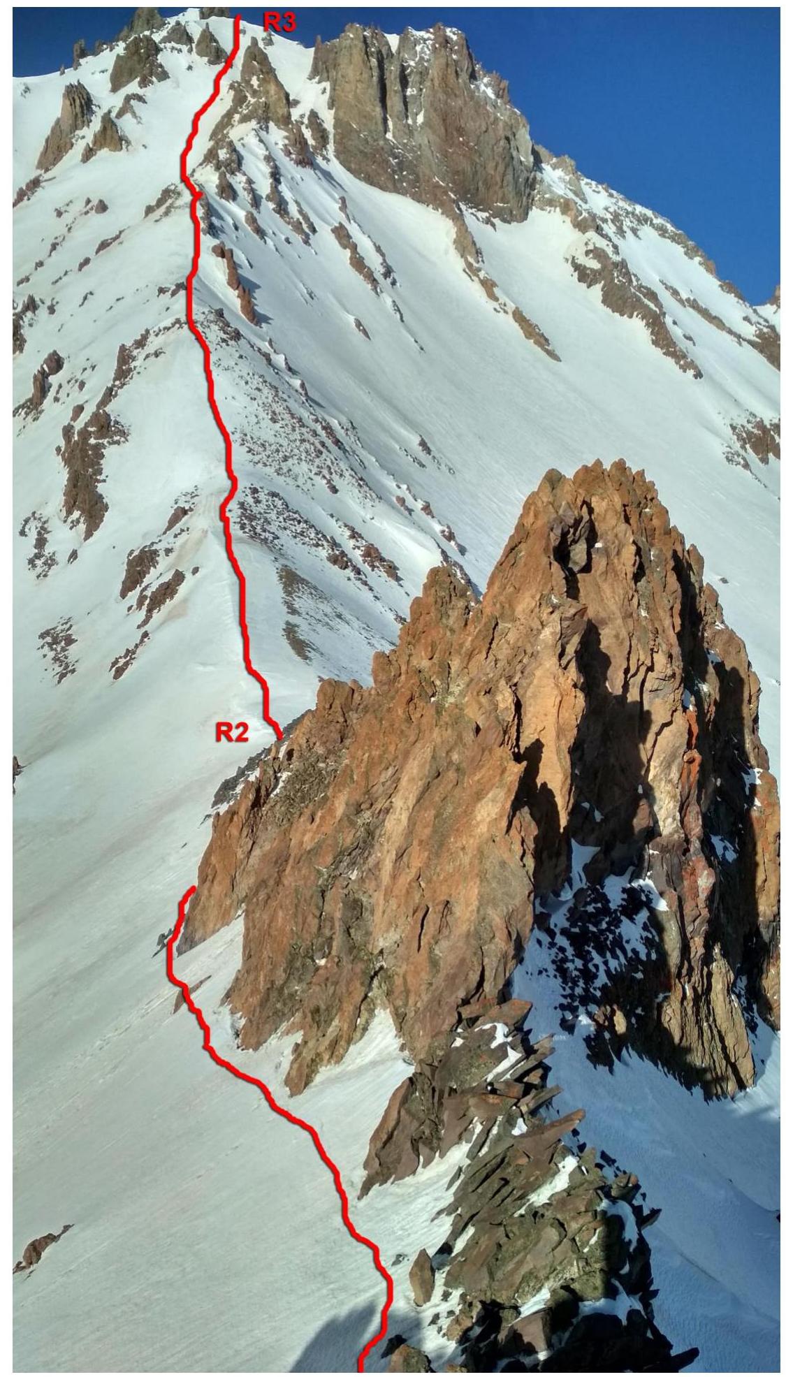
Photo of section R3–R4
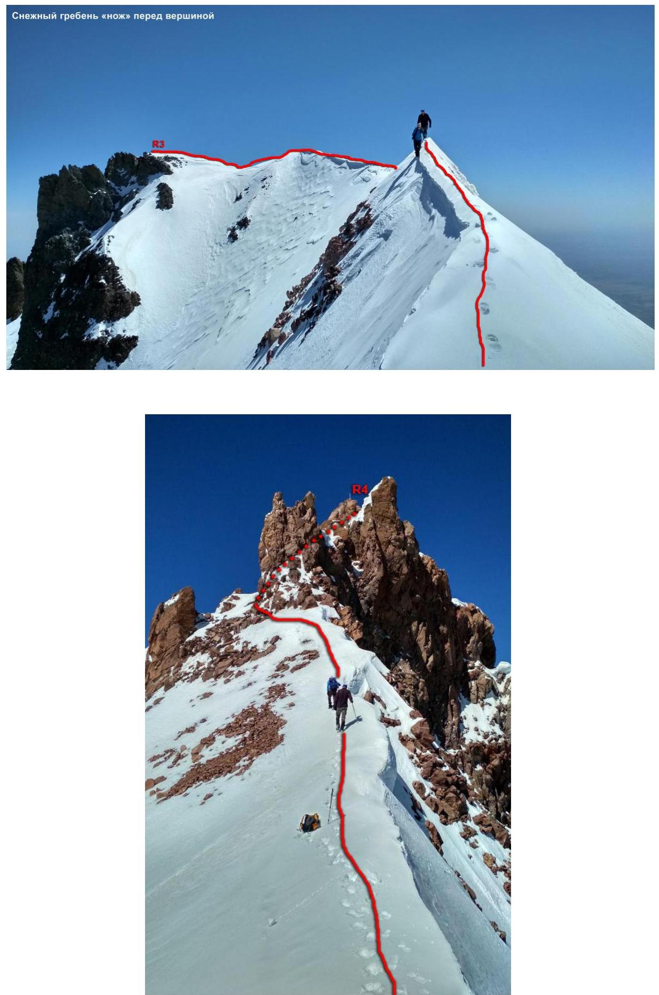
Photo of the summit

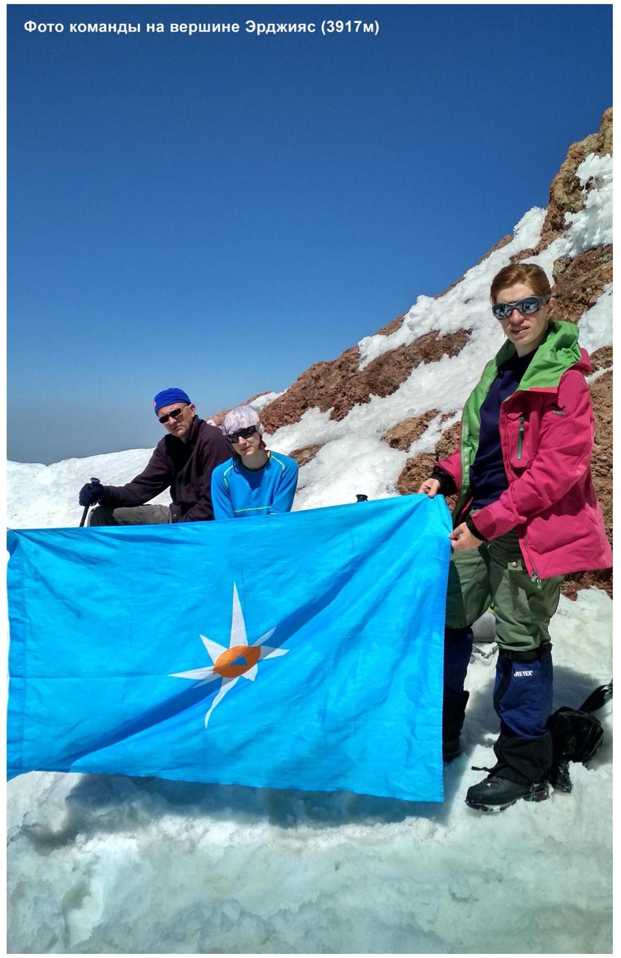
Photo of the team on the summit
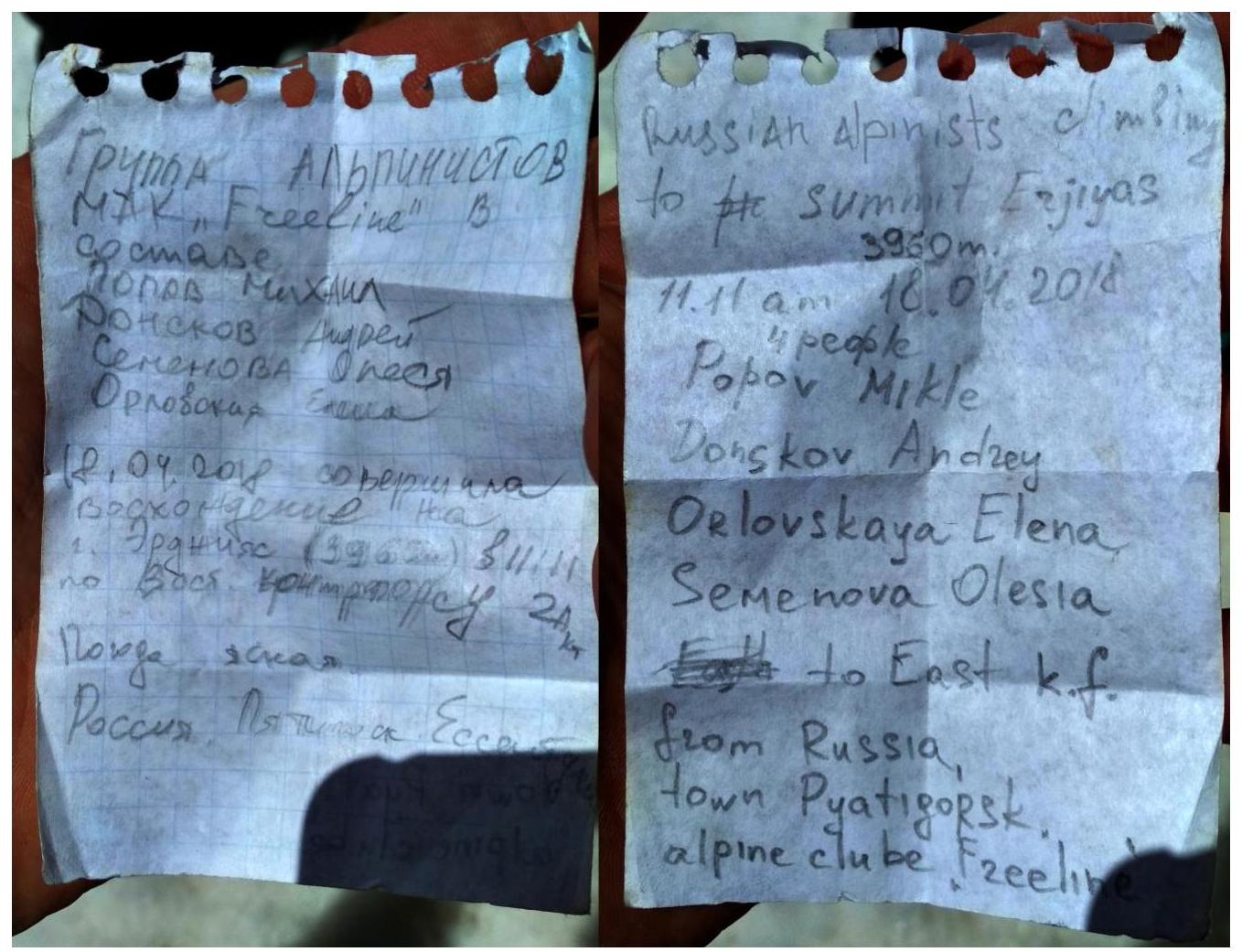
Note left on the summit
Conclusions and Recommendations for the Route
- The route corresponds to the specified half-category of difficulty.
- Technically more challenging than the ascent options on Mount Elbrus via the northern and southern slopes.
- It is safer to descend from the sub-summit along the southeast ridge, then along the eastern slope, descending into the cirque (volcano crater).
- Water is available on the route year-round in the form of snow.
- Mobile communication is stable across the entire summit.
- It is recommended to notify the management of the Erciyes ski resort upon completing the ascent. This can be done at the administrative building, where recommendations for the ascent and summit maps can also be obtained.
- As of 2018, there were no permits or prohibitive documents required for staying on the summit territory.
- Emergency services phone number is 112.