Alpinism School
Rock climbing category
REPORT
First ascent to the summit 3440 m, Peak AKF South, from the east via the northern ridge. Afghanistan, Lalmi Shan Mountains, Muntij mountain range.
Instructor-methodologist category I Bogolyubov V.V.
Ascent Passport
- Ascent category: Rock climbing.
- Ascent area: Afghanistan, Lalmi Shan Mountains, Muntij mountain range.
- Summit, route: First ascent to the summit 3440 m; Peak AKF South, from the east via the northern ridge.
- Estimated category of difficulty: 2A
- Height difference: 1400 m
- Total route length: 5660 m
- Length of key sections: 120 m
- Including 2nd category of difficulty: 40 m
- Including 3rd category of difficulty: 80 m
- Pitons used: rock _____, ice _____, chocks _____, bolt pitons _____
- Duration: 12 hours
- Leader's full name: Bogolyubov V.V., sports rank: Candidate Master of Sports
- Participants' full names: 19 students, sports rank: "Alpinist badge"
- Coach's full name: Bogolyubov V.V., sports rank: Candidate Master of Sports
- Departure to the route: 6:00, date May 30, 2009.
- Reaching the summit: 14:20, date May 30, 2009.
- Return: 16:00, date May 30, 2009.
Peak AKF 3446 m 2A South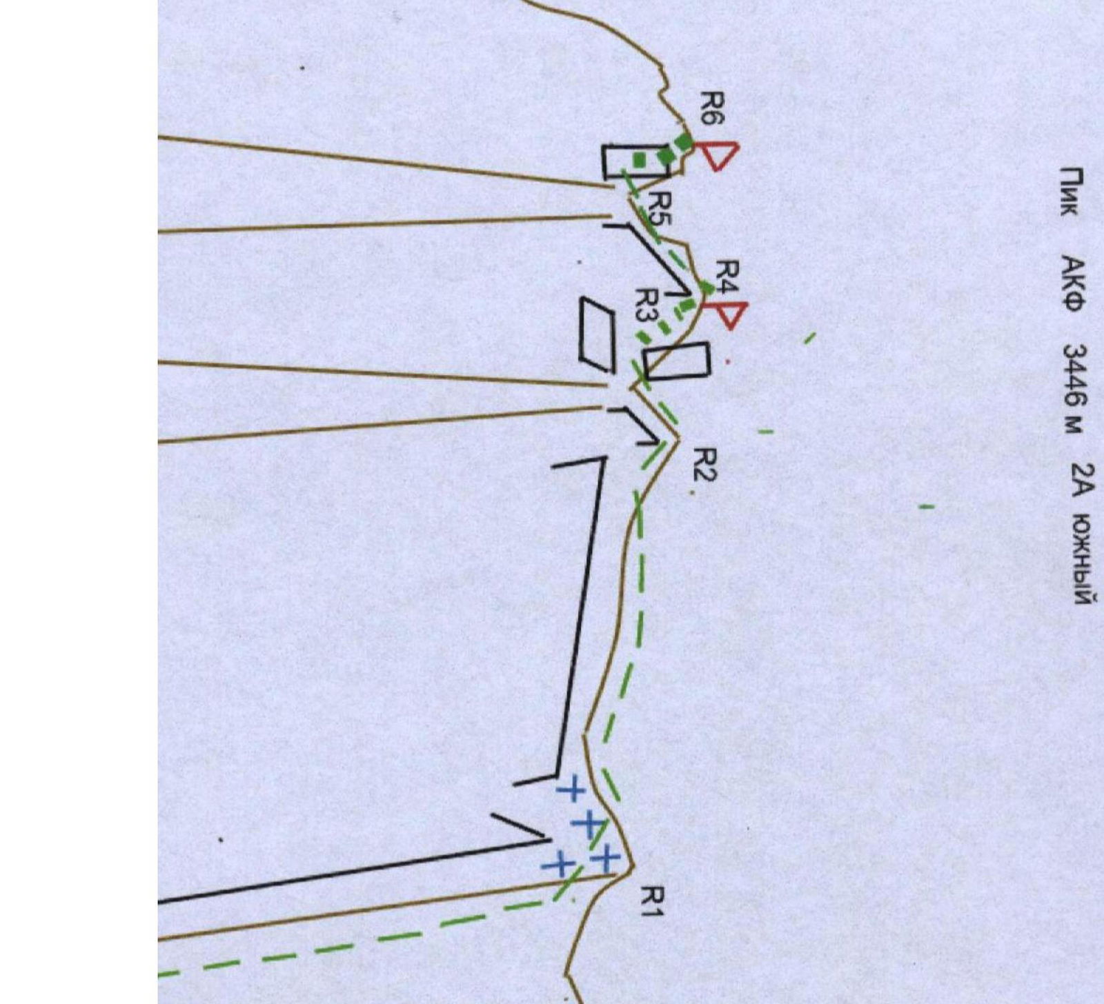
Route Description
| Section # | Cat. of diff. | Steepness | Length | Belaying | Notes |
|---|---|---|---|---|---|
| R0–R1 | 1 | 30° | 3000 m | ||
| R1–R2 | 20° | 2000 m | Simultaneous | ||
| R2–R3 | 1 | 25° | 520 m | Simultaneous | |
| R3–R4 | 2 | 50° | 40 m | Simultaneous using ledges |
R0–R1 — The ascent begins from the east along a scree slope turning into a rocky ridge with rock outcrops. Before reaching the northern ridge:
- Snowfields about 40–60 meters.
After reaching the ridge — a wide platform.
R1–R2 — The ridge is initially wide; after 100 m, the first gendarme is bypassed on the left. After that, the ridge becomes narrow, composed of large blocks, and in some places is knife-edged. Simultaneous belaying using ledges.
R2–R3 — A slight descent along the ridge and exit to the western slope. Simultaneous belaying using ledges.
R3–R4 — Ascent along the slope to the summit via rocky ledges and walls 2–3 m high, with a steepness of up to 50°. Simultaneous belaying using ledges.
R4–R5 — Descent to a narrow saddle 30 m.
R5–R6 — Ascent to the southern summit along a slope with a steepness of 50–60° using large blocks, walls 2–3 m high, 60 m, third category of difficulty. Variable belaying.
R6–R0 — Descent via the ascent route.
Digitized in Google