
Report

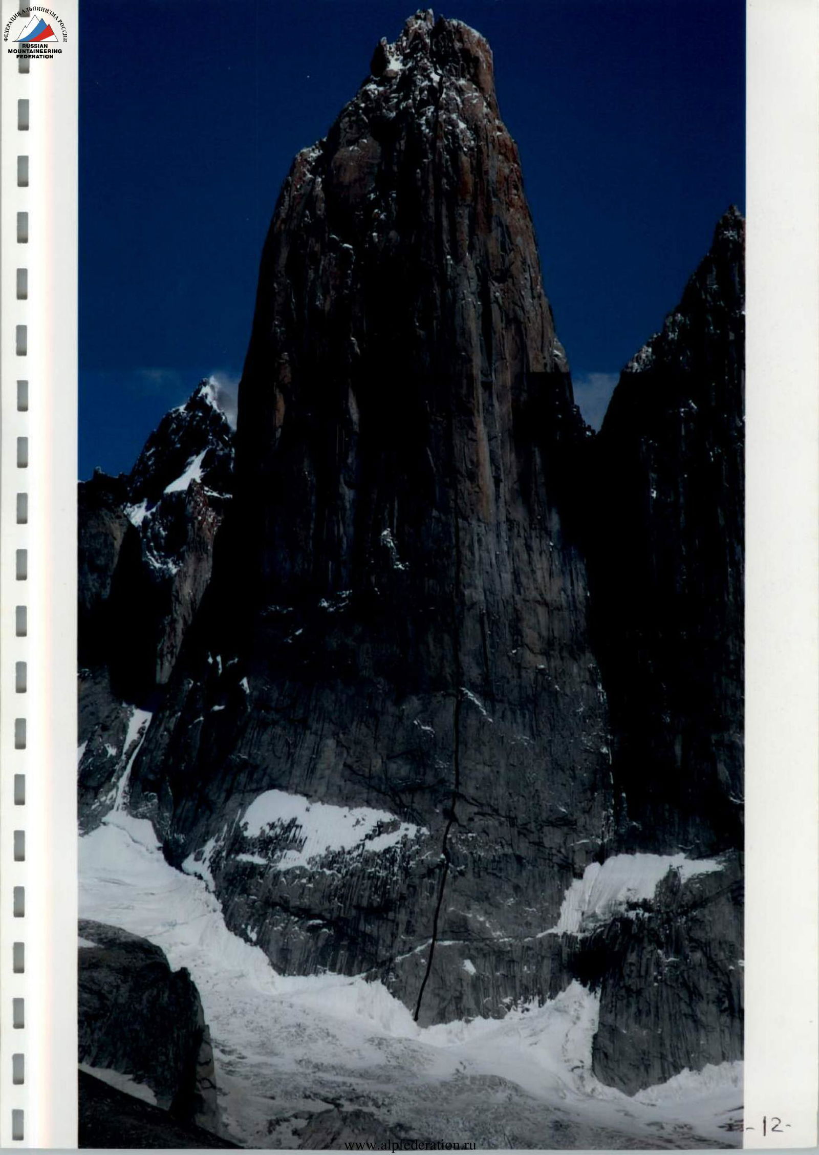
Central Tower of Torres del Paine, "Golazo" Route, 6B, 2007
Passport
- Technical category
- South America, Chile, Patagonia
- Summit: Torres del Paine, Central Tower
- Route: via center of the eastern wall ("Golazo"), Second ascent
- Cat. complexity 6B
- Elevations:
Route start elevation (above sea level) — 1600 m Summit — 2800 m Elevation gain — 1200 m
- Length of section with 90° steepness (R6–R19) — 795 m
- Length of sections with 6th category complexity — 905 m
- Route length — 1277 m
- Equipment used:
Friends — 274 pcs Stopper — 276 pcs Rock anchors — 457 pcs Copperhead — 158 pcs Skyhook — 78 pcs Spits — 10 pcs Ice anchors — 2 pcs Aliens — 269 pcs BIX — 72 pcs RURP — 49 pcs CamHuk — 48 pcs Static rope 6 × 60 m — 360 m Dynamic rope 6 × 65 m — 390 m
- Total hours including route preparation — 274
- Route preparation start: January 14, 2007
Summit attempt: February 2, 2007
Return to base camp: February 3, 2007
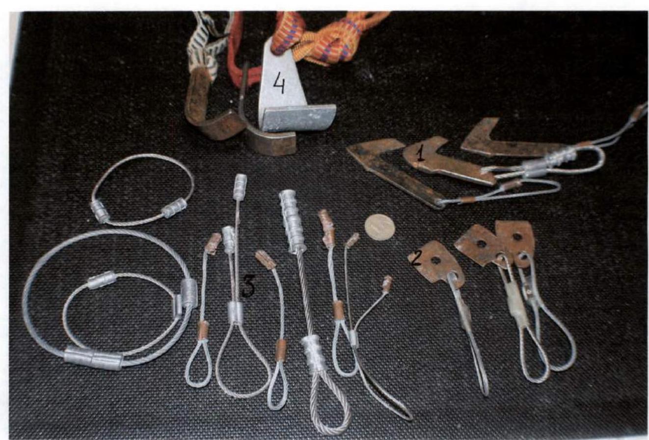
Equipment
1 — BIX; 2 — RURP; 3 — Copperheads; 4 — CamHooks
Central Tower of Torres del Paine (2800 m)
Patagonia is a mountainous region stretching 1770 km from the Magellan Strait along the Pacific coast of South America to the north. Patagonia is the only landmass on Earth fully exposed to the circumpolar movement of air masses. Cold air masses flowing from the Antarctic dome at 40–50° south latitude, colliding with air flows from equatorial zones, create a special "roaring forties" zone. Hurricane-force winds sweep around the Earth unobstructed, encountering no barriers except for the narrow strip of land that is Patagonia. The cold Humboldt Current, flowing from Antarctica along the western coast of South America, significantly influences weather formation in this region. From Alan Kearney's "Climbing in Patagonia" (Seattle, 1993):
- Due to Patagonia's unique location as the only obstacle to air mass movement in the 40–50° "roaring forties" zone, Patagonia experiences 80 days per year with wind speeds of 79 km/h.
- Winds at 150–200 km/h are not uncommon.
- Good weather is an exceptional state in Patagonia; for example, according to Climbing magazine, during the summer season from November 2000 to February 2001, good weather lasted only 12 hours.
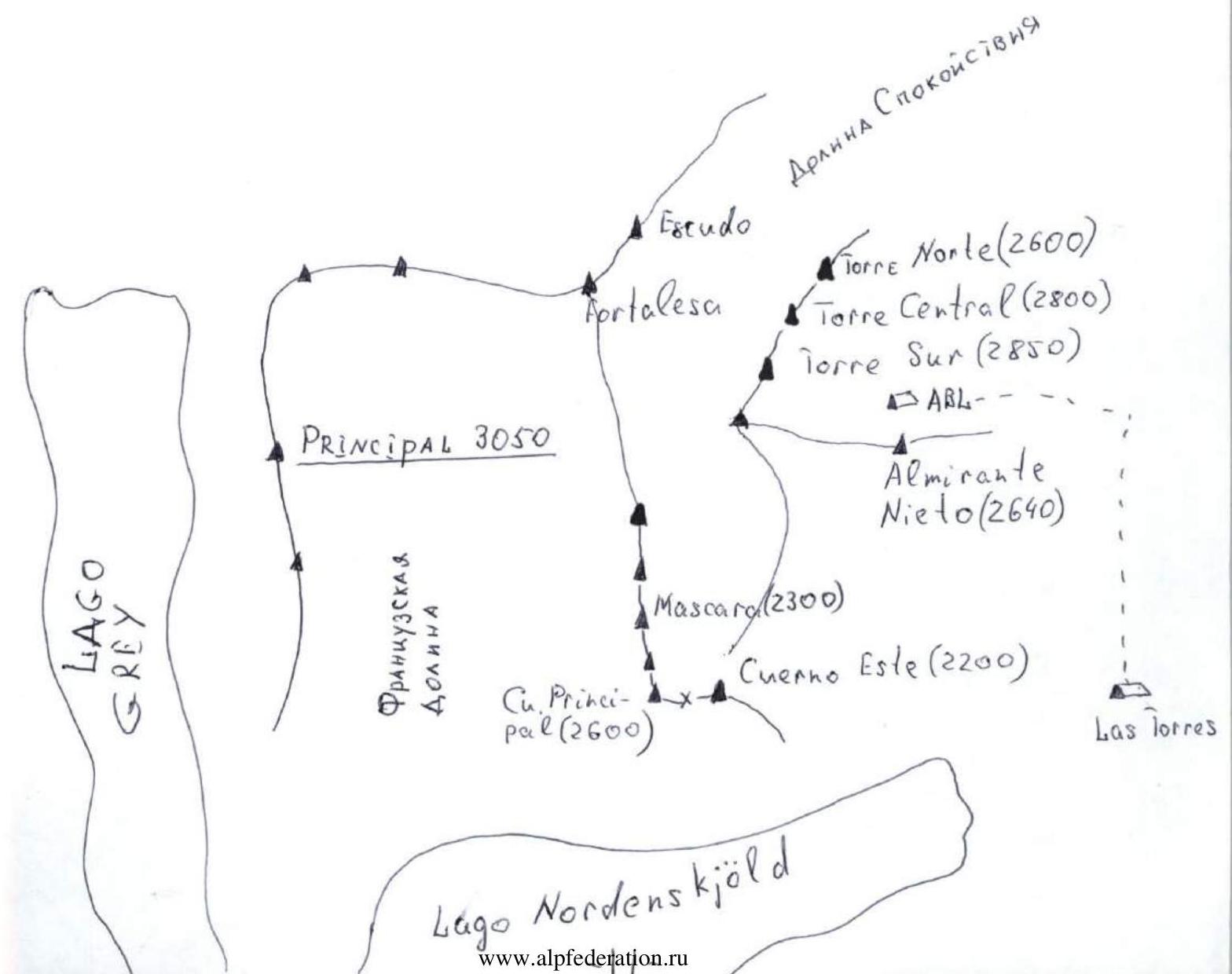
The Torres del Paine massif is located 112 km from the settlement of Puerto Natales, which is 250 km from Punta Arenas, situated near the Magellan Strait. To the west of Torres del Paine lies the 400 km long, 100 km wide Hielo Sur glacier with an ice cover thickness of up to 2 km. To the east of Torres del Paine lies a plain (pampa) stretching to the Atlantic Ocean coast.
The Torres del Paine towers are primarily composed of granite, but there are inclusions of black amorphous sedimentary rocks. These inclusions are very fragile and difficult to traverse (the two Cuerno peaks are capped with these rocks).
The photo below demonstrates the strength of Patagonian granite.
The dominant factor in shaping the local climate is the humid westerly wind, cooled over the Hielo Sur glacier. Notably, during the summer, a local "shower" wind develops in the sun-heated valleys against the backdrop of the constantly blowing westerly wind, with local wind speeds reaching 150–160 km/h.
During their stay in the region, the team attempted to follow weather forecasts. It turned out that the forecasts issued by CNN for Puerto Natales did not match the weather in the Torres del Paine area. Observations showed that there was no more than a 6-hour gap between the appearance of signs indicating deteriorating weather and their actual manifestation.
In 2007, the El Niño phenomenon was observed, typically accompanied by a sharp warming of air masses in the Southern Hemisphere. However, in 2007, it also resulted in an intensification of Patagonian winds and a deterioration of the already poor weather.
On the first night, the team's expedition tent "Marmot" was damaged by strong winds in the base camp. During the approach from the base camp to the forward camp, Arkady Seregin was blown off the trail by a gust of wind; the team captain was "stabilized" by a heavy backpack. Subsequently, the expedition members developed a tactic for moving along the trail:
- Upon approaching a gust of wind, one must press against the ground and grab onto rocks or bushes.
Civilian tourists staying at a 5-star hotel and hiking to the lake below Torres del Paine followed the same methodology: they simply fell flat on the trail and grabbed onto rocks!!! When setting up the forward base camp tent, the team had to:
- dig a pit
- build a circular stone wall for wind protection
The platforms on the wall had to be additionally secured with guy lines. When deploying the platform for the climbing team, it was loaded with water containers and other weights to increase its stability against gusts of wind from below. One night, the wind lifted the platform with Akhmedhanov and Pehtereav and rotated it 180°, with the guy lines failing to save it.
The eastern exposure of the wall protected the team from the harsh westerly Patagonian wind, but wind was always present on the wall. At the base, wind speeds reached 150–160 km/h; the team could not estimate the wind speed on the wall but noted that it was stronger at higher elevations, even on the leeward side.
Debris blown from the ridge between the Central and North towers fell onto the route line at the base of the wall, posing a potential hazard when passing sections R0–R7.
During their time on the wall, the team "got used" to the wind: being blown off the route while moving on fixed ropes was not considered a reason to halt progress.
Since the wall featured numerous "living" rock formations, the fixed ropes were constantly getting jammed, causing significant difficulties for the team when moving up and down.
The constant wind and high air humidity created major issues for the belayer. The team had to use a haul bag (houl-bag) on the belay stations, into which the belayer would climb up to their waist (see photo — Kovalev belaying at station R14).
High air humidity also led to the freezing of carabiners, friends, and Aliens. The team had to lower friends and Aliens to the platforms at night for drying. "It is advisable to lubricate friends and carabiners with antifreeze liquid before the ascent."
The "Golazo" route was first ascended in 1999 by American climber Steve Schneider with partner Christian Santilices. ("Golazo" is the name of a brand of sweet bars containing nuts, grain, and dried fruits.)
By the time Schneider climbed "Golazo," he had:
- completed 55 routes on El Capitan
- achieved 2 first ascents
- completed 3 solo ascents
- set 8 speed records
After 5 weeks on the route, Christian Santilices decided to stop the ascent and descended, while Schneider continued solo. Schneider spent an additional 18 days on the wall, successfully completing the project.
The "Golazo" route bears some resemblance to El Capitan's "Retisient Wall" (A5):
- Extended 55–60 m complex sections
- Not always logically placed belay stations (it would have been more convenient to place them 3–4 meters lower, but this was not done)
- Starting from station R9 (ledge), the rating of sections was done according to the "new wave" principle, where a section rated A2 can be equivalent to a section rated A3 on a traditional route (for example, the team spent 30 working hours on section R10, which could be rated A4)
- Section R11 was rated A4+ by Steve Schneider, but in the topo scheme sent to Seregin, he revised the rating to A5 (see photocopy on page 14)
- The team increased the rating of sections R19, R20, and R21 from A2 to A2+ because the main crack in the internal corner was completely filled with ice, and they had to traverse the right edge with a system of micro-cracks using Copperheads, RURPs, and BIXs, typically used for sections rated A3
To date, "Golazo" is considered the most technically challenging route in South America.
There is no water on the wall, so the team had to haul 150 liters of water in 5-liter containers to the ledge (R9). Water was collected from the lower part of the glacier.
Despite the presence of 18 routes on the three Torres del Paine towers, this region cannot be considered a frequently visited climbing destination. According to publications:
- the "Riders on the Storm" route on the Central Tower has been repeated several times;
- the British route "El Regalo del Mwoma" has been repeated twice;
- in 2004, a South African team repeated the South African route (30 years after its first ascent).
The traditional route to the summit of the Central Tower is the Bonington route, which starts on the western slope in the Valley of Tranquility and is half the length of the routes on the eastern wall. The other routes on the Central Tower have not been repeated.
A Czech team was working on the "Riders on the Storm" route on the eastern wall of the Central Tower simultaneously with the Russian team but abandoned the ascent due to strong winds and ice.
Logistics
The team flew from Moscow to Santiago (Chile) on the "Iberia" airline. From Santiago to Punta Arenas, they took a domestic flight lasting 4 hours. From Punta Arenas to Puerto Natales, they traveled by bus for 2 hours. From Puerto Natales to the base camp in Torres del Paine National Park, they took a car for 3 hours.
All products can be purchased in Puerto Natales.
To climb in Chile, one must:
- Obtain a permit in Santiago from Dirección de Fronteras y Límites (DIFROL);
- Then obtain permission from the Torres del Paine National Park office (CONAF).
The permit acquisition process should start a month before arriving in the region. The entire permit acquisition process, as well as visa support, was handled by the "Antares Patagonia" company from Puerto Natales (www.antarespatagonia.com ↗).
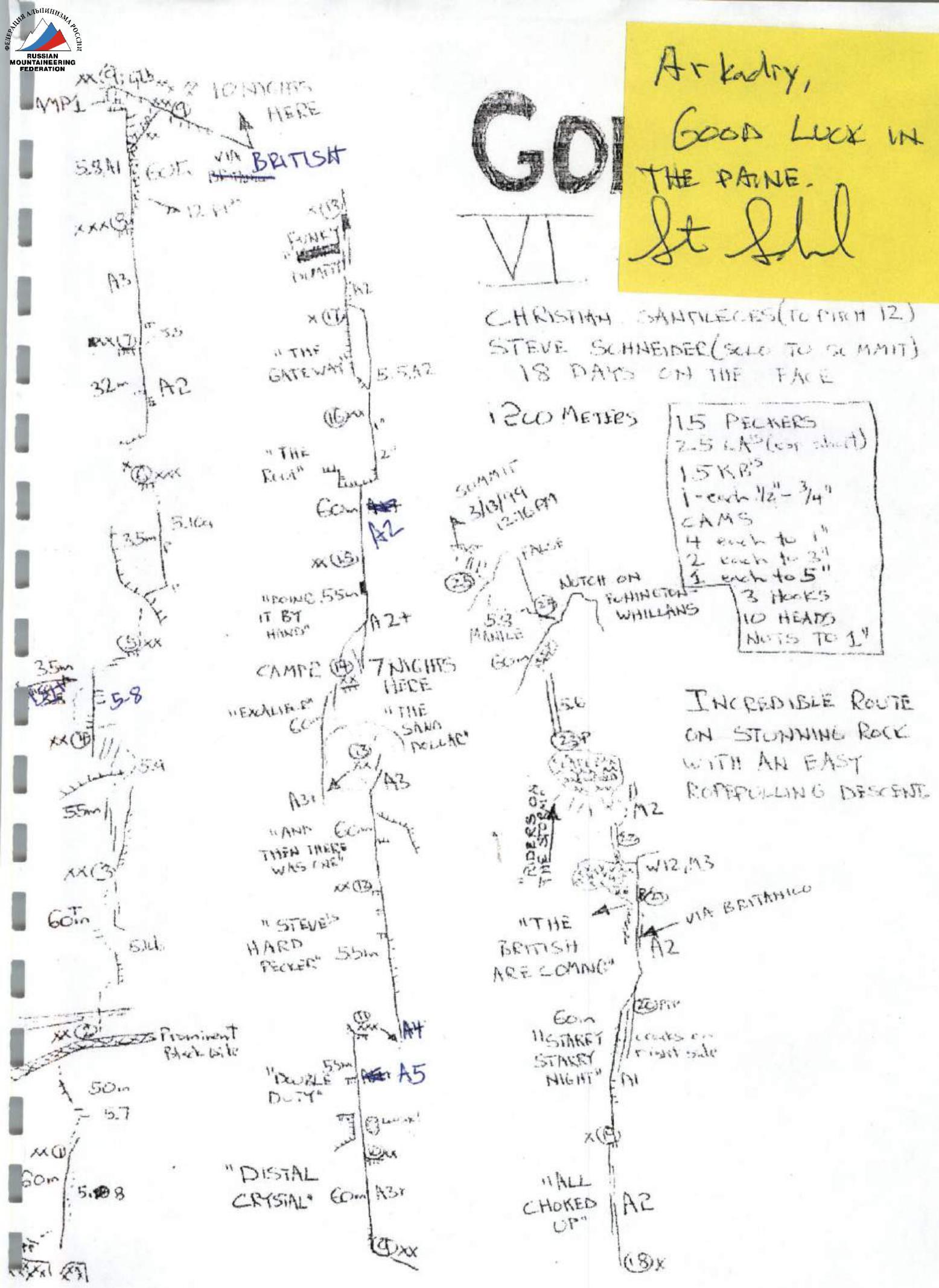
"Golazo" Route Diagram sent by Steve Schneider
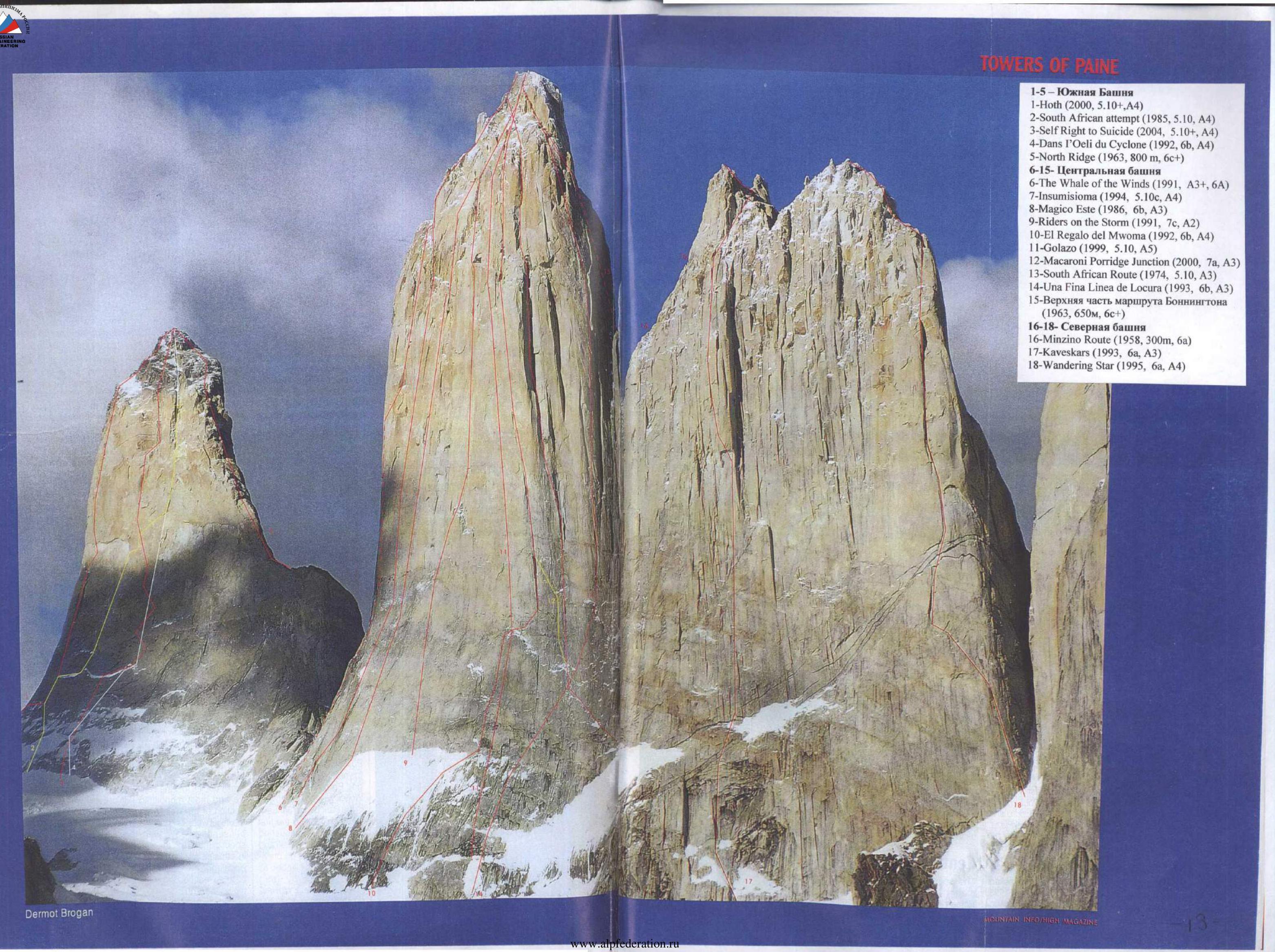
1–5 — South Tower
- "Hoth" (2000, 5.10+, A4)
- "South African attempt" (1985, 5.10, A4)
- "Self Right to Suicide" (2004, 5.10+, A4)
- "Dans l'Oeil du Cyclone" (1992, 6B, A4)
- "North Ridge" (1963, 800 m, 6C+)
6–15 — Central Tower 6. "The Whale of the Winds" (1991, А3+, 6А) 7. "Insumisiona" (1994, 5.10c, А4) 8. "Magico Este" (1986, 6Б, А3) 9. "Riders on the Storm" (1991, 7C, А2) 10. "El Regalo del Mwoma" (1992, 6Б, А4) 11. "Golazo" (1999, 5.10, А5) 12. "Macaroni Porridge Junction" (2000, 7А, А3) 13. "South African Route" (1974, 5.10, А3) 14. "Una Fina Línea de Locura" (1993, 6Б, А3) 15. Upper part of Bonington's route (1963, 650 m, 6C+)
16–18 — North Tower 16. "Minzino Route" (1958, 300 m, 6А) 17. "Kaveskars" (1993, 6А, А3) 18. "Wandering Star" (1995, 6А, А4)
| Section number | Length (m) | Difficulty category | Equipment used | Quantity | Note | Date |
|---|---|---|---|---|---|---|
| R0–R1 | 60 | 5.8 | Stopper | 8 | 14.01 | |
| Friend | 9 | |||||
| Alien | 7 | |||||
| R1–R2 | 50 | 5.8 | Stopper | 7 | 14.01 | |
| Friend | 5 | |||||
| Alien | 8 | |||||
| R2–R3 | 60 | 5.9 | Rock anchor | 5 | 14.01 | |
| Stopper | 6 | |||||
| Friend | 5 | |||||
| Alien | 5 | |||||
| R3–R4 | 55 | 5.9 | Rock anchor | 4 | 14.01 | |
| Stopper | 7 | |||||
| Friend | 8 | |||||
| Alien | 3 | |||||
| R4–R5 | 35 | 5.8 | Rock anchor | 3 | 15.01 | |
| Stopper | 4 | |||||
| Friend | 3 | |||||
| Alien | 4 | |||||
| R5–R6 | 35 | 5.10 | Rock anchor | 4 | 15.01 | |
| Stopper | 4 | |||||
| Friend | 2 | |||||
| Alien | 6 |
Torre del Paine Central Tower "Golazo" (5.10 A5) 14.01–03.02.07
| R6–R7 | 32 | А2 | Rivet hangers | 8 | 17.01 | |
|---|---|---|---|---|---|---|
| Rock anchor | 12 | |||||
| Stopper | 15 | |||||
| Friend | 3 | |||||
| Alien | 7 | |||||
| R7–R8 | 40 | А3 | Copperhead | 9 | 50% of the section processed | 17.01, 19.01 |
| Rock anchor | 21 | on January 17, continued on | ||||
| Stopper | 15 | January 19. | ||||
| Friend | 6 | |||||
| Alien | 12 | |||||
| Skyhook | 6 | |||||
| R8–R9 | 60 | А1 | Rock anchor | 16 | Reached the ledge, installed | 19.01 |
| Stopper | 19 | a platform | ||||
| Friend | 23 | |||||
| Alien | 13 | |||||
| Bolt | 4 | |||||
| R9–R10 | 60 | А3+ | Copperhead | 28 | Section processed over 2 days | 20.01–21.01 |
| BIX | 7 | |||||
| CamHuk | 5 | |||||
| Skyhook | 8 | |||||
| Alien | 19 | |||||
| Stopper | 24 | |||||
| Rock anchor | 35 | |||||
| R10–R11 | 55 | А5 | Copperhead | 19 | Section processed over 2 days | 24.01–25.01 |
| Rock anchor | 34 | |||||
| Skyhook | 18 | |||||
| Alien | 6 | |||||
| Stopper | 8 | |||||
| Friend | 6 | |||||
| BIX | 8 | |||||
| RURP | 9 | |||||
| R11–R12 | 55 | А4+ | Copperhead | 24 | Processing started on | 25.01–26.01 |
| Rock anchor | 32 | January 25, completed on | ||||
| RURP | 12 | January 26 | ||||
| BIX | 16 | |||||
| CamHuk | 11 | |||||
| Alien | 8 | |||||
| Skyhook | 18 | |||||
| R12–R13 | 60 | А3+ | Copperhead | 19 | Processing started on | 26.01–28.01 |
| Rock anchor | 52 | January 26, continued on | ||||
| RURP | 9 | January 27, completed on | ||||
| BIX | 12 | January 28 | ||||
| CamHuk | 8 | |||||
| Alien | 7 | |||||
| Skyhook | 12 | |||||
| R13–R14 | 60 | А3+ | Copperhead | 23 | Processing started on | 28.01–29.01 |
| Rock anchor | 36 | January 28, completed on | ||||
| RURP | 13 | January 29 | ||||
| BIX | 15 | |||||
| CamHuk | 8 | |||||
| Alien | 7 | |||||
| Skyhook | 16 | |||||
| Friend | 8 | |||||
| R14–R15 | 55 | А2+ | Copperhead | 12 | Processing started on | 29.01–30.01 |
| Rock anchor | 36 | January 29, completed on | ||||
| CamHuk | 8 | January 30 | ||||
| BIX | 8 | |||||
| Alien | 12 | |||||
| Stopper | 10 | |||||
| Friend | 13 | |||||
| R15–R16 | 60 | А2 | Copperhead | 9 | Processing started on | 30.01–31.01 |
| Rock anchor | 37 | January 30, completed on | ||||
| CamHuk | 8 | January 31 | ||||
| Alien | 24 | |||||
| Stopper | 19 | |||||
| Friend | 24 | |||||
| Bolt | 1 | |||||
| R16–R17 | 60 | А2 | Friend | 21 | 31.01 | |
| Rock anchor | 17 | |||||
| Stopper | 19 | |||||
| Alien | 12 | |||||
| Bolt | 1 | |||||
| R17–R18 | 55 | А2 | Friend | 13 | Processing started on | 31.01–01.02 |
| Rock anchor | 24 | January 31, completed on | ||||
| Stopper | 22 | February 1 | ||||
| Alien | 17 | |||||
| Bolt | 1 | |||||
| R18–R19 | 50 | А2+ | Friend | 16 | 01.02 | |
| Rock anchor | 16 | |||||
| Copperhead | 15 | |||||
| RURP | 6 | |||||
| BIX | 6 | |||||
| Stopper | 20 | |||||
| Alien | 18 | |||||
| Bolt | 1 | |||||
| R19–R20 | 50 | А2+ | Friend | 19 | Processing started on | 01.02–02.02 |
| Rock anchor | 23 | February 1, completed on | ||||
| Stopper | 19 | February 2. Main crack filled | ||||
| Alien | 17 | with ice, traversed right | ||||
| Bolt | 1 | part of internal corner | ||||
| R20–R21 | 50 | А2+ | Friend | 18 | Similar to previous section | 02.02 |
| Rock anchor | 25 | |||||
| Stopper | 20 | |||||
| Alien | 18 | |||||
| Bolt | 1 | |||||
| R21–R22 | 45 | А2 | Friend | 15 | 02.02 | |
| Rock anchor | 24 | |||||
| Stopper | 19 | |||||
| Alien | 16 | |||||
| R22–R23 | 40 | 5.6, М2 | Friend | 14 | 02.02 | |
| Stopper | 12 | |||||
| Alien | 8 | |||||
| Ice anchor | 2 | |||||
| R23–R24 | 60 | 5.6 | Friend | 8 | 02.02 | |
| Stopper | 12 | |||||
| Alien | 7 | |||||
| R24–R25 | 35 | 5.6 | Friend | 8 | 02.02 | |
| Stopper | 7 | |||||
| Alien | 4 | |||||
| Total | 1277 | Friends | 247 | |||
| Aliens | 269 | |||||
| Rock anchors | 457 | |||||
| Bolts | 10 | |||||
| Copperheads | 158 | |||||
| Ice anchors | 2 | |||||
| BIX | 72 | |||||
| RURP | 43 | |||||
| CamHuk | 48 | |||||
| Stoppers | 276 | |||||
| Skyhooks | 78 | |||||
| Rivet hangers | 8 |
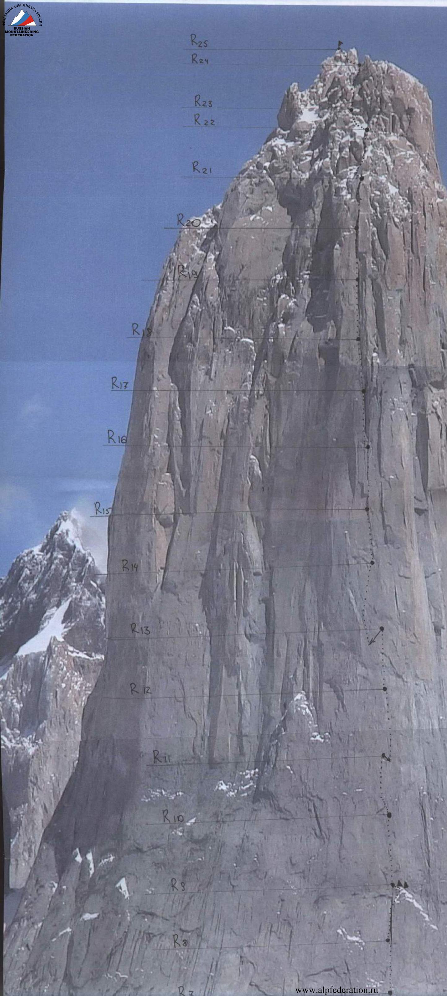
Route Description by Section
The approach to the start of the route takes 3 hours from the ABC tent, set up in front of the moraine ridge below the glacier. Moving across the glacier does not pose significant problems.
Sections R0–R7 are potentially hazardous due to:
- falling rocks
- falling ice
- wind blowing debris from the summit ridge
R0–R1. 60 m of rock climbing with a 70° slope along a watercourse. The belay station is set up on two bolt anchors (sections R1–R9 coincide with the descent stations of the British route "El Regalo del Mwoma"). The section is climbed free solo in rock shoes (difficulty 5.8).
R1–R2. Movement upwards 50 m to a broad destroyed ledge. The belay station is set up above a black band 1–2 m wide. The section is climbed free solo (5.8, 70°).
R2–R3. 60 m along an internal corner transitioning into slabs. The section is climbed free solo (5.9, 75°).
R3–R4. Movement towards a cornice 55 m. The belay station is located on the right side of the cornice. Climbed free solo (5.9, 80°).
R4–R5. Movement from the station left over the cornice towards Schneider's descent station (which had thawed by the time the team descended!). From a snowdrift up the wall (10 m is climbed using artificial aids). Cracks are filled with ice.
- Section length: 35 m
- Difficulty: 5.8 (A2)
- Angle: 80°
At station R5, the "Golazo" route coincides with the "El Regalo del Mwoma" route, which approaches from the left.
R5–R6. 35 m along an overhanging internal corner under the cornice. Climbed free solo (5.10). The station is located under the cornice.
R6–R7. Vertically up. The cornice is traversed using rivet hangers and bolts installed by the British team on the "El Regalo del Mwoma" route. Then along a crack. Length of section: 32 m. Difficulty: A2.
R7–R8. Movement vertically up 40 m along a blind crack. Copperheads and skyhooks are used. Difficulty A3.
R8–R9. Movement along an internal corner. After 40 m, the route transitions to the right side of the internal corner, then vertically up the wall to a destroyed ledge. Section difficulty A1, length 60 m. Many loose blocks are present at the top of the section, posing a hazard.
On the ledge, camps were established:
- by the British team
- by Steve Schneider's team
After the ledge:
- the British route goes 30 m to the right into an internal corner
- the "Golazo" route goes vertically up along a vague blind crack
The team set up a camp on the ledge using two platforms.
R9–R10. Movement along a blind crack. 60 m, difficulty A3+. Many copperheads and skyhooks were used. The section took 30 working hours to complete.
From R10 to R15, belay stations with two bolt anchors each were installed by Steve Schneider. From R16 to R22, one bolt anchor was installed per station, so the team added an extra anchor.
R10–R11. Initially rated A4+ by Steve Schneider, later revised to A5. The team confirms the difficulty as A5.
From the belay station, movement is vertically up along a blind crack to an internal corner, then 5 m up the corner with a traverse left onto a ledge. From the ledge, movement is vertically up the wall. Very scarce features required the exclusive use of:
- copperheads
- RURPs
- BIXs
- skyhooks
A fall from this section could result in a 50–60 m drop and an inevitable impact on the ledge. The section took 24 hours to complete.
R11–R12. From the belay station, a pendulum traverse (R = 5 m) is made into a blind crack on the right. Then movement is along the blind crack, interrupted by three destroyed zones, which were traversed using skyhooks. Many copperheads, BIXs, RURPs, and CamHooks were used. Difficulty A4+. The section took 16 hours to complete.
R12–R13. Movement along a blind crack under a 80 cm overhang. Then continuation along the blind crack. The belay station is set up in the center of a monolithic wall, approached by a delicate route along the blind crack to the right and then traversing from right to left (photo 7). The station's location appears illogical during ascent but becomes clear on descent! Difficulty A3+. 60 m. Took 24 hours.
R13–R14. A pendulum traverse (R = 15 m) left into a blind crack. 20 m of upward movement (back-cleaning: the leader had to clean all protection points over 20 m), then continuation up the crack. The crack transitions into a series of "breathing" rock formations. Difficulty A3+. At R14, Steve Schneider set up a second hanging camp. The team chose not to do so, having sufficient rope for processing and summiting.
R14–R15. Movement along a destroyed crack towards an overhanging internal corner (100°, 10 m), then up a vertical internal corner into a chimney (8 m, max width 60 cm). The chimney, like the entire section, is climbed using artificial aids. After the chimney, movement is along a crack (black, blue, and green Aliens) to the belay station. 12 copperheads were used, not typical for a section rated A2+, as they were used instead of stoppers and were removed during descent. Ropes on this section were frequently blown into rock formations by the wind.
R15–R16. Movement along a crack towards a 2 m overhanging cornice. The cornice is traversed on the right via a crack (using green and red camalots), which is filled with ice. Then movement is along a crack (yellow, green camalots, orange and red Aliens, "Omega" friends) to the belay station.
R16–R17. Movement vertically up 10 m along a crack, then a traverse 7 m left and up free free-free solo (5.8) into the base of a giant internal corner. Movement is up along a crack. The crack is filled with ice in many places. Difficulty A2. The belay station is set up in the upper left part of the internal corner.
R17–R18. A traverse left from the belay station into a crack. Movement is up the crack to the belay station. The crack is filled with ice. The R18 belay station is the first convenient belay on the wall after the R9 ledge. Difficulty A2. From R18 to the summit, sections are critical due to rope jamming during descent.
R18–R19. Continuation up the ice-filled crack to the next belay station, also located in a convenient spot. Difficulty A2.
R19–R20. Continuation up the crack, which after 15 m transitions into an internal corner. The main crack is completely filled with ice, so the team traversed the right edge using copperheads, BIXs, and RURPs. The team rated this section A2+ compared to Schneider's A2.
R20–R21.
Comments
Sign in to leave a comment