Passport
-
Class: high-altitude
-
Indian Himalayas, Garhwal region
-
Changabang peak 6864 m, center of the North wall
-
Proposed 6B category of difficulty (first ascent)
-
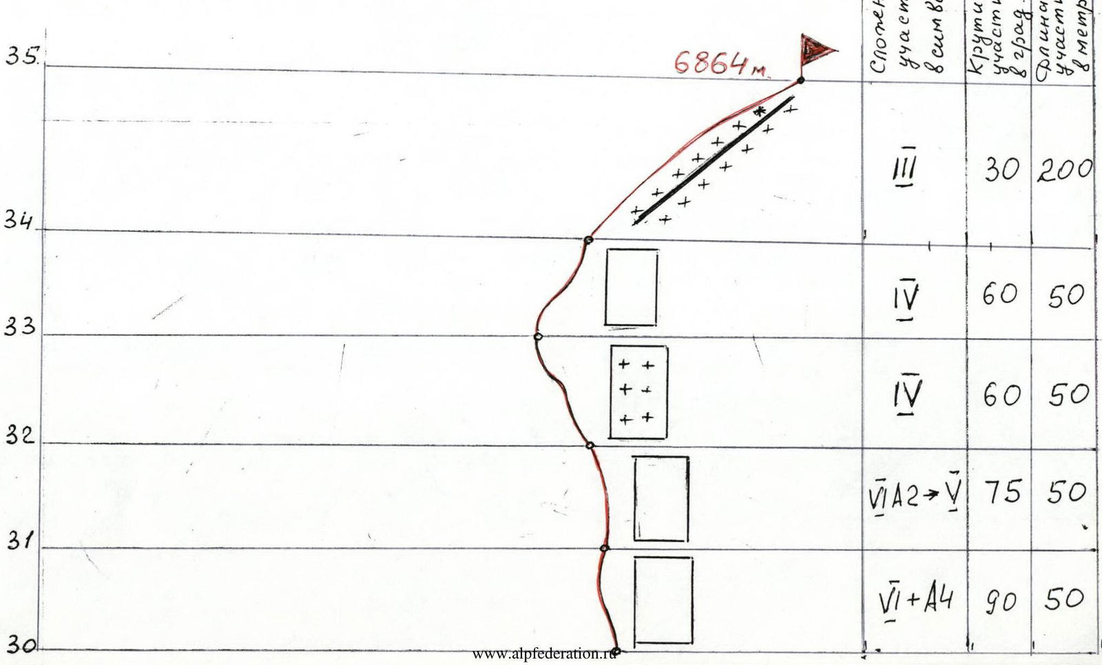
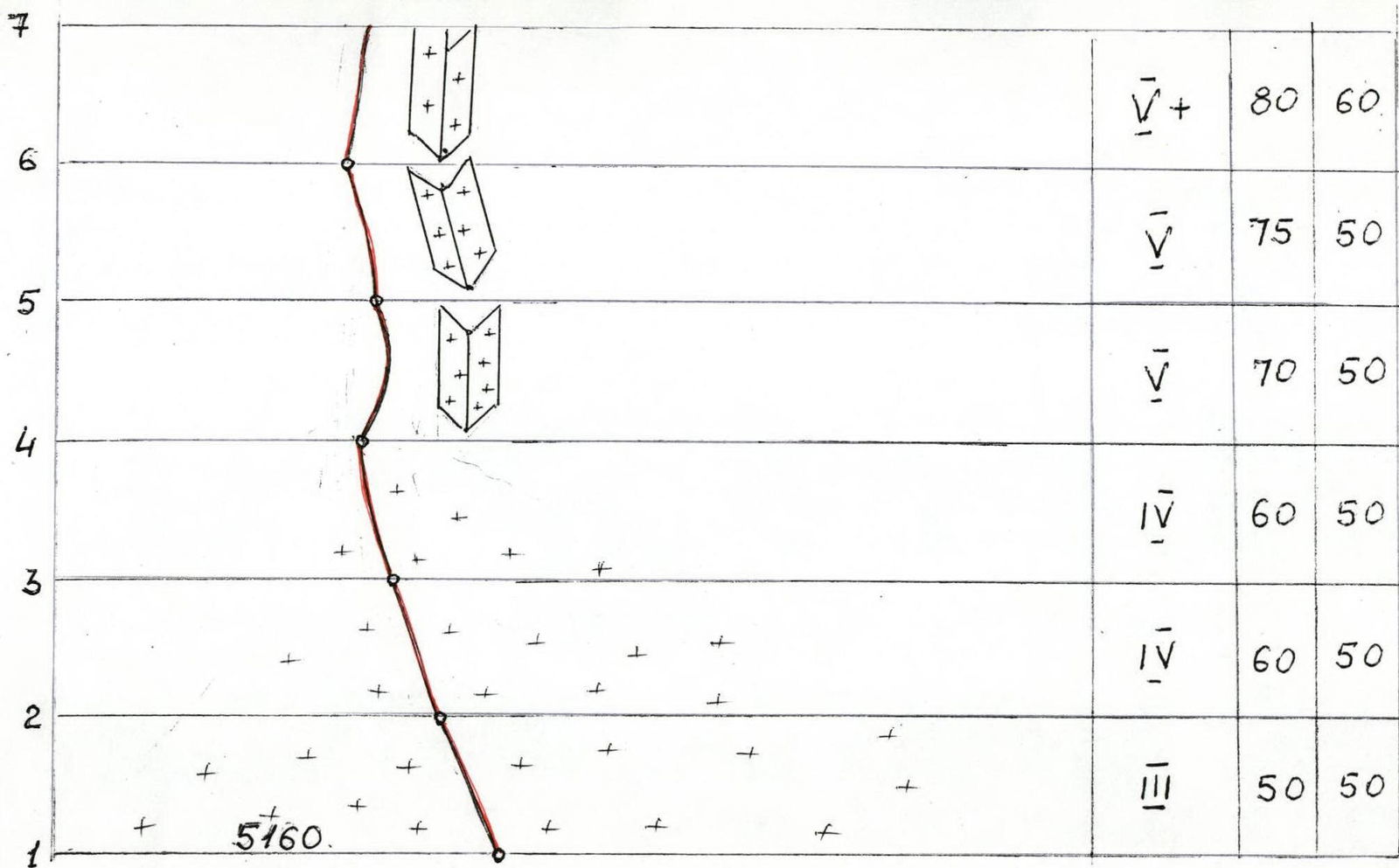
Height difference: from the bergschrund - 1700 m, length - 1900 m. Length of sections with 6B category of difficulty - 700 m. Average steepness of the main part of the route - 75° (from the bergschrund to the summit). Steepness of the wall section (from 5250 to 6800 m) - 79° (from the beginning of the rock wall to the flattening before the ridge)
-
Hooks left on the route (not removed): pitons - 40 (used for descent), ice screws - 5, rock screws - 2, chocks - 3. Previously hammered hooks used and not removed - none
-
Team's working hours - 198 (including processing and descent time)
-
Overnights: from May 16 to May 30 (15 overnights) on platforms, hanging
-
Team leader: Team members:
Dusharin Ivan Trofimovich – International Master of Sports Carlos Buler – professional climber – USA Mariev Andrey Nikolayevich – Candidate for Master of Sports Shabalin Pavel Eduardovich – International Master of Sports Volkov Andrey Evgenyevich – International Master of Sports
-
Coach:
Dusharin Ivan Trofimovich
-
Exit to the route: May 16 (May 5, 6, 13, 14 - processing) Return - May 31, 1998
-
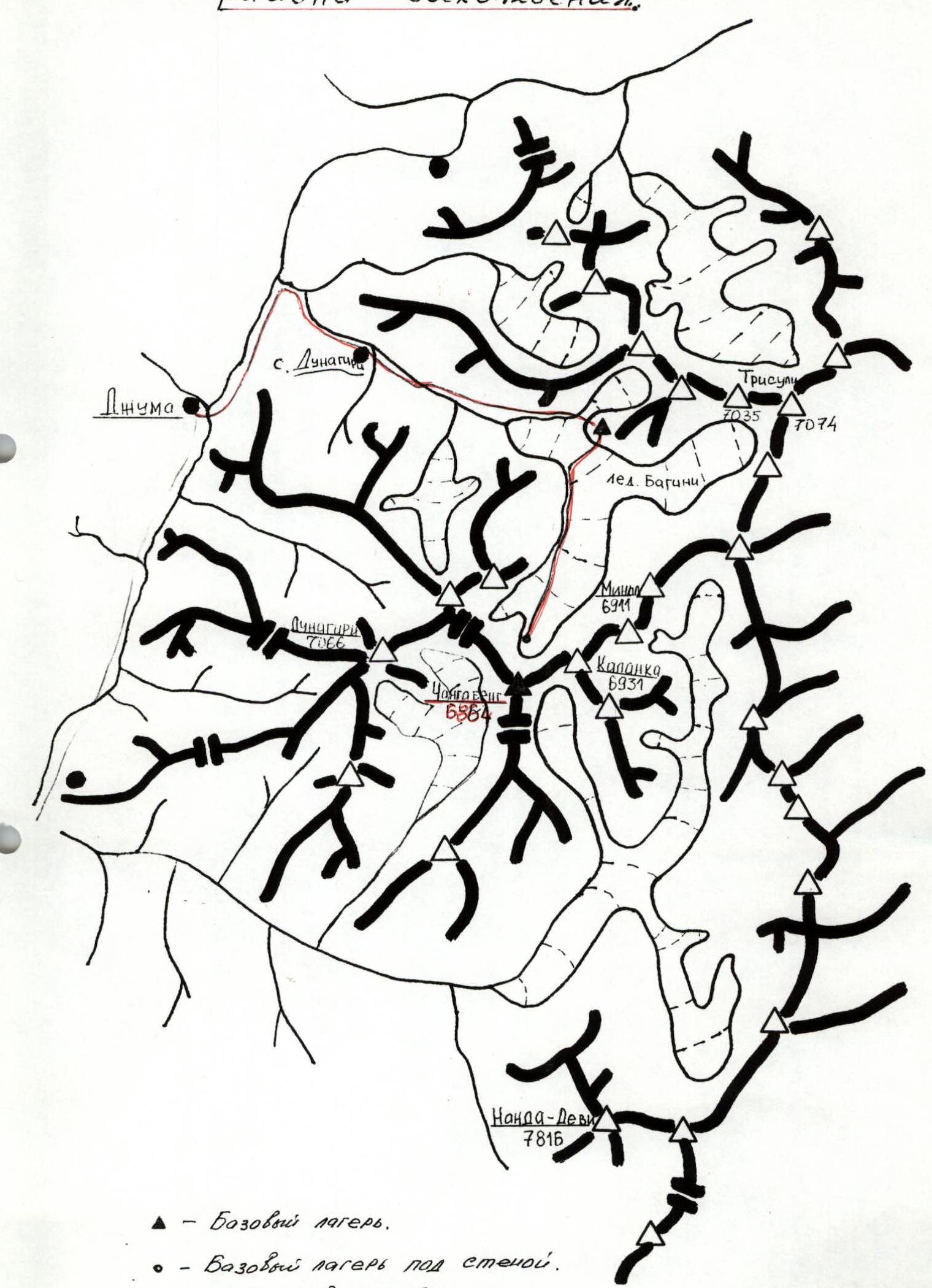
Conducting organization: "Lada-Everest" Ltd., Tolyatti. Map-scheme of the ascent area.
 Route profile.
  Route profile: Nuch-kov. 29.05.1998, 14:00. 6864 m. Sections: 34, 33, 32, 31, 30, 29, 28, 27, 26. 25, 24 - 6400 m (May 24, 25, 26, 27, 28, 29). 23, 22, 21, 20. 19, 18, 17 - 6100 m (May 19, 20, 21, 22, 23). 16. 15 - 5950 m (May 30, on descent). 14, 13, 12. 11 - 5750 m (May 16, 17, 18). 9, 8, 7, 6, 5, 4, 3. 2, 1 - 5160 m. www.alpfederation.ru↗. 1 cm = 63 m.
Location and Features of the Ascent Area
The Changabang peak is located in the Indian Himalayas, Garhwal region. The highest point of the region is Nanda Devi peak - 7816 m. Travel from Delhi to the town of Joshimath by car takes 2 days (scheduled bus takes 36 hours). In Joshimath, it's possible to buy fresh vegetables and products for the base camp.
From Joshimath, by car to the village of Djuma - 3-4 hours. On the way, there's an observation point with a beautiful panorama of the Himalayas and Nanda Devi peak in good weather. From Djuma village, across the river bridge and then along the trail to the summer village of Dunagiri - 1 day's walk. The trail initially goes through the forest, then along the talus slopes to the village, where they usually spend the night.
From Dunagiri to the base camp - a long and difficult day's walk. Porters with a 25 kg load may not make it in one day. If there's snow on the Bagini glacier, it's necessary to make a path in the snow for the porters. The base camp is located in a small valley formed by the talus slopes (terminal moraine of the lateral glacier) and the moraine of the Bagini glacier, on the left side of the path, about 1 hour before the point where the glacier splits into right and left branches.
From the base camp, to the routes on Changabang from the north, you need to move towards the bifurcation of the Bagini glacier. Then cross the glacier and, on the right side of the glacier and slopes from Dunagiri peak, move upwards, to the point where the arm of the glacier from the slopes of Dunagiri peak flows in. From here, the path goes to the center of the glacier towards Changabang. In the center of the snow cirque, opposite the wall, you can set up an advanced camp.
The transition from the base camp to the advanced camp takes 4-5 hours, depending on acclimatization and, most importantly, the state of the snow. It's better to leave the base camp at 3:00-4:00 am. The descent takes 2-2.5 hours on unthawed snow.


Tactical Actions of the Team
The ascent was made in a "capsule" style. Initially, 10 ropes of the route were processed, then a team of 5 people and over 200 kg of cargo moved into the vertical world. Throughout the route, 3 overnight stays were organized, and life took place on 2 two-person A-5 platforms from North Face (size 110 × 180 cm). The platforms were hung in relatively safe places under the protection of cornice, somewhat away from the direction of movement, each on 2 blocked pitons Ø 10 mm. There was enough ice at the overnight stays for cooking.
The team had 3 dynamic and 8 static ropes from Marmut Ø 10 mm on the route. The set of "hardware" and various equipment and devices for working on the route and ensuring insurance was sufficient.
Movement was carried out by processing 8-10 ropes, and then relocating the camp higher, taking a full day to move. The rope teams worked in interaction, with a change of leaders; the most technically complex sections were first passed by Shabalin P.E. When processing the route, cargo was simultaneously moved using a block and jumar; often, the climbers used their own weight, the smoothed relief, and the steepness of the wall allowed this.
Part of the wall has exfoliating rocks and "rock pancakes" of various sizes, as if "glued" to the wall - this is dangerous. The relief of the route is very fragmented; there are practically no cracks in the middle part of the wall. In the lower and upper parts of the wall, the cracks are quartz-filled and ice-filled. The work of the leader requires great tension and accuracy. The relief is extremely complex, so most of the route was passed using artificial technical aids (IT). Each passed rope on the rock was fixed on a piton Ø 10 mm and blocked with other insurance elements. On ice, the rope was blocked on ice screws. On the rock, a piton was hammered every 50 m, subsequently used during the descent from the route.
There were no falls during work on the route. One participant was bruised on the hand by a falling stone, but this did not hinder progress on the route. The sun appears on the wall after 14:00 and disappears around 17:00 in good weather. In the second half of the day, the weather often deteriorates, with snow and strong wind. After the inner corner (i.e., after 10 ropes from the bergschrund), the route is safe from avalanches, snow flows, and falling stones. In the upper part of the wall, it's noticeably colder and windier.
During the expedition and ascent, there was no rescue team or support group due to financial constraints. The entire expedition and team consisted of 5 participants.
Route Scheme
Route Scheme (continued)

Route Scheme (continued)
Description of the Route by Sections
| Section # | Technical Characteristics | Difficulty of Section | Steepness of Section | Length of Section |
|---|---|---|---|---|
| R1–R4 | Through the bergschrund, exit to a steep ice slope. The bergschrund is passed along an avalanche cone-bridge. Movement in crampons. Insurance through ice screws. | 3 | 50° | 50 m |
| 4 | 60° | 50 m | ||
| 4 | 60° | 50 m | ||
| R4–R9 | Inner corner, covered with thin ice, a series of small rock cornices. Movement with the help of ice axe, insurance with pitons, chocks, friends. After 14:00, the wall is lit by the sun, water flows, ice and stones fly, working is dangerous. | 5 | 70° | 50 m |
| 5 | 75° | 50 m | ||
| 6 | 80° | 50 m | ||
| R9–R11 | Steep ice couloir with vertical walls 3-5 m, insurance with pitons, used ice screws. | 5 | 75° | 50 m |
| 5 | 80° | 60 m | ||
| R11–R12 | Crossing the ice couloir, sometimes stones and ice fly, then a not clearly defined inner corner with flow ice. Smoothed rock wall with small cornices, hanging blocks, in the upper part without relief, transition to an ice "icicle." Climbing on IT with the use of pitons. | 5 | 65° | 60 m |
| R12–R14 | 5 | 80° | 45 m | |
| 6 | 80° | 50 m | ||
| R14–R18 | Hard, frozen ice, steep, sometimes sheer. Insurance through ice screws with a carbide crown or steel (titanium doesn't work). Movement with ice tools. | 5 | 80° | 50 m |
| 5 | 80° | 50 m | ||
| 5 | 80° | 50 m | ||
| 5 | 80° | 50 m | ||
| R18–R21 | Traverse under a cornice to the right on ice, exit above the cornice. Then vertically upwards, smoothed rocks with practically no relief, completely passed on IT. Passage and insurance with the use of pitons and skyhooks. | 6 | 85° | 50 m |
| 6 | 90° | 50 m | ||
| 6 | 90° | 50 m | ||
| R21–R22 | Traverse to the right - upwards, along a not clearly defined crack in the direction of a rusty overhang, still moving only on IT, but already using chocks, friends, pitons. | 6 | 85° | 50 m |
| R22–R23 | Through a rock overhang into the inner corner. Along the inner corner through the left edge of a large, elongated to the right cornice. Passed on IT, the rock is not monolithic, exit to a smooth, sheer wall above the cornice. | 6 | 80° | 50 m |
| R23–R25 | Oblique traverse along a smooth wall with a series of "live" rock "slabs" in the direction of a large inner corner. At the base of the corner and above, rocks with flow ice. Extremely careful passage on IT, avoiding the "slabs." Serious problems with pulling out the cargo. | 5 | 75° | 50 m |
| 5 | 80° | 35 m | ||
| R25–R28 | A series of vertical inner corners with smooth walls and cornices, with sections of flow ice. Passed on IT, using friends, ice screws, chocks. | 6 | 75° | 50 m |
| 6 | 85° | 50 m | ||
| 6 | 90° | 50 m | ||
| R28–R29 | A large rock niche with cornices, rocks are rusty, cracks are destroyed, filled with flow ice. After fixing the rope, it sags 5-6 m from the wall. | 6 | 85° | 50 m |
| R29–R31 | Smooth wall with a slight overall overhang. Passed on IT, along a not clearly defined crack with embedded stones. | 6-5 | 75° | 50 m |
| 6 | 90° | 50 m | ||
| R31–R32 | Plate-like wall, about 30 m, ending with an inclined shelf (end of the vertical part of the route). Exit along sloping rocks to a steep ice slope between overhanging large rock "fingers." | 5 | 60° | 50 m |
| R32–R33 | Along a steep ice slope towards the saddle between the pre-summit rock "fingers." | 5 | 60° | 50 m |
| R33–R34 | Through a rock, smooth wall onto the saddle in the ridge. | 4 | 60° | 50 m |
| R34–R35 | Along a sharp snow ridge, through the right rock "finger," to the summit. | 3 | 30° | 200 m |
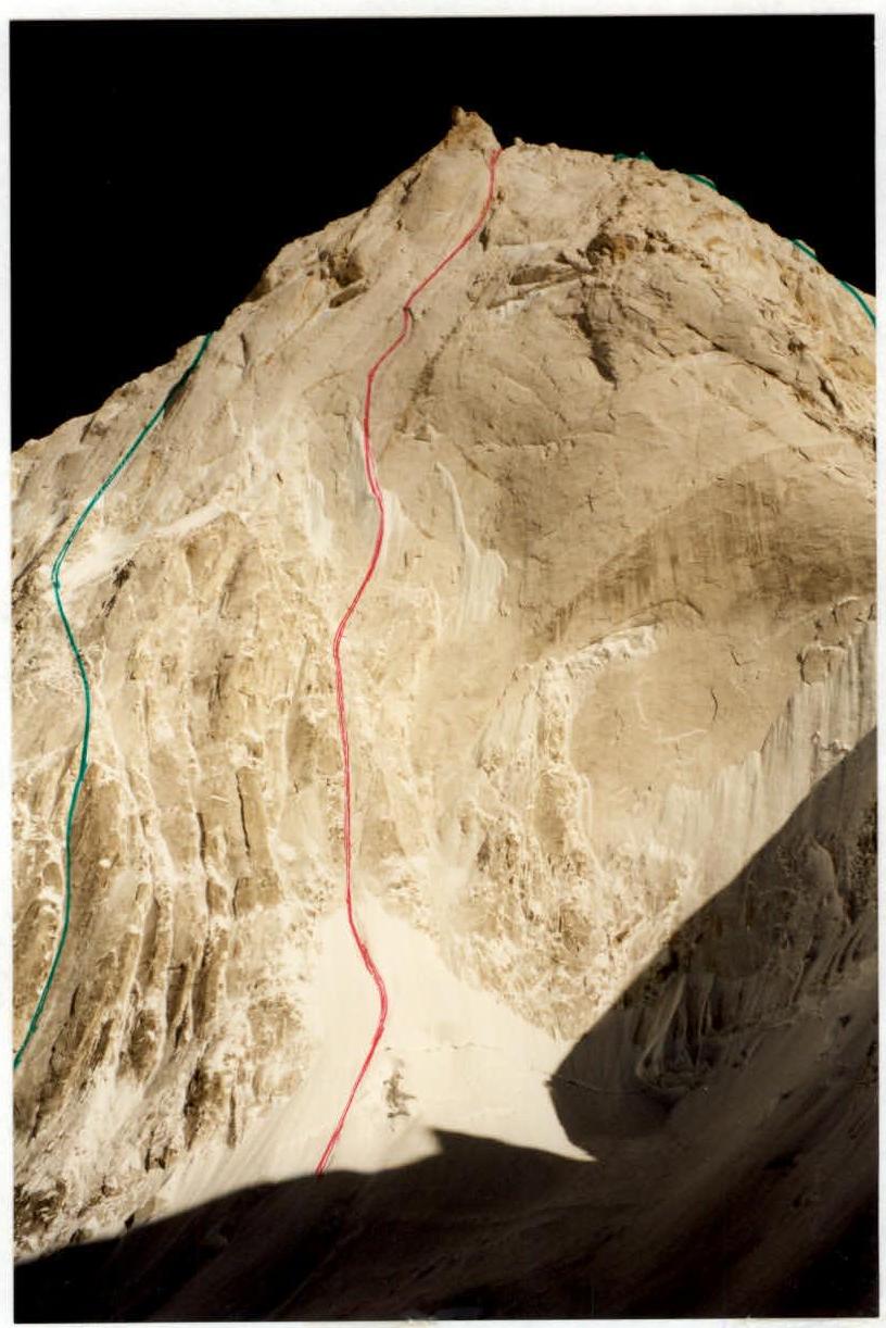
General view of the North wall. 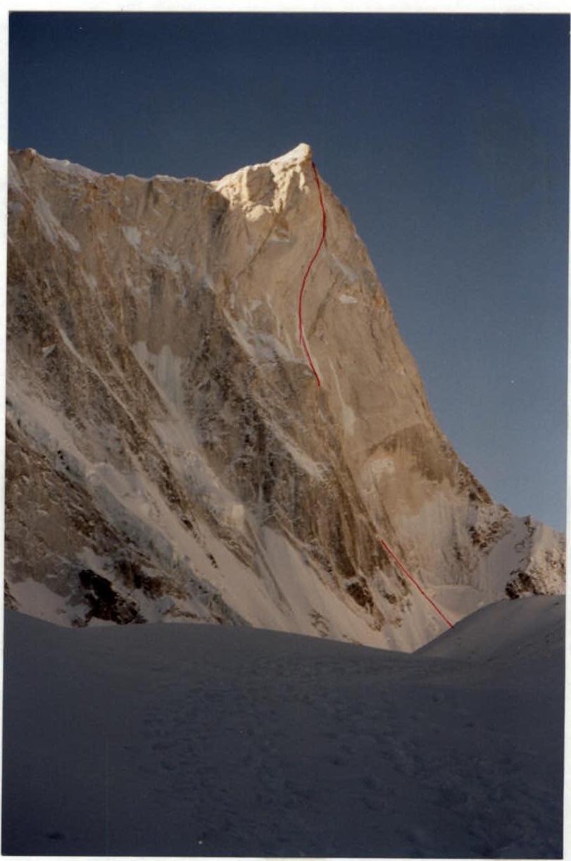
Route profile.