Ascent Certificate
- Region, gorge, classification table section number (2001) – 11.3
Mountain region: Kun-Lun (China, Xinjiang Uygur Autonomous Region), Muztagata massif
- Name of the peak: Koskulak (7028 m), route name:
via NW ridge
- Proposed – 5A category, first ascent
- Route type: snow-ice
- Route elevation gain: 2230 m (by altimeter and GPS)
Route length: 6060 m. Length of sections: V category – 360 m, VI category – 0 m. Average slope: main part of the route – 22°, including: 5200–5500 section – 35°, 6100–6200 section – 45°, entire route – 22°.
- Pitons left on the route: total 0, including bolted – 0
Pitons used on the route:
- rock – 0
- ice – 4, including ITO – 0
- snow – 0. Bolts (stationary, removable) were not used.
- Travel hours to the summit – 26 hours, total – 36 hours, days – 4.
- Leader:
Mikhail E. Volkov, Candidate for Master of Sports
Team members:
- Aleksandr I. Vorobyov, 1st sports category
- Andrei A. Mashenin, 1st sports category
- Natalia N. Ruleva, Candidate for Master of Sports
- Nikolai G. Sinyushin, Candidate for Master of Sports
- Igor E. Tarnavsky, 1st sports category
- Andrei E. Petrov, Candidate for Master of Sports, born 1948
- Coach: Andrei E. Petrov, Candidate for Master of Sports
- Departure to the route: 10:00 (Beijing time), August 10, 2005 Reached the summit: 18:00 (Beijing time), August 12, 2005 Returned to Base Camp: 16:00 (Beijing time), August 13, 2005
- Organization – MAI Sports Club

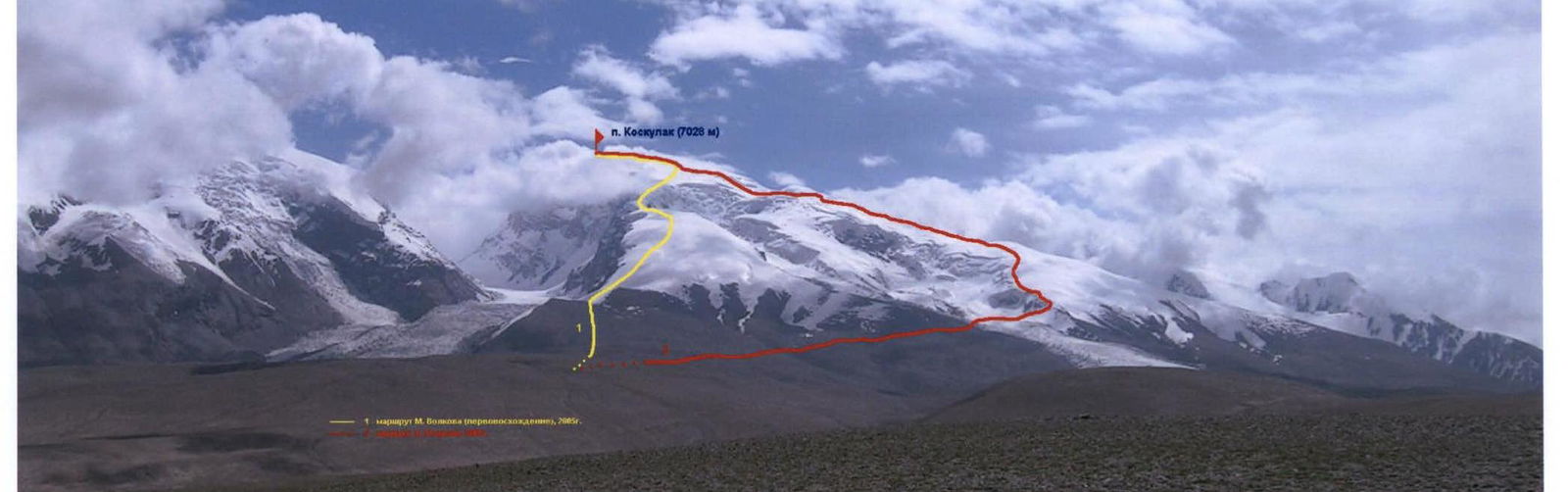
Photo #1 (A. Petrov), August 2005, from the slope above the 4400 m pass.
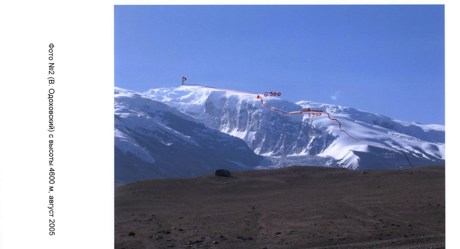
Photo #2 (V. Odokhovsky) from 4600 m, August 2005.

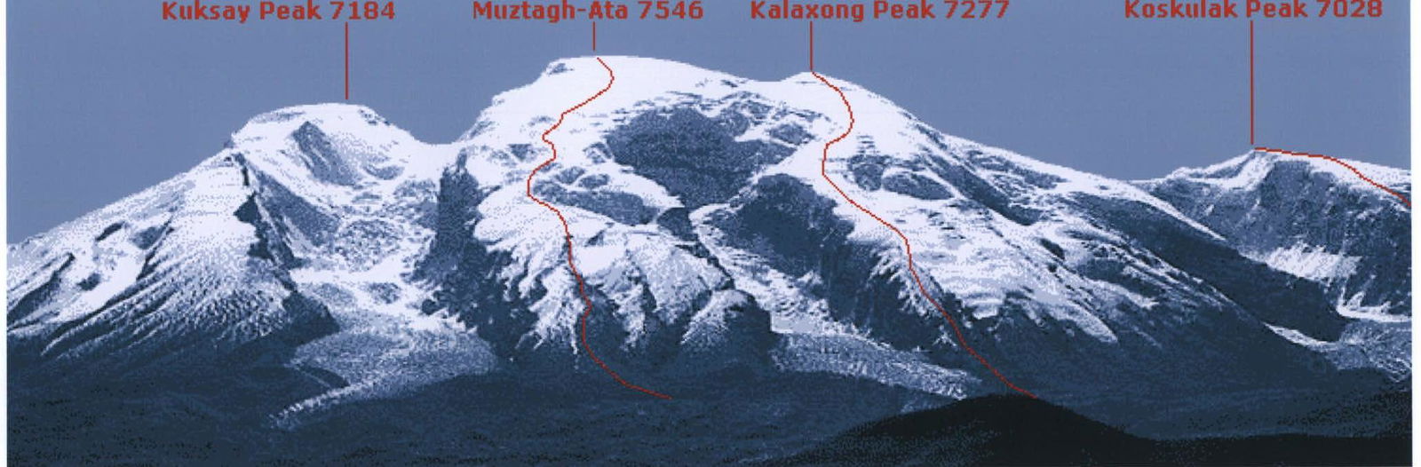
Photo #4 (A. Ershov), August 2004, from the Karakoram Highway, 3700 m.
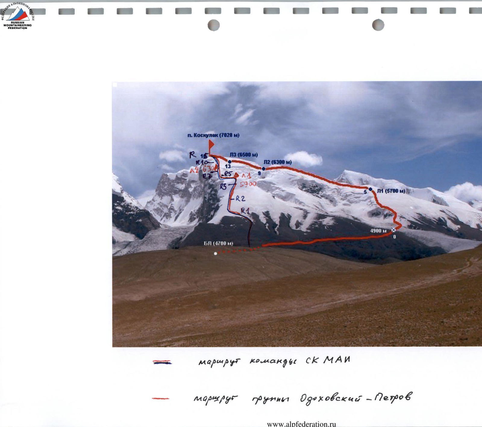
Ascent object map with route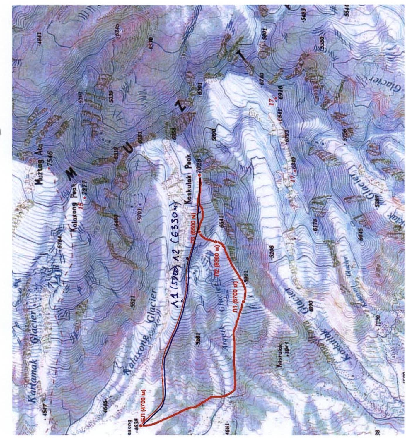
MAI Sports Club team route Odokhovsky-Petrov group route
Brief Overview of the Ascent Region
Peak Koskulak, 7028 m is located in China, in the Muztag Ata massif, between the peaks of Muztag Ata (7546 m) to the north and Peak 6849 m to the south.
The eastern edge of the Pamir Plateau is bordered by a chain of high mountain ranges. They rise like a huge wall above the oases of Kashgar and the Taklamakan Desert. This chain starts from the eastern edges of the Trans-Alai range and, turning southeast, turns into the King-Tau range with the highest mountain Chakragil 6670 m (some maps show the name Karabektortag). The Kashgar range is separated from the meridional part of the King-Tau range by the Gez River valley. The upper reaches of the Tashkurgan River separate the Kashgar range from the Tashkurgan and Chon-Kyr ranges to the east, which continue this mountain chain until it connects with the Western Kunlun.
The highest points of the Kashgar range – the peaks of Muztag Ata (7546 m) and Kongur Tag (7719 m) – lie at the intersection of the axial lines of many ranges. They are attributed to both the Eastern Pamir and the Western Kunlun. The total glaciation area of the range is 2258 km². There are dozens of glaciers on Kongur and Muztag Ata, with the largest reaching 15 km.
The foothills to the west and southwest are located at altitudes of 3800–4000 m, the slopes have rather gentle outlines, although they are quite steep. Glacier tongues are located at altitudes of around 4500 m. The valleys to the east are more deeply incised than to the west, and the rivers flow through canyons in some places.
On the northern slopes of the ranges, forests of fir, juniper, and Tien Shan spruce are preserved in some places.
The main population of the Kashgar mountains are Kyrgyz. To the east and northeast, the Muztag Ata massif is cut off by 2–3 km high rock-ice walls. To the west, the entire massif is cut through by a system of cirques with kilometer-high walls. Muztag Ata is a popular object for climbers, but Peak Koskulak had not been climbed before.
The journey from the city of Kashgar (1300 m), Xinjiang Uyghur Autonomous Region, China – 4–5 hours to Karakul Lake (3600 m). The road in the lake area is being improved, and delays are possible. There is a tourist base on the lake, with yurts for overnight stays.
Further along the highway for 20–23 km. From here, the base camp (BC) for the ascent of Koskulak can be reached by two routes:
- First – 2–3 km to the left before the pass, then 4–5 hours with a caravan of donkeys.
- Second – from the pass to the left by jeeps to the lake, from where it takes 1 hour to BC.
BC (4700 m) is on grass, with a stream nearby.
The approach to the start of the route along the NW slope from BC:
- Climbing scree slopes, which turn into snow-ice slopes at an altitude of 4800 m.
- Reaching the shoulder at an altitude of 5200 m.
- The path along scree and snow-ice slopes is the beginning of the route.
- The length of the approach from BC is 300 m.
Ascent Schedule and Weather Conditions

BC – Base Camp, C1 – Camp 1, C2 – Camp 2
Altitudes were determined by altimeters in hours, as well as by the JPS system.
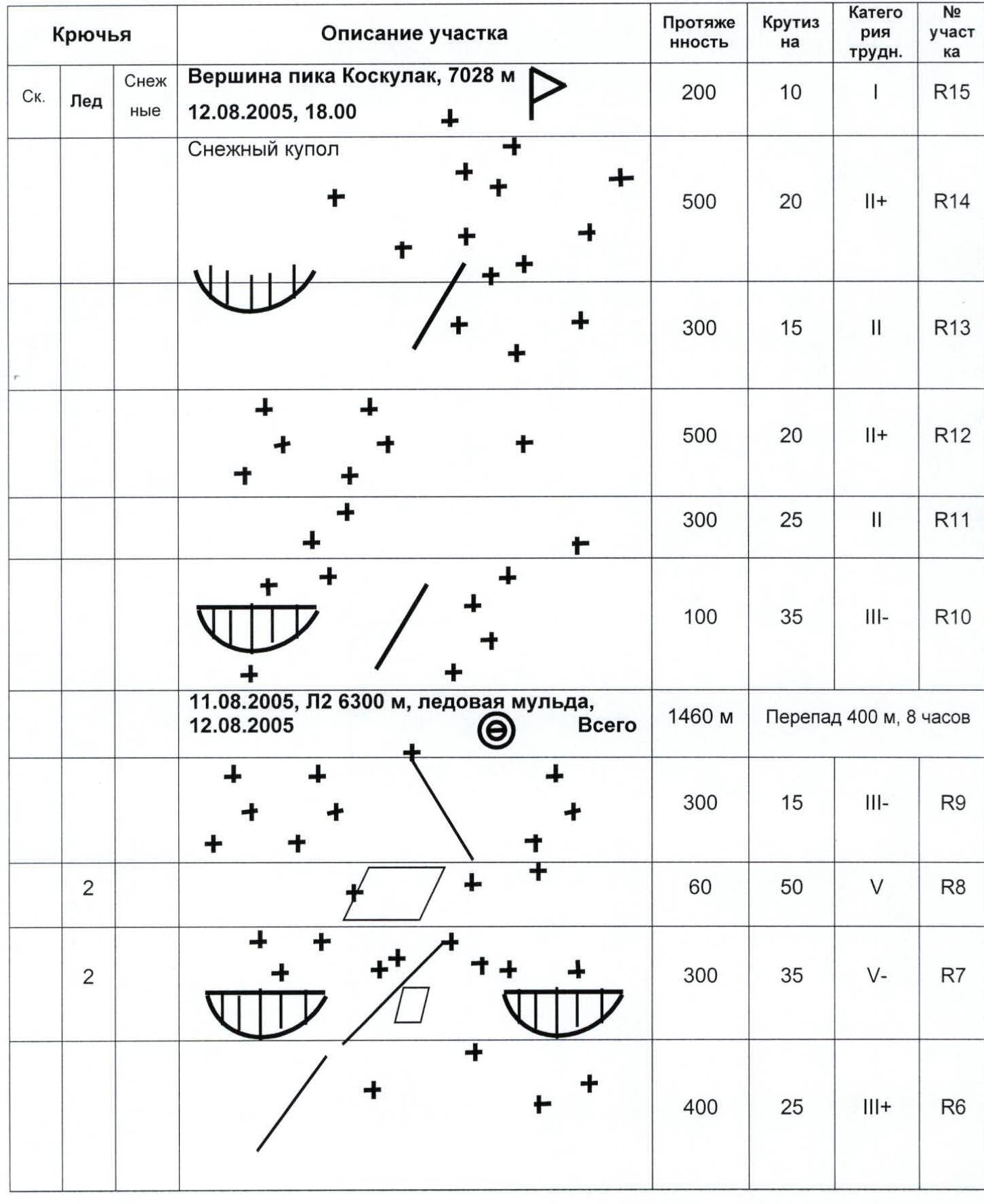
Route Diagram in UIAA Symbols
| Rock Pitons | Ice | Snow | Section Description | Length | Slope | Difficulty Category | Section # |
|---|---|---|---|---|---|---|---|
| Summit of Peak Koskulak, 7028 m | 200 m | 10° | 1 | R15 | |||
| August 12, 2005, 18:00 | |||||||
| Snow dome | 500 m | 20° | 2 | R14 | |||
| 300 m | 15° | 2 | R13 | ||||
| 500 m | 20° | 2 | R12 | ||||
| 300 m | 25° | 2 | R11 | ||||
| 100 m | 35° | 3 | R10 | ||||
| August 11, 2005, C2 6300 m, ice cirque, August 12, 2005 | |||||||
| Total | 1460 m | Elevation gain 400 m, 8 h | |||||
| 300 m | 15° | 3 | R9 | ||||
| 2 | 60 m | 50° | 5 | R8 | |||
| 2 | 300 m | 35° | 5 | R7 | |||
| 400 m | 25° | 3 | R6 |
Route Diagram in UIAA Symbols (continued)
| Length | Slope | Difficulty Category | Section # |
|---|---|---|---|
| 400 m | 10° | 2 | R5 |
| Total | Elevation gain 1200 m, 9 h | ||
| 400 m | 20° | 2 | R4 |
| 800 m | 25° | 2 | R3 |
| 500 m | 35° | 3 | R2 |
| 700 m | 25° | 2 | R1 |
| 300 m | 15° | 1 | R0 |
| 6100 m | 22° | 5A |
Additional table data (outside main table structure for layout reasons):
August 10, 2005, C1 5900 m on a snow shoulder Intermediate camp on the slope, 5450 m Shoulder 5200 m August 10, 2005 BC–C1 4800 snow slope – 5900 – C1 Base Camp 4700–4800 m, scree

History of the Ascent of Peak Koskulak, 7028 m
This year, several attempts were made by various groups of climbers to ascend Peak Koskulak, 7028 m. It is surprising that this had not been done before, as the peak is located in the popular Muztag Ata massif and is clearly visible from the Karakoram Highway.
The initiative of well-known researchers of this region, Andrei Ershov (St. Petersburg, "Ersh-travel") and Andrei Lebedev (Moscow, MAI), published on the Internet, attracted the attention of several groups. Initially, in June – early July, British climbers attempted to ascend the peak via the northwest ridge but were unsuccessful. They left large bamboo wands up to an altitude of 5800 m.
Several expeditions arrived from Russia. A group led by A. Novik, consisting of three people, attempted to climb the peak before our expedition. After heavy snowfall, the group launched a summit attempt on August 10, 2005, from 6200 m via the northwest ridge. They reached an altitude of approximately 6900 m by 21:00, according to their report, and then turned back.
The MAI Sports Club expedition also chose the route via the northwest ridge. Departing from 6300 m on August 12, 2005, the group of 7, led by M. Volkov, reached the summit by 18:00, making the first ascent. The participants used snow crampons provided by A. Novik's group. The descent to Camp 6300 m was in conditions of snowfall, blizzard, and poor visibility. Finding the tents was aided by the use of the JPS system.
The MAI Sports Club group, led by Mikhail Volkov, then climbed a technically complex route via the northern edge. A group from St. Petersburg, consisting of Gorbatenko and Shanalo, climbed a technically complex route via one of the edges of the northern wall.
An international expedition, led by Andrei Ershov, with around 25 participants, arrived in the area almost simultaneously with us. Groups from this expedition attempted to ascend via the southwest ridge but were only able to reach an altitude of 6500 m. Their route was later completed by the duo Odokhovsky-Petrov from our expedition.
Photo Illustrations of the Report (continued)
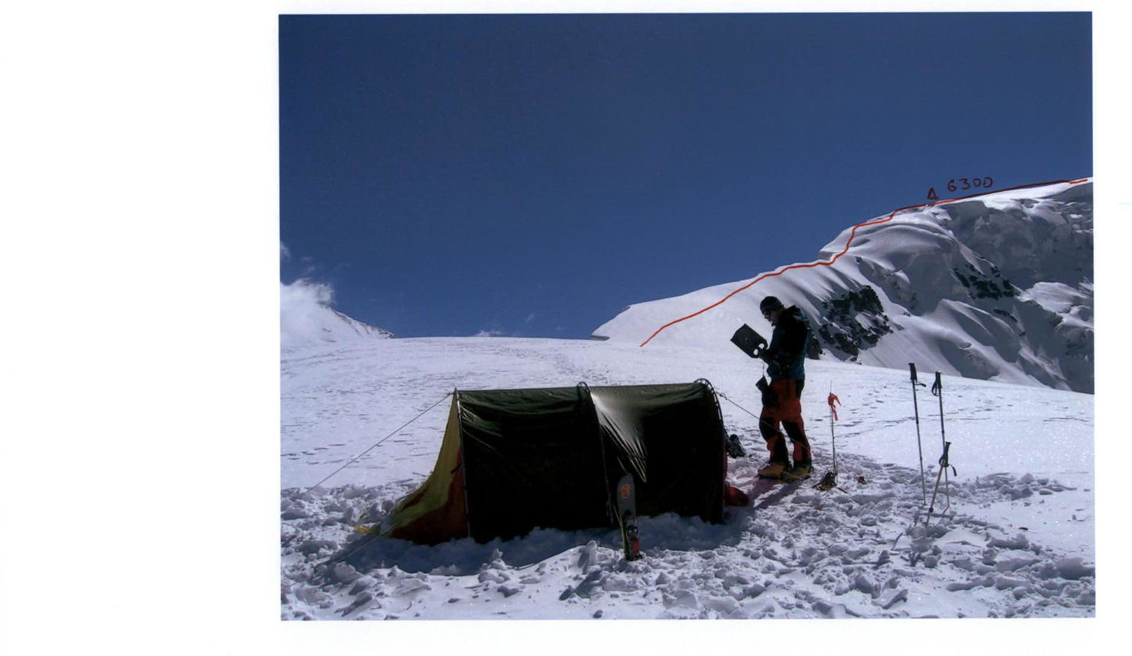
Camp 1 at 5900 m. The path to Camp 2 at 6300 m is shown.