
Russian Mountaineering Championship
High-altitude Class
2023
ASCENT REPORT
on the ascent to the peak of Voennykh Topografov, 6873 m, via the center of the Southwest wall
6B category of difficulty (approximately), first ascent by a combined team from Krasnoyarsk Krai and Novosibirsk Oblast. Period: 01.08.2023 – 07.08.2023
| 1. General Information | ||
|---|---|---|
| 1.1 | Full name, sports rank of the team leader | Parfyonov A.A. (Master of Sports) |
| 1.2 | Full names, sports ranks of the team participants | Mukhametzyanov R.N. (Master of Sports), Sukharev A.Yu. (Candidate Master of Sports) |
| 1.3 | Full name of the coach | Zakharov N.N. (Master of Sports of International Class), Balezin V.V. (Master of Sports of International Class) |
| 1.4 | Organization | Krasnoyarsk Krai Alpine Federation, Federation of Alpinism and Rock Climbing of Novosibirsk Oblast |
| 2. Characteristics of the Ascent Object | ||
| 2.1 | Region | Tian-Shan |
| 2.2 | Ridge | Meridionalny |
| 2.3 | Section number according to the 2013 classification table | 11.3 |
| 2.4 | Name and height of the peak | Voennykh Topografov, 6873 m |
| 2.5 | Geographic coordinates of the peak (latitude/longitude), GPS coordinates | N42.076948 E80.323826 |
| 3. Characteristics of the Route | ||
| 3.1 | Route name | Via the center of the Southwest wall, "Lost World" |
| 3.2 | Proposed category of difficulty | 6B |
| 3.3 | Degree of route exploration | First ascent |
| 3.4 | Relief characteristics of the route | Combined |
| 3.5 | Elevation gain of the route (data from altimeter or GPS) | 1923 m |
| 3.6 | Route length (in meters) | 3306 m |
| 3.6a | Route length from the bergschrund to the Western ridge | 2006 m |
| 3.6b | Length of the wall section | 1202 m |
| 3.7 | Technical elements of the route (total length of sections of varying difficulty with indication of relief characteristics (ice-snow, rock)) | II–III category of difficulty — 1960 m, IV category of difficulty — 435 m, V–VI category of difficulty — 911 m |
| 3.8 | Average steepness of the route, ° | 41° |
| 3.9 | Average steepness of the wall section, ° | 73.1° |
| 3.9a | Average steepness of the route from the bergschrund to the Western ridge | 60° |
| 3.10 | Descent from the peak | Along the Western ridge to the Chon-Toren pass |
| 3.11 | Additional characteristics of the route | Safe from rockfall. Sufficiently monolithic. |
| 4. Characteristics of the Team's Actions | ||
| 4.1 | Travel time (team's travel hours, indicated in hours and days) | 73.6 hours, 6.5 days |
| 4.2 | Overnight stays | 5 on a ledge on the wall, 1 on the ridge, in a hollow before the Western peak |
| 4.3 | Route processing time | 0 hours, 0 days |
| 4.4 | Departure on the route | 6:00 01.08.2023 |
| 4.5 | Arrival at the peak | 10:20 07.08.2023 |
| 4.6 | Return to ABC on the Chon-Toren pass | 16:00 08.08.2022 |
| 5. Characteristics of Weather Conditions | ||
| 5.1 | Temperature, °C | –15...+5 °C |
| 5.2 | Wind speed, m/s | Up to 15 m/s |
| 5.3 | Precipitation | Wet snow, snow grains (on the ridge) |
| 5.4 | Visibility, m | Generally good, on the ridge on the day of ascent not more than 40 m |
| 6. Person Responsible for the Report | ||
| 6.1 | Full name, e-mail | Parfyonov A.A. patriodemoerte@mail.ru |
II. Ascent Description
- Characteristics of the Ascent Object.
1.1. General photo of the peak
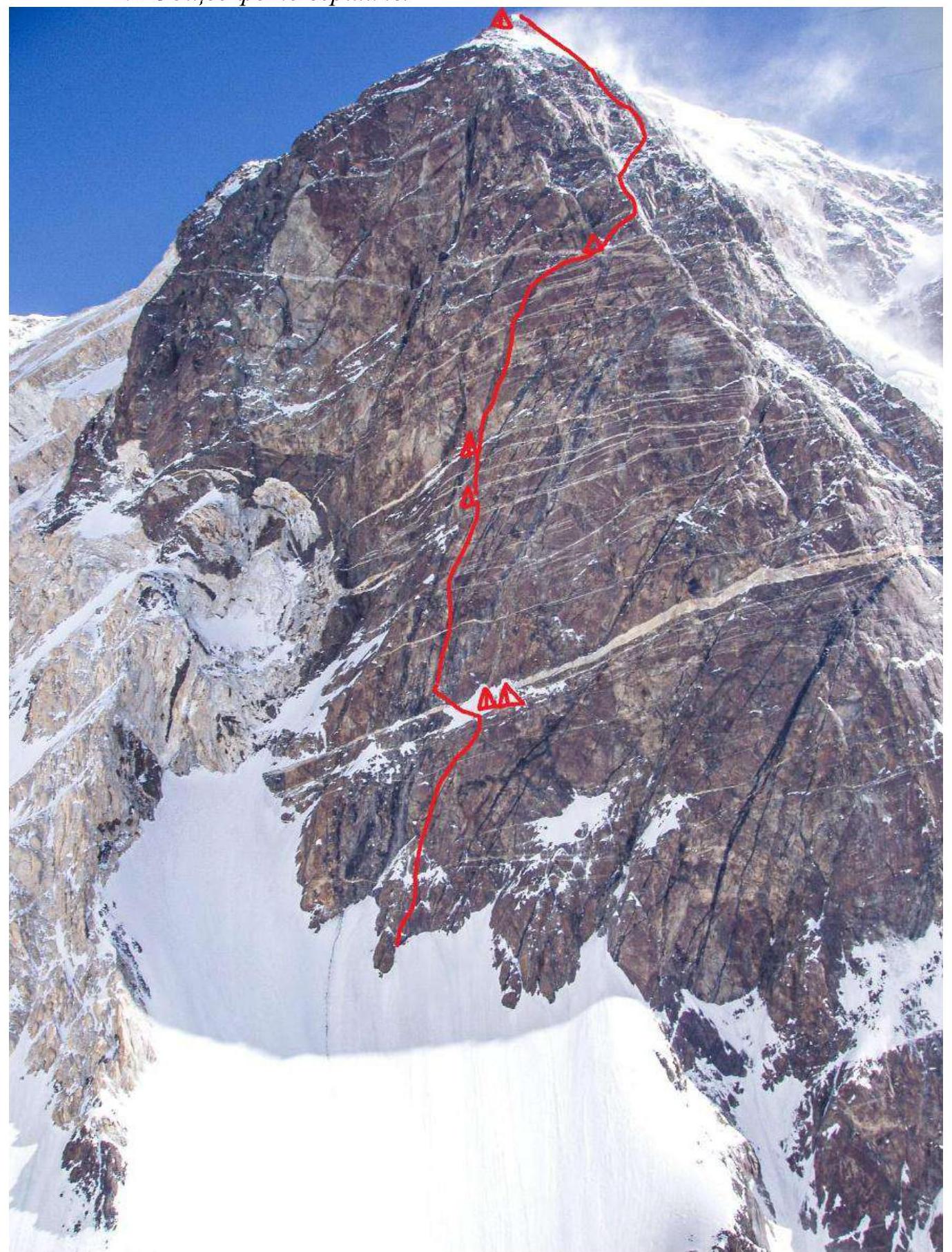
Route taken by the team.
1.2. Photo of the route profile
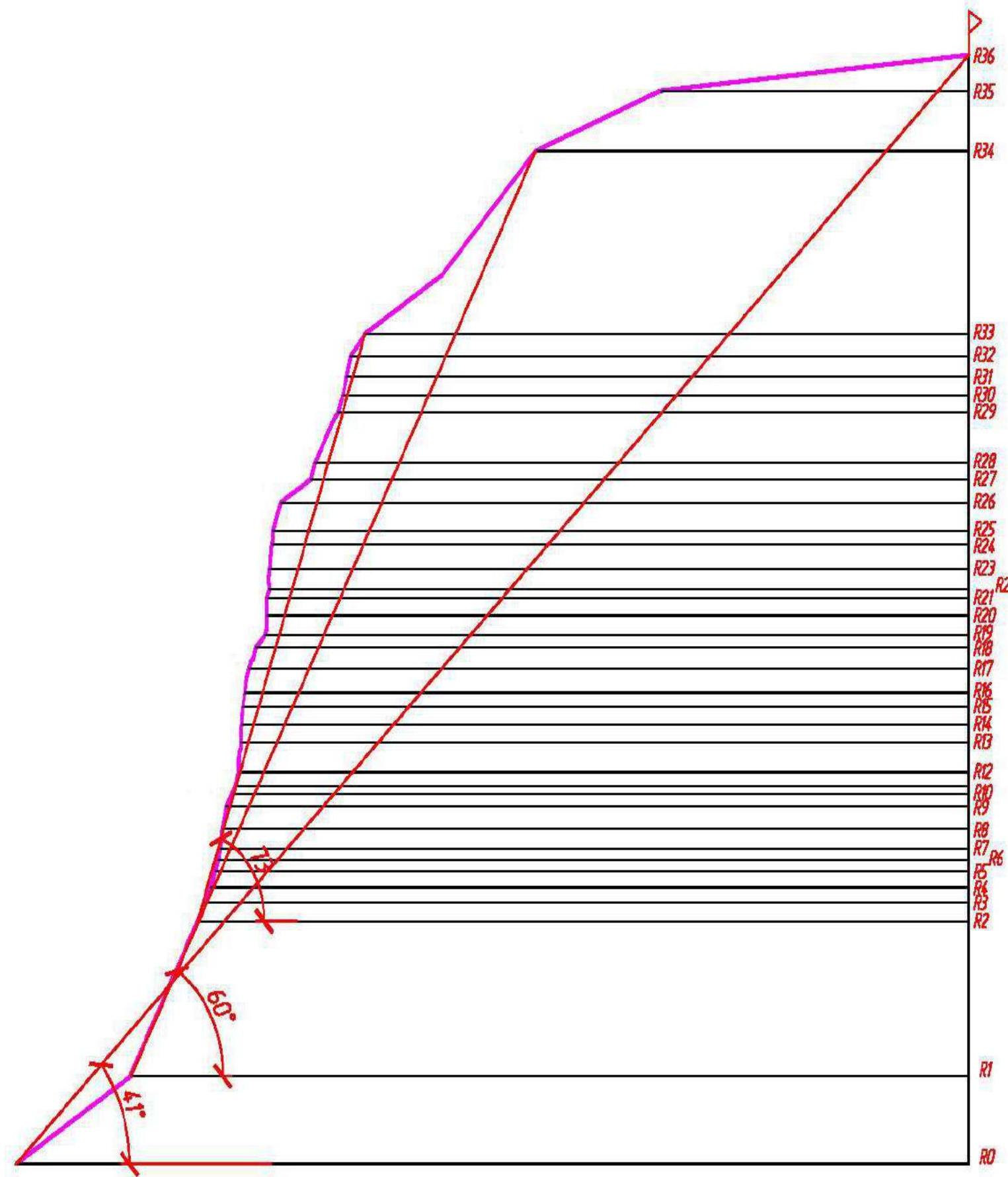
1.3. Drawn profile of the route
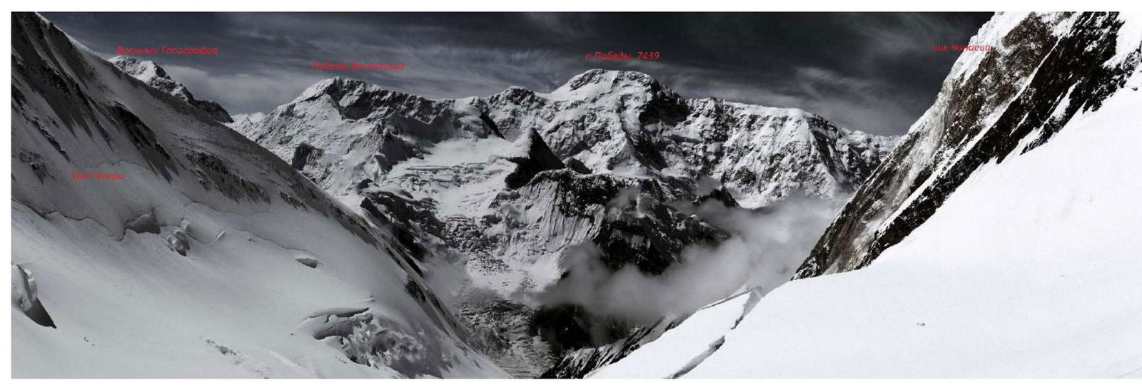
1.4. Photopanorama of the area
Panorama from the peak of Khan-Tengri from camp 3
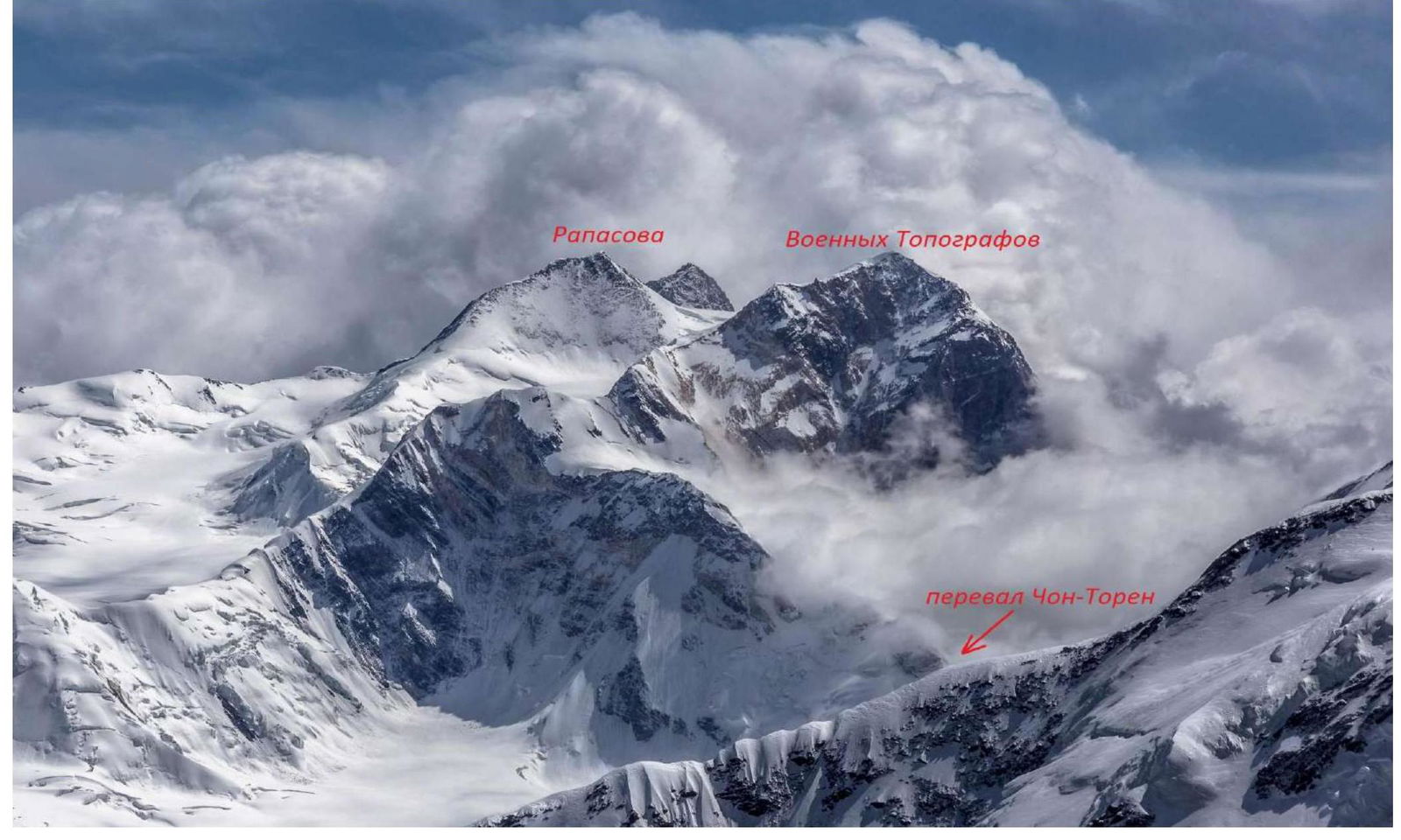
Panorama of the Voennykh Topografov – Rapatov massif from the slopes of peak Pobeda (Medzmariashvili route)
1.5. Map of the area
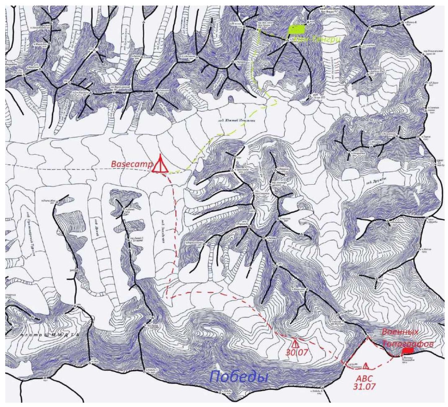
Map-scheme of the area. Dashed lines indicate team movements during acclimatization exits and approach under the wall. Green line — acclimatization exit to Khan-Tengri, red line — route of approach under the wall of Voennykh Topografov and return to base camp.
- Characteristics of the Route
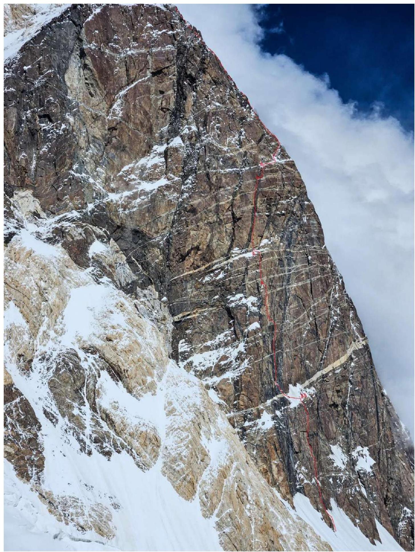
2.1. Technical photograph of the route
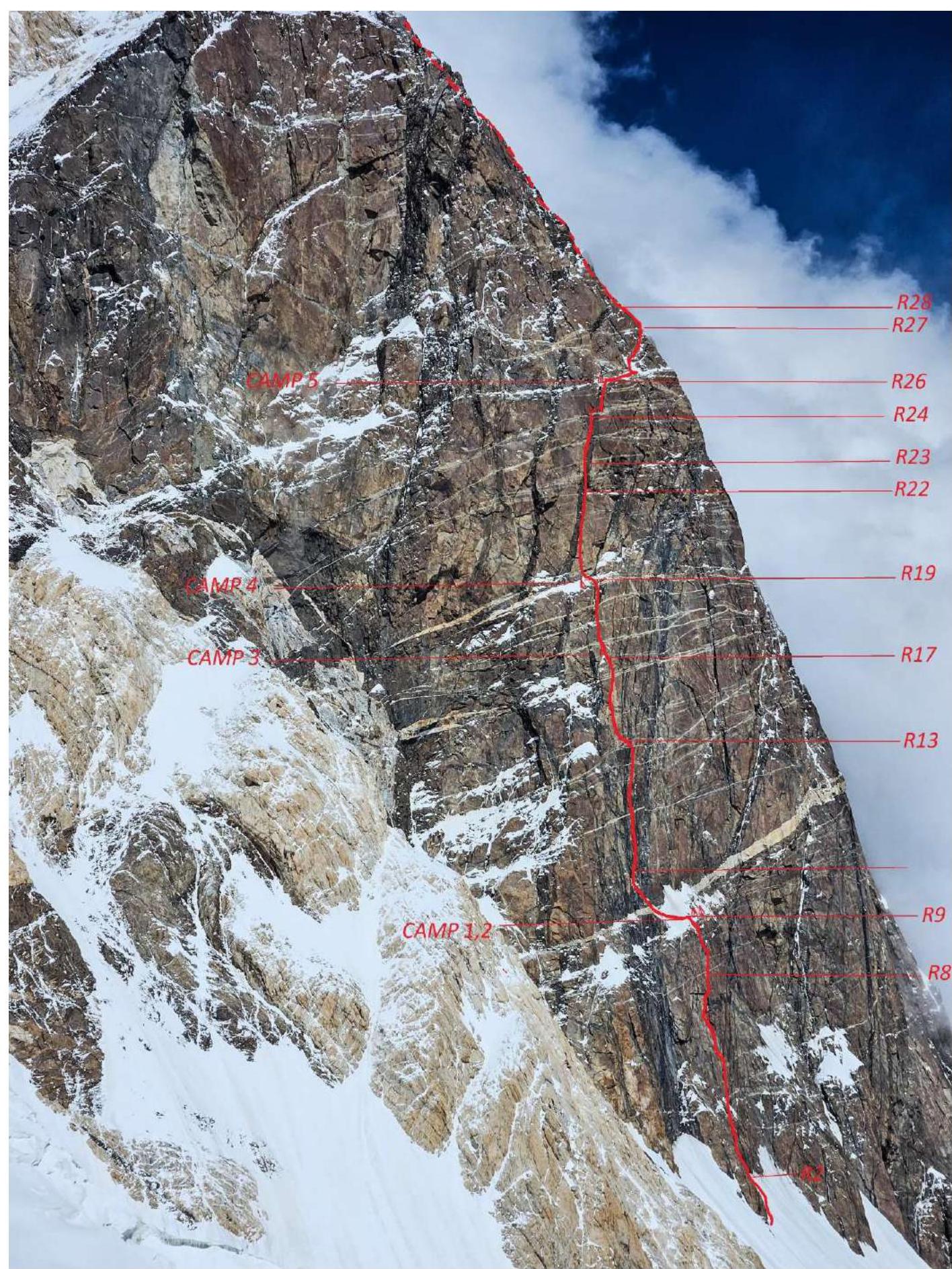
2.2. Route diagram in UIAA symbols:
| Pitch | Friends | Nuts/hex | Skyhooks | Ice screws | Bolts/removers | Length, m | UIAA | Steepness, ° |
|---|---|---|---|---|---|---|---|---|
| R0 | 300 | I | 30 | |||||
| R1 | 20 | 300 | IV | 55–60 | ||||
| R2 | 2 | 3 | 35 | IV–V | 60 | |||
| R3 | 2 | 3 | 30 | IV | 60 | |||
| R4 | 2 | 5 | 30 | V–VI | 65–70 | |||
| R5 | 5 | 5/4 | 30 | V–VI, A1 | 65–70 | |||
| R6 | 4 | 5/4 | 23 | VI, A2 | 75–80 | |||
| R7 | 5 | 3 | 8 | 0/1 | 34 | VI, A1–A4 | 75–110 | |
| R8 | 2 | 2 | 2 | 40 | V–VI | 70–75 | ||
| R9 | 3 | 25 | V | 60–70 | ||||
| R10 | 15 | IV | 60–70 | |||||
| R11 | 5 | 25 | V–VI, A2 | 60–75 | ||||
| R12 | 7 | 7/5 | 56 | V–VI, A2 | 60–90 | |||
| R13 | 4/10 | 12 | 1/1 | 30 | A3 | 85–90 | ||
| R14 | 5 | 18 | 2/2 | 30 | A1–A3 | 80–85 | ||
| R15 | 5/7 | 5 | 1/0 | 25 | A2–A3 | 75–80 | ||
| R16 | 7 | 4 | 10 | 0/1 | 42 | VI, A1–A3 | 70–80 | |
| R17 | 3 | 6 | 40 | V+ | 70–75 | |||
| R18 | 2 | 1 | 3 | 30 | III–IV | 45 | ||
| R19 | 7 | 7/7 | 1/0 | 45 | IV–VI, A1–A2 | 65–95 | ||
| R20 | 5 | 5/5 | 30 | A2 | 90–95 | |||
| R21 | 5 | 5 | 15 | V+, A0 | 65 | |||
| R22 | 5 | 5/10 | 35 | VI, A1–A2 | 90–95 | |||
| R23 | 42 | A0–A3 | 80–85 | |||||
| R24 | 4 | 5 | 12 | 3/2 | 37 | V, A1–A2 | 75–90 | |
| R25 | 5 | 5 | 52 | V–VI | 65–75 | |||
| R26 | 1 | 5 | 80 | I–III | 10–30 | |||
| R27 | 4 | 3 | 30 | V+ | 70–75 | |||
| R28 | 4 | 4 | 100 | III–IV | 30–60 | |||
| R29 | 4 | 4 | 30 | IV | 70 | |||
| R30 | 5 | 5 | 35 | IV–V | 65–75 | |||
| R31 | 3 | 4 | 35 | V | 75 | |||
| R32 | 2 | 50 | IV | 50 | ||||
| R33 | 500 | I–II | 30–45 | |||||
| R34 | 500 | I–II | 10–20 | |||||
| R35 | 700 | I–II | 10–20 |
3. Characteristics of the Team's Actions
3.1. Brief description of the route passage
Comments
Sign in to leave a comment