
Report
On the ascent via the classic route through the SE ridge to Jungfrau peak (4158 m), 2B–3A cat. sl. Jungfrau region. Bernese Alps, Switzerland.
Moscow, 2013
Climbing Passport
- Alps. Bernese Alps. Switzerland. Section according to KMGV 2013 — 10.3.
- Peak Jungfrau (German: Jungfrau). Height 4158 m. Via SE ridge. Route name: classic route via SE ridge from Rottal Sattel.
- Proposed category: 2B–3A cat. sl. First ascent by J. Rudolf, H. Meyer, J. Bortis, A. Volker on August 3, 1811.
- Route type: combined.
- Height difference: 760 m (by altimeter)
Route length: 1650 m, average slope: entire route — 43°
- Number of pitons left on the route: 0, used:
- Team's total climbing time: 10 hours, descent 5 hours
- Team leader: Ivan Trofimovich Dusharin — Master of Sports of International Class
Team members:
- Anatoly Govorov — badge holder
- Natalia Govorov — badge holder
- +3 groups with leaders (9 people)
- Coach: I.T. Dusharin
- Departure from Base Camp: hour, day, month, year
Route started: 3:00 AM, July 23, 2013. Reached the summit: 10:00 AM, July 23, 2013. Returned to Base Camp: 3:00 PM, July 23, 2013. Descent from the summit: via the ascent route to Rottal, then directly to Aletsch glacier.
-
Organization:
-
Report responsible: A.V. Yurkin. Email: s2_aleks@mail.ru
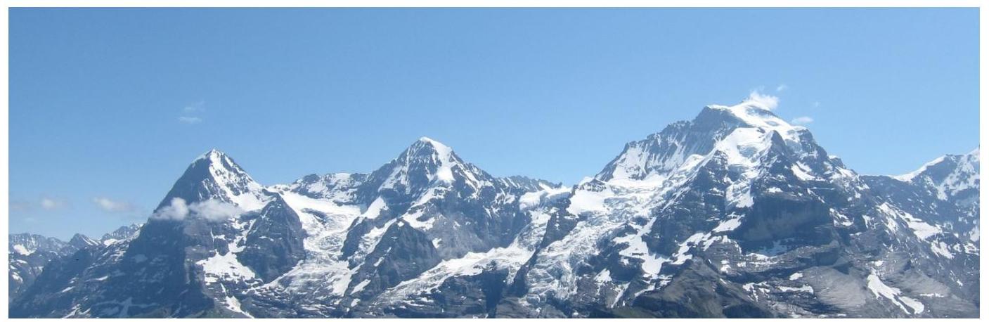
General photo of the summit.
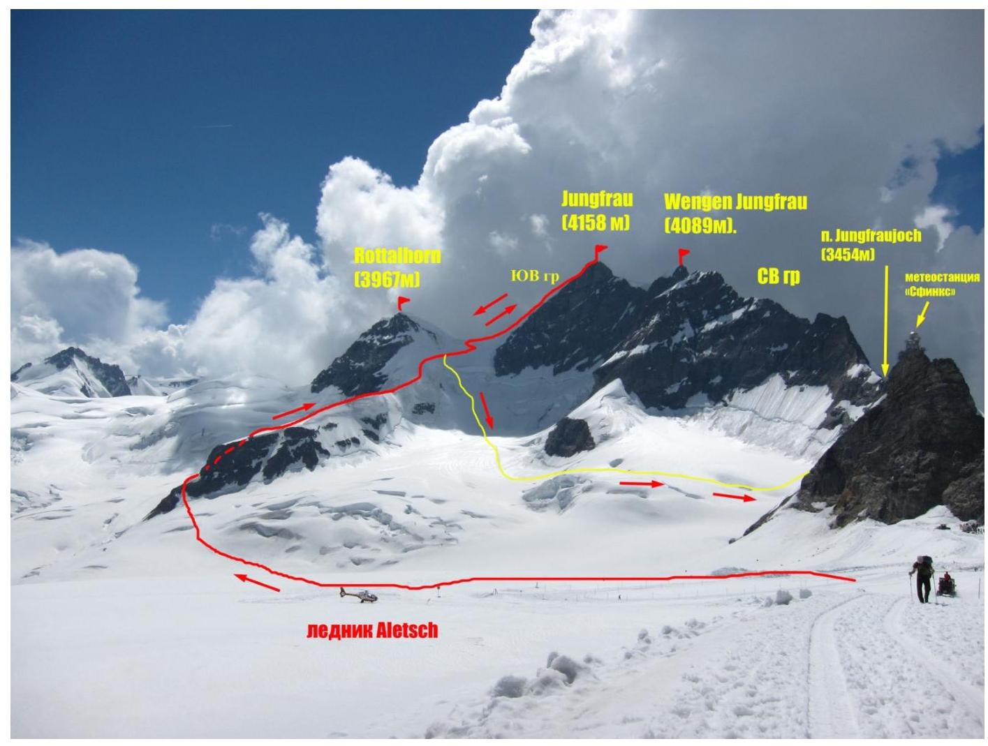
Photo of Jungfrau summit from Aletsch glacier between Jungfraujoch pass and Mönch peak. Taken on July 22, 2013.
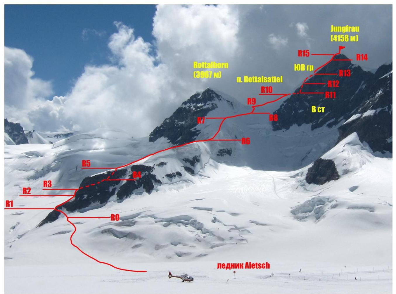
Photo of the route profile
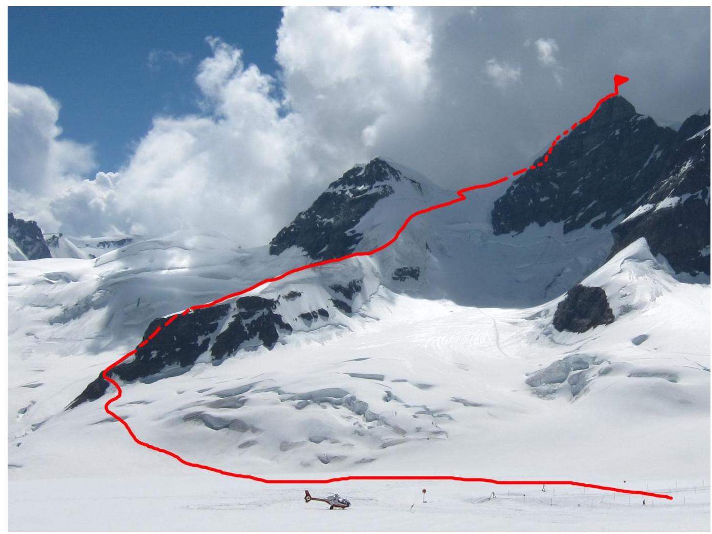
Photo of the route profile. Taken from Aletsch glacier on July 22, 2013.
Overview of Jungfrau region
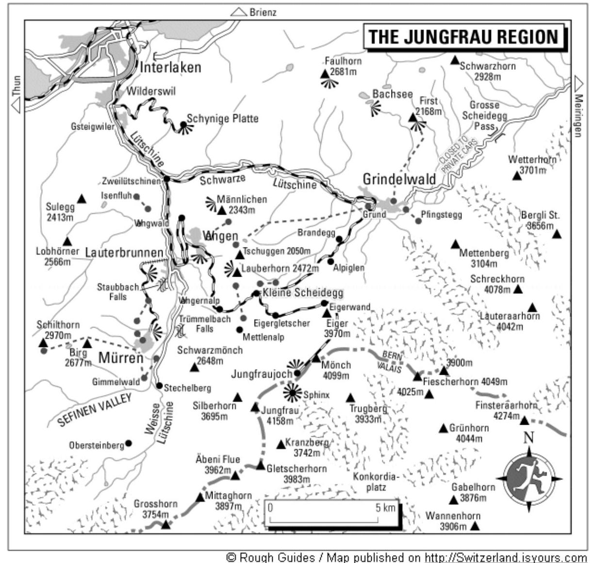
© Rough Guides / Map published on http://Switzerland.isyours.com ↗
Map scheme of Jungfrau region. Scheme taken from Switzerland.isyours.com
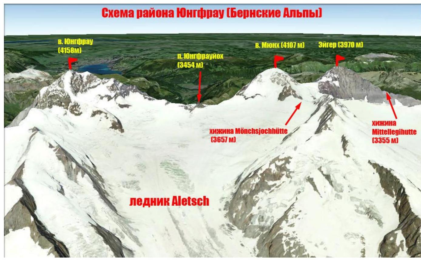
Jungfrau region scheme (German: Jungfrau) — one of the most famous mountain peaks in Switzerland. Its height is 4158 m above sea level. It is the third highest peak in the Bernese Alps, forming a notable trio with Eiger (German: Eiger) and Mönch (German: Mönch) peaks.
On December 13, 2001, Jungfrau peak was included in the UNESCO World Heritage List as part of Jungfrau-Aletsch-Bietschhorn, becoming the first natural site in the Alps to be listed.
The name "Jungfrau" (Russian: "maiden", "virgin") is attributed to the nuns from Interlaken, whose monastery was located near the foot of the mountain. The name later transferred to the mountain itself.
Geographic coordinates of the summit: 46°32′12.24″ N 7°57′45.20″ E. The Jungfrau peak forms the border between the cantons of Bern and Valais. The mountain is quite unique. To the north and northwest, its snowy peaks, including Wengen-Jungfrau, Schneehorn, both Silberhorns, and Schwarzmönch, are visible. To the west, it appears largely snowless and unremarkable, rising 3250 m above the Lauterbrunnen valley (the longest slope in the Alps after Mont Blanc). Its southern part rises above the hidden glaciers of Rottals, and the eastern part — above the snow-covered saddle of Jungfraujoch pass.
Between 1896 and 1912, the Jungfrau Railway was built here. The construction was led by Swiss engineer Adolf Guyer-Zeller. Plans to extend the railway to the very summit of Jungfrau remained unrealized; it only reaches the Jungfraujoch saddle. The route goes from Kleine Scheidegg station to Eigergletscher station through open terrain, then through a tunnel upwards with panoramic views through windows:
- from Eigerwand station to alpine landscapes,
- from Eismeer station to eternal ice and rocks.
The final station, "Top of Europe," is the highest railway station in Europe. In the rocks and glacier covering the Jungfraujoch saddle, galleries have been carved out. From the observatory and meteorological station "Sphinx," an alpine panorama of 360° unfolds, with views of the longest glacier in Europe — Aletsch (24 km) and the Thun Lake valley.
Our team's ascent to Jungfrau peak began from Mönchsjochhütte hut (3627 m), which served as a base for the entire climbing cycle in the region. The hut is located on the Aletsch glacier under the slopes of Mönch peak (4107 m).
The approach to the hut was as follows:
- By train to Jungfraujoch station on the eponymous pass (3454 m)
- Then on foot along a well-trodden path to the hut (1 hour)
The ascent route is a classic path to the summit. It was first traversed by J. Rudolf, H. Meyer, J. Bortis, and A. Volker in 1811. According to the Swiss classification, it has a difficulty category of ZS– (Ziemlich Schwierig), corresponding to the French AD– (Assez Difficile).
Technical photography of the route
| Section N | Length, m | Slope, ° | Terrain type | Difficulty category | Number of pitons |
|---|---|---|---|---|---|
| R0–R1 | 30 | 45 | Snow-ice | II | |
| R1–R2 | 50 | 35 | Rocks-snow | II | |
| R2–R3 | 20 | 60 | Rocks | III | |
| R3–R4 | 150 | 45 | Rocks | II | |
| R4–R5 | 100 | 50 | Snow-ice | II | |
| R5–R6 | 300 | 30 | Snow | I | |
| R6–R7 | 200 | 40 | Snow | II | |
| R7–R8 | 200 | 30 | Snow | II | |
| R8–R9 | 50 | 50 | Snow-ice | III | |
| R9–R10 | 100 | 45 | Snow-ice | III | |
| R10–R11 | 50 | 45 | Snow-ice | III | |
| R11–R12 | 50 | 50 | Snow-ice | III | |
| R12–R13 | 50 | 50 | Snow-ice-rocks | III | |
| R13–R14 | 200 | 40 | Snow-ice | II | |
| R14–R15 | 50 | 35 | Rocks-ice | II | |
| R15–R16 | 50 | 20 | Rocks-ice | II |
Brief description of the route passage by sections. Approach: from Mönchsjochhütte hut, move down the glacier to Jungfraujoch station (30 minutes). 100–200 m before the station, turn left, bypassing the amusement park. Immediately after it, exit onto the glacier. Attention! Hidden crevasses! Then move along the glacier, first down, then up towards the beginning of the East ridge of Rottalhorn peak (40 minutes). During the season, a trail is trodden here, and numerous groups follow this route. Reach the beginning of the ridge (landmark — a large hydrometeorological device installed on the ridge), with a small bergschrund before the ascent.
R0–R1 — cross the bergschrund via a snow bridge and exit left onto rocks near a water collection point. Belay via ice axes. 30 m, 45°, II. R1–R2 — ascend the rocky ridge to a small wall. Belay via rock formations. 50 m, 35°, II. R2–R3 — up the wall via a series of ledges to a stance on bolts. 20 m, 60°, III. R3–R4 — left and up via ledges to the snow section of the ridge. Belay via rock formations. 150 m, 45°, II. R4–R5 — initially up, then right to avoid crevasses. Reach the top of the ridge. Belay via ice axes. 100 m, 45°, II
R5–R6 — ascend the simple ridge upwards. 300 m, 30°, I R6–R7 — climb a small ascent to the base of Rottalhorn peak's wall. 200 m, 40°, II
R7–R8 — bypass Rottalhorn peak on the right, ascend to Rottalsattel saddle. 200 m, 35°, II
R8–R9 — cross the bergschrund under the saddle via a snow bridge and then up a steep snow-ice wall to the saddle. Belay via ice axes. 50 m, 50°, III
R9–R10 — along the sharp ridge of the col, up and right to the beginning of Jungfrau's SE ridge. 100 m, 45°, III
R10–R11 — traverse left to the start of the rocky ridge. Belay via metal pins. 50 m, 45°, III
R11–R12 — ascend the steep snow-ice ridge. 50 m, 50°, III R12–R13 — move along the ridge 50 m, 50°, III R13–R14 — move along the snowy ridge to the rocky ascent before the summit. 200 m, 40°, II
R14–R15 — ascend snow-covered rocks to the pre-summit ridge 50 m, 35°, II
R15–R16 — along the rocky ridge to the summit. On the summit, a snow-ice cap. Attention — cornices! 50 m, 20°, II
Descent follows the ascent route to Rottalhorn slope, then:
- along the ascent route
- or, if snow-ice conditions permit (crevasses), directly down into Jungfrau cirque, exiting onto Jungfraujoch pass to the train station.
The route is logical and safe. It is interesting for training ascents as it includes practically all types of terrain.
At key points on the route (SE ridge), insurance anchors (metal pins 1 m high with a shackle at the top) are installed at stations every 40–50 m.
In bad weather with poor visibility, orientation difficulties may arise in the area of the snowy plateau under Jungfrau.
Photo illustration of the report.
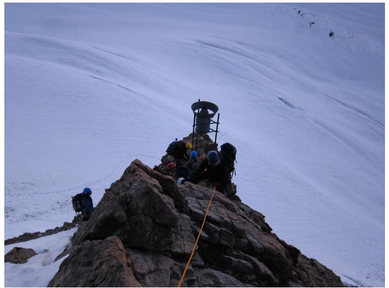
Photo 1. Section R1–R2. Exit to the ridge from the precipitation gauge
Photo 2. Passage of rocky section R2–R3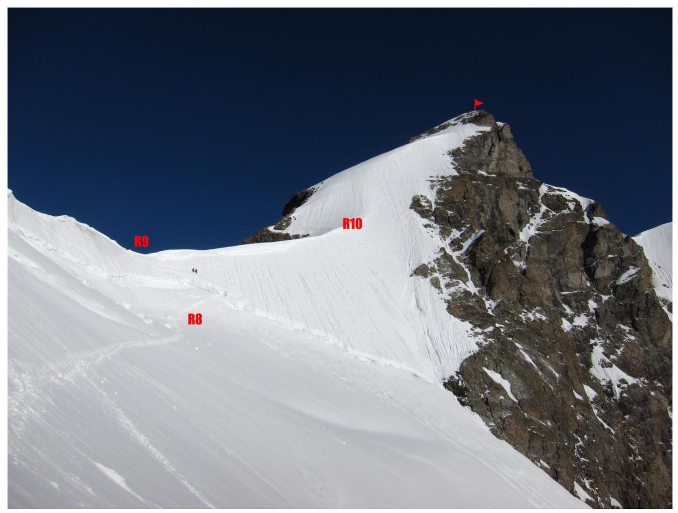
Photo 3. Section R7–R10. Under Rottalsattel pass
Photo 4. Section R10–R13. Photo from Rottalsattel pass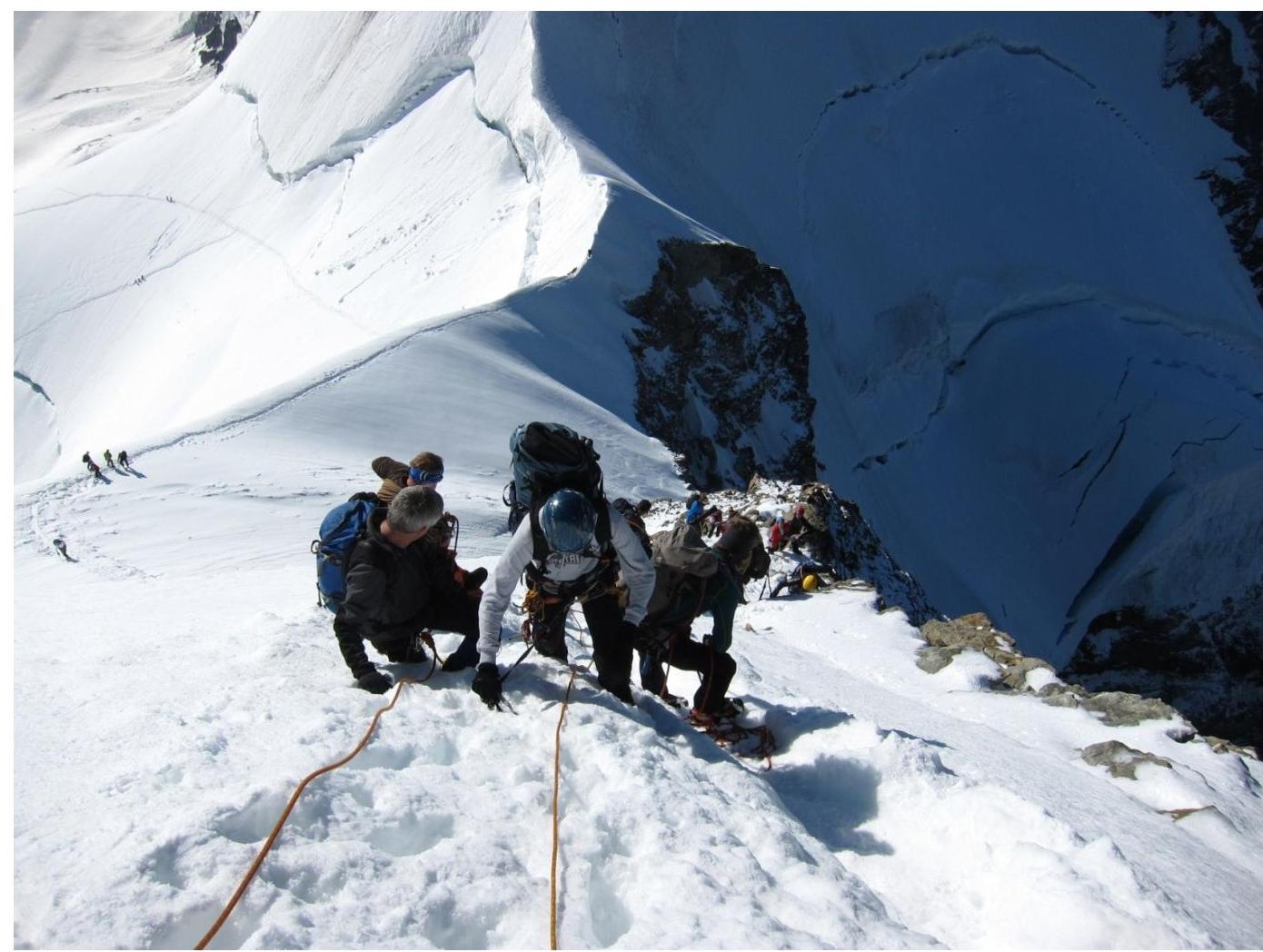
Photo 5. Section R10–R12. Ascent along the rocky-snowy ridge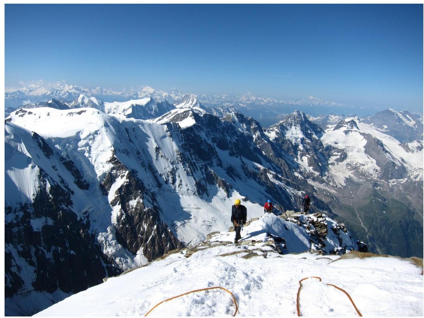
Photo 6. Pre-summit ridge R14–R15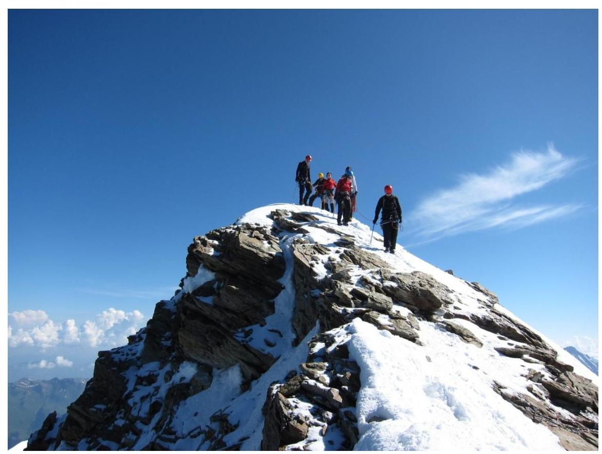
Photo 7. Groups on the summit, starting descent.
Comments
Sign in to leave a comment