Ascent Passport
- France. Savoy Alps, Chamonix area. Section №10.3 (according to KGBM 2013)
- Summit Aiguille du Midi (3842 m). Cosmic Ridge (first ascent G. Finch, M. Finch, 1911)
- Presumably — VI cat. diff.
- Route type: combined
- Height difference: 300 m
Route length: 820 m
Section lengths:
- V cat. diff. — m
- VI cat. diff. — m
Average steepness:
- main part of the route — 60°
- entire route — 30°
- Equipment used on the route:
set of friends, including bolted ones —
- Team's moving time: 6 hours (excluding descent)
- Leader: Vershinin V.V. 2 years
Participants: Sviatitskiy A. 2nd class; Prilepskaya N. MS
- Coach: Yurkin A.V.
- Departure for the route from the upper cable car station: "10:30", "26", "06", "2014"
Summit reached:
- "17-00"
- "26"
- "06"
- "2014"
Return to overnight stay:
- "19-00"
- "26"
- "06"
- "2014"
Descent from the summit: via cable car to Chamonix village.
1. General information about the ascent area
The summit Aiguille du Midi (3842 m), on which the ascent took place, is located in the Chamonix valley area. This valley is territorially situated within the Savoy Alps in southern France. Chamonix is known for its developed mountain infrastructure, glorious alpine traditions, and history.
The highest point in the Chamonix area and the Savoy Alps is Mont Blanc (4808 m), which is the highest peak in the Alps.
The ascent to Aiguille du Midi took place within the framework of the training camp of the CSKA named after Demchenko (Moscow) in June-July 2014.
The base camp of the training camp was located in the Montroc campsite. The village is the highest settlement in the Chamonix valley after Le Tour (which is slightly higher but is located off the main road to the pass from Chamonix to the neighboring valley). The elevation is 1300–1400 m above sea level.
Most routes interesting for alpinism are located in the Mont Blanc massif. Since the height of the peaks in the area is 3500–4000 m, almost all forms of relief are present:
- rocks
- ice
- snow
There are many combined routes. The area offers a wide variety of rock, ice-snow, and combined routes from 1B to 6A cat. diff.
The immediate exit to the route was made from the upper cable car station.
The route to the summit Aiguille du Midi via the Cosmic Ridge was first ascended by G. Finch and M. Finch on August 2, 1911.
Coordinates of the main points on the route:
- Upper cable car station (summit Aiguille du Midi) WGS 84: 45.87892°C 6.88757° E
- Beginning of the ridge (Cosmic hut) WGS 84: 45.87297°C 6.88555° E
2. Approach to the route
The vast majority of ascents to Aiguille du Midi from the south are made as follows:
- Take the cable car to the uppermost station.
- Then follow a narrow ridge to descend to a plateau and move southwest towards the chosen route.
- To approach the start of the Cosmic Ridge route, move along the rock massif to the Abri Simond hut (approximately 30 minutes).
- The ridge begins to the right of the hut when viewed from the plateau.
3. Route profile
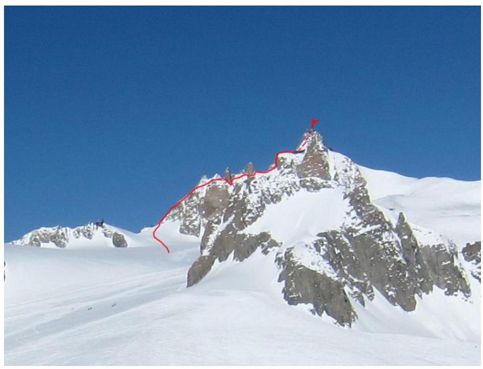
Photo of the route profile. Taken from the foot of Dent du Géant. July 20, 2014.
4. Description of the route passage by sections
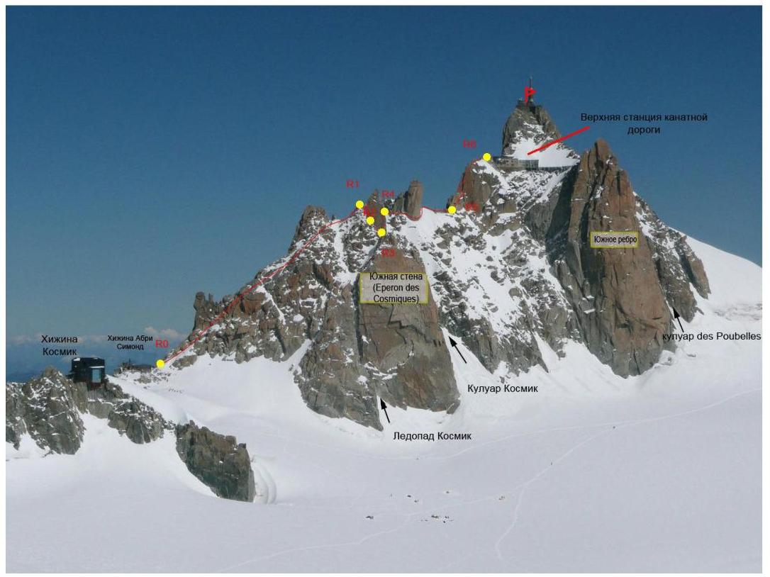
General view with the route line
R0–R1 — Ascent along the southern side of the ridge (alternating and simultaneous belay on protrusions) (400 m, II, 30°)
R1–R2 — Abseil 15 m II
R2–R3 — Abseil 15 m II
R3–R4 — Ascent to the ridge (camalots, закладки) (30 m, III, 60°)
R4–R5 — Movement along the ridge followed by an exit to rocks (camalots, закладки) (240 m, II, 10°)
R5–R6 — Ascent along rocks followed by an exit to the summit (camalots, закладки) (120 m, IV, 60°)
5. Route recommendations
The route along the Cosmic Ridge to the summit Aiguille du Midi is logical and safe. The approach is made across a closed glacier (Attention, crevasses!). It is recommended to bring:
- ice screws
- equipment for extracting from ice crevasses.
After the second abseil, there is a section where a small steep snowy slope needs to be traversed, which can be slushy and quite slippery.
The route is very popular, and numerous commercial groups may cause problems.
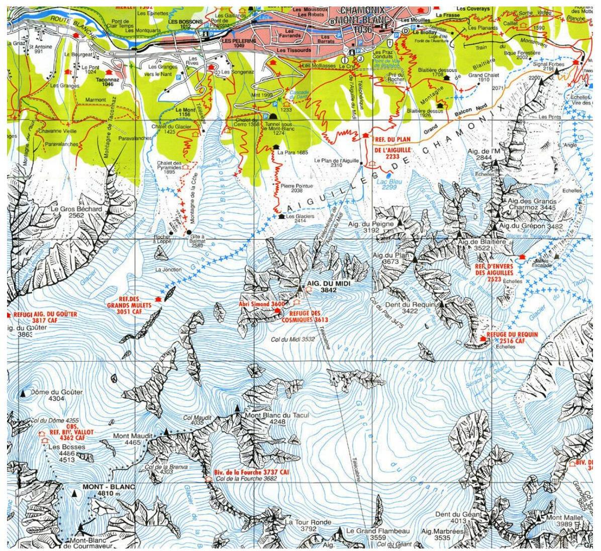
Topographic map of the Mont Blanc area.


