
Report
On the ascent of the CSKA team named after Demchenko to the summit of Ciarforon (Mont Ciarforon) 3640 m via the NW ridge, category 3B Graian Alps, Valle d'Aosta region, Gran Paradiso National Park, Italy
Team leader: M.V. Bogdanov Senior coach: E.V. Kuznetsova
Climbing Report
- Graian Alps (Italy). Gran Paradiso area. № 10.3 (according to KGVB 2011).
- Mt. Ciarforon 3640 m via NW ridge (first ascent in 1894 by D. Escoffier, O. De Falkner).
- Proposed category: 3B
- Route type: combined
- Height difference: 690 m Route length: 1400 m. Average slope: main part of the route – 55°; entire route – 35°
- Number of " закладок" (protection gear) used on the route: 1 set
- Climbing hours: 10 hours (excluding descent)
- Team leader: Bogdanov M.V., 1st sports category. Team members: Stepanenko E., 2nd sports category, Banasyukevich D., 3rd sports category, Belova T., 3rd sports category, Galkina N., 3rd sports category, Okhmanovich D., 3rd sports category, Petrova V., 3rd sports category, Petrova T., 3rd sports category.
- Coach: Kuznetsova E.V.
- Departure from Base Camp: 05:15, June 30, 2012. Route started: 07:00, June 30, 2012. Summit reached: 17:00, June 30, 2012. Return to Base Camp: 23:00, June 30, 2012. Descent from the summit: via NE ridge, category 2A, to Vittorio Emanuele II hut
- Organization: CSKA training camp named after Demchenko (Moscow)
- Responsible for the report: Bogdanov M.V., Yurkin A.V. Email: lis_fox@pisem.net
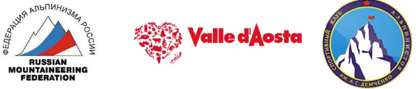
General photo of the summit.
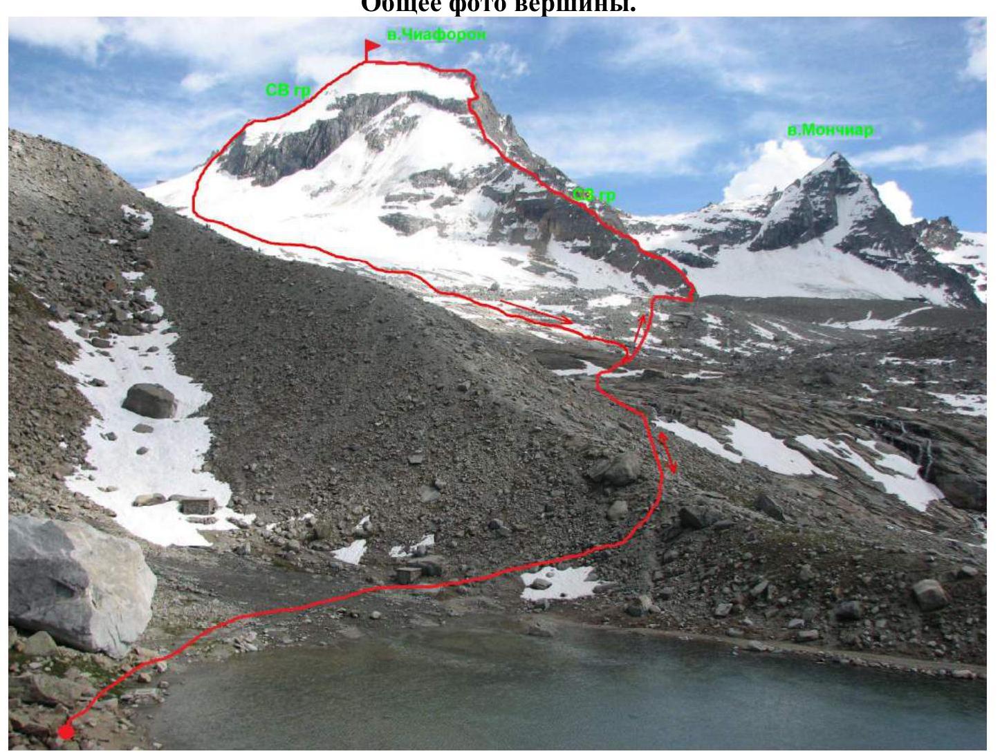
Photo taken from Vittorio Emanuele II hut on June 28, 2012.
Photo of the route profile (view from the 1B route on Gran Paradiso)
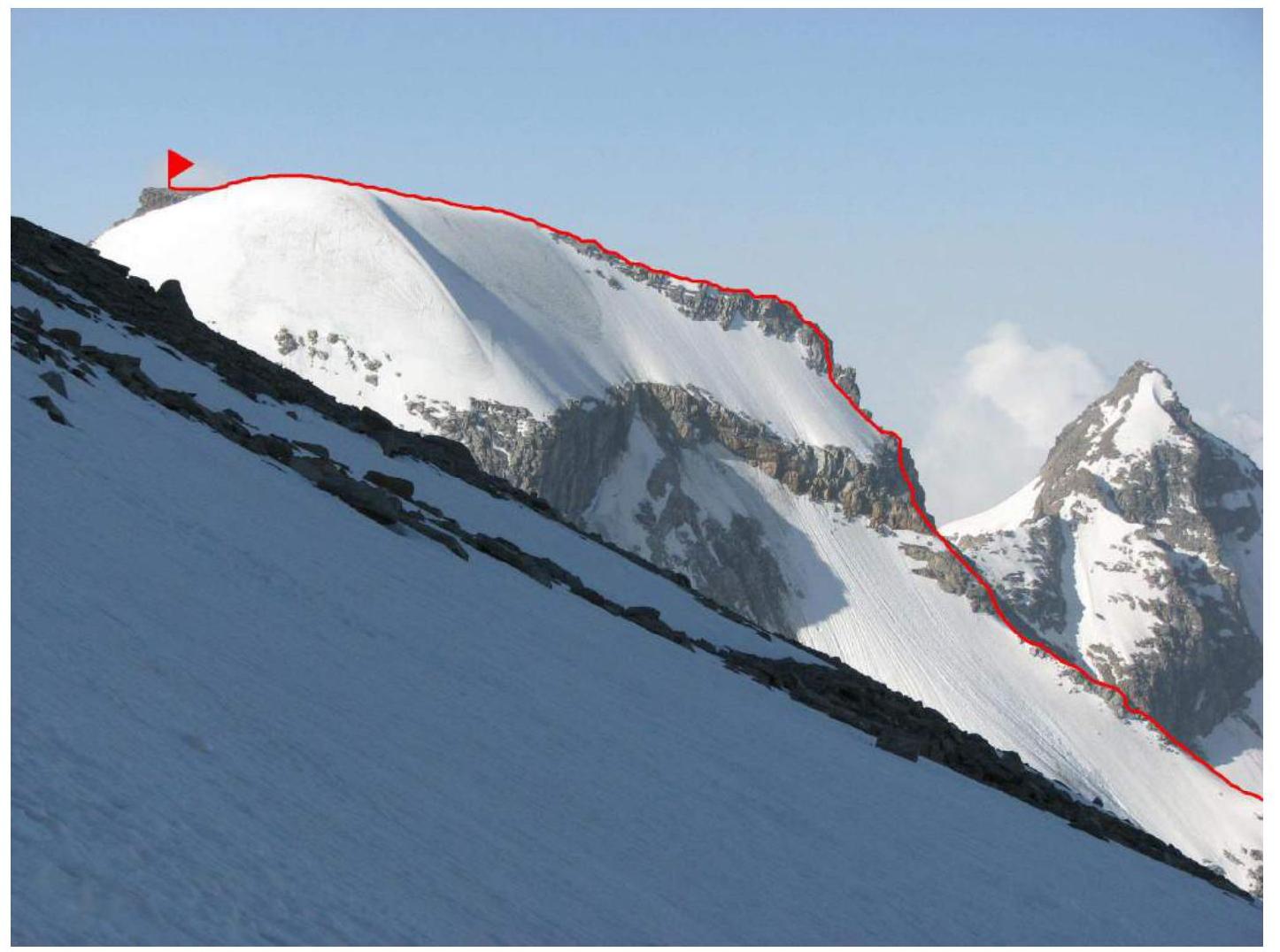
Panorama of the area.
Overview of the Gran Paradiso area.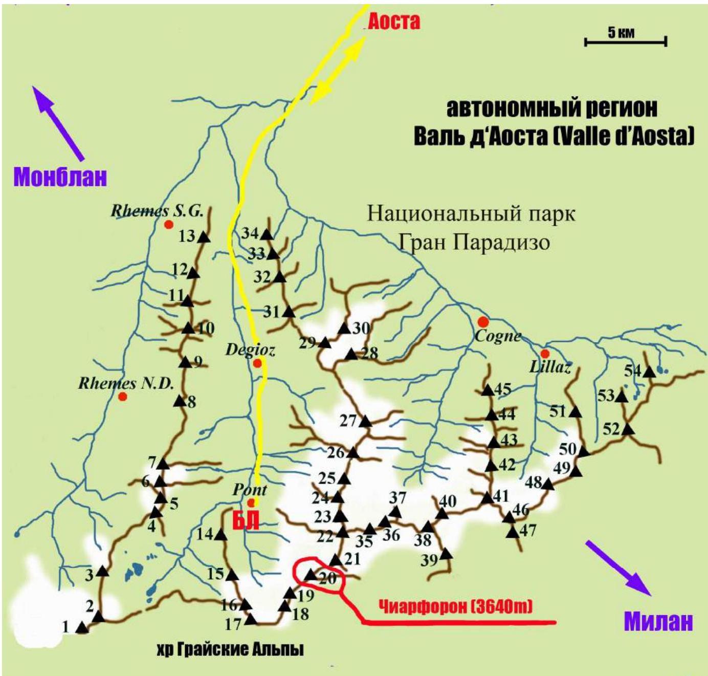
| Peak labels (with elevations) on the map: | |
|---|---|
| 1 — Punta Galisia 3346 m | 28 — Punta Rossa della Grivola 3630 m |
| 2 — Punta Basei 3338 m | 29 — La Grivola 3969 m |
| 3 — Punta Gran Vaudala 3272 m | 30 — Grivoletta 3514 m |
| 4 — Taou Blanc 3438 m | 31 — Gran Nomenon 3488 m |
| 5 — Aouillé 3440 m | 32 — Mont Favret 3173 м |
| 6 — Cima di Entrelor 3430 m | 33 — Punta Valletta 2793 m |
| 7 — Punta Percià 3227 m | 34 — Becca Piana 2271 m |
| 8 — La Roletta 3384 m | 35 — Punta Ceresole 3777 m |
| 9 — Punta Bianca 3427 m | 36 — Testa della Tribolazione 3642 m |
| 10 — Punta Bioula 3414 m | 37 — Testa di Valnontey 3562 m |
| 11 — Punta del Ran 3272 m | 38 — Becca di Gay 3621 m |
| 12 — Punta Chamoussière 2942 m | 39 — Becco Meridionale della Tribolazione 3360 m |
| 13 — Monte Paillasse 2414 m | 40 — Roccia Viva 3650 m |
| 14 — Cima dell'Arolley 2996 m | 41 — Torre del Gran San Pietro 3692 m |
| 15 — Cima di Seiva 3075 m | 42 — Punte Patri 3581 m |
| 16 — Punta Fourà 3411 m | 43 — Punta Valletta 3356 m |
| 17 — Mare Pércia 3385 m | 44 — Punta di Valmiana 3244 m |
| 18 — Denti del Breuil 3454 m | 45 — Punta Fenilia 3053 m |
| 19 — Becca di Monciair 3544 m | 46 — Punta d'Ondezana 3452 m |
| 20 — Ciarforon 3640 m | 47 — Becco di Valsoera 3369 m |
| 21 — La Tresenta 3609 m | 48 — Punta delle Sengie 3408 m |
| 22 — Becca di Moncorvè 3875 m | 49 — Monveso di Forzo 3322 m |
| 23 — Gran Paradiso 4061 m | 50 — Grande Arolla 3246 m |
| 24 — Piccolo Paradiso 3923 m | 51 — Punta della Tsesère 3117 m |
| 25 — Becca di Montandayné 3838 m | 52 — Torre di Lavina 3308 m |
| 26 — Herbetet 3778 m | 53 — Punta di Acque Rosse 2952 m |
| 27 — La Gran Serra 3552 m | 54 — Punta Nera 3064 m |
The summit of Ciarforon (Ciarforon) 3640 m, which was the destination of the ascent, is located in the Gran Paradiso National Park area. This park is situated in the Graian Alps mountain range in the autonomous region of Valle d'Aosta in northern Italy.
The highest point in the Gran Paradiso area is 4061 m, which is the seventh highest peak in the Alps (Mont Blanc being the first).
The Valle d'Aosta region is heavily mountainous, with iconic Italian and Alpine peaks such as Monte Bianco (Mont Blanc), Grand Jorasses, Cervino (Matterhorn), and Gran Paradiso.
Most routes of interest for mountaineers are located in the Gran Paradiso ridge. With peak elevations between 3500–4000 m, the area features a variety of terrain, including rocks, ice, and snow. There are many combined routes, with difficulties ranging from category 1 to 4, and some category 5 routes.
The ascent to the summit of Ciarforon was part of the CSKA training camp named after Demchenko (Moscow) in June-July 2012.
The base camp was located in a campsite in the village of Pont, which is the highest and last settlement in the Valsavaranche valley, at an elevation of 1950–2000 m.
The immediate access to the route was from the Vittorio Emanuele II hut, located at the foot of Gran Paradiso at an elevation of 2732 m. The approach from Pont takes about 2 hours via a convenient trail.
Ciarforon is situated in the ridge between the peaks of La Tresenta (3609 m) and Becca di Monciair (3544 m). The geographical coordinates of the summit are 45°29′35.09″ N 7°14′53.47″ E. In the Italian classification, the route via the NW ridge has a difficulty category of AD.
Route Description
| Section | Length, m | Angle, ° | Terrain | Category | Protection |
|---|---|---|---|---|---|
| R0–R1 | Rock-snow | I | |||
| R1–R2 | 350 | 30–45 | Rock | II | |
| R2–R3 | 150 | 25 | Rock-snow | II | |
| R3–R4 | 100 | 25 | Rock-snow | II | |
| R4–R5 | 80 | 60–70 | Rock | III | 1 set |
| R5–R6 | 50 | 50–60 | Rock | III | 1 set |
| R6–R7 | 50 | 35 | Rock | II | |
| R7–R8 | 100 | 45 | Snow-ice | III | |
| R8–R9 | 50 | 70–75 | Rock | IV | 1 set |
| R9–R10 | 50 | 30–45 | Rock | III | 1 set |
| R10–R11 | 400 | 15–20 | Rock-snow | II |
Technical Photo of the Route

Brief Description of the Route
R0–R1 From Vittorio Emanuele II hut, follow the trail to the moraine. Cross the glacier stream at the lower part and ascend the right side of the moraine to the beginning of the NW ridge of Ciarforon. Approximately 1.5–2 hours.
R1–R2 Elevation 2950 m. From the left side, about 30 m from the start of the ridge, move onto the ridge and proceed with caution due to loose rocks. Ascend simple rocks for 50 m to a gendarme. Bypass the gendarme on the left and continue up simple rocks for 300–350 m to snow on the ridge. Slope: 30–45°. Simultaneous protection.
R2–R3 Elevation 3170 m. Without reaching the snow, traverse rocks and reach scree slopes. Traverse the slopes for 100 m to a snowy ridge. Snowy ridge: 50 m, proceed with crampons or on rock outcrops with alternating protection, depending on the slope conditions.
R3–R4 After the snowy ridge, move along the scree slopes to the right towards a black couloir for 100 m. Approach the rock wall.
R4–R5 First critical section. Move up 70–80 m to the left of the wall (right of the black couloir), alternating protection, slope: 60–70°. Loose rocks require attention during protection and passage. Exit onto scree slopes.
R5–R6 Traverse scree slopes to a reddish couloir, pass it on the left for 50 m, 50–60°, and exit onto inclined ledges via simple rocks. Loose rocks.
R6–R7 Move right along inclined slabs for 50 m to reach snow.
R7–R8 Ascend snow for 100 m, moving left of the ridge, and reach the ridge under a wall, the second critical section. Closer to the rocks, there is less snow, and ice underneath.
R8–R9 Ascend a rock wall for 50 m, 70–75°, to a "gendarme." A convenient spot for protection via outcrops.
R9–R10 Bypass the gendarme on the right via inclined slabs and ascend to the ridge, 50 m.
R10–R11 Follow the flattening ridge for 400 m to reach the summit. The lake can be bypassed on either side. The summit is on rocks, marked by a pyramid with a "CAI" sign.
Descent via the NE ridge. From the summit, descend the snowy ridge to the first rappel. Then, descend rocks and snow for 3 more rappels to the northern slope, with fixed points. In fog, the descent is not visible, so it's essential to carefully study the NE ridge route description.
The route has rockfall-prone sections, requiring attention and caution.
Photo Illustrations
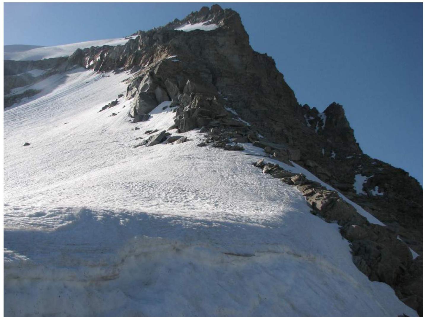
Photo 1. Section R3–R4
Photo 2. Section R4–R5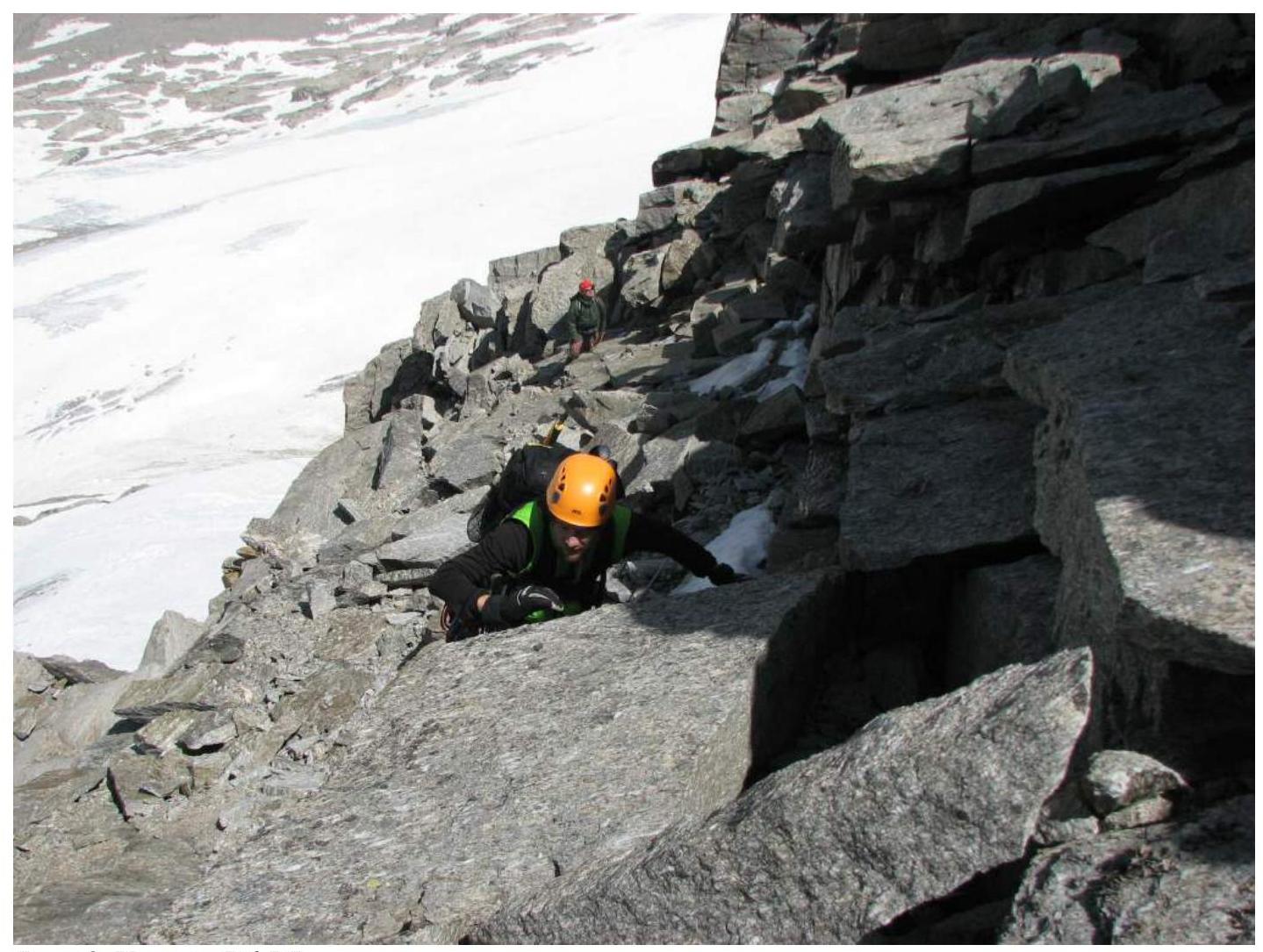
Photo 3. Section R6–R7
Photo 4. Critical section R8–R9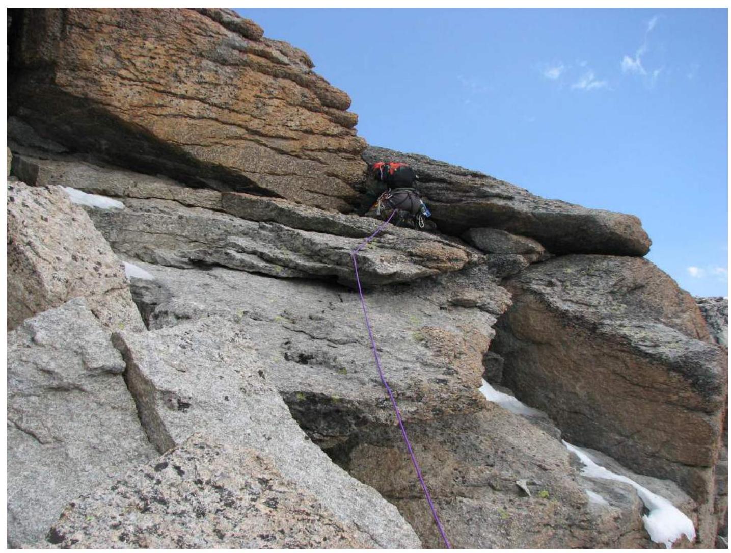
Photo 5. Section R9–R10
Photo 6. Section R10–R11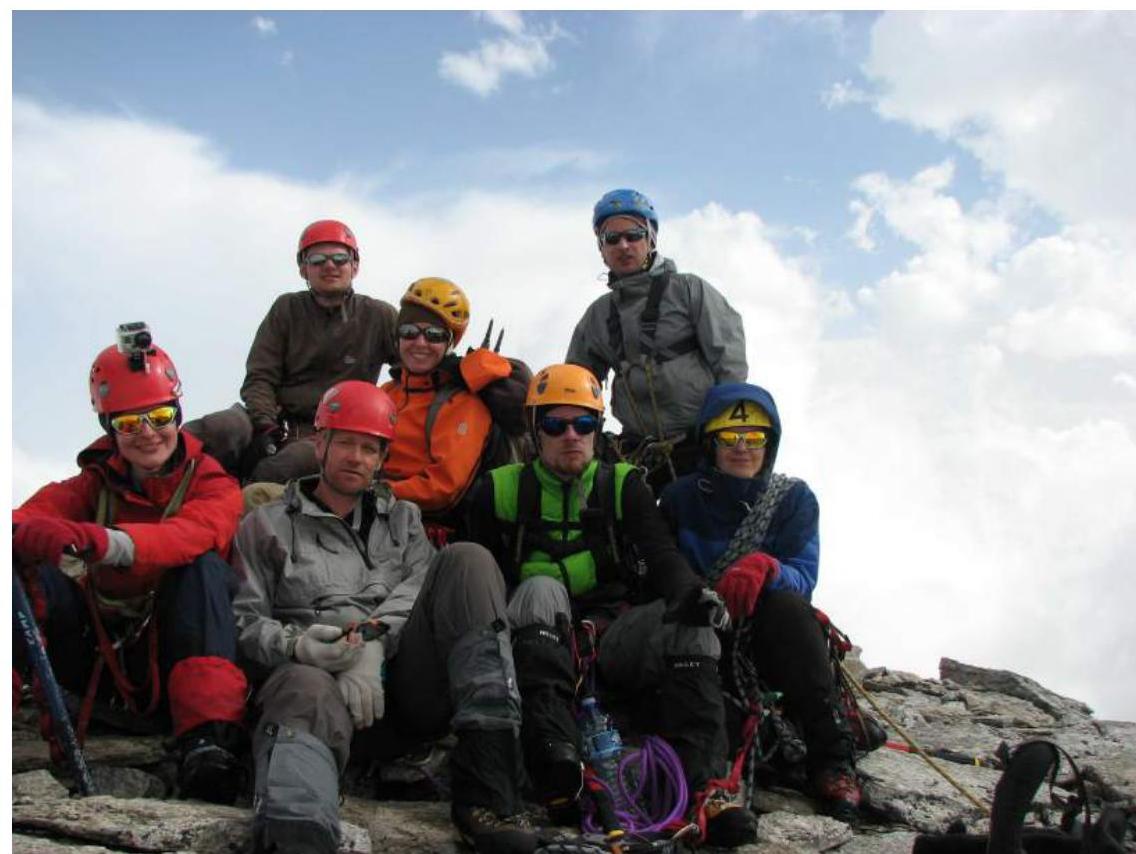
Photo 7. Team at the summit
Comments
Sign in to leave a comment