Ascent Passport
-
Ascent class: rock
-
Region: Alps, Chamonix (France)
-
Route: via North-West wall (Piola–Steiner route)
-
Difficulty category: not classified, proposed 6A
-
Height difference: 840 m, length: 1240 m
length of sections with 5 difficulty category — 565 m, length of sections with 6 difficulty category — 380 m average steepness of main sections — 78°
-
Pitons used:
| Rock | Nuts | Ice |
|---|---|---|
| 61/6 | 147 | 9 |
-
Team's walking hours, days — 1
-
Overnight stay: "sitting" on descent — 1
-
Leader: Pigarev Alexander Anatolyevich — CMS
participant: Velmik Viktor Vasilyevich — CMS
-
Coach: Grishchenko Viktor Ivanovich, IMSM
-
Approach to the route: August 15, 1995
Summit: August 15, 1995 Return: August 16, 1995
-
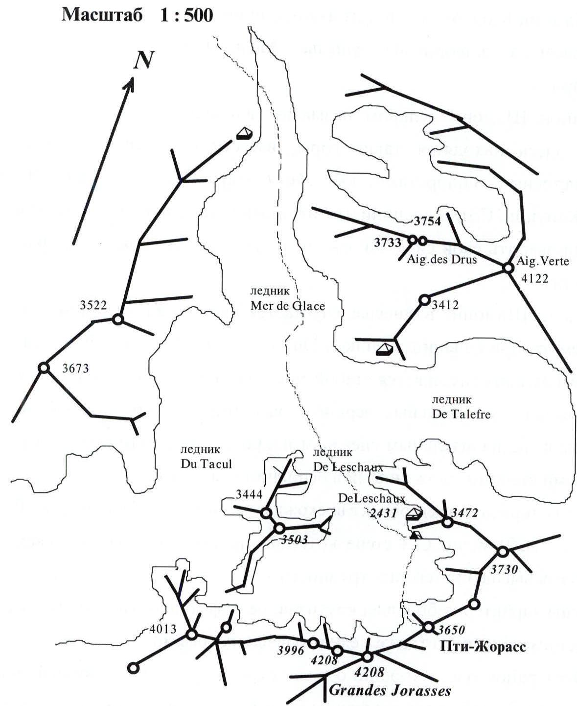
Ascent made by EuroPolis ASC team from Kiev
Photopanorama of the ascent region

| 1 | - | Grand Jorasses (4208 m); |
|---|---|---|
| 2 | - | Petites Jorasses (3650 m); |
| 3 | - | De Leschaux (3759 m); |
Brief overview of the ascent region
Chamonix-Mont-Blanc, one of France's most famous mountain resorts, is located in a picturesque Alpine valley, near the border with Switzerland.
The Chamonix area is often referred to as the mecca of mountaineering, as it is home to mountains known for their challenging climbing routes, such as Mont Blanc, Petit Dru, Grand Jorasses, and Grand Capucin. Hundreds of climbers from around the world come here to test their skills on these and many other challenging and beautiful routes.
Above Chamonix, in the valley, lies the tongue of the Mer-de-Glace glacier, formed by the confluence of the Du Tacul and De Leschaux glaciers. The upper cirque of the Leschaux glacier is closed by the wall of the Grand Jorasses massif (4208 m). To the left lies a chain of rocky peaks, ranging in height from 3400 to 3800 m. These are peaks with minimal snow cover and steep, monolithic rock walls, primarily composed of granite.
Here is located the object of the ascent — the peak Petites Jorasses (3650 m), on whose NW wall several rock routes of the highest difficulty category are laid.
The wall is characterized by great steepness, relief of monolithic slabs with few holds, as well as small and medium cracks.
This area is very well developed, with a mountain hut located in front of the cirque; the approach to the wall from the hut along the glacier takes about 1.5 hours.
Map-scheme of the ascent region
Photograph of the summit
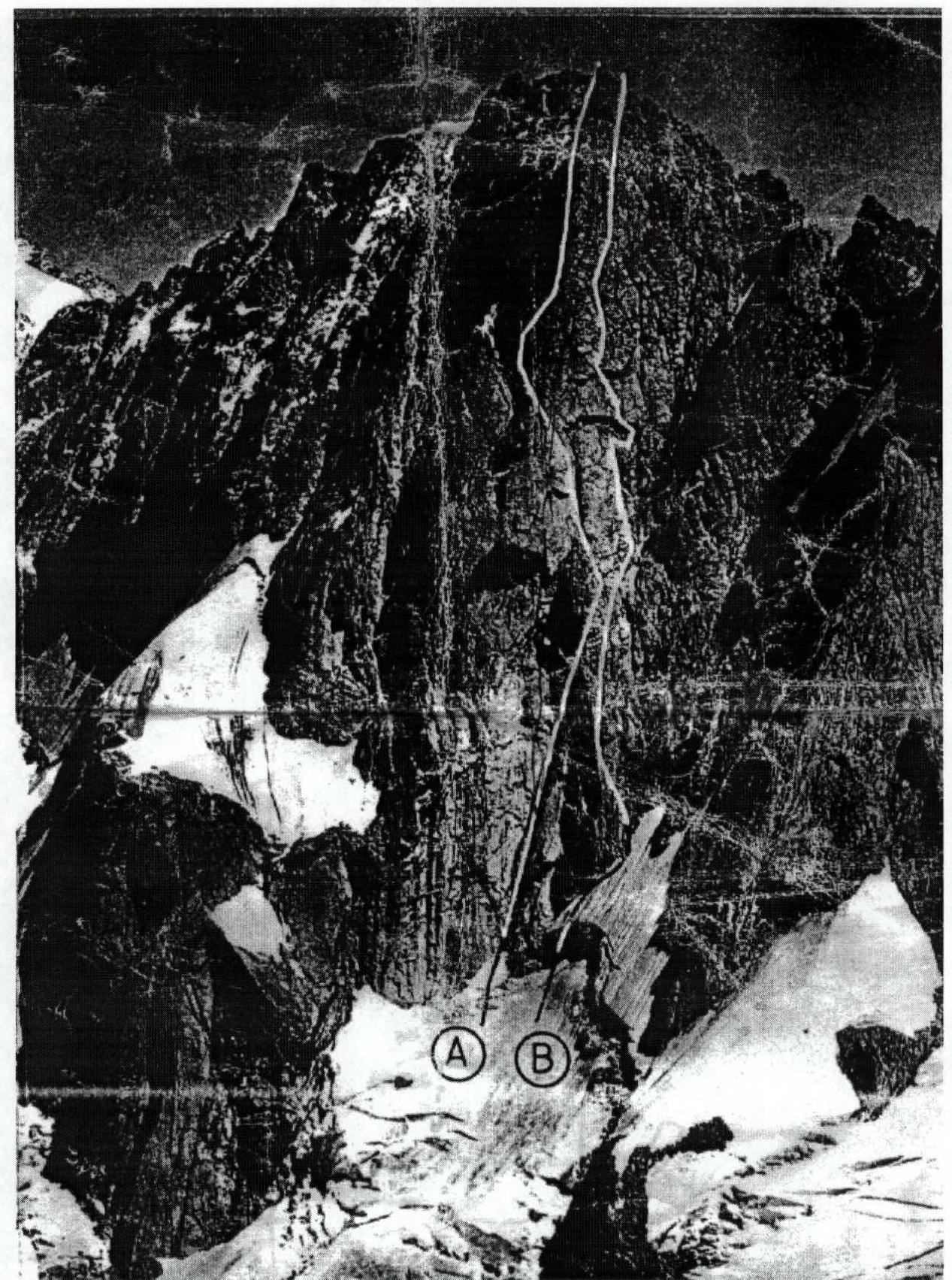
- M. Bron–A. Contamine–P. Labrunie route (1955)
- Team's ascent route (C. Dalphin–M. Piola–P. Steiner, 1981)
Drawn profile of the route

Preparation for the ascent
In the spring of 1995, training was conducted in Crimea, where the technique of navigating complex rock sections on challenging wall routes was practiced ( мыс Айя, Куш-Кая ). Throughout the winter, the team systematically conducted training for general physical preparation. After arriving in the high-altitude zone, a training ascent of category 3 difficulty was made to the shoulder of Petit Dru to practice rock technique.
The ascent of Petites Jorasses via the North-West wall (Piola–Steiner route) is one of the most challenging routes to this summit. At the same time, it is logical and allows demonstrating free climbing technique on complex rock walls, which is why it was chosen.
The route places high demands on the physical, technical, and psychological preparation of the climbers. Additionally, when developing tactics, it was necessary to consider the impact of unstable weather in this area. These features dictated the team's ascent tactics.
The wall's great length and climbing complexity required very coordinated work from the pair to ensure the speed and safety of the route's passage.
The lack of ledges for setting up a tent demands high standards for the climbers' personal equipment. These features influenced the team's preparation for the ascent.
The final choice of route and tactics was made after a detailed examination of the wall, route description, and consultations at the De Leschaux hut.
Ascent schedule
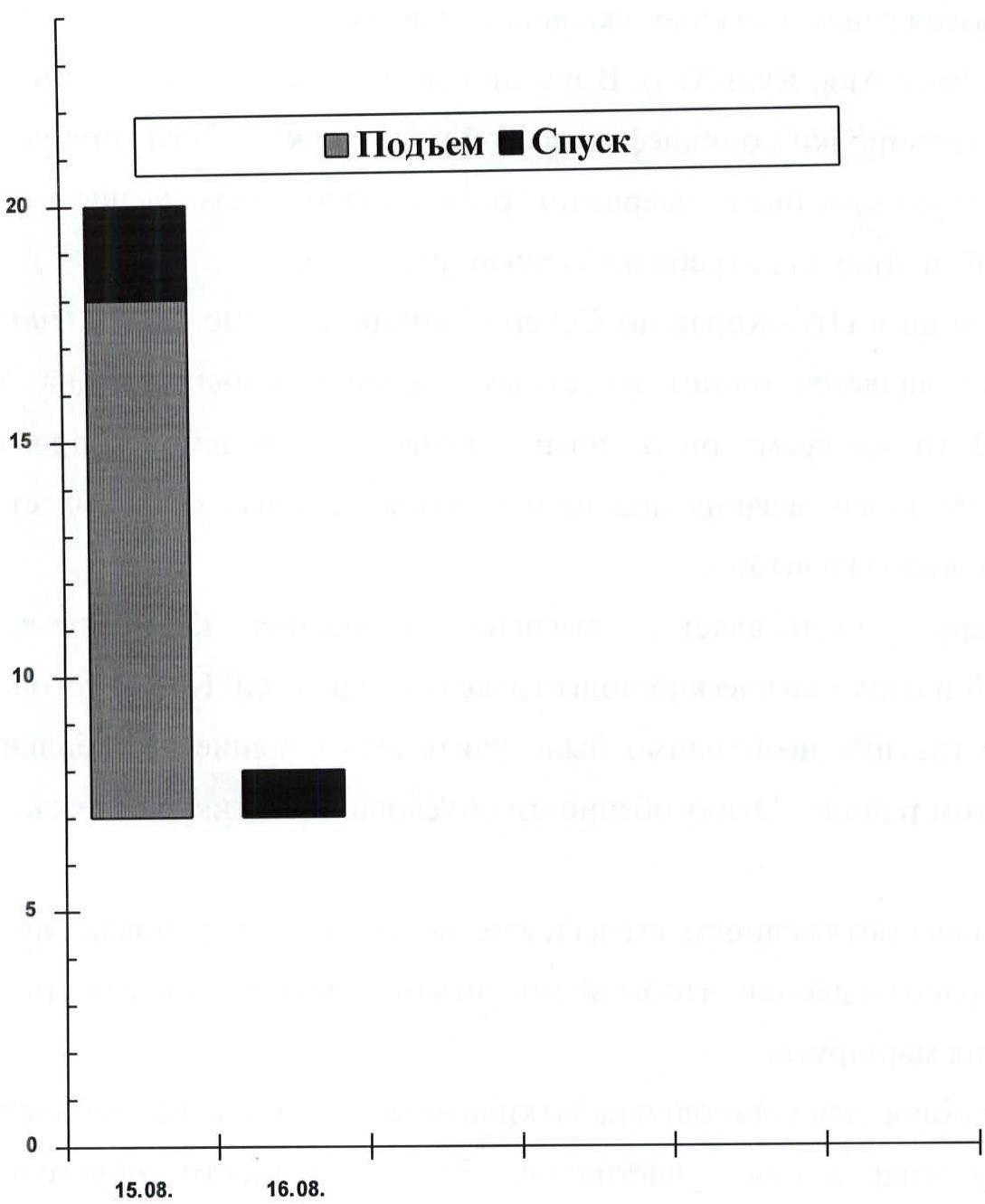 August 15. Ascent to the summit, beginning descent via the ascent route.
August 16. Descent to the camp.
August 15. Ascent to the summit, beginning descent via the ascent route.
August 16. Descent to the camp.
Team's tactical actions
The tactical plan for the ascent was made considering the route's terrain features:
- early morning departure from the overnight stay near the De Leschaux hut (2431 m) to traverse the glacier under the wall before sunrise, climbing the rock wall — 1 day;
- descent through the center of the wall using fixed pitons and back to the camp via the glacier early in the morning — 1 day; Total: 2 days. The meteorological forecast at the hut before the ascent indicated two days of good weather with possible further deterioration.
The tactical plan did not include preliminary processing of route sections.
Safety measures were given significant attention. To ensure safety during the lead climber's ascent, a rope meeting UIAA requirements was used, along with a wide range of modern rock climbing equipment tested during preparation (friends, sail-nuts).
Radio communication was maintained with the base camp in Chamonix and the "Kiev-1" team, which was ascending Grand Jorasses from August 15–17.
Movement during the ascent was organized as follows:
- While ascending the glacier to the base of the wall, they moved simultaneously in a rope team. When traversing the ice wall at the upper part of the glacier and the bergschrund, they used fixed ropes. Belay via ice screws.
- The lead climber ascended without a backpack on a double rope. Belay for the lead climber — via a Sticht brake or figure eight;
- The second climber in the pair approached the first by climbing with top-rope belay; in complex areas, they ascended on jumars along fixed ropes anchored to at least three blocked pitons or nuts;
- The team had a first-aid kit, and each participant was equipped with bandaging materials and emergency rations;
Throughout the ascent, there were no falls or injuries in the group. The route was largely completed with free climbing. Communication with the base was regularly maintained via Motorola VHF radio station at 8:00, 12:00, 18:00, 20:00, with monitoring at the base camp and by the "Kiev-2" group every two hours.
The weather during the ascent was good. The route, as planned, was completed with one overnight stay on descent (on an inclined ledge — section R9). The tactical plan was executed without deviations.
Route scheme in UIAA symbols
Total time of team's walking hours: 11 h
| Section number | Number of pitons used | UIAA Symbols | |||||
|---|---|---|---|---|---|---|---|
| Rock | Nuts | Ice | Difficulty category | Length of section, m | Steepness, ° | ||
| 1 | 2 | 3 | 4 | 5 | 6 | 7 | 8 |
| Walking time 11 h. Number of pitons 9/0 pcs. | |||||||
| R19 | 1 | 5 | 0 |  | III | 150 m | 35 |
| R18 | 2 | 12 | 0 |  | V- | 80 m | 65 |
| R17 | 2 | 14 | 0 |  | V | 90 м | 70 |
| R16 | 4 | 12 | 0 |  | V+ | 80 м | 75 |
| R15 | 2 | 18 | 0 |  | VI | 90 м | 80 |
| R14 | 3 | 7 | 0 |  | VI | 40 м | 90 |
| R13 | 6/3 | 5 | 0 |  | VI+ A2 | 45 м | 95 |
| R12 | 3 | 12 | 0 |  | VI+ | 60 м | 90 |
| R11 | 3/3 | 8 | 0 |  | VI+ A2 | 40 м | 85 |
| R10 | 4 | 10 | 0 |  | VI | 60 м | 80 |
| R9 | 5 | 15 | 0 |  | IV | 45 м | 45 |
| R8 | 5 | 5 | 0 |  | V- | 80 м | 70 |
| R7 | 4 | 5 | 0 |  | V- | 90 м | 75 |
| R6 | 5 | 7 | 0 |  | V+ | 40 м | 80 |
| R5 | 5 | 5 | 0 |  | V | 45 м | 75 |
| R4 | 5 | 4 | 1 |  | VI | 45 м | 90 |
| R3 | 2 | 3 | 3 |  | V- | 40 м | 65 |
| R2 | 0 | 0 | 3 |  | V | 20 м | 80 |
| R1 | 0 | 0 | 2 |  | III | 100 м | 30 |
| Total | 61/6 | 147/0 | 9/0 |
Description of the route by sections
R1 Icefall. Movement in crampons, in a rope team, simultaneously. The ice wall at the upper part was traversed with fixed rope belay via ice screws.
R2 Steep ice-snow slope with a bergschrund in the middle part. Bergschrund and further passage to the rocks with fixed rope belay via ice screws.
R3 Ice slope and "ram's foreheads" with rimed ice. Then a complex wall with small holds, traversed with free climbing.
R4 Steep internal corner, followed by a complex wall.
R5 Combination of slabs and walls, exit to a vaguely defined rock rib.
R6 Monolithic rock walls with small holds, movement with bypassing overhanging rocks on the left.
R7 Internal corner, followed by a complex wall with a crack, inclined slabs.
R8 Combination of inclined slabs and walls. Movement towards a large snow ledge.
R9 Along the inclined ledge, traverse right upwards.
R10 Complex steep internal corner, followed by a monolithic wall with small holds.
R11 Monolithic wall, overhang bypassed on the left via a crack, very complex climbing, several meters traversed with aid climbing.
R12 Ascent upwards for about 40 m along a difficult wall with small holds, then two pendulum swings right under the first cornice. Ascent under the cornice via climbing a very complex wall.
R13 Very complex cornice (2 m out) traversed with aid climbing. Then very complex climbing along the wall.
R14 Steep monolithic slabs with small holds.
R15 Ascent along a complex internal corner. Complex climbing. Then exit to a narrow rock ledge.
R16 Wall with a wide crack. Traversed with free climbing along the wide crack. Friends work well. Monolithic slabs.
R17 — vaguely defined complex internal corner, transitioning into a wide crack. Complex climbing.
R18 — inclined monolithic slabs with small rock walls having small holds. Exit to the summit ridge via the wall.
R19 — destroyed summit ridge. Ascent to the summit.
Equipment table
| Equipment name | Quantity, pcs. | Weight, kg | Section of use |
|---|---|---|---|
| Main rope: domestic 45 m; Edelrid (UIAA) 45 m | 1 1 | 2.5 3.5 | R1, descent |
| Ice axe | 1 pcs. | 1.0 kg | R1–R3 |
| Rock hammer | 2 pcs. | 1.5 kg | R3–R19 |
| Rock pitons | 10 pcs. | 0.5 kg | R3–R19 |
| Nut placements | 10 pcs. | 1.0 kg | R3–R19 |
| Friends (set) | 1 pcs. | 1.0 kg | R4–R18 |
| Ice screws | 3 pcs. | 0.3 kg | R1–R3 |
| Carabiners | 25 pcs. | 2.0 kg | R1–R19 |
| Extender | 12 pcs. | 0.5 kg | R1–R14 |
| "Jumar" clamp | 1 pcs. | 0.2 kg | R2, R10–R15 |
| Descender | 2 pcs. | 0.2 kg | descent |
| Crampons | 2 pcs. | 2.0 kg | R1, R2, R3 |
| Gas burner | 1 pcs. | 0.2 kg | at bivouac |
| Epigas gas cylinder | 1 pcs. | 0.2 kg | at bivouac |
| First-aid kit | 1 pcs. | 0.5 kg | |
| Headlamp | 1 pcs. | 0.3 kg | |
| Motorola radio station | 1 pcs. | 1.0 kg | R1–R14, descent |
| Set of personal equipment, personal items, sleeping bags | 2 pcs. | 10 kg | R1–R14, descent |
| Food supplies | 1 kg | R1–R14, descent | |
| Total weight | 23.4 kg |
Initial weight of backpacks: 12 kg