
- Karakorum mountain system
- Hidden Peak, 8068 m
- Cat. of diff. — 6A approximately
- Route type — combined
- Route elevation gain — 2768 m Route length — 12180 m. Section lengths:
- V cat. of diff. — 80 m
- VI cat. of diff. — 0
- Pitons left on the route: total — 25
Pitons used:
| Rock | Bolt | Ice | Chockstones | Friend | Snow |
|---|---|---|---|---|---|
| 18 | 0 | 5 | 0 | 0 | 22 |
| 0 | 0 | 0 | 0 | 0 | 0 |
- Team's climbing hours on the route: 1114
- Team leader Uryubko Denis — Honoured Master of Sports
Team members:
- Bogomolov Sergey — Honoured Master of Sports
- Lavrov Sergey — Honoured Master of Sports
- Molgachev Damir — Master of Sports Candidate
- Rudakov Aleksandr — Master of Sports Candidate
- Pivtsov Vasily — Master of Sports Candidate
- Raspopov Aleksey — Master of Sports Candidate
- Litvinov Vasily — Master of Sports Candidate
- Zhumaev Maksut — Master of Sports Candidate
- Coach: Ilyinsky Ervand Tikhonovich — Honoured Master of Sports, Honoured Coach of the USSR
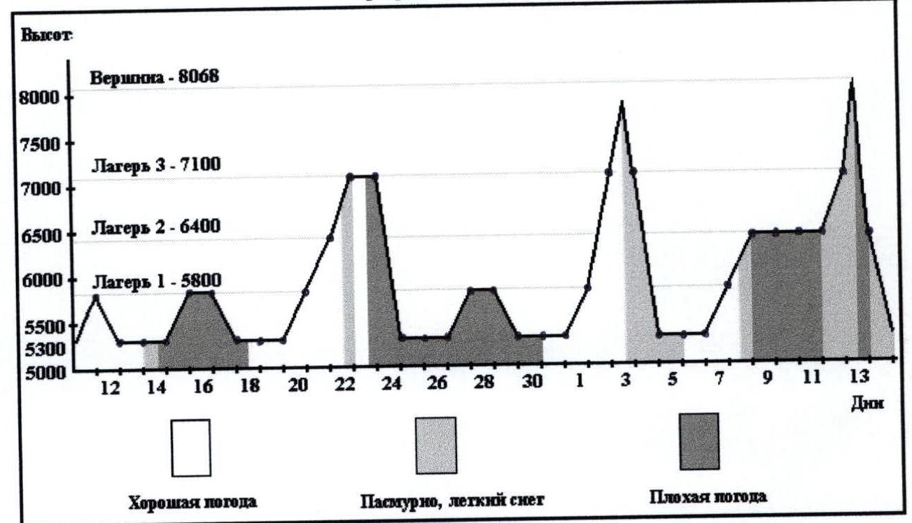
- Start of work on the route: July 11, 2000, 10:00. Shoulder start — August 7, 2001, 5:00. Summit — August 13, 2001, 7:20. Descent to Base Camp: August 14, 2001, 13:00.

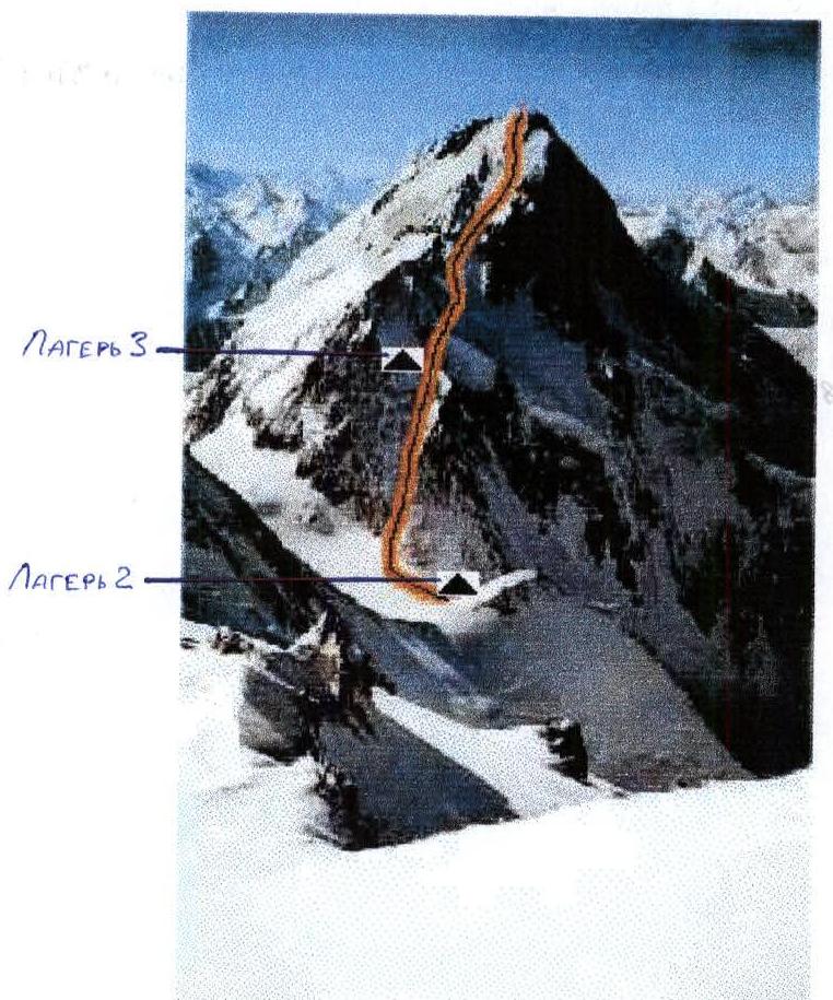
View of Hidden Peak from the West, from Camp 1 (5800)
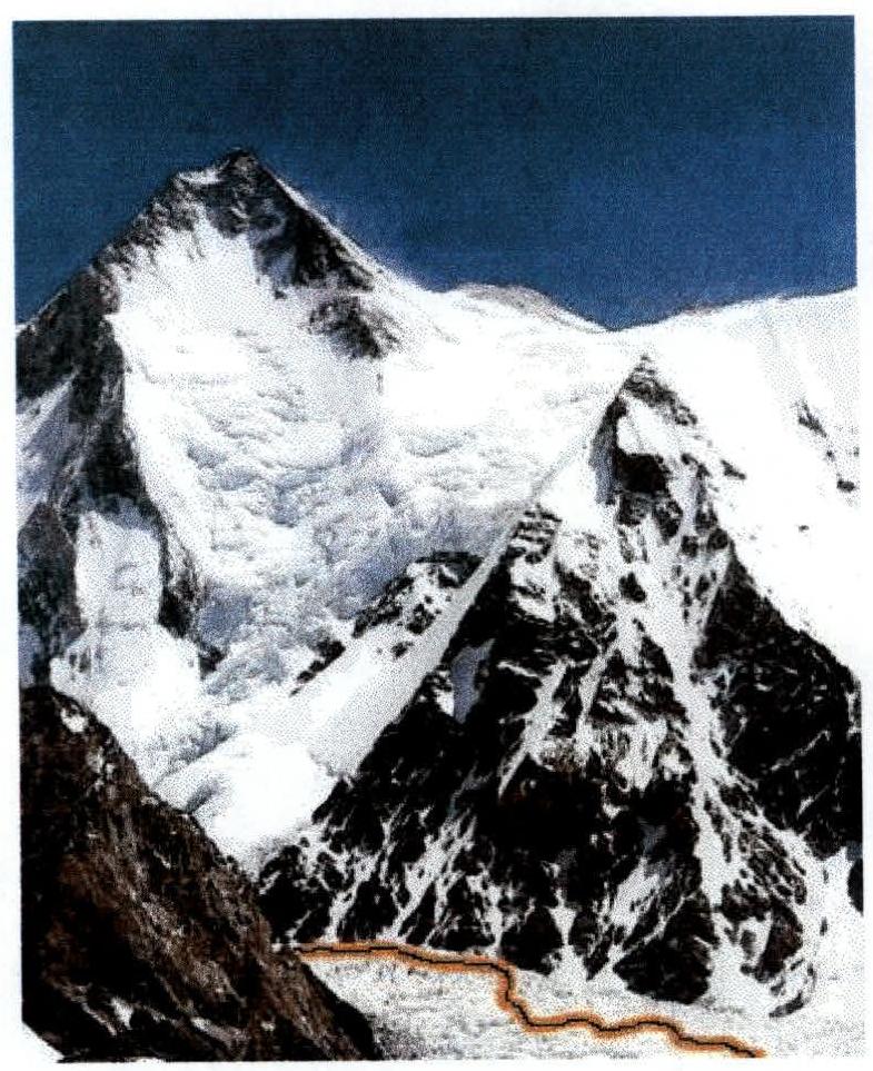
View of Hidden Peak from the North, from Gasherbrum 2, from 8000 m height. Panoramic view of the area
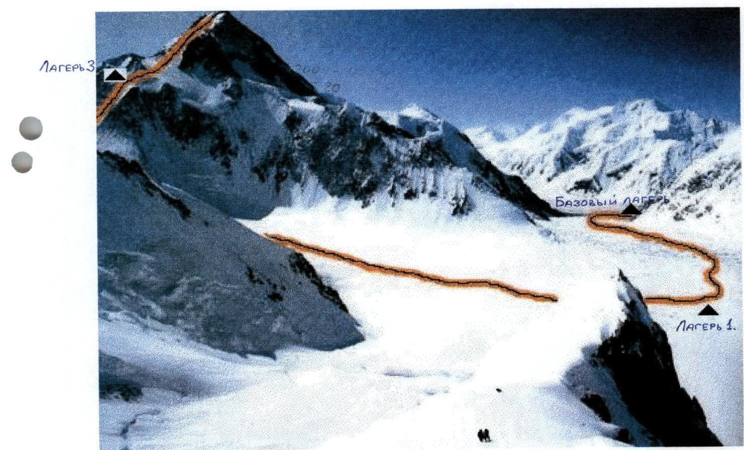
View of Hidden Peak from Base Camp, from 5300 m height, from South-West
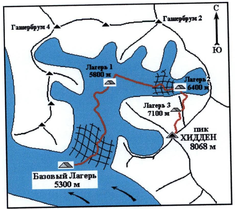
View of Hidden Peak from North-West, from Camp 2 on Gasherbrum 2, from 6400 m height. Area map
Ascent graph
Group equipment
| № | Name | Quantity (pcs) | Weight (kg) |
|---|---|---|---|
| 1 | High-altitude tent | 6 | 24 |
| 2 | Gas burner | 4 | 1.2 |
| 3 | Gas cylinders | 40 | 20 |
| 4 | Cookware | 4 sets | 1.6 |
| 5 | Rope 50 m – 10 mm | 6 | 15 |
| 6 | Rock hammer | 2 | 1 |
| 7 | Rock pitons | 12 | 1.1 |
| 8 | Snow pitons | 8 | 3 |
| 9 | Ice pitons | 10 | 0.6 |
| 10 | Carabiners | 15 | 0.9 |
| 11 | Extension slings | 8 | 0.4 |
| 12 | Radio station | 4 | 2.4 |
| 13 | Spare power for radio station | 2 | 0.6 |
| 14 | Disposable rope 200 m – 6 mm | 1 | 3.5 |
| 15 | First aid kit | 2 | 1.5 |
| 16 | Snow shovel | 2 | 0.6 |
| Total | 77.4 |
Brief description of the ascent area
The Karakorum mountain uplift is one of the largest in the world, ranking second in height after the Himalayas. It is located in Central Asia, in a mountain node that connects the Himalayas, Hindu Kush, and Tian Shan, and the Pamir into a single whole. In terms of area and length, Karakorum is certainly inferior to many systems — the Cordilleras, the Andes, etc. The system of ridges has a somewhat elongated character, from west to east, without a clear orographic pattern. Like the Himalayas, Karakorum is not a defining feature in the division of global water basins; the Indus River makes its way through it. The character of the mountains here is alpine — with sharp peaks and steep rocky walls with a large elevation gain. This is due to the youth and strength of the constituent rocks. Granites with basalt outcrops are predominantly found here. The process of mountain building, which began with the collision of two continental platforms — the Indian and Asian — continues, and its intensity outpaces the process of erosion. Weather conditions are poor, characterized as extremely unstable. The location of Karakorum on the border of two global climatic zones (the Taklamakan Desert with Tibet and the open southern plains exposed to the wet monsoon) contributes to a large amount of precipitation, accumulated in the form of glaciation. Sharp deterioration of weather and high avalanche danger have repeatedly led to the death of qualified climbers. The highest peak of Karakorum is Chogori (K2, Godwin-Austen) — 8611 m. There are also three other peaks exceeding 8000 meters — Hidden Peak (8068 m), Broad Peak (8047 m), and Gasherbrum 2 (8035 m). Karakorum — mountains known since ancient times, yet their study remained very superficial for a long time due to the inaccessibility of its central regions. One of the branches of the Great Silk Road passed through the valleys of the southern part of the mountain range, but it was not until the beginning of the 20th century that the first researchers appeared, systematically expanding knowledge about Karakorum. Among climbers, the following are most popular here:
- Chogori (K2, Godwin-Austen)
- Hidden Peak*
- Broad Peak
- Gasherbrum 2
- the Trango area, whose rocky towers attract with their steepness and scale
- Chogori, with its reputation as the "Killer Mountain" that beckons climbers
- the peaks of Broad Peak and Gasherbrum 2, whose relative accessibility allows even less prepared athletes to hope for success. The simplest and most established route to the foot of the "eight-thousanders" passes along the Karakorum Highway from Islamabad to the village of Skardu, from where, on high-passage vehicles — to the village of Askole (about 60 km). The further path of the expedition usually proceeds on foot, although it is possible to be airlifted by helicopter. From Askole, the trek passes through the village of Paiyu to the Baltoro Glacier, along which in three to four days of travel one can reach a height of 5300–5500 meters either to Base Camp under K2 or under the slopes of the Gasherbrum massif.
Preparation for the ascent
The national team of the Republic of Kazakhstan for mountaineering undergoes year-round constant training in all types of mountaineering activities. The expedition was planned several years before the summer of 2001 and was thoroughly prepared.
In 1999, the team of the Central Sports Club of the Ministry of Defense of the Republic of Kazakhstan (CSK MO RK), whose athletes make up a large part of the national team, made ascents:
- in winter on Peak Sv. Korei via the Bagaev route (5B),
- in spring on Peak Usechenka (5B),
- in summer, along with other seven-thousanders of the CIS as part of the "Snow Leopard" program, they also climbed Khan-Tengri and Peak Pobeda in one summer season.
In 2000, the team:
- climbed Peak Sv. Korei via the Ruchkin route (6A) in winter,
- traversed the North Face of Khan-Tengri at 6B.
When developing plans for 2001, the senior coach of CSK MO RK for mountaineering, E.T. Ilyinsky, chose Hidden Peak as the object of ascent for the summer season.
The autumn-winter period was characterized by intense physical special loads, as well as regular ascents in the Tuyuk-Su area (from 1B to 4B). A trip was made to the Ala-Archa gorge, where they climbed Peak Korona, 5 Bashnya via a 6A category route. They also won the Open Face-to-Face Championship of Kyrgyzstan in mountaineering. Climbing Peak Marble Wall via 5A in winter was also part of the preparation for Karakorum. In previous years, some team members had experience climbing several eight-thousanders in the Himalayas, and the senior coach had experience leading high-altitude expedition there and in the USSR. Numerous literary sources also provided necessary information on the area. The team studied the tactical and climatic conditions of the ascent, received necessary consultations. Based on all this, the group selected the necessary equipment and developed a tactic for passing the route.
Ascent execution
July 9. Base Camp of the expedition was established at a height of 5300 m.
July 11. Expedition participants reached Camp 1 at a height of 5800 m, also known as Advanced Base Camp. The road here passes through an icefall and a heavily broken closed glacier. Travel time — 5 hours. The next day, everyone descended back to Base Camp.
July 15. The team set out from Base Camp at 5:15 in good weather and reached Camp 1 by 10:00, carrying a large amount of food and equipment. The next day, snowfall began, and after spending a day in the tents of the first camp, on July 17, the group descended down by lunchtime.
July 20. After two days of rest, the team resumed the route, ascending to 5800 m to Camp 1.
July 21. The path from Camp 1 to Gasherbrum-La Pass, where climbers establish Camp 2 at 6400 m, passes:
- along a wide, flat glacier with practically no crevices,
- then along a weakly broken icefall along its right (in the direction of travel) part.
The group ascended to the pass in 5 hours from Camp 1 and established Camp 2. The next day, the front five — Raspopov, Lavrov, Litvinov, Pivtsov, and Molgachev — ascended via the "Japanese" couloir, supplementing old fixed ropes, to a height of 7100 m, where they established Camp 3. Zhumaev and Uryubko helped with the carry-up to 6800 m and descended to Camp 2 for the night, joining the trio Bogomolov, Tortaladze, and Sedusov.
July 23. Early in the morning, the five led by Raspopov descended down to Base Camp, while the group Uryubko — Zhumaev — Tortaladze — Bogomolov — Sedusov ascended from Gasherbrum-La Pass to Camp 3, spent the night, and returned to Base Camp by the evening of the next day.
July 27. Raspopov's group set out for Camp 1 but was forced to return to Base Camp after a day of sitting out bad weather.
August 1. Departure at 6:00, reached Camp 1 by 10:30. Sedusov and Tortaladze fell ill and were forced to remain in Base Camp. The next day, without incident, the group bypassed the second camp and ascended to Camp 3 (7100 m), from where on August 3, 2001, at 4:30, they set out to storm the summit.
Upon reaching the edge of the plateau at 7200 m, fixed ropes were installed. Unfortunately, the progress along sections of steep slope at heights of 7300–7600 m proved to be much more hazardous than anticipated by the participants and leadership:
- after several days of hurricane-force winds, the snow was completely blown away,
- icy sections were exposed.
Here, for normal fast work, the available equipment — ropes, fixed and ice pitons — was insufficient. Therefore, under deteriorating weather conditions and considering the late departure from the bivouac, it was decided to return down. At 12:00, the group in full strength, having reached a height of about 7700 m, began descending to Camp 3, which they reached around 17:00. By 16:00 on August 4, everyone safely descended to Base Camp.
August 7. The team, taking advantage of a favorable weather forecast, set out on the ascent. After spending the night in Camp 1, they reached Camp 2, where strong bad weather began. The team remained in Camp 2 (6400 m) until the morning of August 12 and only on that day managed to ascend to Camp 3, from where on August 13, 2001, at 00:20, they set out to storm the summit.
This time, the group was better equipped. Fixed ropes were installed along the couloirs from 7300 to 7600 m, and, moving further in pairs (sometimes simultaneously, sometimes with alternating insurance via an ice axe), the participants reached the summit — 8068 m — at 7:20. The weather was good.
The descent was made along the ascent route, and after evacuating Camp 3, by 18:00, everyone descended to Gasherbrum-La Pass, to Camp 2 (6400 m). And on August 14, 2001, at 13:00, the group safely returned to Base Camp. There were no failures, injuries, or illnesses.
Radio communication with Base Camp was carried out regularly at 8:00, 12:00, 16:00, and 20:00.
Litvinov V. — I can say that the team acted cohesively and communicatively. It was a good ascent. Everything went great.
Lavrov S. — The fact that we completed this route is, in my opinion, a good sporting achievement. We had enough food and gas, everything was competently calculated and anticipated. I hope to work together again in the same lineup on a future ascent. I draw the attention of younger participants to some shortcomings in bivouac tactics; I hope that over time, everything will improve.
Pivtsov V. — The overnight stays were comfortable. Even in bad weather, the team was able to choose an optimal movement plan. It was correct to decide to turn back under the conditions we faced during the first summit attempt. Personal equipment of the participants still leaves much to be desired, and many minor but unpleasant moments during the ascent could have been avoided if the team had used normal modern equipment and clothing.
Raspopov A. — The lengthy training process before the expedition was not in vain. The level of training of the team and the ascent to a peak above 8000 m allow us to hope that the collective is capable of even more challenging routes. Of course, it was difficult to distribute equipment, gas, and food for the ascent during such a lengthy expedition, but we managed to solve this.
Molgachev D. — Tactically, everything was correct, and despite the bad weather this season in Karakorum, we worked well; I would like to work on such a route at 8000 m again.
Zhumaev M. — It was very pleasant that we were able to endure those four days in Camp 2 (6400 m) when we were battered by bad weather and then set out to storm the summit and achieve success.
Uryubko D. (team captain) — The ascent was very reliable. I'm glad to have led such an ascent — the participants are disciplined and conscious. Team members worked cohesively and focused on the summit. Good relationships within the collective were the key to success that helped us throughout this ascent. The ascent demonstrated good physical and technical preparation. Despite having to turn back during the first summit attempt, I believe this was done absolutely correctly and was the only right decision. Therefore, the ascent was accident-free, and with more favorable weather, it would have been possible to complete the expedition in a shorter timeframe.
Ilyinsky E.T. (expedition leader) — The ascent and leadership are to be considered successful. I hope that in the future, the group will be more competent in relation to the timing of the summit push and the equipment necessary for working on challenging sections. It is necessary to anticipate in advance the unfavorable moments that may be encountered at heights above 7000 m. Undoubtedly, the team needs more modern and comfortable equipment for such ascents.
Route scheme in UIAA symbols
(No ITO were used)
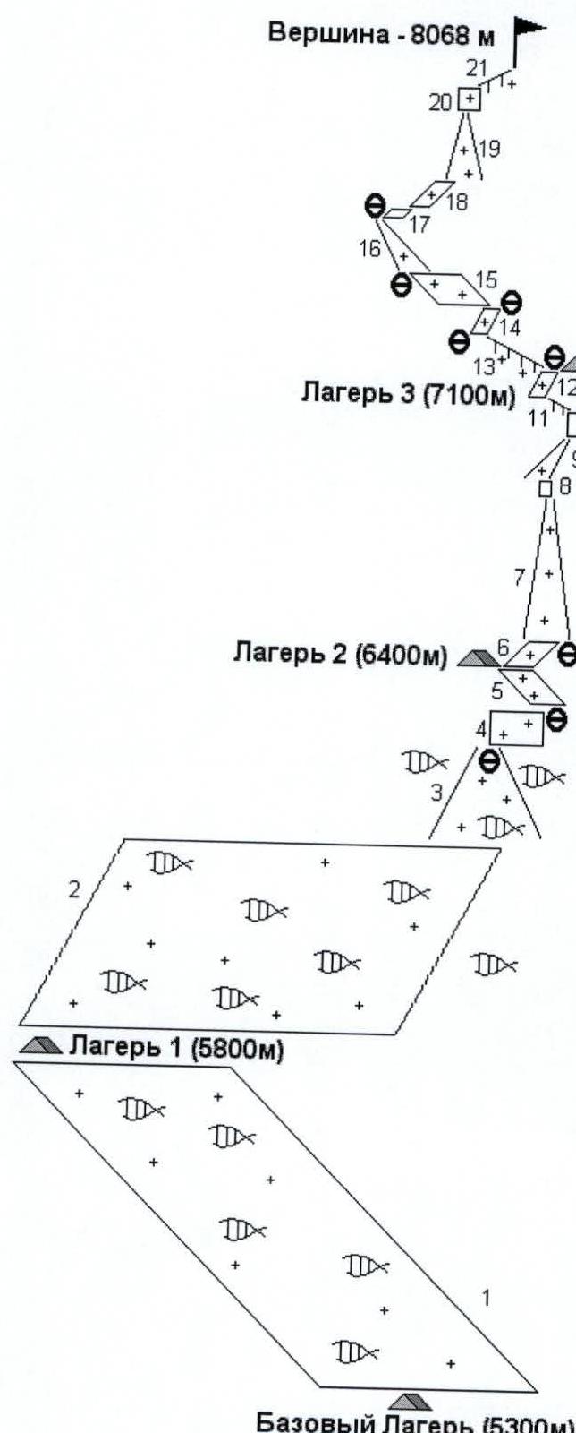
| № | Steepness | Length | Difficulty | Pitons | ||
|---|---|---|---|---|---|---|
| Rock | Ice | Snow | ||||
| 1 | 30° | 4500 m | I | 3 | 2 | |
| 2 | 15° | 3000 m | I | |||
| 3 | 40° | 800 m | II | |||
| 4 | 75° | 50 m | III | 2 | 3 | |
| 5 | 30° | 300 m | II | |||
| 6 | 40° | 300 m | I | |||
| 7 | 60° | 500 m | III | 4 | 4 | |
| 8 | 80° | 10 m | V | 4 | ||
| 9 | 50° | 300 m | IV | 5 | 1 | |
| 10 | 75° | 70 m | V | 4 | ||
| 11 | 30° | 100 m | II | 1 | ||
| 12 | 60° | 200 m | II | 1 | 1 | |
| 13 | 30° | 150 m | I | |||
| 14 | 50° | 150 m | III | 1 | ||
| 15 | 30° | 500 m | I | |||
| 16 | 45° | 400 m | III | 6 | ||
| 17 | 40° | 50 m | II | |||
| 18 | 40° | 100 m | III | |||
| 19 | 45° | 400 m | III | |||
| 20 | 70° | 100 m | IV | 2 | ||
| 21 | 30° | 100 m | II | 1 |
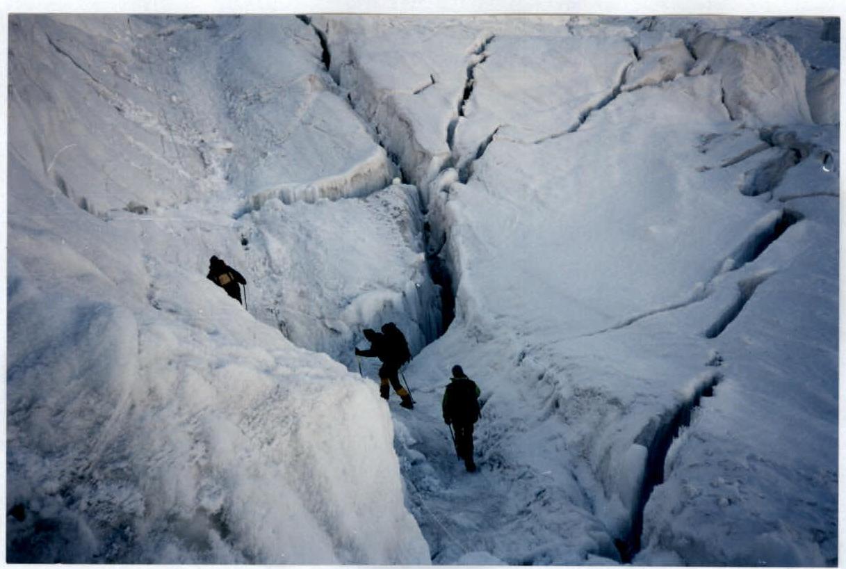
Path in the icefall (5500 m) on the way to Camp 1 — Uryubko D., Lavrov S., Molgachev D. Section R1
Ascent through the icefall to Camp 2. Height — 6200 m. Section R3
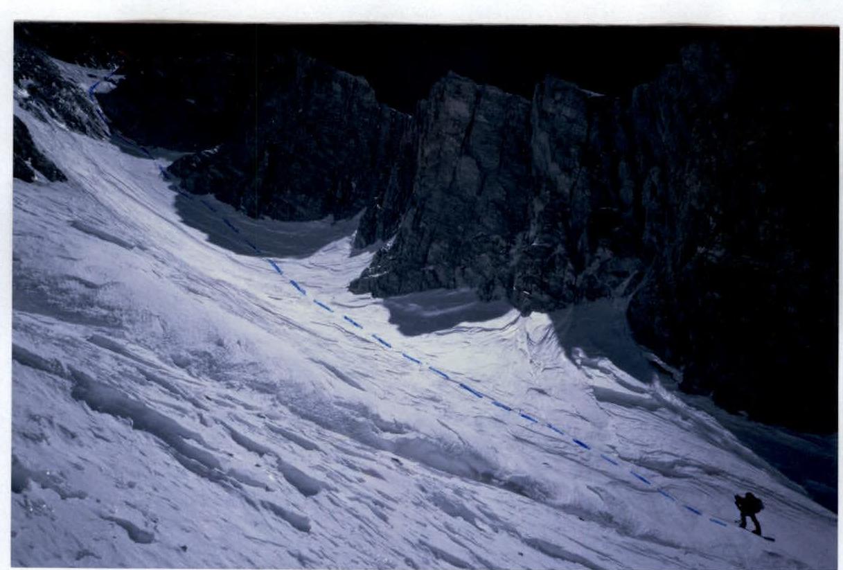
"Japanese" couloir (6500 m — 7100 m) — path from Camp 2 to Camp 3. Section R7
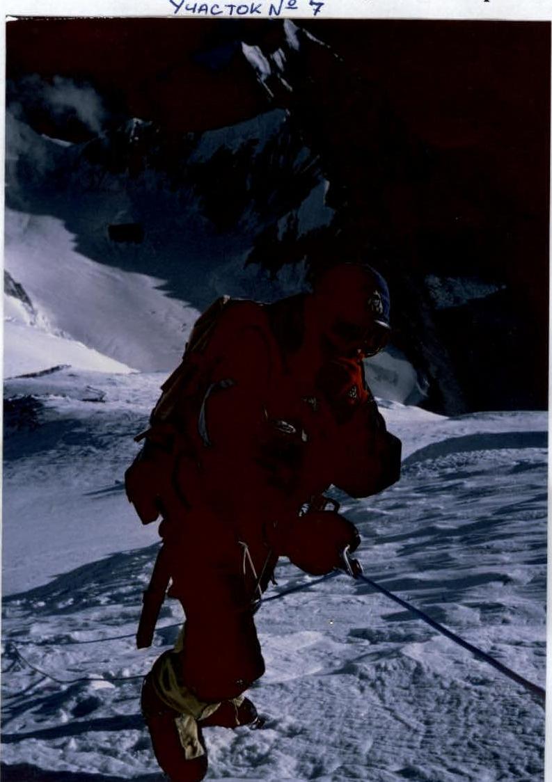
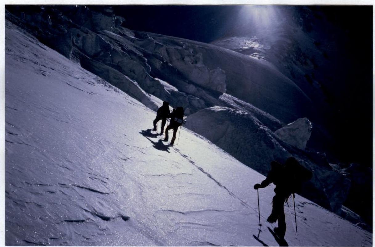
On the route above Camp 3. Beginning of the ascent from the Firn plateau. Height 7350 m
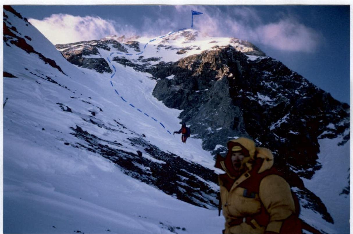
View of the route above the Firn plateau to the summit — from 7300 m to 8086 m. Sections R16–R21
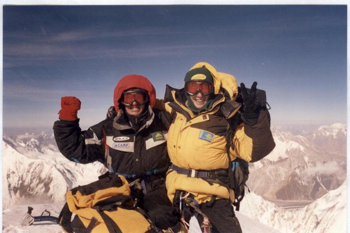
Uryubko D. and Zhumaev M. on the summit of Hidden Peak (8068 m).
Comments
Sign in to leave a comment