Ascent Passport
- Ascent area — Himalayas, Manaslu area, Lidannda gorge.
- Peak P-2, height 6251 m, via SE ridge
- Proposed — 6A cat. dif., first ascent
- Route character: combined.
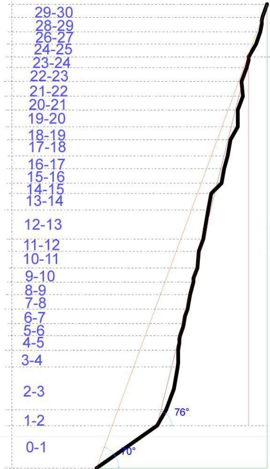
- Route elevation gain: 1254 m (by altimeter)
Route length: 1485 m. Length of sections: V cat. dif. — 385 m, VI cat. dif. — 350 m. Average steepness: main part of the route — 76°, total route — 70°.
-
"Hooks" left on the route: total — 4; incl. bolted — 0. Hooks used on the route: 96, incl. artificial aids — 13 Placement elements used: 129, incl. artificial aids — 16 Ice screws used: 29
- stationary bolted — 0, incl. artificial aids — 0
- removable bolted — 0, incl. artificial aids — 0 Total artificial protection points (artificial aids) used: 29
-
Team's climbing hours: 45 h, 5 days
-
Leader: Bublik Sergey Yuryevich, MSMSK
Participants:
- Shimko Nikolay Nikolayevich, CMS
-
Coach: Self-coached
-
Departure to the route: 4:30, October 19, 2012 Summit reached: 11:30, October 23, 2012 Return to Base Camp: 21:15, October 23, 2012 Overall photo of the summit
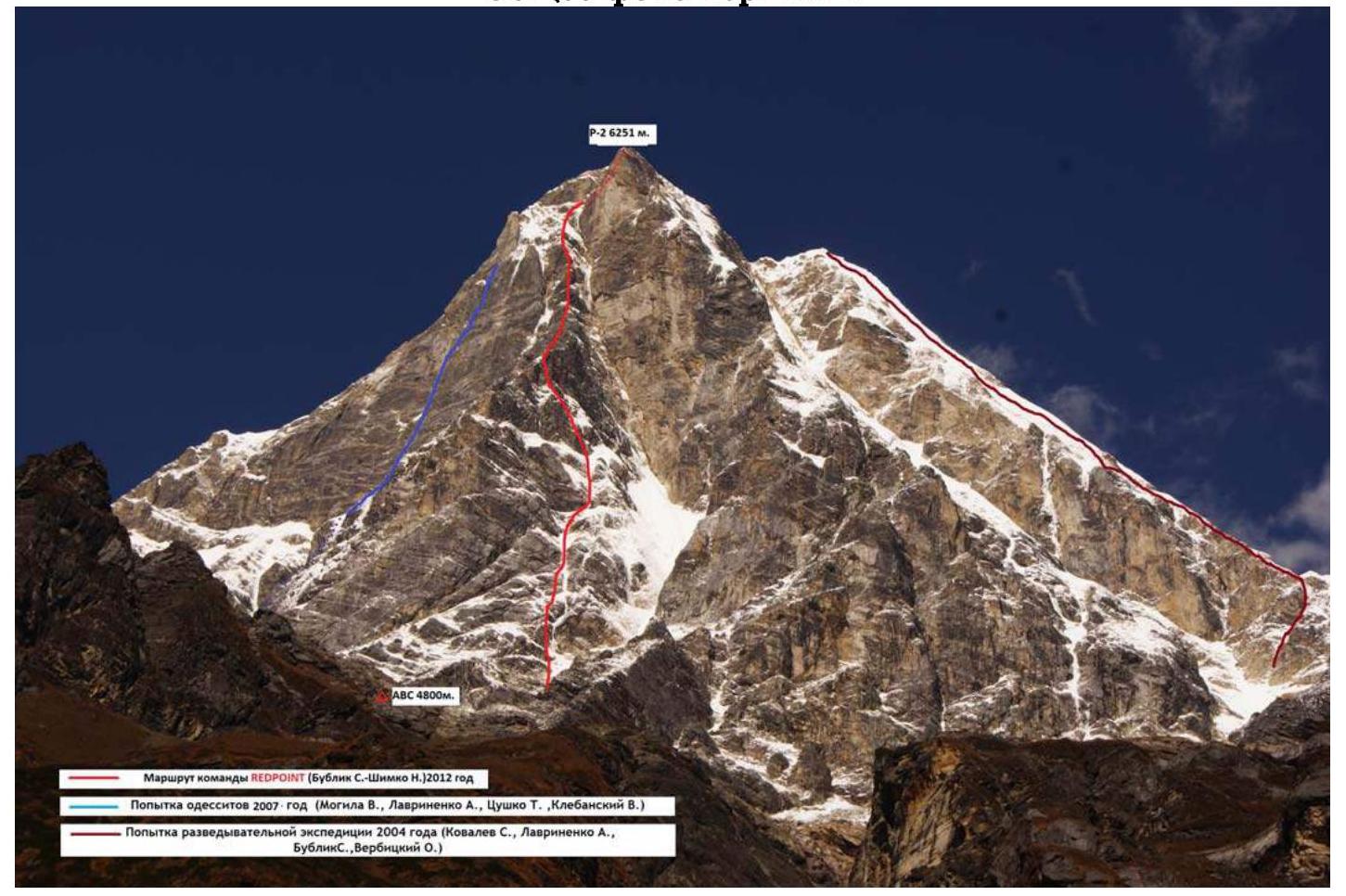
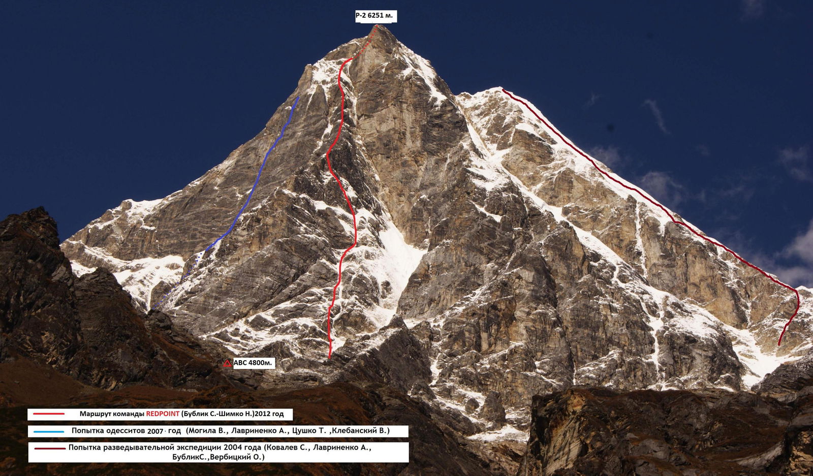
REDPOINT team route (Bublik S. — Shimko N.), 2012
Odessites' attempt in 2007:
- Moguila V.
- Lavrinenko A.
- Tsushko T.
- Klebansky V.
Reconnaissance expedition attempt in 2004:
- Kovalev S.
- Lavrinenko A.
- Bublik S.
- Verbitsky O.
Summit October 23, 2012, 11:30
| October 23, 2012 | |
|---|---|
| October 21, 2012 | |
| October 20, 2012 | |
| October 19, 2012 |
October 19 – R0–R1. From the bivouac under the wall, approach the base of the large couloir. Up the snowy couloir at 35° for 200 m, staying on its right side. Avalanches come down the couloir! 200 m, 35°, III.
R1–R2. Turn left from the couloir and go straight up the ice-snow slope at 45–60° along the ice-rock boundary towards the ice "rivulet" with steepness up to 90°. 50 m, 60°, IV–V (W12).
R2–R3. Bypass the ice "rivulet" on the left via mixed terrain to the wall with the ice "rivulet". 120 m, 70–80°, V (M4).
R3–R4. Enter the ice "rivulet": mixed terrain 10 m — M5, 85°; then a hissing ice icicle with very thin ice, insurance organization is problematic W16, 85–90°, 35 m. 45 m, 90°, VI+.
R4–R5. Further up the ice "rivulet" at 70–80°, overcoming an ice step 10 m, 90°, insurance organization is problematic. 40 m, 90°, V (W15).
R5–R6. Move towards the rock wall along a steep firn couloir, insurance organization is problematic. There's a good spot for a bivouac here. 70–80°, IV+ (W13), 35 m. October 20 – R6–R7. From the bivouac, move up the mixed section 20 m, M6, 80°; insurance is provided by medium-sized anchor hooks, then an ice section 25 m, W14, 70–85°. 70–85°, V+, 40 m.
R7–R8. Move along thin, formed ice, ice screws enter less than halfway. Station under a 4-meter overhang. 80–85°, VI (W15), 40 m.
R8–R9. Move along the firn slope towards the rock ridge. 75°, IV (W13), 35 m. R9–R10. From the station, straight up a complex mixed section 10 m, VI (M6), 90°, then up and to the right along the ice slope to approach the base of a large rock bastion W13, 70°, 30 m. 70–90°, IV–VI, 40 m.
R10–R11. Further up complex rocks with mixed sections. 85°, VI (6c(+), M6) 45 m. R11–R12. Move towards the large couloir along mixed terrain. 70°, IV (M4), 35 m. R12–R13. Move up the couloir with steep, thin, formed ice towards the rocks. Safe spot for a bivouac. 80–85°, V+ (W15–16), 80 m. October 21 – R13–R14. From the bivouac, move up and to the left along a complex mixed section. 80–90°, VI (M6), 40 m.
R14–R15. Move up a snow slope of medium steepness 10 m to a sharp ridge, then along the ridge towards the bastion. 45°, IV+, 40 m.
R15–R16. Further up, climbing an internal corner with a small number of artificial aids A1, towards a snow ledge. 80°, VI, 40 m.
R16–R17. Approach the rock bastion along the snow. Climb the bastion straight up. Insurance organization is problematic. 75°, V+, 35 m.
R17–R18. Then, up an internal corner with a crevice, exiting onto steep "ram's foreheads", insurance is problematic, provided using anchor hooks. 80°, VI(A2), 45 m.
R18–R19. Further along the ice slope with rock walls to approach the rock wall. Spot for an overnight stay. 60°, IV+, 40 m. October 22 – R19–R20. From the bivouac, move left along the ledge 8 m to the base of a dead-end crevice, up the crevice using artificial aids with complex belays (possibly free climbing, estimated difficulty 7b/7c). 85–90°, VI+ (A3, 6c), 45 m.
R20–R21. Climbing rocks with mixed sections. 70°, IV+ (5b, M3), 40 m.
R21–R22. Straight up complex rocks, lower part 20 m, passed using complex artificial aids (A3), then complex climbing (6c) to a flattening (possibly free climbing, estimated difficulty 7c (+)). 95°, VI (A3, 6c), 40 m.
R22–R23. Move along ice-mixed terrain towards an internal corner. 70°, IV (M4), 40 m.
R23–R24. Rock-mixed section. Exit to the ice slope via an internal corner. 75–90°, VI (M4, A2), 30 m.
R24–R25. Move along the snow slope towards the summit. 60°, IV, 40 m.
R25–R26. From the summit couloir, traverse left along the snow slope to the overnight stay spot, located under an overhang. 60°, III, 50 m. October 23 – R26–R27. Ice-mixed section 70°, IV (W13), M4, 35 m.
R27–R28. Traverse right along rocks of medium complexity towards the couloir. 70°, IV, 40 m. R28–R29. Move up the ice couloir straight up, overcoming steps with steepness up to 90°. 80°, V+ (W15), 40 m.
R29–R30. Up the couloir to the summit. 70°, IV (W13), 40 m.
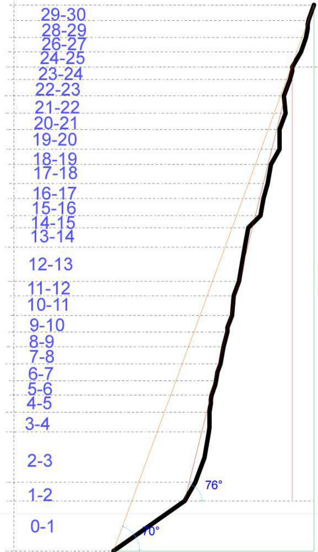
Route sections
- R29–R30
- R28–R29
- R26–R27
- R24–R25
- R23–R24
- R22–R23
- R21–R22
- R20–R21
- R19–R20
- R18–R19
- R17–R18
- R16–R17
- R15–R16
- R14–R15
- R13–R14
- R12–R13
- R11–R12
- R10–R11
- R9–R10
- R8–R9
- R7–R8
- R6–R7
- R5–R6
- R4–R5
- R3–R4
- R2–R3
- R1–R2
- R0–R1
| Hooks | Scheme in UIAA symbols | Section | Length m | Steepness ° | Cat. dif. | |||
|---|---|---|---|---|---|---|---|---|
| Rock | Ice | Plac. | Bolt | sheet 1 | ||||
| 3 | 3 | 2 | --- | R4–R5 | 40 | 70–90 | V | |
| 3 | 4 | 3 | --- | R3–R4 | 45 | 90 | VI | |
| 9 | --- | 10 | --- | R2–R3 | 120 | 70–80 | V | |
| 1 | 2 | 3 | --- | R1–R2 | 50 | 45–60 | IV | |
| ---- | ---- | ---- | --- | R0–R1 | 200 | 35 | III |
| Hooks | Scheme in UIAA symbols | Section | Length m | Steepness ° | Cat. dif. | |||
|---|---|---|---|---|---|---|---|---|
| Rock | Ice | Plac. | Bolt | sheet 2 | ||||
| 1 | --- | 2 | --- |  | R14–R15 | 40 | 45 | IV+ |
| 5 | --- | 6 | --- | R13–R14 | 40 | 80–90 | VI | |
| 6 | 2 | 8 | --- | R12–R13 | 80 | 80 | V+ | |
| 4 | 2 | 4 | --- | R11–R12 | 35 | 70 | IV | |
| 6 | --- | 6 | --- | R10–R11 | 45 | 85 | VI | |
| 4 | 1 | 5 | --- | R9–R10 | 40 | 70–90 | V–VI | |
| 2 | 1 | 2 | --- | R8–R9 | 35 | 75 | IV | |
| 4 | 2 | 5 | --- | R7–R8 | 40 | 80–85 | VI | |
| 3 | 2 | 4 | ---- | R6–R7 | 40 | 70–85 | V+ | |
| 3 | 2 | 3 | --- | R5–R6 | 35 | 70–80 | IV+ |
| Hooks | Scheme in UIAA symbols | Section | Length m | Steepness ° | Cat. dif. | |||
|---|---|---|---|---|---|---|---|---|
| Rock | Ice | Plac. | Bolt | sheet 3 | ||||
| 2 | 1 | 1 | --- | R25–R26 | 50 | 60 | III | |
| 1 | 2 | 2 | --- | R24–R25 | 40 | 60 | IV | |
| 3/2 | 1 | 4/1 | --- | R23–R24 | 30 | 80 | V+ | |
| 2 | --- | 5 | --- | R22–R23 | 40 | 70 | IV | |
| 6/4 | --- | 8/5 | --- | R21–R22 | 40 | 95 | VI+ | |
| 3 | --- | 4 | --- | R20–R21 | 40 | 70 | IV+ | |
| 5/3 | --- | 8/4 | --- | R19–R20 | 45 | 85 | VI+ | |
| 2 | --- | 4 | --- | R18–R19 | 40 | 60 | IV+ | |
| 5/3 | --- | 8/4 | --- | R17–R18 | 45 | 80 | VI+ | |
| 3 | --- | 6 | --- | R16–R17 | 35 | 75 | V+ | |
| 4/1 | --- | 6/2 | --- | R15–R16 | 40 | 80 | VI |
| Hooks | Scheme in UIAA symbols | Section | Length m | Steepness ° | Cat. dif. | |||
|---|---|---|---|---|---|---|---|---|
| Rock | Ice | Plac. | Bolt | sheet 4 | ||||
| 1 | 1 | 2 | --- | R29–R30 | 40 | 70 | IV | |
| 2 | 2 | 2 | --- | R28–R29 | 40 | 80 | V+ | |
| 2 | --- | 4 | ---- | R27–R28 | 40 | 70 | IV | |
| 1 | 1 | 2 | --- | R26–R27 | 35 | 70 | IV |