
Report
On the First Ascent to the Summit
Mt. Taunga (Sikhote-Alin Ridge)
Via the central ridge of the northern slope, 2A category of complexity (winter, snow-ice) by the team of Khabarovsk Regional Public Organization "Khabarovsk Regional Alpine Federation"
November 5, 2016
I. Ascent Passport
| № | 1. General Information | |
|---|---|---|
| 1.1 | Full name, sports rank of the leader | Kurdyukov Vasily Vladimirovich, instr. №197 |
| 1.2 | Full name, sports rank of participants | Donskov Andrey Mikhailovich, 1st sports rank, Gorokhov Kirill Gennadievich, no rank, Chekmareva Evgeniya Borisovna, no rank |
| 1.3 | Full name of the coach | Krasnolutsky Alexander Vyacheslavovich, CMS, instr. №606 |
| 1.4 | Organization | Khabarovsk Regional Public Organization "Khabarovsk Regional Alpine Federation" |
| 2. Characteristics of the Ascent Object | ||
| 2.1 | Region | Khabarovsk Krai; Sikhote-Alin Ridge. The summit of the mountain is on the administrative border of Nanaisky and Vaninsky municipal districts. |
| 2.2 | Valley | Taunga stream valley (tributary of the Gobbili River) |
| 2.3 | Section number according to the 2013 classification table | 9.9 |
| 2.4 | Name and height of the summit | Mt. Taunga, 1459 m above sea level |
| 2.5 | Geographical coordinates of the summit (by GPS) | 49°14′01″ N, 138°43′56″ E |
| 3. Characteristics of the Route | ||
| 3.1 | Route name | Via the central ridge of the northern slope |
| 3.2 | Proposed category of complexity | 2A (winter, snow-ice). In summer, it is not an alpine object due to dense dwarf pine on the slopes, which are under snow in winter. |
| 3.3 | Degree of route development | First ascent; date of the first ascent unknown |
| 3.4 | Relief characteristics of the route | Snow-firn slope with an exit to a wide snow ridge |
| 3.5 | Height difference of the route (by GPS) | 285 m |
| 3.6 | Route length | 930 m |
| 3.7 | Technical elements of the route, length of sections of varying complexity with relief characteristics | 1st category – 50 m, snow-firn slope, 2nd category – 390 m, snow-firn slope, 3rd category – 200 m, snow-firn slope |
| 3.8 | Descent from the summit | Non-categorized, via the left spur of the summit |
| 3.9 | Additional route characteristics | Approach to the start of the route is about 2–2.5 km through a forest without trails, turning into a forested gorge with an exit to a forested spur. The start of the route is from the exit to the unforested slope. |
| 4. Characteristics of the Team's Actions | ||
| 4.1 | Time of movement (team's working hours, indicated in hours and days) | 7.5 hours, including approach to the route 1.5 hours, ascent 4 hours, descent and return 1.5 hours |
| 4.2 | Overnights | - |
| 4.3 | Start of the route | 8:00 on November 5, 2016, start of work on the route at 9:35 |
| 4.4 | Reaching the summit | 13:25 on November 5, 2016 |
| 4.5 | Return to the base camp | 15:10 on November 5, 2016 |
| 5. Responsible for the Report | ||
| 5.1 | Full name, e-mail | Gorokhov Kirill Gennadievich, gokigenn@mail.ru |
II. Description of the Ascent
1. Characteristics of the Ascent Object
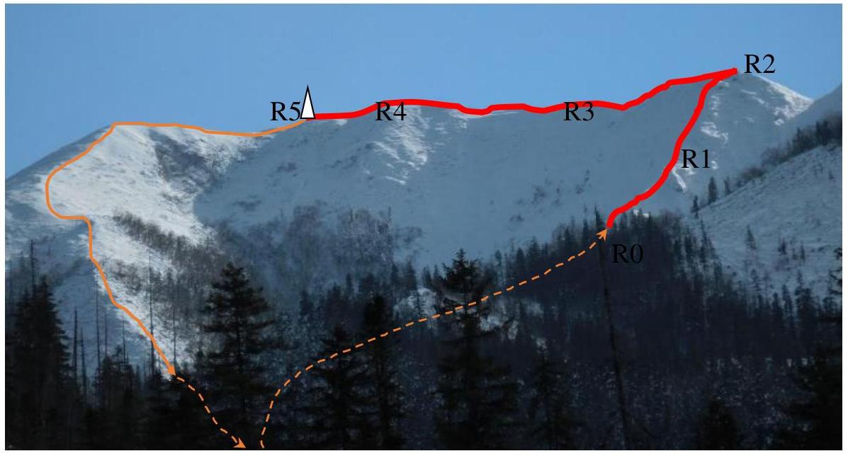
1.1. General Photo of the Summit
- route line
- approach and descent lines
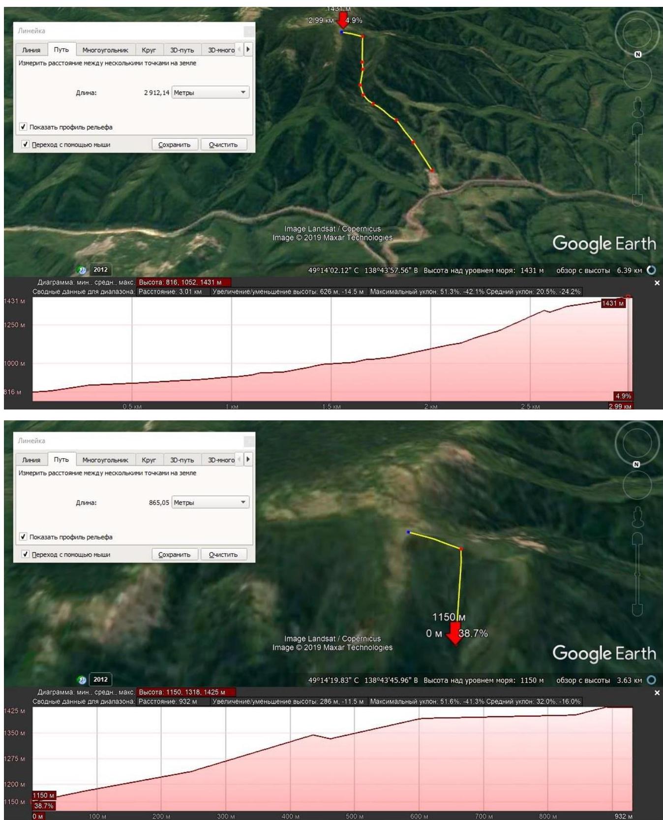
1.2. Photo of the Route Profile
The report includes route profiles with characteristics compiled in Google Earth. The first profile includes the approach to the route, and the second is the ascent route itself, without approaches.
1.3. Cartographic Materials
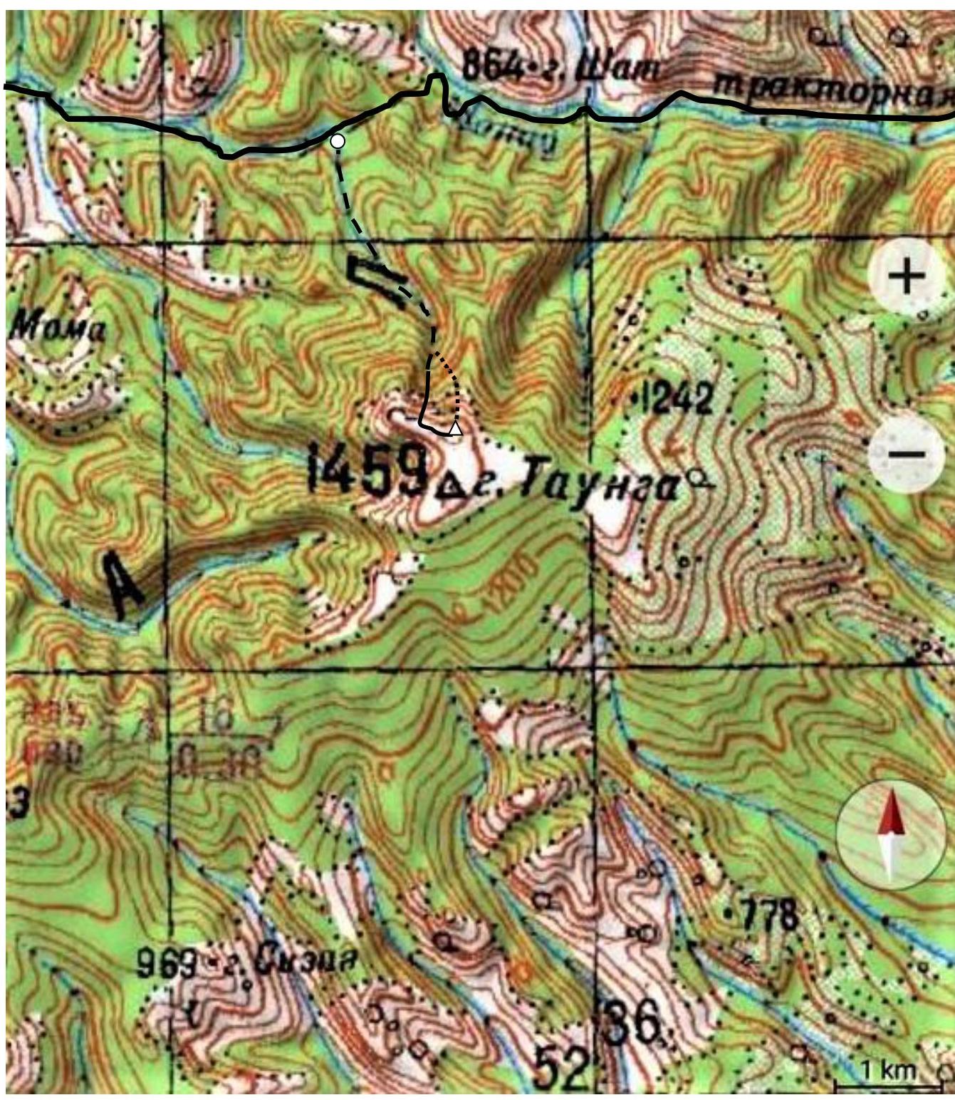
1.4. Description of the Area. Approach to the Route
The mountain is located near the pass through the Sikhote-Alin Ridge on the Lidoga-Vanino highway, in its middle part. There are no categorized summits or passes in the area as of the report date. The summit is about 3 km from the highway in a straight line.
The approach starts from the abandoned settlement of road builders (about 785 m above sea level) at the 178th km of the highway (from Lidoga settlement), i.e., about 400 km from the regional center, Khabarovsk.
The approach (marked with a dashed line on the map) is about 500 m through the abandoned settlement, then about 2–2.5 km (depending on the chosen path) without trails through the forest along the Taunga stream (tributary of the Gobbili River). Gradually, the stream valley turns into a forested gorge, dividing into separate gullies. Choosing the central ridge running down into the valley, one should continue along it. местами, the forest grows on slopes with an angle of 40–50°, which, with a large amount of snow (snow cover can reach up to 1.5 m deep) and the impossibility of using snowshoes on the slope, can cause difficulties in moving through the forest and may require the installation of auxiliary ropes.
The start of the route (marked with a solid line on the map) is the exit from the forest to the unforested ridge. Exiting to the start of the route through the side gullies is not recommended due to their high avalanche danger.
The descent from the route (marked with a dotted line) is done via the lateral (left relative to the ascent line) spur.
To the south of the route, a lateral summit of the massif is visible, slightly higher than the objective and not representing a technical difficulty. It is not included in the ascent route. On the map, it is marked as the main summit. However, the summit sign is located on the ascent objective, representing a standalone, pronounced summit; it is an antenna stand previously used for radio communication between the temporary settlement of road builders and Vanino settlement.
2. Characteristics of the Route
2.1. General Photograph is presented in Section 1.1.
- route line
- approach and descent lines
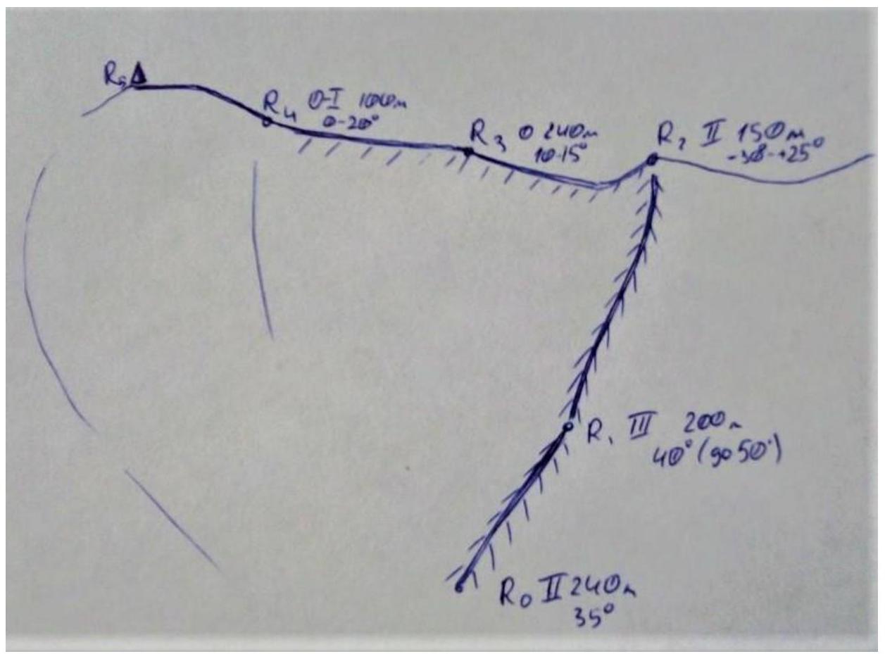
2.2. Technical Characteristics of Route Sections
| Section № | Relief Characteristics | Category of Complexity | Length, m | Type and Number of Pitsons |
|---|---|---|---|---|
| R0–R1 | Snowy slope, sometimes dense from snowdrifts; sometimes feet sink into dwarf pine under the snow. Average angle 30–35°. | 2 | 240 | Simultaneous movement in a rope team |
| R1–R2 | Movement along a pronounced, not sharp ridge. Dense firn, sometimes with small, up to 3–4 m, ledges (risk of falling!). Average angle 40° (up to 50° in the upper part). Exit to an intermediate summit (about 1350 m above sea level) to the left of an avalanche chute with rockfalls in the upper part (landmark in poor visibility). | 3 | 200 | Mainly alternate, sometimes simultaneous movement in a rope team. Belaying via ice axe. |
| R2–R3 | Movement to the left (SW-3) along the ridge with a descent from the intermediate summit (–10 m, –30°) and ascent to the broad shoulder of the main summit (+60 m, average angle 25° (up to 40° in some areas)). Possible formation of snowdrifts and "flags"! Movement in a rope team. Belaying via ice axe. Mainly simultaneous, sometimes alternate. | 2 | 150 (20+130) | Mainly simultaneous, sometimes alternate |
| R3–R4 | Wide T-ridge leading to the summit. 10–15°. | 0 | 240 | Simultaneous movement |
| R4–R5 | Ascent along a broad slope to a wide summit to the stand of an old unused antenna, first upwards (average angle 20°, category 1), then without gaining height. The summit is blown clear of snow by the wind. | 0–1 | 100 (50+50) | Simultaneous movement |
3. Characteristics of the Team's Actions
3.1. Brief Description of the Route Passage.
| Section № | Description | Photo Number |
|---|---|---|
| R0–R1 | Snowy slope, sometimes dense from snowdrifts; sometimes feet sink into dwarf pine under the snow. Average angle 30–35°. Simultaneous movement in a rope team. | Photo 1 |
| R1–R2 | Movement along a pronounced, not sharp ridge. Dense firn, sometimes with small, up to 3–4 m, ledges (risk of falling!). Mainly alternate, sometimes simultaneous movement in a rope team. Firn is very dense. Belaying via ice axe (Photo 2). Exit to an intermediate summit (about 1350 m above sea level) to the left of an avalanche chute with rockfalls in the upper part (landmark in poor visibility; Photo 3). | Photo 2, Photo 3 |
| R2–R3 | Movement to the left (SW-3) along the ridge with a descent from the intermediate summit (–10 m, –30°, Photo 4) and ascent to the broad shoulder of the main summit (+60 m, average angle 25° (up to 40° in some areas)). Mainly simultaneous, sometimes alternate movement in a rope team. Firn is very dense. Belaying via ice axe. Possible formation of snowdrifts and "flags"! General view of the section – Photo 5 (taken during the ascent R1–R2). | Photo 4, Photo 5 |
| R3–R4 | Wide T-ridge leading to the summit. 10–15°. Simultaneous movement. | Photo 5 |
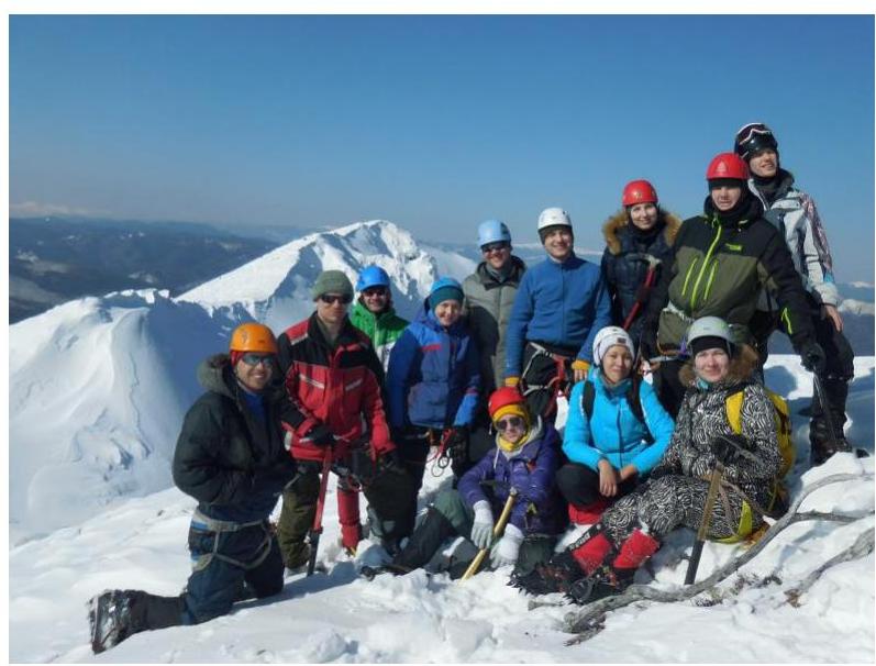
| R4–R5 | Ascent along a broad slope to a wide summit, first upwards (average angle 20°), then without gaining height. Photo of ascent participants along with a group of tourists who ascended the summit independently. | Photo 6 |
Photo 1
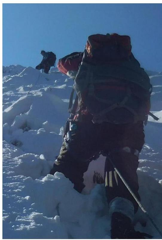
Photo 2
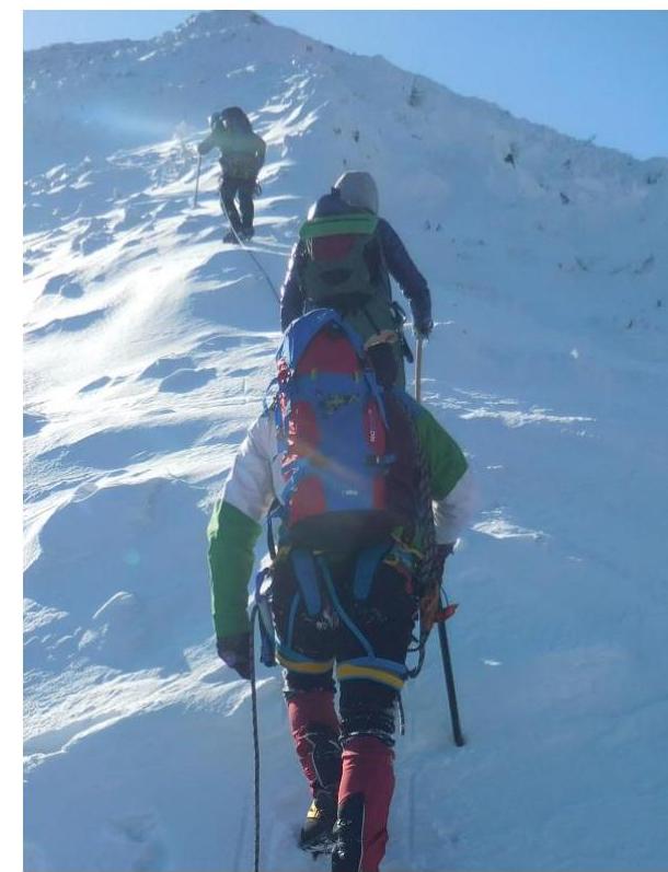
Photo 3
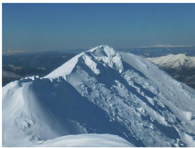
Photo 4
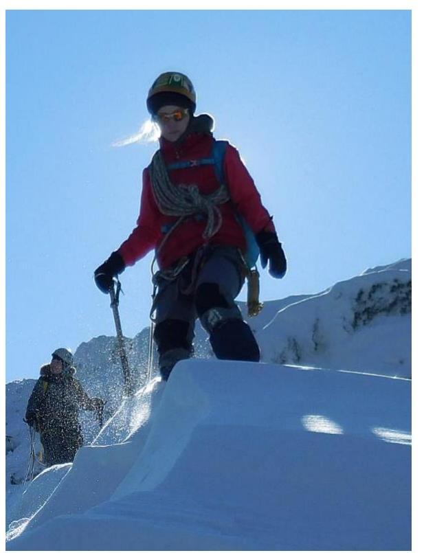
Photo 5
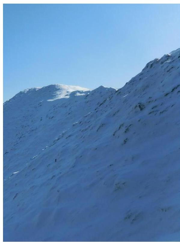
Photo 6
3.2. Safety Assessment of the Route. Options for Communication on the Route. Recommendations for Future Climbers.
Recommended ascent period: second half of November – first half of March.
Overall, the route is not complicated, logical, and fairly safe if one exits to the ridge through the forest in time, avoiding the avalanche-prone gullies on the sides of the ridge. It is recommended to ascend the route only with a stable snow cover.
One should be careful in February–March on section R1–R2 (3rd category), when the snow becomes so dense that the ice axe pick sometimes does not penetrate the firn, and one has to work with the beak of the tool (as experienced during the ascent on March 4, 2019), increasing the risk of participants slipping on the slope.
Descent from the summit is recommended along the gentle left slope (relative to the ascent line) with an exit to the gully where the ascent to the route was made.
With fresh snow, it is recommended to use snowshoes on the approaches.
Comments
Sign in to leave a comment