Report on the First Ascent to the Peak Maly Zub via the Taijesu Pass Route, Category 1B, by the Kemerovo Region Alpine Federation Team on March 2, 2020
I. Ascent Passport
| № | 1. General Information | |
|---|---|---|
| 1.1 | Full Name, Sports Rank of the Leader | Anikin Alexander Efimovich, 1st sports rank, Instructor Category III (Certificate № 1919) |
| 1.2 | Full Name, Sports Rank of the Participants | Tomilov Anatoly Grigorievich, 1st sports rank; Timofeev Nikolay Viktorovich, 1st sports rank; Trashkov Andrey Anatolyevich, 1st sports rank; Rodionov Alexey Valeryevich, 2nd sports rank; Dyakonov Sergey Vasilyevich, 2nd sports rank; Dyakonov Semyon Sergeyevich, 3rd sports rank; Ryabinin Viktor Vladimirovich, 3rd sports rank; Ivashov Evgeny Dmitrievich, 3rd sports rank; Borger Viktor Andreyevich, 3rd sports rank; Sibiryakov Sergey Alexandrovich, badge holder |
| 1.3 | Full Name of the Coach | Tomilov Anatoly Grigorievich |
| 1.4 | Organization | Kemerovo Region Alpine Federation |
| 2. Characteristics of the Ascent Object | ||
| 2.1 | Region | SIBERIA AND FAR EAST MOUNTAINS. Kuznetsky Alatau (Kemerovo Region) |
| 2.2 | Valley | Vysokogorny Stream Valley |
| 2.3 | Section Number according to the 2013 Classification Table | 9.5 |
| 2.4 | Name and Height of the Peak | Maly Zub (1,983 m above sea level) |
| 2.5 | Geographical Coordinates of the Peak (Latitude/Longitude), GPS Coordinates | Latitude 53.790853° Longitude 89.120369° |
| 3. Characteristics of the Route | ||
| 3.1 | Route Name | via Taijesu Pass |
| 3.2 | Proposed Category of Complexity | 1B |
| 3.3 | Degree of Route Development | First Ascent |
| 3.4 | Relief Characteristics of the Route | Combined |
| 3.5 | Height Difference of the Route (altimeter or GPS data) | 179 m (from Taijesu Pass) |
| 3.6 | Route Length (in meters) | 1,000 m (from Taijesu Pass) |
| 3.7 | Technical Elements of the Route (total length of sections of various complexity categories, indicating relief type (ice-snow, rock)) | Category 1, combination — 940 m. Category 2, rock — 55 m. Category 3, rock — 5 m. Rappelling (during ascent) — 1 rope, 2 m. Rappelling (during descent) — 1 rope, 15 m |
| 3.8 | Descent from the Summit | Via the ascent route to Taijesu Pass |
| 3.9 | Additional Route Characteristics | Lack of water |
| 4. Characteristics of the Team's Actions | ||
| :--: | :--: | :--: |
| 4.1 | Movement Time (team's walking hours, in hours and days) | 1 day, 12 hours |
| 4.2 | Overnight Stays | No |
| 4.3 | Route Entry | 06:20, March 2, 2020 |
| 4.4 | Summit Ascent | 13:50, March 2, 2020 |
| 4.5 | Return to Base Camp | 18:20, March 2, 2020 |
| 5. Responsible for the Report | ||
| 5.1 | Full Name, e-mail | Anikin Alexander Efimovich, anikin1985@rambler.ru |
II. Ascent Description
1. Characteristics of the Ascent Object
1.1. General Photo of the Summit

Photo 1 — Maly Zub summit with the route marked, shot from under Taijesu Pass, March 2, 2020.
1.2. Route Profile Photo
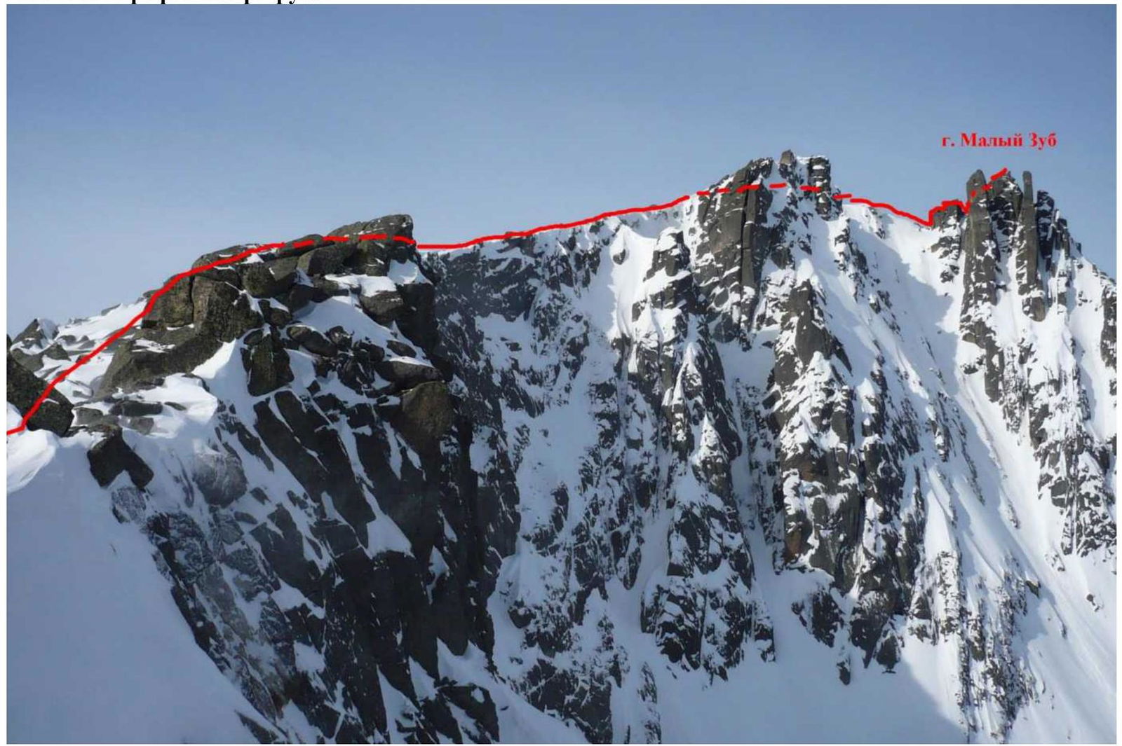
Photo 2 — Route profile, shot from Taijesu Pass, March 2, 2020.
1.3. Panoramic Photo of the Area
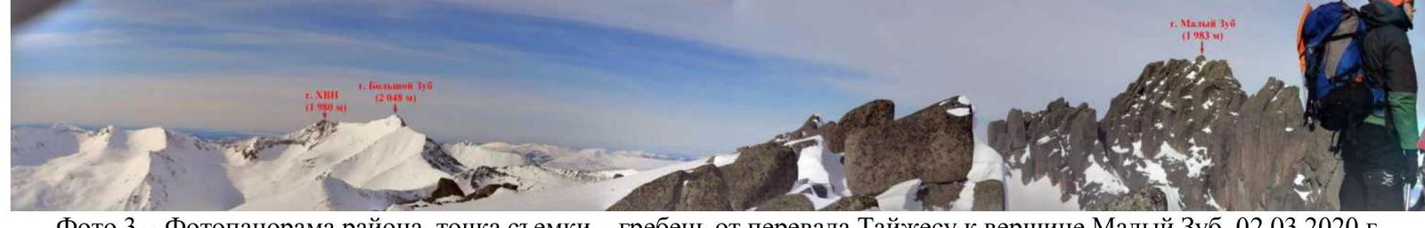
Photo 3 — Panoramic photo of the area, shot from the ridge from Taijesu Pass to Maly Zub summit, March 2, 2020.
1.4. Area Map
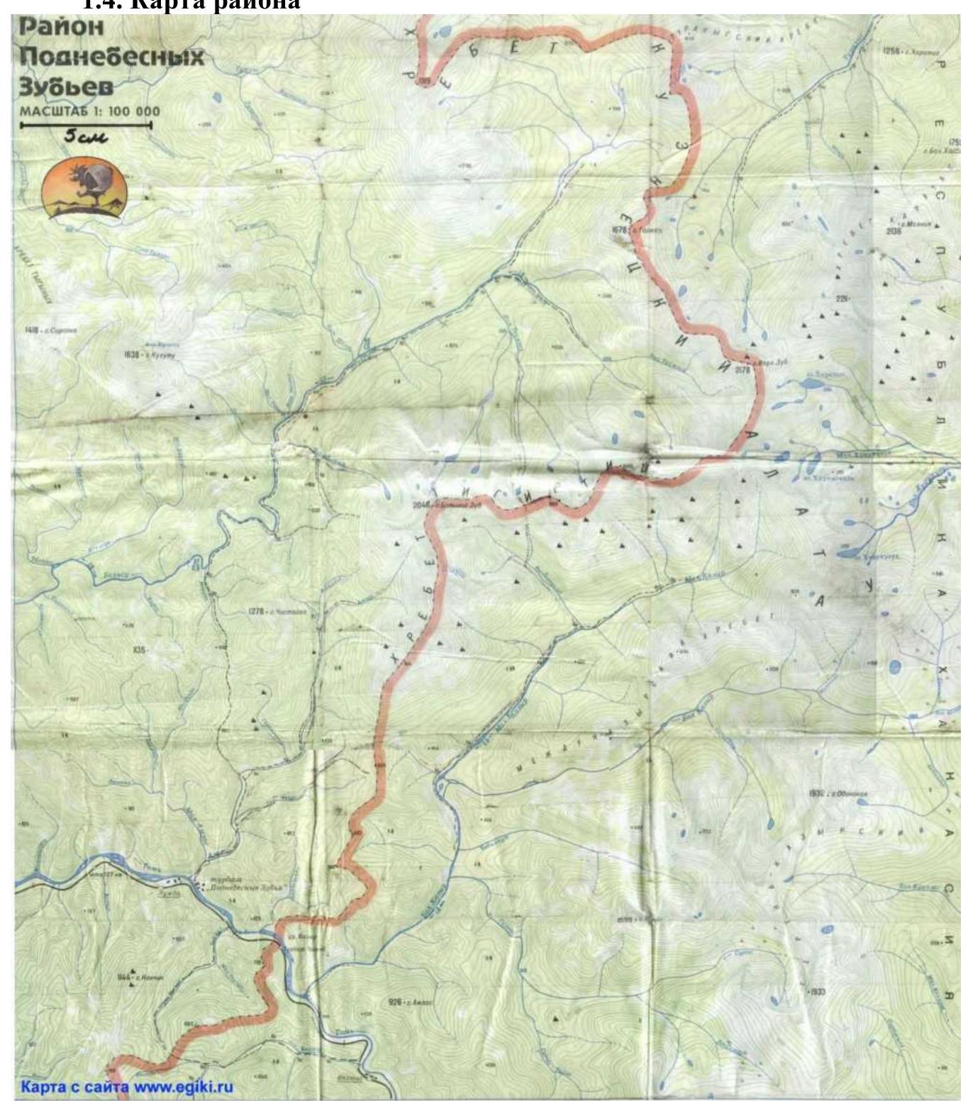
Photo 4 — Area map, scale 1:100,000
Ascent Object Schematic Map
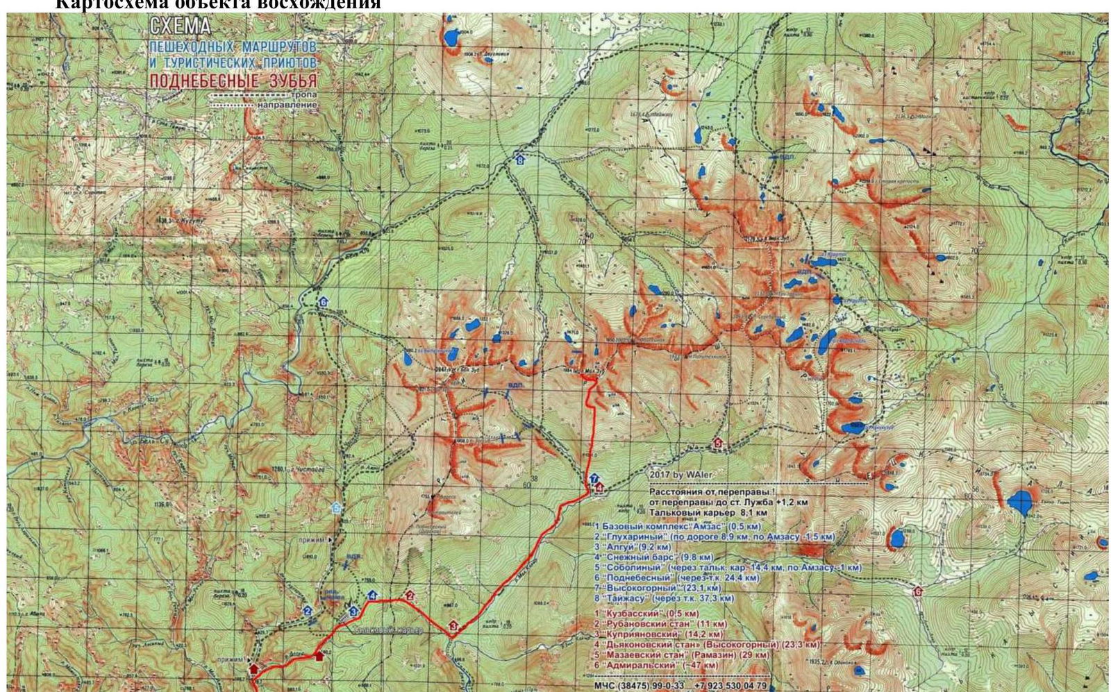
Photo 5 — Schematic map of the approach to Maly Zub summit
Geographical Location and Features of the Area
The Podnebesny Zubye area is located 80 km east of Mezhdurechensk (Kemerovo Region). The most convenient way to arrive is by electric train from Mezhdurechensk station to Luzhba station (1 hour 40 minutes). From Luzhba station, cross the Tom River and move to the Vysokogorny shelter (28 km) (see photo 5). In summer, walk along the road and then along the trail (8-10 hours), in winter, ski (usually along a snowmobile trail) (8-12 hours). In summer, it is possible to drive from the Tom River crossing to the Talkovy quarry by car (8 km). In winter, it is possible to drive from Luzhba station to the Vysokogorny shelter by snowmobile. The Vysokogorny shelter is the most convenient base camp (BC). From BC to the start of the route, move along the southern slope of Maly Zub peak to a characteristic large stone on the left (lower stone in the beginning of the southwest-facing rock ridge). Move to the left side of this rock ridge (western side), then move to Taijesu Pass. In winter, it is most convenient to ski from BC to Taijesu Pass. The approach time from BC to the start of the route (Taijesu Pass) is 4-5 hours. The height difference from BC (504 m above sea level) to Taijesu Pass (1,804 m above sea level) is 1,300 m. The approach path from BC to Taijesu Pass is shown in photos 6-7.
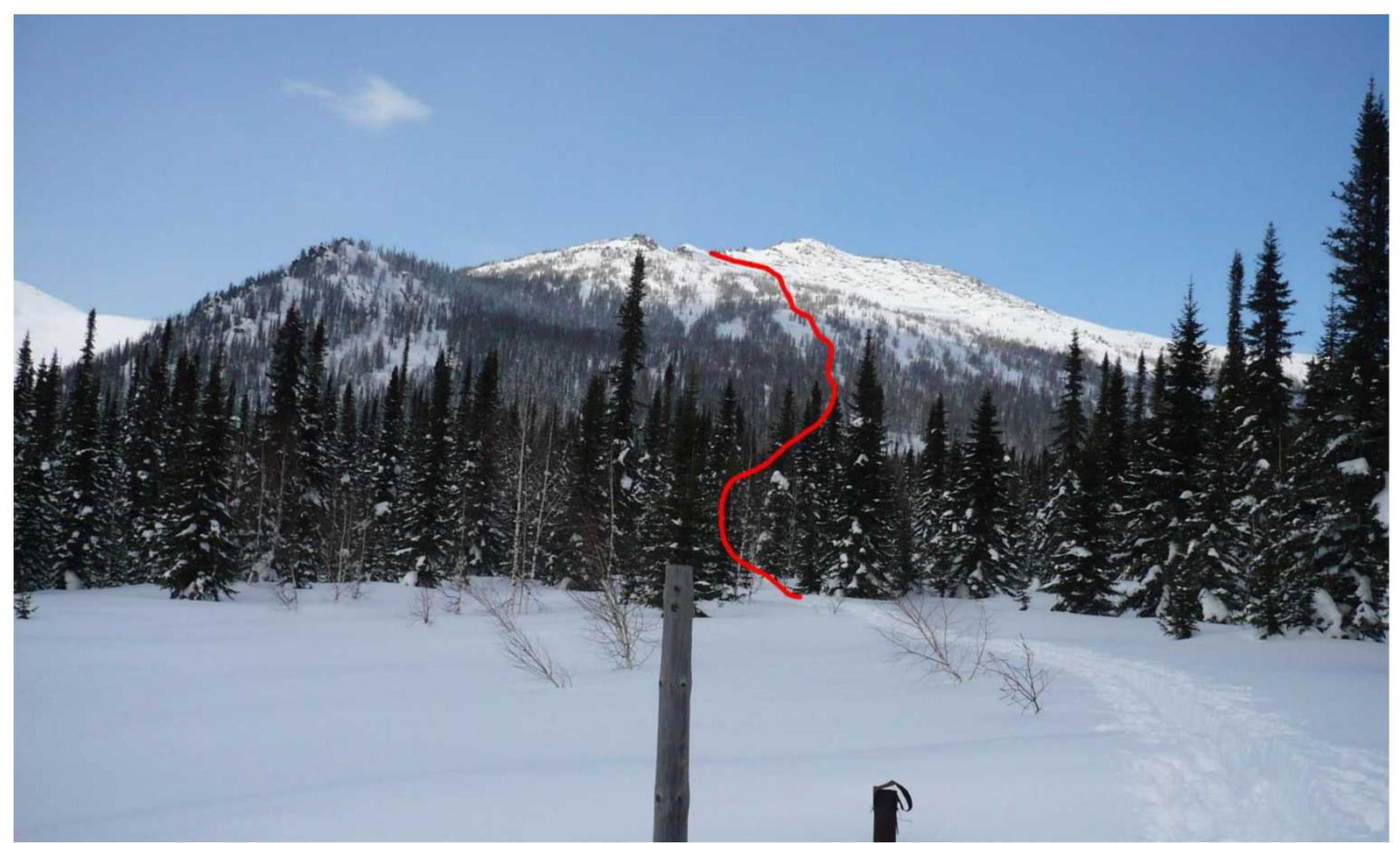
Photo 6 — Approach path from BC to the characteristic large stone on the left (lower stone in the beginning of the southwest-facing rock ridge), shot from Vysokogorny shelter, March 1, 2020.
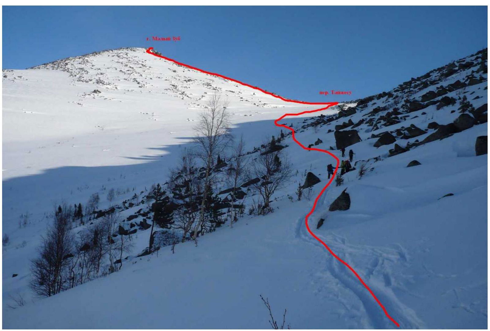
Photo 7 — Approach path from the southwest-facing rock ridge to Taijesu Pass, shot from the western slope of the southwest-facing rock ridge, March 2, 2020.
2. Route Characteristics
2.1. Technical Photo of the Route
![img-7.jpeg]({"width":18