
9.5.9
Climbing Passport
- Kuznetsky Alatau, section 9.5
- Peak "Staraya Krepost'", 2217 m, via the center of the NE wall.
- Proposed 6A winter category of difficulty, first ascent.
- Route type — rock climbing.
- Route height difference — 435 m.
Route length — 460 m. Section lengths:
- Category V — 105 m.
- Category VI — 310 m.
Average steepness — 80°.
- Pitons left on the route: total 12; including 10 bolt pitons.
Pitons used on the route:
- stationary bolt pitons — 10 pcs.;
- removable bolt pitons — 22 pcs., including 22 ITI pitons;
- chocks — 106 pcs.;
- rock pitons — 18 pcs.;
- total artificial aid points — 104 pcs.
- Team's total climbing hours: 50 hours, 8 days.
- Team leader: Vladimir Viktorovich Stalkovsky — Master of Sports
Team members:
- Alexander Valentinovich Belkin — Candidate for Master of Sports
- Nikolay Grigoryevich Kozhemyako — Master of Sports
- Alexander Alexandrovich Tonin — Candidate for Master of Sports
- Yuri Vladimirovich Uteshev — Candidate for Master of Sports
- Coach: Nikolay Grigoryevich Kozhemyako
- Approach to the route — February 21, 2003.
Reached the summit — February 28, 2003. Returned to base camp — February 28, 2003.
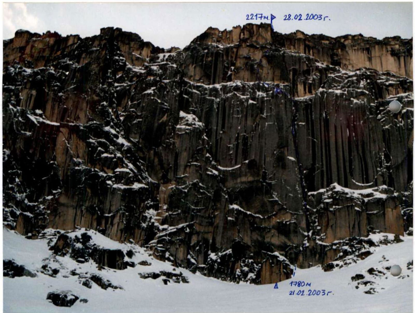
General photo of "Staraya Kreevka" peak. --- Trail passed by the team.
February 21, 2003, photo taken from the circus above the lake.
Sheet 1 Page 2

Photo of the left wall profile. Sections R5–R13 are visible.
Sheet 2 Page 3
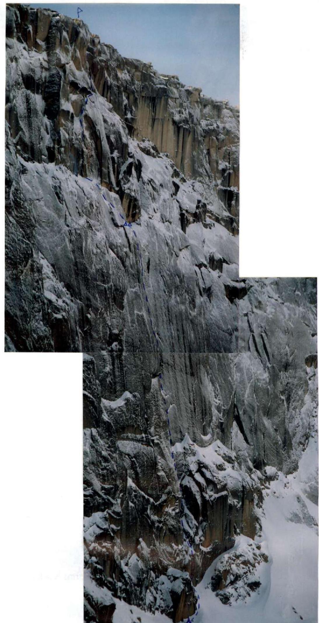
Photo of the right wall profile. Sheet 2 Page 3a Drawn profile of the route.
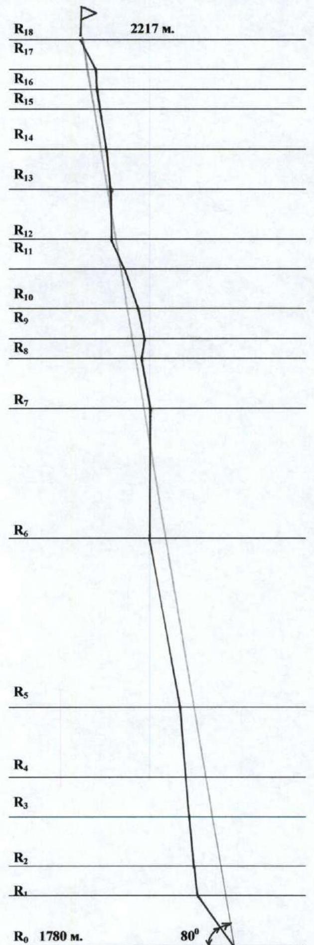
Sheet 2 Page 4 Timetable and ascent organization.
- February 20, 2003 Helicopter drop-off near "Staraya Krepost'".
- February 21, 2003 Route selection, tent setup under the route. Started processing. Processed sections R0–R3. Clear weather.
- February 22, 2003 Processed section R3–R5. Weather deteriorated, strong wind with snow. Advanced 20 m through an internal corner on section R5–R6.
- February 23, 2003 Processing impossible due to gusty wind with snow.
- February 24, 2003 Processed section R5–R6 and advanced 20 m through a chimney on R6–R7. Clear, strong wind.
- February 25, 2003 Processed section R6–R7 and half of section R7–R8. Clear, strong wind.
- February 26, 2003 Processed section R7–R11. Set up a tent at the start of section R11 using a hammock. Overnight stay.
- February 27, 2003 Processed section R11–R14. Snow, strong wind. Descended to the tent on R11 for overnight stay.
- February 28, 2003 Reached the summit. Clear weather, very strong wind. Descended from the summit via the plateau to the right bank of the lake. Returned to base camp.
- March 1, 2003 Rest day.
- March 2, 2003 Skiing. Descended along the Shirokaya Berezovaya river, ascended along the Karatas river to the pass. Overnight stay in the forest zone.
- March 3, 2003 Crossed the Karatas pass, descended on skis along the M. Kazyr river valley until meeting snowmobiles. Towed by snowmobiles to the "Kazyir" sports base.

Photopanorama of the ascent area. Sheet 3 Page 5
Brief Overview of the Ascent Area
The "Staraya Krepost'" peak, 2217 m, is located in the southeastern part of the Kuznetsky Alatau ridge, in a remote mountain-taiga region of Khakassia. It is a vast plateau, with gentle southwestern slopes adjacent to the Kuznetsky Alatau ridge near the Verkhny Zup peak.
To the northeast, the plateau drops off with sheer walls into a glacial cirque, at the bottom of which lies a lake. From the lake, the cirque resembles a granite "horseshoe" with an average wall height of 300–400 m.
Route characteristics:
- Possible route categories range from 3A to 6A.
- The walls are monolithic, strong, with very few cracks.
- The right part of the "horseshoe" is a monolithic massif, virtually devoid of cracks and micro-relief.
We chose a route in the central part of the wall with the maximum height difference.
To the southwest, in the "Golden Valley" area, there are several unclimbed peaks with possible routes up to category 5A. The area remains undeveloped due to its remoteness. The eastern part of the area is not of interest for mountaineering.
Strong winds are almost always present in this area, due to air currents moving from west to east, which accelerate on the plateau and then crash down onto the lake with hurricane force.
Access to the ascent area is quite challenging. From the city of Mezhdurechensk (Kemerovo region), take a train to the "Kazyir" stop, where the Kazyir sports base is located, then:
- Ski up the Maly Kazyr river valley;
- Cross the Karatas pass, enter the Bolshoy Khunul Khuzukh valley;
- Continue downstream to the confluence with the Karatas river;
- Continue down the Karatas valley until the confluence with the Bolshaya Berezovaya river.
At the headwaters of the Bolshaya Berezovaya, turn left to reach the lake — the location of the base camp.
From the lake's shore, there's a beautiful view of the wall, but it's more practical to set up base camp in the forest zone above the lake: the wall is not visible from there, but the wind is significantly weaker.
Tents heated by stoves are used for the base camp. There's no water available as the lake is completely frozen. The approach to the wall takes 2 hours.
The journey from the train stop to the base camp is 70 km, requiring 4–5 days for a group with good skiing skills. The snow cover is up to 4 m thick. The Maly Kazyr river valley is passable by snowmobiles, making it possible to organize cargo and personnel transport by "Buran" snowmobiles to the pass, significantly easing and shortening the journey. The fastest and most convenient transport is a helicopter from Mezhdurechensk.
Our group was helicoptered to the area and returned on skis. We traveled down the Maly Kazyr river valley from the pass to the railway on skis, towed by snowmobiles.
| Section # | Chocks | Pitons | Bolt Pitons | UIAA Route Diagram. Scale 1:2000 | Category of Difficulty | Length | Steepness |
|---|---|---|---|---|---|---|---|
| R18 | Summit 2217 m. Photo №8 | ||||||
| R17 | 3 | 1 | - | IV | 15 m | 65° | |
| R16 | 5 / 3 | 1 / 1 | - | VI А2е | 10 m | 90° | |
| R15 | 6 / 4 | - | - | V+ | 10 m | 80° | |
| R14 | 6 | - | - | V | 20 m | 80° | |
| R13 | 8 / 7 | - | 2 | VI А2е | 20 m | 80° | |
| R12 | 12 / 10 | - | 2 | VI А2е | 25 m | 90° | |
| R11 | 2 | - | 4 | V | 15 m | 60° | |
| R10 | 6 / 5 | 1 / 1 | - | V+ | 20 m | 70° | |
| R9 | 5 / 4 | - | 3 / 1 | VI А2е | 15 m | 80° | |
| R8 | 2 / 2 | - | 3 / 3 | VI А4е | 10 m | 105° | |
| R7 | 2 / 2 | 2 / 2 | 4 / 4 | VI А3е | 25 m | 80° | |
| R6 | 9 / 7 | - | 8 / 8 | VI А3е | 65 m | 90° | |
| R5 | 18 / 16 | 7 / 7 | - | VI | 85 m | 80° | |
| R4 | 4 / 3 | 4 / 3 | 4 / 4 | VI | 35 m | 85° | |
| R3 | 5 / 3 | - | 2 / 2 | VI | 20 m | 85° | |
| R2 | 8 | - | - | V | 25 m | 70° | |
| R1 | 3 / 2 | 2 / 1 | - | V+ | 15 m | 85° | |
| R0 | 2 | - | - | III | 30 m | 55° |
Sheet 4 Page 8
1:100 000
B) Brief Description of Route Passage by Sections
| Sections | Description |
|---|
Comments
Sign in to leave a comment