ASCENT DOCUMENT
- Region: Altai. Severo-Chuysky Ridge.
- Peak: 3740
- Proposed: 2B–3A category of difficulty
- Route type: combined
- Route description: Elevation gain — 960 m Route length — 2600 m Length of 3rd category of difficulty sections — 100 m Average slope — 40°
- Equipment used on the route: Ice screws — 6 Rock protection — 1
- Total climbing time: 13 hours
- Leader Suvorkina Lyudmila Davydovna CMS Team members: Ovchinnikov Vitaly Ivanovich 1st class Kraeva Ekaterina Mikhailovna III class Ulanova Alena Gennadievna III class Zemskov Alexey Alexandrovich III class Kamensky Andrey Konstantinovich III class
- Coach: Suvorkina Lyudmila Davydovna CMS
- Departure date: On the route — July 29, 2002 at 7:30 AM On the summit — July 29, 2002 at 3:30 PM Return — July 29, 2002 at 8:30 PM
- Organization: Krasnoyarsk Regional Center of Travelers
ALTAI MOUNTAIN SYSTEM.
The Altai mountain system is located in southern Siberia between 48–56° north latitude and is closely connected to the mountain ranges of Kuznetsk Alatau, Salair, Western Sayan, Tannu-Ola, and Mongolian Altai to the east. Altai is linked to them both in terms of orography and structure, making it difficult to draw a clear boundary. The boundary between Altai and Western Sayan is usually considered to be the watershed of the Biya, Abakan rivers, and the Shapshalsky Ridge. To the south and southeast, Gorny Altai connects with Mongolian Altai through the border massif Tabyn-Bogdo-Ola and the ridges extending from it, namely the South Altai, Saylyugem, and Chikhachev. The southwestern outskirts of Altai stretch to the Zaysan lake depression. To the north, Altai abruptly drops down to the West Siberian Plain in steps, and to the west, it fans out into a series of low ridges into the steppes.
The complex system of ridges with numerous spurs of varying heights and lengths can be visualized as follows. From the powerful mountain node Tabyn-Bogdo-Ola, a southern branch of ridges extends, gradually decreasing in height:
- South Altai, Sarymsakty, and Narymsky — to the west,
- Saylyugem and Chikhachev — to the east. To the north of this mountain arc, separated by the high Ukok Plateau and the Chuya depression, a fan of ridges unfolds, forming the backbone of this mountain system. One branch, with an almost sublatitudinal orientation, consists of the South Chuysky, Katunsky, and Holzunsky ridges. The latter branches out in a latitudinal direction into the Ivanovski, Ulbinski, and Ubinski ridges in its northwestern part. This line of ridges is the highest in Altai. Here, the highest peak in Siberia — Belukha (4506 m) rises. The second line of ridges — Severo-Chuysky, Terekta, and Bashchelaksky — lies to the north. From the junction of the Terekta and Seminsky ridges, the Cherginsky and Anuysky ridges extend northward, gradually decreasing in height. The third branch, formed by the Kurai, Aygulak, and Semultinsky ridges, stretches almost meridionally. The main fan-shaped pattern of Altai is complicated by the Chulyshman Highlands and the Shapshalsky Ridge adjoining from the east. The general trends include an increase in heights from northwest to southeast and a pronounced asymmetry of the slopes:
- northwestern slopes are steep,
- southwestern and southern slopes are gentle. Numerous rivers flow between the ridges along faults, characterized by deep valleys with steep slopes. Among the largest rivers are Bashkaus, Chulyshman, which feed Biya through Teletskoye Lake, and the rivers Chuya, Argut, Koksu, which are powerful tributaries of Katun. The rivers of Altai belong to the Altai type. They are primarily fed by melting snow waters and summer rains. They are characterized by a low flow rate in winter, a prolonged spring-summer flood, and a high water level in the rivers during summer, sustained by the melting of glaciers in Central and Southern Altai.
SEVERO-CHUYSKY RIDGE.
It stretches from northwest to southeast for 140 km, with a width of 50 km in the western part, gradually narrowing to 20–25 km to the east. The southern and southeastern boundary of the region is formed by the valleys of the Karagem and Chagan-Uzun rivers. The ridge reaches its highest height in the central part, known as the Bish-Iiridu mountain node, where the main glaciation of the ridge is concentrated. The average height of the ridge here is about 3600 m, and several peaks exceed 4000 m:
- Mashey-bashi — 4137 m
- Akturu — 4075 m The snow line height on the northern slopes is around 2900 m, on the southern slopes — 3100 m and higher. The orography of the ridge is complex and represents several roughly parallel ridges with a general west-east direction:
- Chuysky,
- Shavlinsky,
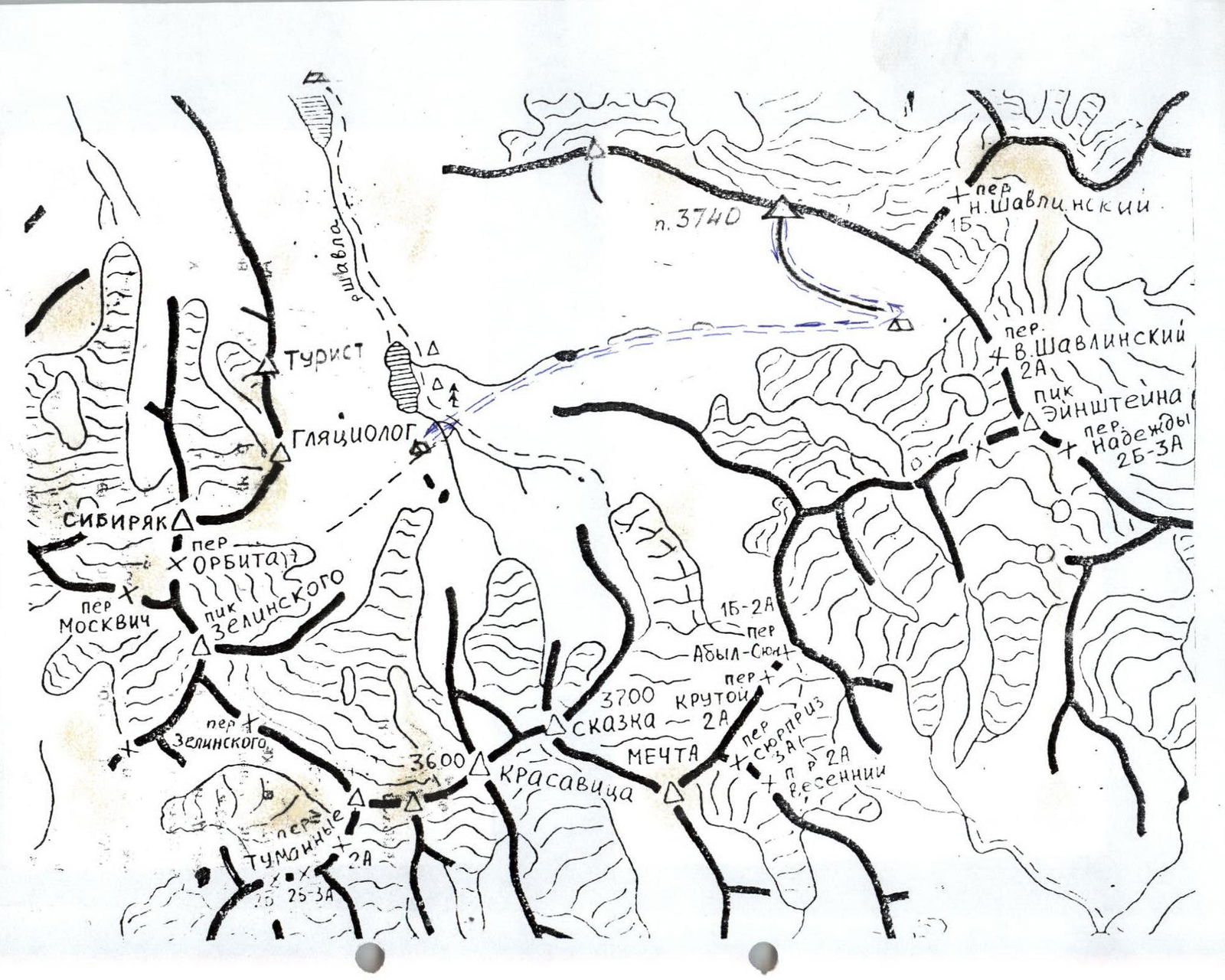
- Karagemsky. The Chuysky Ridge is located between the Chuya and Shavla rivers, stretching for 60 km in a latitudinal direction from the confluence of the Chuya and Katun rivers to the Eshtykol plateau. The heights of the ridge increase from west to east, with the highest point being 2925 m. The Shavlinsky Ridge is located between the Shavla and Yungur valleys. Near Argut, its height is around 2500 m; to the east, it rises, and beyond the right tributary of Yungur, the Kurundy river, glaciation appears on the ridge. The average height of the Karagemsky Ridge, which is the watershed between Yungur and Karagem, is 3400 m along its entire length. The ridge is covered with small glaciers, the area of which increases towards the center of the node. All the ridges converge into a single node in the area of the Sказка and Красавица peaks, located in the upper reaches of the Shavla river. Further to the east, the ridge represents a complex system of crests with developed valley glaciers and a number of northern and southern spurs, 20–25 km in length. The largest glaciation is:
- in the upper reaches of the Akturu, Maashay, and Shavla rivers;
- on the southeastern slopes — in the upper reaches of the Jelo and Karagem rivers. The eastern end of the ridge is marked by the Kупoл Tрех Oзер peak, crowned with a glacier, beyond which the ridge gradually degenerates. The most convenient approaches to the region are along the Chuysky tract. The starting point of the hike can be in the villages of:
- Belyy Bom,
- Chibit,
- Meny,
- Kurai,
- Kyzyl-Many.
Route description by sections
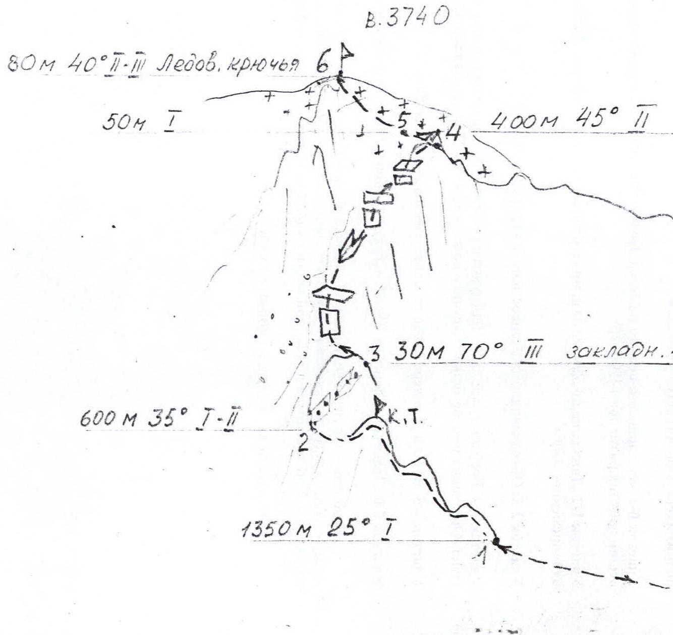
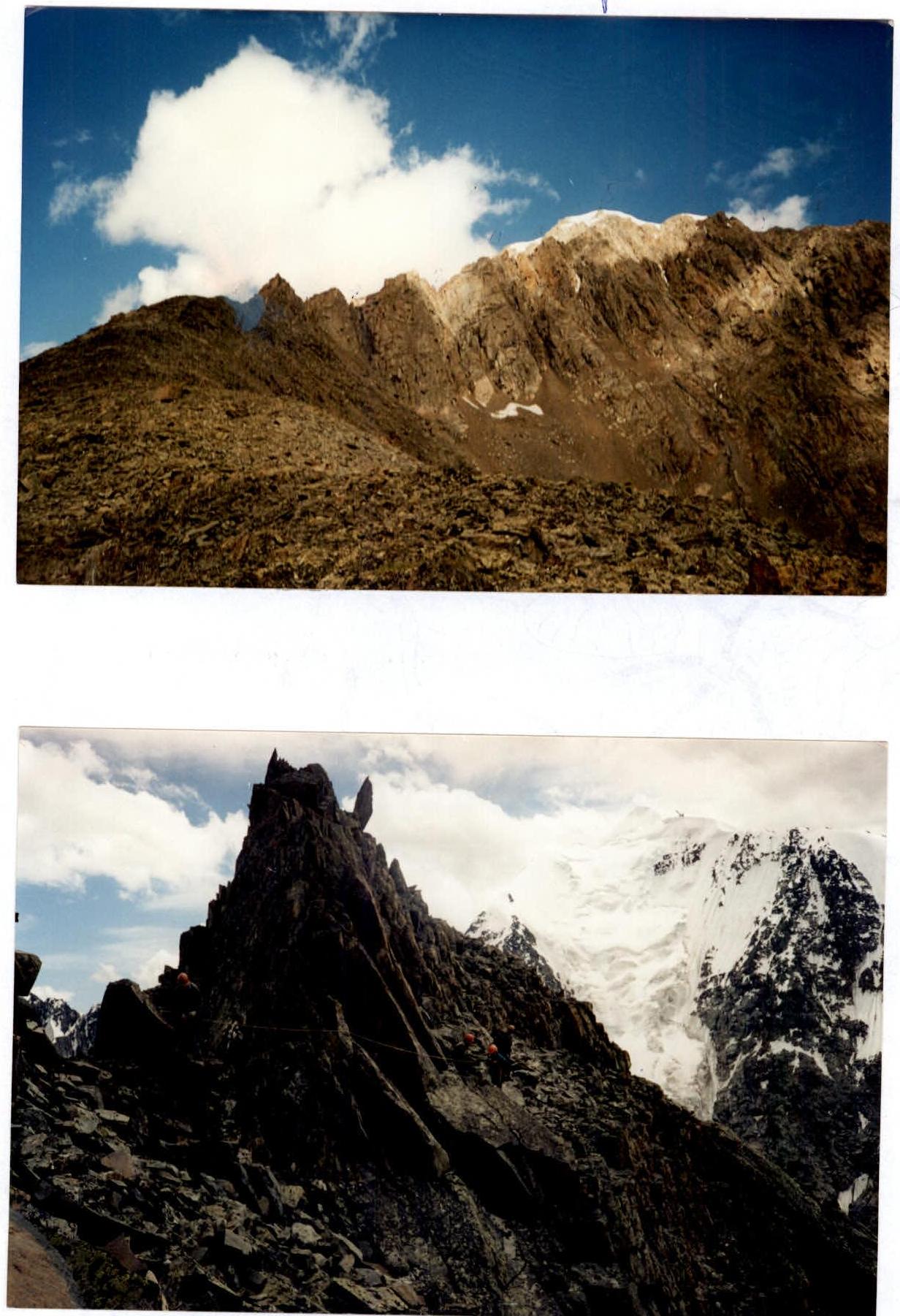
The 3740 peak is located in the ridge between the Verkhnee Shavlo and Nizhneye Shavlo valleys. From the camps located under the moraines of the glacial outwash from the Красавица and Cказка peaks, one needs to ascend a steep slope towards the waterfall that falls from the Abyn-Oyun valley. After ascending in an easterly direction, one needs to proceed along the Verkhnee Shavlo river valley towards the Upper Shavlinsky pass. At the end of the valley, under the Upper Shavlinsky pass, there are camps on the moraine. The path to the camps is marked by cairns and a fairly clear trail. From the camps, if one stands facing north, to the left on the ridge crest, which extends from the Upper Shavlinsky pass to the west, is a peak with a snowy summit. It can be ascended from the Upper Shavlo pass. The ridge that branches off from the peak and runs parallel to the main ridge, rising, ends at the camps.
Section R0–R1: From the platforms, ascent to the north. Ascent along a fairly wide ridge on medium-sized scree 1450 m, 25°. Section R1–R2: Movement along the gendarmes, keeping to the left side. Simultaneous movement 600 m. Section R2–R3: Bypassing a gendarme. Alternate belay 30 m, 70°. Section R3–R4: The ridge is sloping. Alternating between walls, inclined ledges, and internal corners. Alternate belay. Beware of rocks! 400 m. Exit onto the main ridge. Section R4–R5: Crampons. Traverse left towards the summit 50 m. Section R5–R6: Snow slope 80 m, 35–40°. Alternate belay. Ice screws.
The summit is an ice dome on the ridge, and a large ice massif along the entire ridge steeply descends to the north towards the valley with the Nizhnee Shavlinsky pass.
The cairn is located on the western part of the dome on rocks.
The descent from the summit follows the ascent route.
The total time for ascent and descent is 13 hours.