
Ascent Passport
-
Technical climb.
-
Altai, North-Chuysky Range, Abyl-Oyuk gully.
-
Einstein Peak 3900 m. Central part of the South Face.
-
Route 6A category of difficulty (approx.)
First ascent of the route.
-
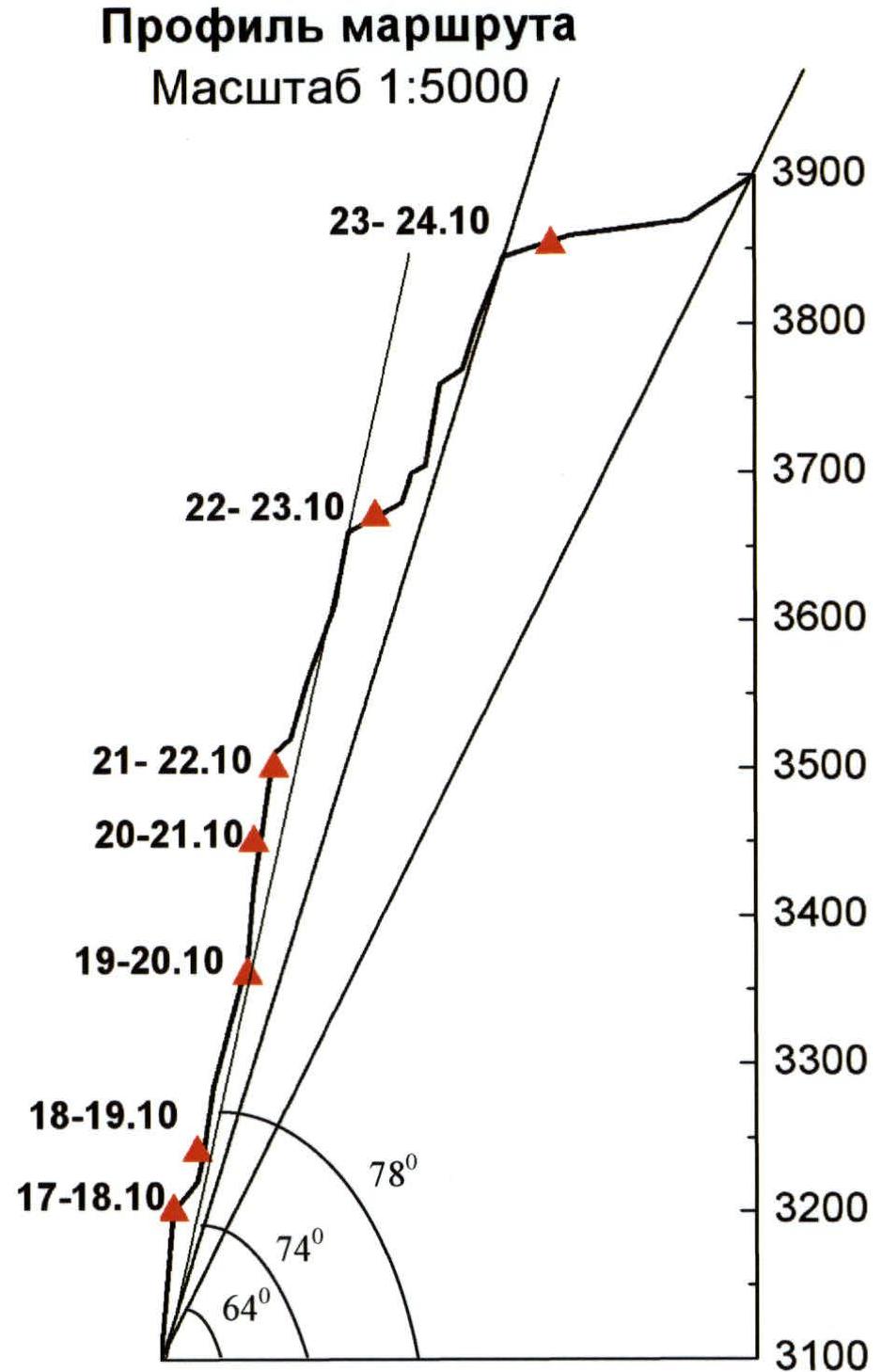
Route height difference: 800 m (wall base 3100 m – summit 3900 m).
Route length 900 m.
-
Length of the wall part of the route 760 m (height difference 710 m).
Bastion: length 600 m (height difference 560 m).
-
Length of sections with 5 category of difficulty 300 m.
Length of sections with 6 category of difficulty 350 m.
-
Average steepness of the route about 64° (from the base to the summit).
-
Average steepness of the wall part 74°; bastion 78°.
-
Number of driven pitons (including for artificial climbing techniques):
- rock pitons and rock anchors 60/35;
- drilled pitons 5/2 (skyhooks ~4 holes);
- chockstones (stoppers, cams, eccentrics, friends) 200/155;
- ice screws 7/3;
-
Team's walking hours 67: Days: 8;
-
Overnight stays: 7
1 – semi-reclining; 6 – reclining;
-
Team Leader:
- Kirikov Alexander Vyacheslavovich – CMS (Tomsk)
-
Participants:
- Oleinik Andrey Alexandrovich – CMS (Tomsk)
- Kolotilo Sergey Vladimirovich – 1st sports category (Tomsk)
-
Reconnaissance, route processing October 16, 2004.
Departure to the route: October 17, 2004. Summit: October 24, 2004 (10:30) Descent: October 24, 2004.
-
Organization: Tomsk Federation of Alpinism.
Overview of the area, characteristics of the ascent object
Einstein Peak is located in the North-Chuysky Range to the west of the highest point in the area, Maashey Peak. In recent years, the Maashey area has been visited by climbers quite frequently. However, due to its relative remoteness, it has not become as popular as the nearby Aktru or Ak-kem with its Shambhala and Belukha. The area has been known for a long time, and ascents to its main peaks were made back in the 1950s. The typical time for making ascents in the area is during the summer months. There is no information about technically serious routes in the area during winter. The main gullies where ascents are made are Maashey, Karakabak, and Shavlinskoye. At the same time, climbing groups usually enter the area through the settlements of Aktash or Chibit, ascending along the Maashey gully. The approach to the glacier takes 2–3 days.
Einstein Peak is one of the highest peaks in the area (3900 m), but at the same time, it is quite well hidden from climbers. According to the classifier, two routes were previously laid to the peak: 4A category of difficulty along its southern ridge (1956) and 2B category of difficulty along the northeastern wall of the southeastern ridge (1977). "It is not entirely clear where the route passes and which ridge is being referred to, or if there is a typo, or if they climbed somewhere else, as the Southeastern ridge cannot be 2B, maybe they climbed to Abyl-Oyuk Peak instead". Both routes to the mountain were made from the Shavlinskoye gully. Actually, the northern and southwestern slopes of the peak are visible from the Shavlinskoye gully. The upper part of the south wall, which is the most technically interesting, can only be seen from several high peaks in the area, such as Maashey, Krasavitsa, and Skazka. The wall is located in a kind of cirque formed by the Southern and Southeastern ridges and is also isolated from neighboring gullies by them.
The approach to the wall from under Maashey Peak takes several days and requires crossing the Nadezhda pass (2B category) and several rocky ridges – spurs of the North-Chuysky Range. The approach to the wall from Shavlinskoye Lake is possible through the Abyl-Oyuk pass and then through the icefall of the Abyl-Oyuk glacier. Apparently, the simplest approach to the mountain is from the south, from the Abyl-Oyuk gully, but it is not entirely clear how to get to this gully optimally.
Moreover, since the peak is not visible from the Maashey gully, and there are several unnamed peaks (or elevations in the ridge) to the west of Maashey Peak in the North-Chuysky Range ridge, the location of Einstein Peak and its height are indicated incorrectly on some maps and schematic maps. "Although it may be correct, but not as and not where it is in the classifier, i.e., a different peak is implied". This is shown on the maps and schematic maps attached to the report. On some photographs on the internet, the height 3601 m is also referred to as Einstein Peak. Accordingly, there are often doubts and disagreements among climbers about the actual location of the peak. Although mountain tourists passing through the Abyl-Oyuk gully usually identify the peak correctly. However, from the lower part of the gully, peak 3601 m is simply not visible, so there is no confusion there. A panoramic photograph of Einstein Peak, height 3601 m, and Maashey Peak from the south, taken from the slopes of the Abyl-Oyuk gully, is also attached.
The south wall drew our attention as a potential object for ascent several years ago, after reconnaissance (attempted ascent?) conducted by a team from Novosibirsk (Ivanov V., Avdienko A.). They also provided some technical photographs (one is attached: face of the wall) and information about the wall: height difference of the wall part 600–700 meters, very good overhang. After approaching the wall, the Novosibirsk team decided that the amount of equipment they had was insufficient for passing the route on the wall. It is also known (information obtained from CSP Gorno-Altaisk) that in the summer of 2004, a group of French guides came to Altai with the goal of climbing Einstein Peak via the South wall. The group was released in Gorno-Altaisk with an interpreter, and a month later, the deadline was extended, but the outcome of their endeavor was unknown. We did not find any traces of the French team's presence under the wall, on the wall, or on the summit; most likely, they did not climb the wall, and it is unclear whether they attempted to or not. "It is entirely possible that the route thread could have passed differently. But it is unlikely".
Approaches
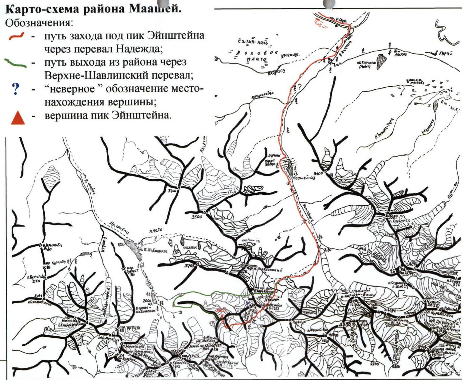
The scheme of our team's approach to the route and exit from the area is shown on the schematic map. We approached through Chibit settlement via Maashey gully, Nadezhda pass, and two rocky spurs into the cirque under the wall. The approach took 5 days (11–15 October). With normal acclimatization and less snow in the summer, it is possible to approach in 3–4 days.
Tactics
The time for the ascent was deliberately planned for the off-season – October. In this month, it is still warm enough, but at the same time, there is significantly less rockfall danger on the routes (Altai is still quite old and heavily eroded mountains). In October, the temperature on the wall with its southern orientation did not rise above zero degrees. The wall is frozen. At the same time, it is still quite warm compared to winter months.
Weather conditions during the ascent were relatively favorable:
- Night and morning temperatures around −15 °C, possibly slightly lower.
- During the day – −5 – −10 °C.
- There was no prolonged bad weather (weeks without a break).
- Although it snowed continuously on the route for a couple of days.
- There were also a couple of sunny days.
Since we did not have normal information about the descent from the summit (at the time of the ascent, there was no certainty that the summit was indeed Einstein Peak), and we were working as an autonomous group (without support), from the very beginning, we had to minimize the amount of equipment and supplies, as in the end, everything had to be carried through the mountain. At the same time, autonomy and remoteness from the nearest settlements required a sufficient margin of safety. Therefore, we worked in what can be called a "cargo version", not overexerting ourselves. It turned into a "hike with an ascent".
During the approaches and on the wall, the average working day lasted around 8 hours. We could have worked more (i.e., passed the route faster), but the margin of safety would have been lower, and the work would have been exhausting. Much attention was paid to organizing comfortable overnight stays; the equipment allowed for dry and reclining nights. As a result, we passed the wall very confidently.
Exit from the area
On the summit, we found a control cairn with a note from 1997 of "strange" content (the note is attached). The group ascended to the summit of Einstein Peak via a route of either 2A or 3A category of difficulty (there are no such routes in the classifier). The most logical and simplest descent route from the summit appears to be the western ridge, which descends into the Shavlinskoye gully. We descended via this route. The descent is approximately 3A–3B category of difficulty (but very long). We descended from the summit from 11:00 to 18:00. We descended under Krasavitsa and Skazka peaks. Then we exited through the Upper Shavlinskoye pass (2A category) into the Maashey gully and further down to Chibit. The exit took 3 days (or 4 days if counting the day of descent from the summit). During our stay in the area (16 days), we did not see anyone. The area is sparsely visited during the off-season and winter.
About the route and the wall
The wall is very atypical for Altai. The steepness of the wall part, the nature of the relief, and the abrupt beginning of the wall (you walk on snow and suddenly face an overhanging rock) make the object quite unique. The rocks forming the wall are very diverse – in terms of relief character, strength, and degree of destruction. There are monolithic, large-block sections (upper tower, sections R18–R20), sections with quite rotten rock (R5), and sections with blind cracks (R11). A characteristic feature is the presence of rock "feathers": detached layers of rock 7–10 m long, a couple of meters wide, and 1 m or less thick, standing on ledges sometimes in an unclear manner.
On the wall, we used the entire arsenal of available equipment. Rock anchors were used intensively. Four stationary drilled pitons were placed on the route at belay stations for insurance. One drilled piton was used to pass section R7, and holes were drilled for skyhooks on the same section. Section R3 was passed on fists.
At least three very logical lines (5B–6A category of difficulty) are visible on the wall, suitable for both free climbing (in summer) and good routes using artificial climbing techniques. Our group did not pass the most difficult line. To pass some routes, it is likely necessary to use a platform.
Our route is not recommended for climbing in summer due to rockfall danger on some sections.
Note
In autumn 2003, Altai experienced a series of earthquakes. Judging by photographs taken before and after the earthquake, the relief of the wall has changed noticeably.

General photo of Einstein Peak (3900) (October 15, 2004)

Einstein Peak 3900 m.
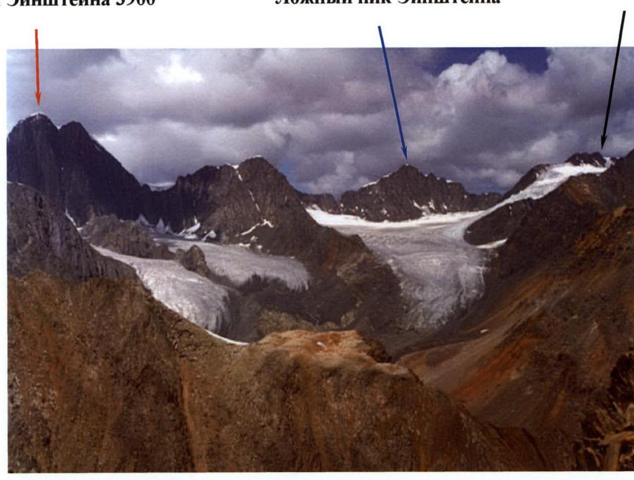
View from the south
Maashey Peak area map
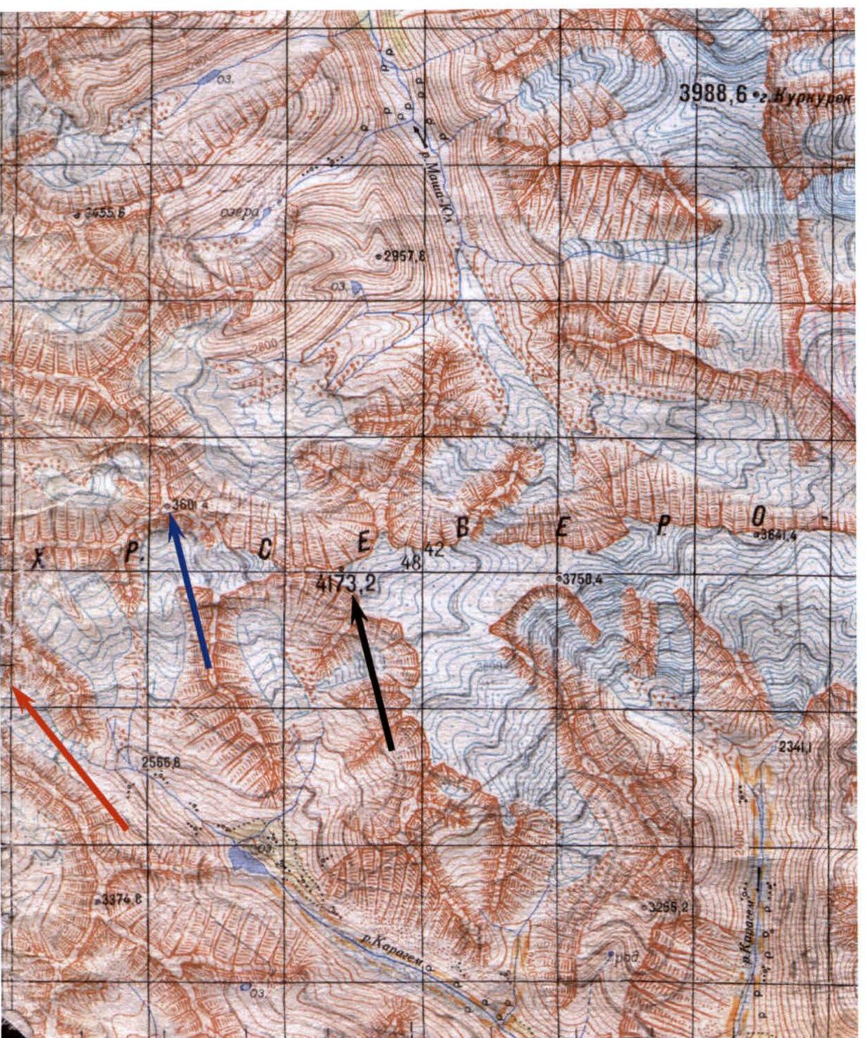
Location of Einstein Peak 3900 m. 4173.2 Maashey Peak. Schematic map of the Maashey area. Denotations:
- path to Einstein Peak through Nadezhda pass;
- path out of the area through Upper Shavlinskoye pass;
- "incorrect" designation of the peak location;
- Einstein Peak.

Photograph of the south wall taken by the Novosibirsk team. (approx. – summer 2002)
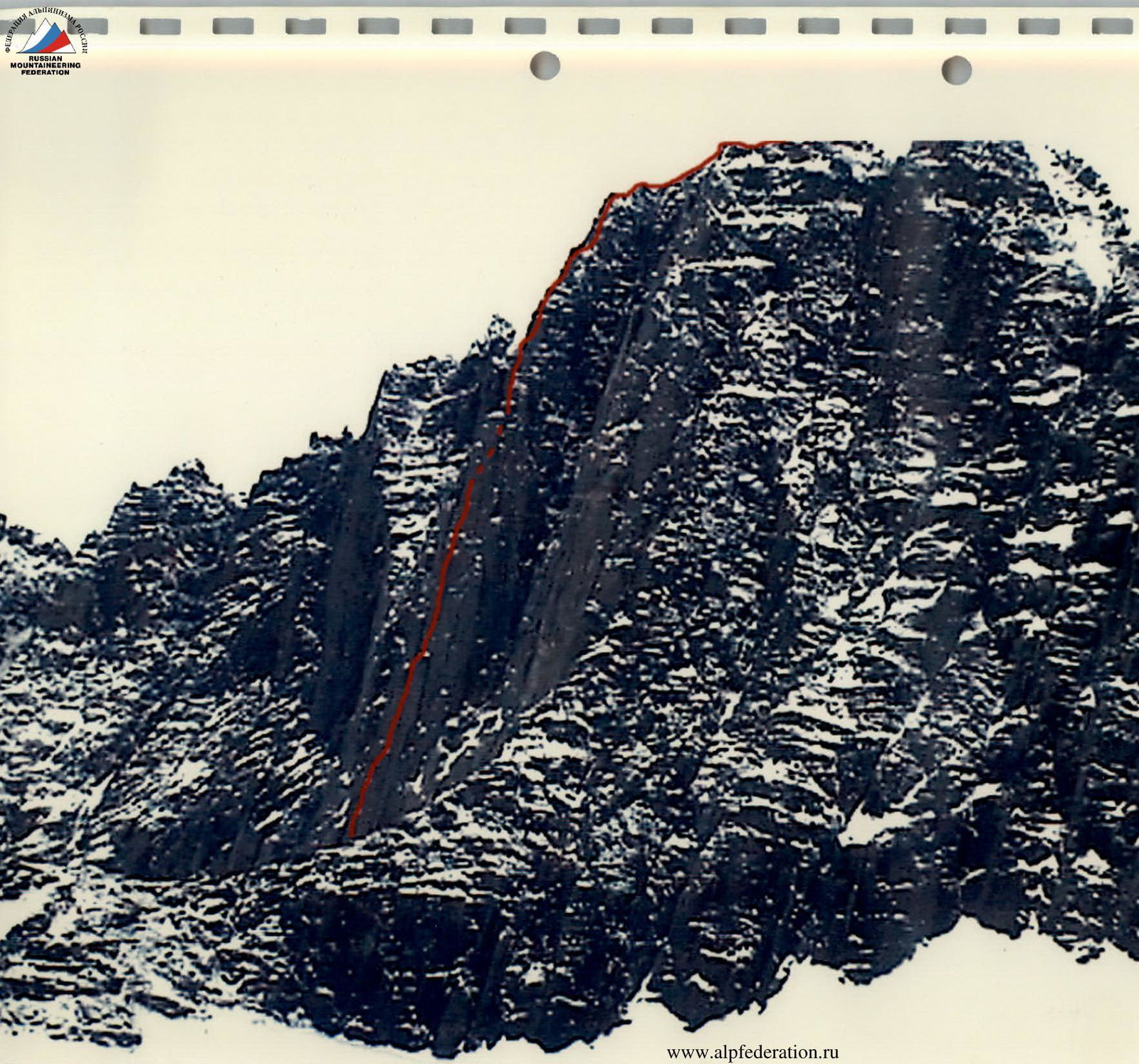
Photo of the profile of the South wall of Einstein Peak.
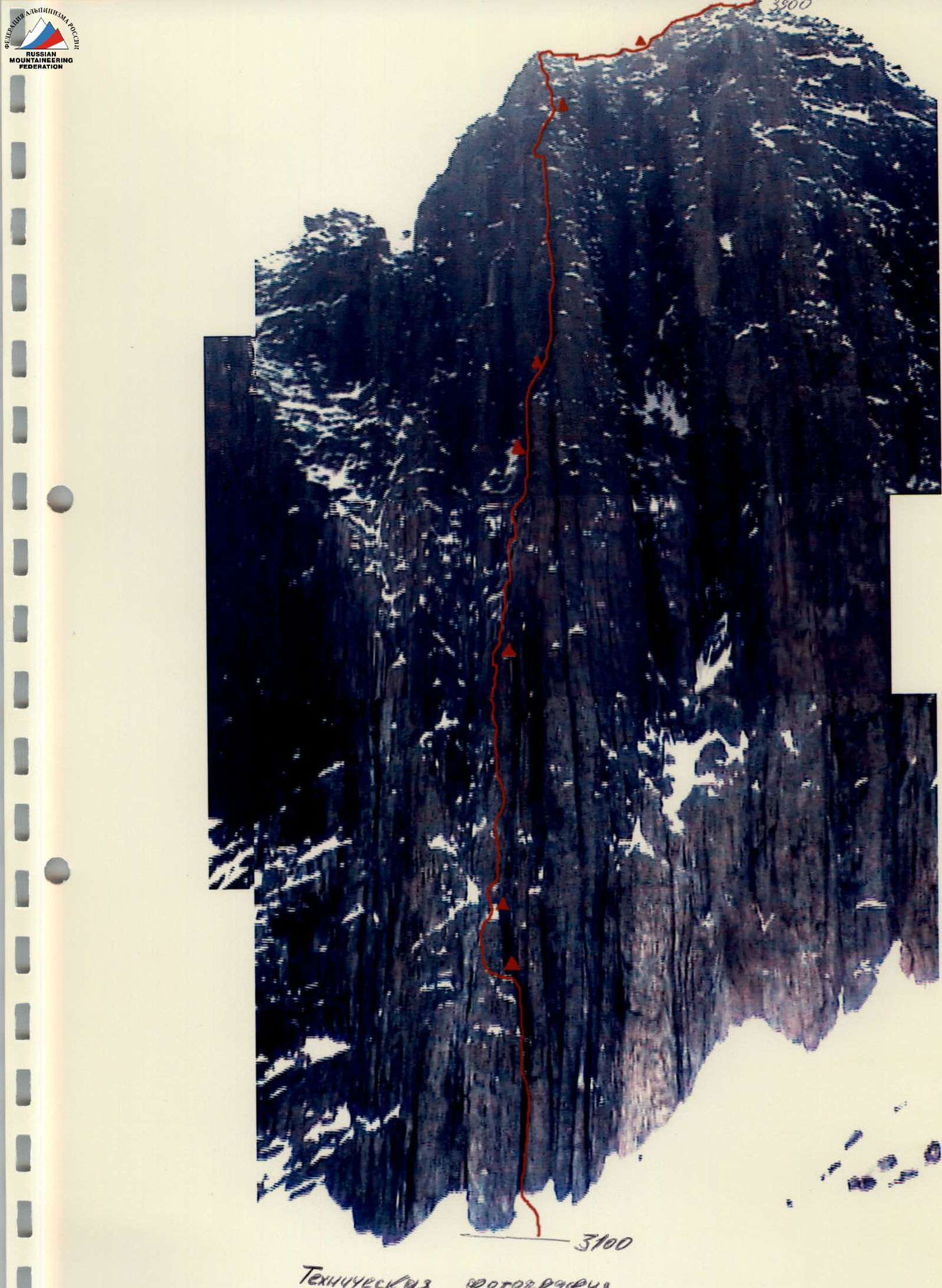
Technical photograph of Einstein Peak (South wall)
Overnight stays locations
64° – average angle from the base to the summit (sections R1–R22), 74° – average angle of the wall part of the route (R1–R21), 78° – average angle of the bastion (R1–R16).
Scheme of ascent to Einstein Peak 3900 m via the central part of the South wall in UIAA symbols
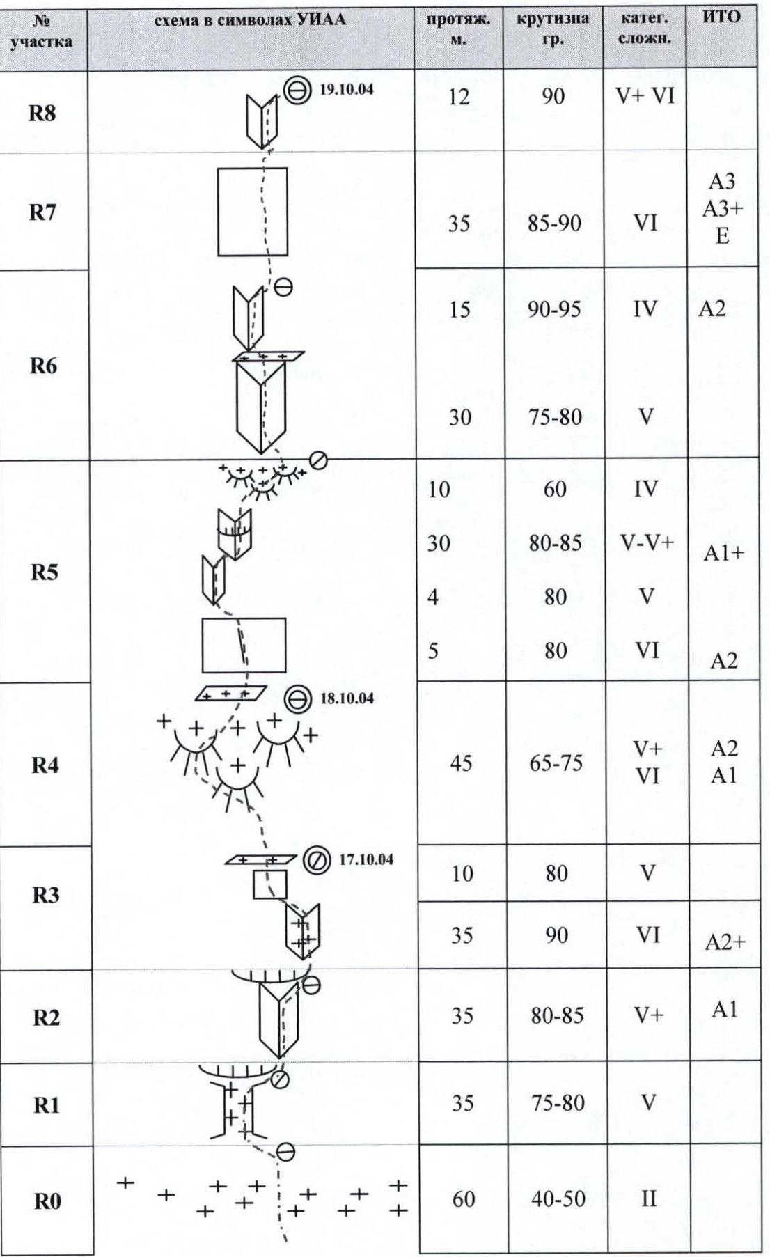
| Section # | UIAA symbol scheme | Length, m | Steepness, ° | Cat. diff. | Aids |
|---|---|---|---|---|---|
| R17 | 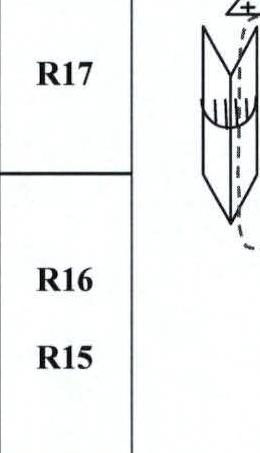 | 45 | 85–90 | 5–5+ | A2 |
| R16 | |||||
| R15 | 35 | 85–90 | 5+–6 | ||
| R14 | 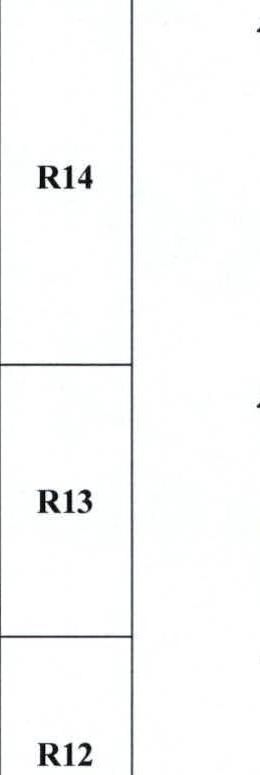 | 10, 15, 15, 4 | 5+–6, 6, 5, 5+ | A2, A3, A2 | |
| R13 | 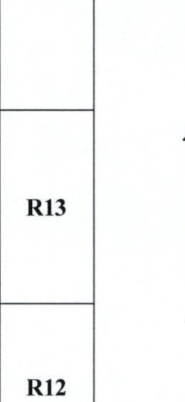 | 4, 40 | 90, 80–90 | 5+, 5+–5 | A2+, A3 |
| R12 | 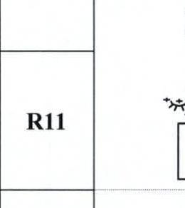 | 30, 8, 8 | 60, 80, 75 | 4–4 | |
| R11 |  | 5, 40 | 95–100, 75–85 | 6, 5+–5 | A1+, A2+, A3 |
| R10 | 40 | 70–80 | 5 | ||
| R9 | 12 | 90–95 | 6 | A2 | |
| R22 | 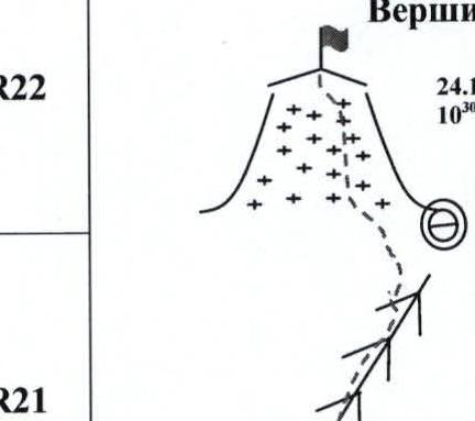 | 100 | 30 | 2 | |
| R21 | 130 | 45–60 | 4–5 | ||
| R20 | 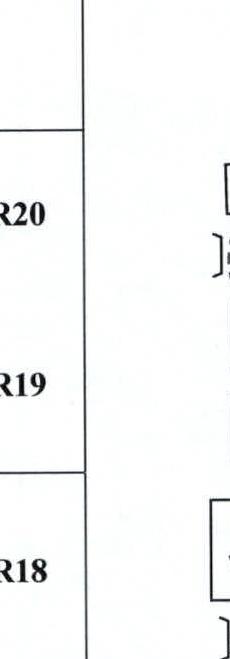 | 6, 8, 20, 15 | 80, 90, 80, 90 | 4, 6, 5+, 5+, 6 | A1, A1+, A2, A2+ |
| R18 | 30, 10 | 70, 90 | 5, 6 | A1 |
Route description by sections
| Sect. # | Date | Rope # | Description | | R0 | 17.10 | | Firn slope 40–50°, ~60 m straight up. (2 category of difficulty), simultaneous movement. | | **first overnight stay. | | | We stopped for the night on a small snow ledge. The ledge is located in the upper part of the first rock outcrop, to the left of the bastion. The width of the ledge is about 60 cm, and we extended it by 30 cm using a "sheet". The overnight stay is semi-reclining.
Comments
Sign in to leave a comment