Ascent Certificate
for N. Shavlinskaya peak, 3400 m, 3A cat. diff.
-
Mountainous Altai, North-Chuya Range, eastern spur of the main range between the Maasha (Mazhoy, Maasheyul) river gorge and the Shavla river gorge.
-
N. Shavlinskaya peak, 3400 m, via the Central spur of the Northern slope and the Eastern ridge.
-
Proposed — 3A cat. diff., first ascent.
-
Route type — combined.
-
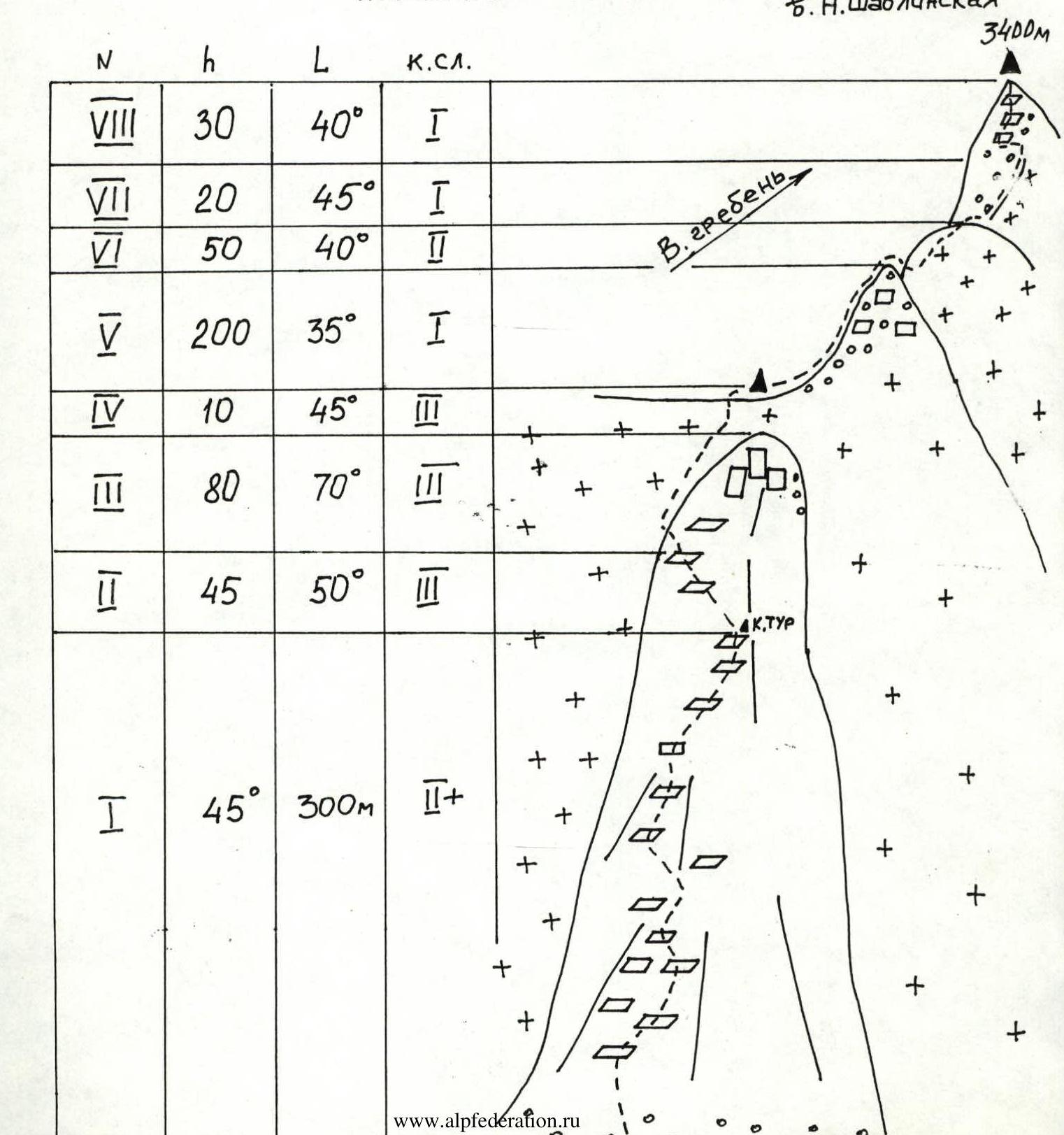
Height difference of the route: 800 m (by aneroid barometer).
Route length: 735 m. Length of sections:
- 1st cat. diff. — 250 m;
- 2nd cat. diff. — 350 m;
- 3rd cat. diff. — 135 m. Average steepness of the main route part — 45°.
-
Pitons left on the route — none.
Use of pitons on the route — 10 ice screws.
-
Team's climbing hours: ascent — 9 h 30 min.
-
Leader: Baranov Viktor Aleksandrovich, 1st sports category.
Participants:
- Ermolaev Yu.A., Candidate for Master of Sports;
- Sorin A.A., III+ category;
- Konovalov A.V., III+ category.
-
Coach: Ermolaev Yuriy Aleksandrovich, Candidate for Master of Sports.
-
Departure for the route: — 6:30, August 11, 2002.
Summit arrival: 12:00. Return to base camp: 16:00.
Climbing Area Description
East of the Katun Range, beyond the Argut river valley, lies the North-Chuya Range. It stretches from northwest to southeast for 140 km, with a width of 50 km in the western part, gradually narrowing to 20-25 km in the east. The southern and southeastern boundaries of the area are defined by the valleys of the Karagem and Chagan-Uzun rivers. The range reaches its highest elevation in the central part, known as the Bish-Iirdu mountain node, where the main glaciation is concentrated. The average height of the range here is about 3600 m, with several peaks exceeding 4000 m (Maashey-bashi — 4173 m, Akturu — 4075 m).
The passes of the range vary, but they share a common characteristic — the northern and northeastern slopes are steeper, with higher ascents. The difficulty categories of the passes range up to 3B, with the most serious passes being snow-ice in nature. The snow line is at around 2900 m on the northern slopes and 3100 m or higher on the southern slopes.
The orography of the range is complex, comprising several roughly parallel ranges with a general west-to-east orientation — the Chuya, Shavla, and Karagem ranges. The Chuya Range is located between the Chuya and Shavla rivers, stretching for 60 km in a latitudinal direction from the confluence of the Chuya and Katun rivers to the Eshtykol plateau. The heights of the range increase from west to east, with the highest point being 2925 m. Many river valleys and the watershed have trails. The watershed is marshy in some areas.
The Shavla Range is situated between the Shavla and Yungur valleys. Near the Argut, its height is around 2500 m, rising to the east, and beyond the right tributary of the Yungur, the Kurundy river, glaciation appears on the range. Forests grow only in the river valleys. The most challenging passes and peaks are located in the eastern part of the range, which encircles the Shavla mountain lakes in a horseshoe shape.
The average height of the Karagem Range, which forms the watershed between the Yungur and Karagem rivers, is 3400 m throughout its length. The range is covered with small glaciers, the area of which increases towards the center of the node.
All the ranges converge into a single node in the area of the Skazka and Krasavitsa peaks, located in the headwaters of the Shavla river. Further east, the range forms a complex system of ridges with developed valley glaciers and a series of northern and southern spurs, each 20-25 km long. The most significant glaciation is found in the upper reaches of the Akturu, Maashey, and Shavla rivers, and on the southeastern slopes, in the headwaters of the Dzhelo and Karagem rivers.
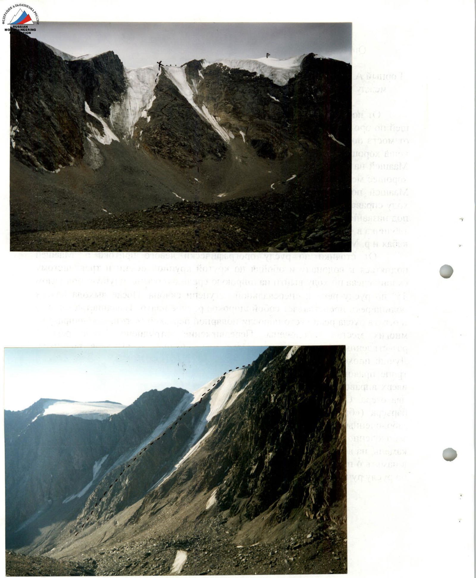
Map-scheme of the Maashey and Shavla gorges
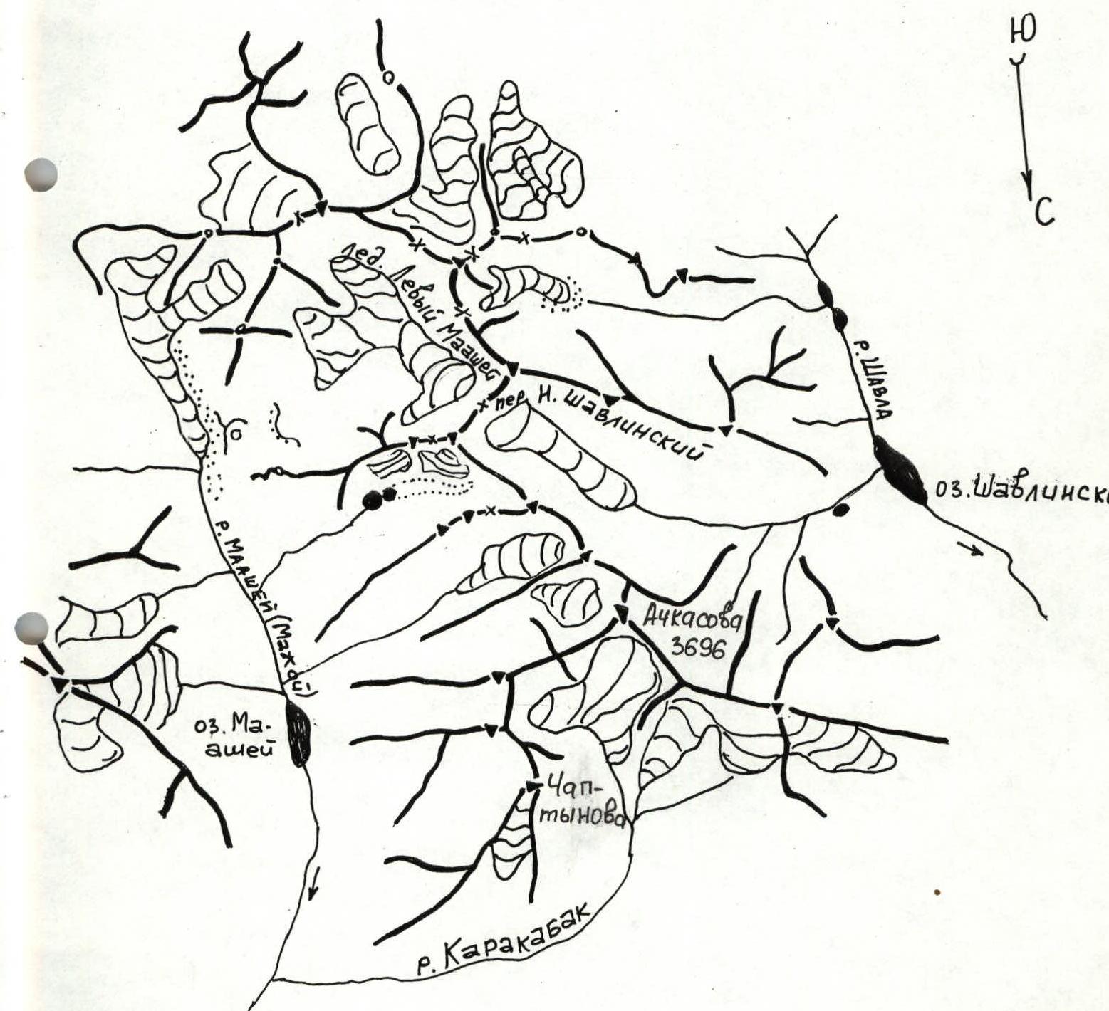
Map-Scheme
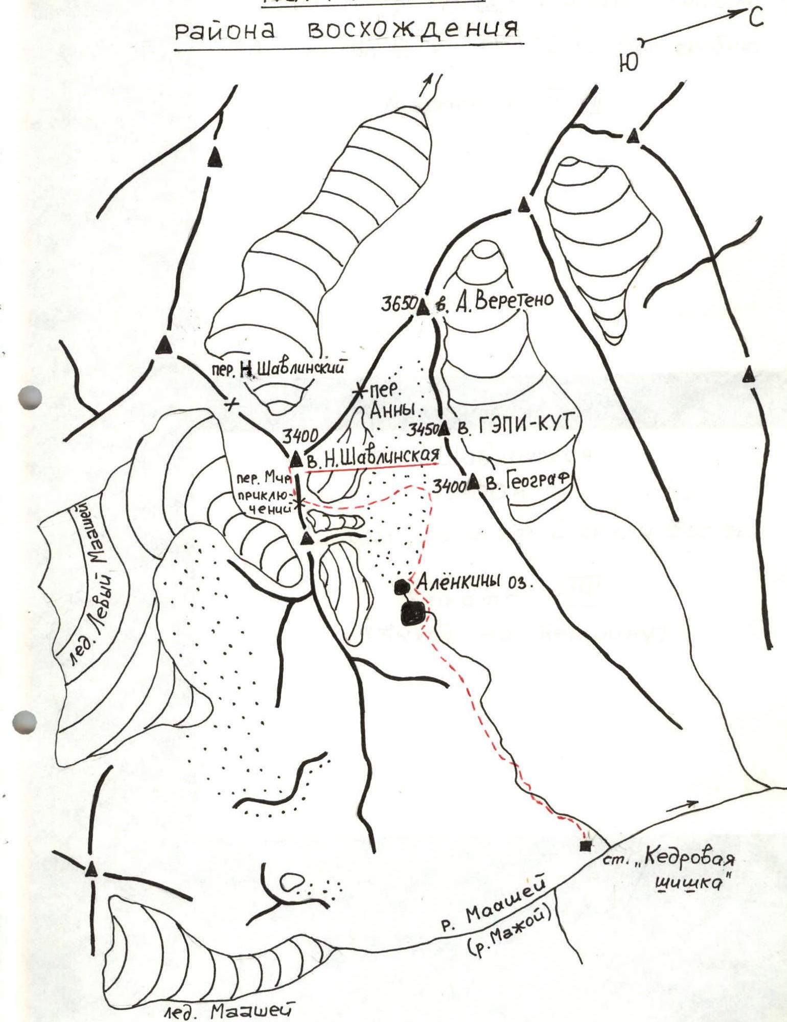
Description of Approaches to N. Shavlinskaya Peak Route
Mountainous Altai, North-Chuya Range, eastern spur of the main range between the Maasha (Mazhoy, Maasheyul) river gorge and the Shavla river gorge.
From the Chibit settlement to the wooden bridge over the Chuya river at its confluence with the Maasha river, a dirt road runs along the left bank. The approach starts from the bridge, following a steep serpentine path, then continuing on a dirt road to the old koshi.
From the koshi, a good trail traverses along the left bank to the point where the Maasha river turns towards its confluence with the Karakabak river. Crossing is done on logs near the confluence. This is a good spot for camping. The journey from the bridge takes ~3 hours.
Climb along the left bank of the Maasha river on a trail to Maasha Lake (1.5-2 hours). Bypass the lake on the right, and 30 minutes before reaching the glacier tongue, exit to a campsite known as "Kedrovaya Shishka" (Cedar Cone). At the campsite, a plaque on a large stone commemorates a deceased tourist named Alena. From the campsite at the confluence of the Karakabak and Maasha rivers to the "Kedrovaya Shishka" campsite takes 3-4 hours.
From the campsite, ascend along the left tributary of the Maasha river to a waterfall, and by traversing a steep, large talus slope and a grassy slope on the left, exit onto a broad, middle talus slope, which ascends at a 45° angle along the riverbed to the "pass" step of the slope. After reaching the top, the river valley opens up into a wide, flat plateau. The grassy slopes and riverbed banks are densely overgrown with polar birch ("ertnik", "chira") and are marshy in many places, making movement difficult. The riverbed has multiple watercourses, with many seepages and spring outlets. It's better to cross the riverbed to the left and follow a frequently disappearing trail on the right bank past large stones ("gates"), then traverse upwards to the right, exiting via "ram's forehead" steps to "Alenka's" lakes — two lakes. The lakes are connected and lie between the moraine and the barrier ("ram's foreheads"), and between the northern talus slopes and the southern marshy and grassy slopes of the gorge. The lakes are bypassed on stones and marshy shores on the right. Behind the first lake, there's a characteristic hill-stone with a cairn on top. A plaque is also fixed on a stone in the lower part, commemorating the deceased tourist Alena. It's better to set up a campsite further upstream along the stream. From the "Kedrovaya Shishka" campsite to the lakes takes 2-2.5 hours.
Route Description
N. Shavlinskaya Peak, 3400 m, 3A cat. diff. (combined), via the Central spur of the Northern slope and the Eastern ridge. First ascent
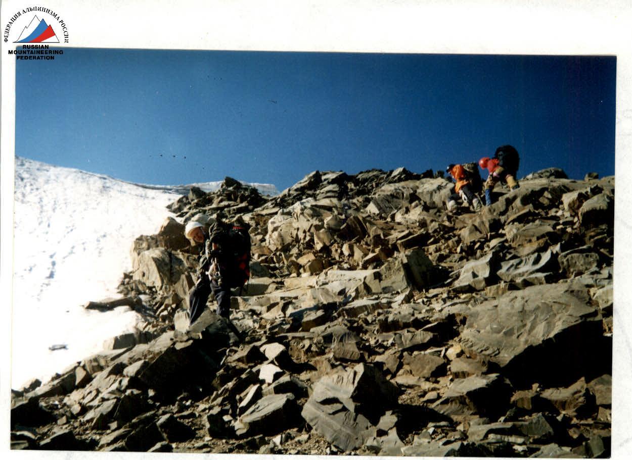
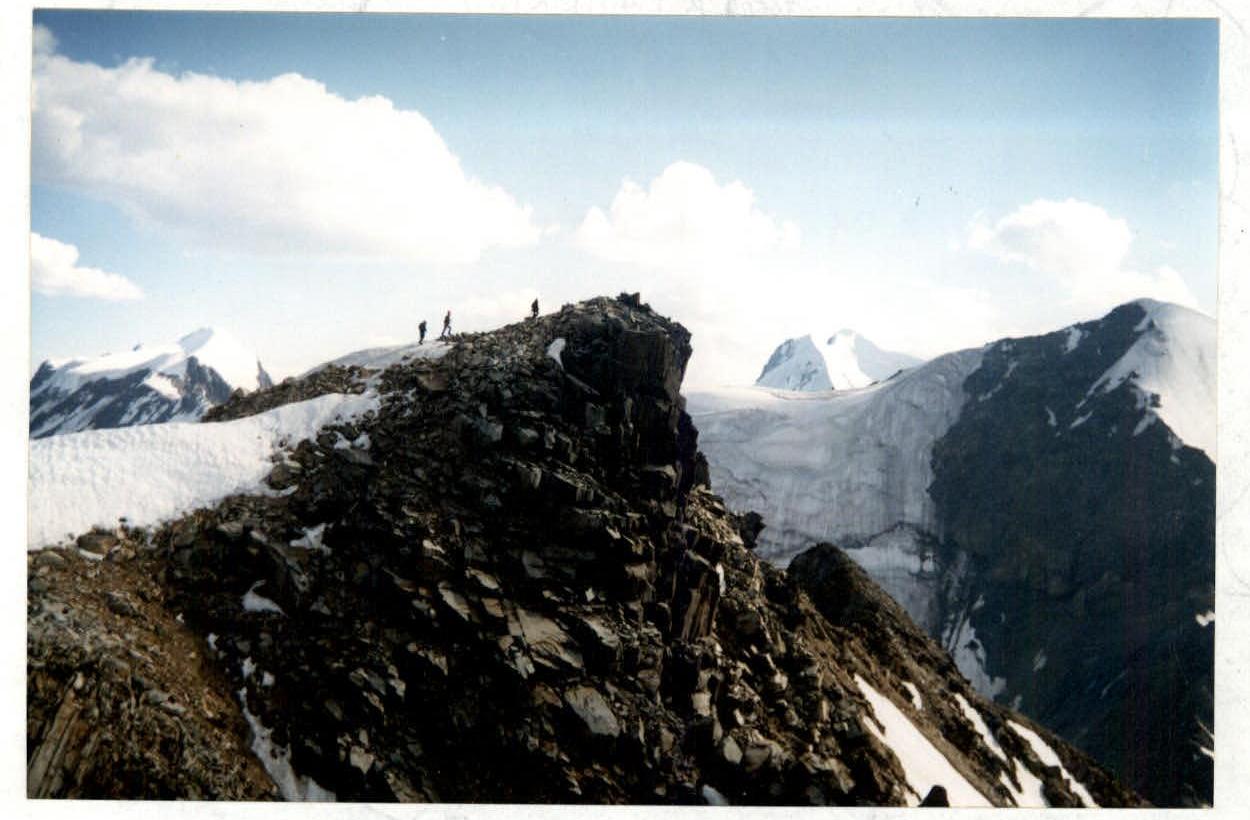
From the forward camp near "Alenka's" lakes, move upwards, orienting along the left bank alongside the 1st Lateral moraine ridge. Before reaching the 2nd moraine ridge, cross the moraine and exit onto the northern slope's talus, which leads to a broad spur between parallel hanging glaciers. The start of the route is to the left of the middle part of the spur. Ascend via inclined ledges, stepping up to the ridge part of the spur (many loose rocks and wet rocks — protection via protrusions, stick to the ridge parts of the spur). In the lowering of the ridge, there's a control cairn. Above this section, the ridge is peppered with "live" stones, so it's better to proceed on the left side along slabs and a wall (alternate protection). Then, exit onto an ice slope (length 60 m, steepness 70°). Movement is with alternate protection via ice screws. Exit onto an ice plateau above the rocky spur and, with piton protection, traverse an ice-snow cornice 2 m. Exit onto the saddle of the "Mir Priklyucheniy" (Adventure World) pass (2A) on a broad ridge. The southern slope is a gentle, fine talus, descending to the Left Maashey glacier. Along the broad ridge and destroyed rocks, exit onto a "marble" pre-summit, descend into a depression, and by traversing left-upwards on an ice dome, exit to a snowy ridge "knife-edge", passing it to the rocks, and exit via destroyed rocks to the summit. On the edge of the platform, a cairn is established. Descent follows the ascent route to the "Mir Priklyucheniy" pass to an intermediate camp, preferably on ice with rope retrieval at 3 points, then to the middle part of the spur, into a couloir along talus ledges to talus.
Total ascent time is 3-3.5 hours, height difference is 450 m, length is 700-800 m, estimated cat. diff. 3A.
Ascent leader Baranov V.A. reg. No. 882 August 25, 2002
N. Shavlinskaya Peak, 3400 m. Via the Central spur of the Northern slope and the Eastern ridge, 3A cat. diff. (combined) First ascent N. Shavlinskaya Peak, 3400 m.
| Section | Length, m | Steepness, ° | Cat. diff. |
|---|---|---|---|
| R8 | 30 | 40 | 1 |
| R7 | 20 | 45 | 1 |
| R6 | 50 | 40 | 2 |
| R5 | 200 | 35 | 1 |
| R4 | 10 | 45 | 3 |
| R3 | 80 | 70 | 3 |
| R2 | 45 | 50 | 3 |
| R1 | 300 | 45 | 2 |