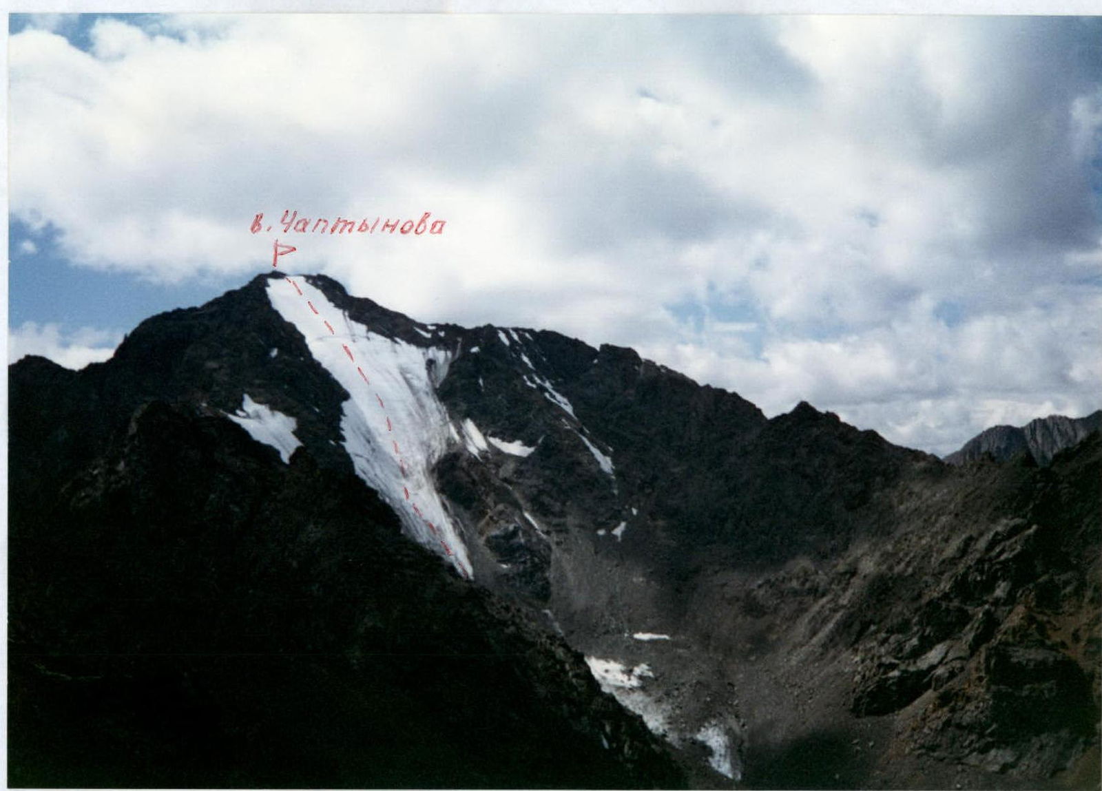
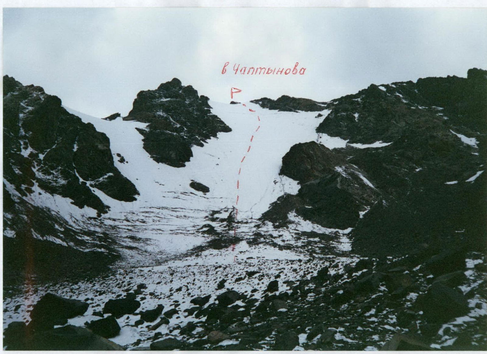
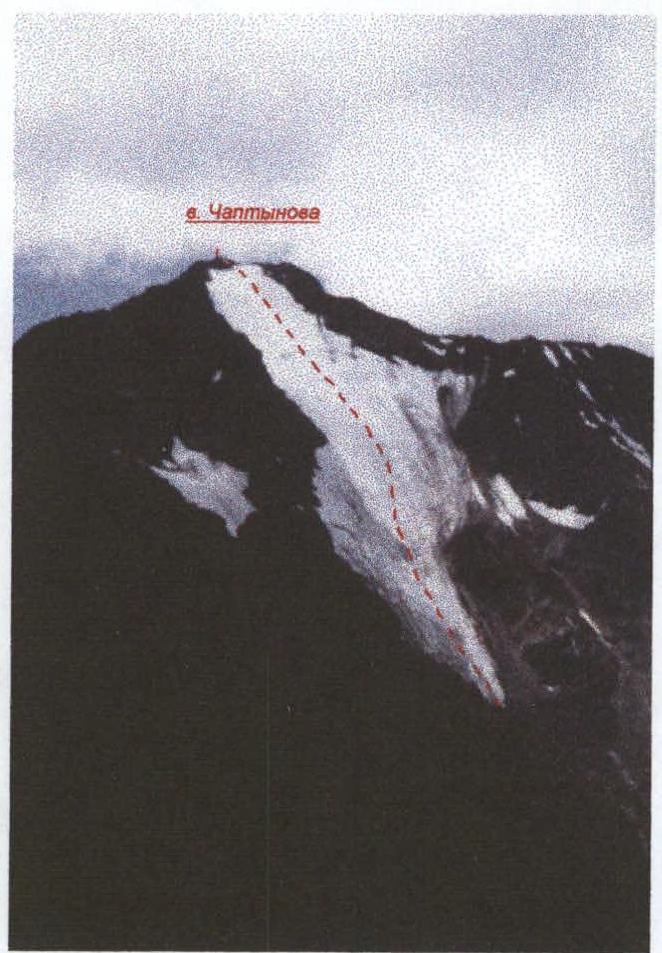
Chaptynova peak via the direct line of the northern slope
Barnov S.I. Altai, Severo-Chuysky Ridge 1.2
Passport
- Class: first ascent.
- Altai, Severo-Chuysky Ridge, Karakabak gorge, 1.2
- Chaptynova peak, via the direct line of the northern slope, ice-snow route.
- Proposed category: 3A, first ascent.
- Elevation gain: 350 m; length – 650 m. Average steepness of the route – 25–30°.
- Number of ice screws used on the route: 15.
- Team's travel time: 3:15 from the glacier to the summit; 6:45 from glacier to glacier; 13:15 from base camp to base camp.
- No overnight stays.
- Leader: Barnov Sergey Ivanovich, 1st sports category.
Participants:
- Eremin Andrey Anatolyevich, 2nd sports category;
- Komissarov Dmitry Alexandrovich, 3rd sports category;
- Neyaskina Olga Vladimirovna, 3rd sports category.
- Coach: Tumyalis Vladimir Vitalius, 2nd category.
- Departure from base camp: 6:45, August 24, 2000. Start of the route: 10:45, August 24, 2000. Reaching the summit: 14:00, August 24, 2000. Return to base camp: 20:00, August 24, 2000.
- Organization: Barnaul mountaineering camp.
Photographs of the route and surroundings
Chaptynova peak, via the direct line of the northern slope, shot location #1
Chaptynova peak, via the direct line of the northern slope, shot location #2
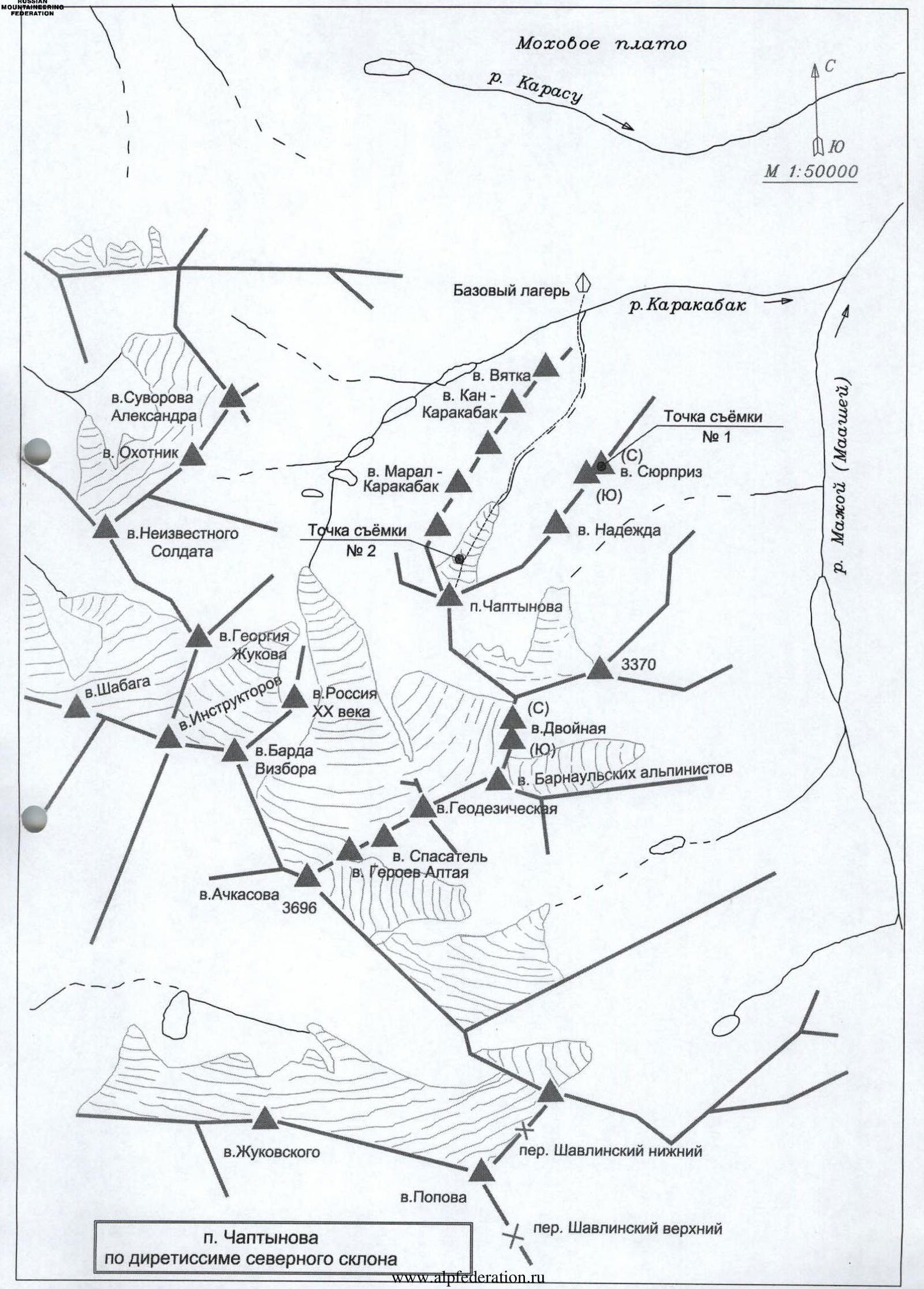
Area map
Chaptynova peak via the direct line of the northern slope
Map legend: Moxovoe plateau Karasu river M 1:50000 Base camp Karakabak river Vyatka peak Suvorova Alexandra peak Okhotnik peak Neizvestnogo Soldata peak Kan-Karakabak peak Maral-Karakabak peak Shot location #2 Shabaga peak Georgiy Zhukov peak Instruktorov peak Rossiya XX veka peak Vizbor peak Achkasova peak 3696 Chaptynova peak Shot location #1 Syurpriz peak Nadezhda peak Dvoynaya peak 3370 Barnaulskikh alpinistov peak Geodezicheskaya peak Spasatel peak Geroyev Altaya peak Zhukovskogo peak Shavlinsky Nizhny pass Popova peak Chaptynova peak Shavlinsky Verkhny pass via the direct line of the northern slope Maahey (Majoy) river
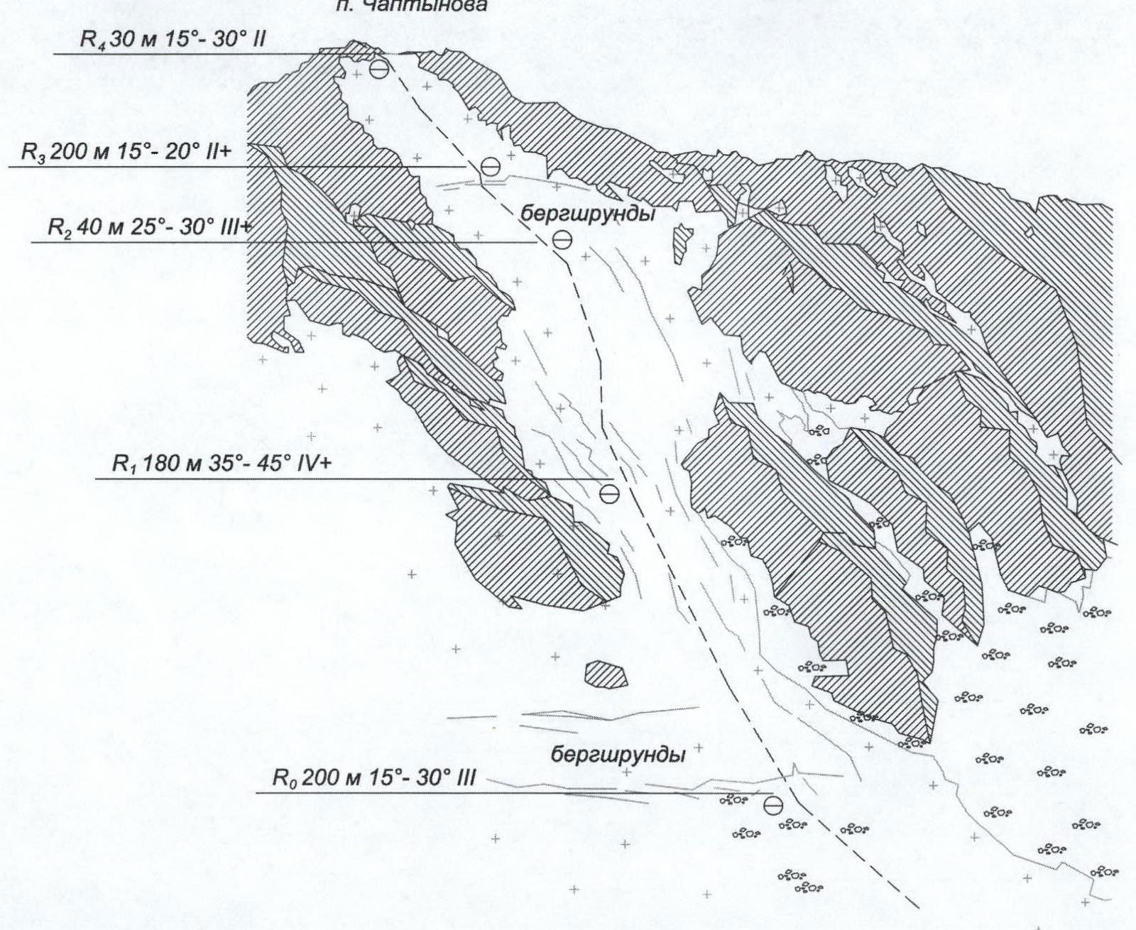
Route map
Route to Chaptynova peak via the direct line of the northern slope (ice route). Approximately 3A category.
Description of route sections: Chaptynova peak R4 30 m 15–30° II R3 200 m 15–20° II+ R2 40 m 25–30° III+ R1 180 m 35–45° IV+ Bergschrund R0 200 m 15–30° III Bergschrund
View from Syurpriz peak

View from the glacier
From the camp, located at the confluence of the Karakabak river and the river from the cirque of Karakabak peaks, cross the Karakabak river and move along the river that flows in from the right (orographically), then along the moraines in the direction of Chaptynova peak for 1.5–2 hours to the glacier, then across the center of the glacier to the bergschrund. Cross the bergschrund simultaneously. Then move on the ice. 200 m (5 ropes of 40 m) steepness: 15–30°, simultaneous movement with protection through ice screws. 180 m (40 m + 50 m + 40 m + 50 m) — steepness: 35–45°, movement on fixed ropes, protection through ice screws. 40 m (1 rope) steepness ~25–30° with crossing the bergschrund, simultaneous movement with protection through ice screws. 200 m (5 ropes of 40 m) steepness: 15–25°, simultaneous movement with protection through ice screws. Rocky section: simultaneous movement to the summit ~20–30 m. Descent is made by the same route.
Route safety assessment
The route is not prone to rockfall. Falling rocks are possible from the rocks on the right and left. No rockfall is expected in the center. During the ascent, individual rocks fell along the ice gully next to the rocks on the right, but did not exit the gully. On the left and in the center, no rocks fell.