Passport
- First ascent category.
- Altai, Severo-Chuysky ridge, Karakabak gorge.
- Mt. Generalissimus Suvorov via south-west ridge.
- Proposed category 1B difficulty (first ascent).
- Height 3150 m, elevation gain 480 m, length 1200 m, average slope 22°.
- Moving time 9 hours (from camp to camp).
- No overnight stays necessary.
- Climbing team: Dumayskaya E. L., 1st sports category. Semenov S. A., 2nd sports category.
- Coach Drakin A. V., 1st category, no. 68.
- Ascent date August 21, 1999.
- Organized by Altai Regional Alpine Federation.

Brief Description of the Area
The Karakabak River is a left orographic tributary of the Mazhoy (Maashey) River. Different maps show various names for this river. Both Mazhoy and Mashey appear on topographic maps, with Mazhoy being more common. Maashey is mostly found on tourist maps. Access to the area is via the village of Chibit. In Chibit, turn off the Chuya Highway and drive along the Chuya River for 15 km to the confluence with the Mazhoy (Maashey) River, where a car bridge crosses the Chuya. Cross the Chuya, overcome a steep, long climb with hairpin turns, and drive along the Mazhoy (Maashey) River valley to the upper zimovye (winter settlement). There is no road beyond this point. The section from Chibit village to the upper zimovye can only be traversed by a high-clearance vehicle. From the zimovye, the upper reaches of the Karakabak River can be reached by following the Karakabak River, ascending a forested slope, or by following a small ridge separating the Karakabak River valley from a swampy plateau. Above the forest zone, a series of lakes is located along the river. The approach to the lower lake takes 2-3 hours from the upper zimovye. An expedition of climbers from Barnaul set up a base camp near the upper zimovye and an advanced camp above the second lake. All ascents were made from the advanced camp. The area is rarely visited by climbers, although most high and prominent peaks have been climbed. Cairns with notes have been left on many peaks. Climbs were made in 1976 and 1982 by climbers from the Lokomotiv sports society from Novosibirsk and Barnaul. It appears that no reports were submitted to the classification commission, although a report was submitted for the route to the summit of Mt. Achkasova.
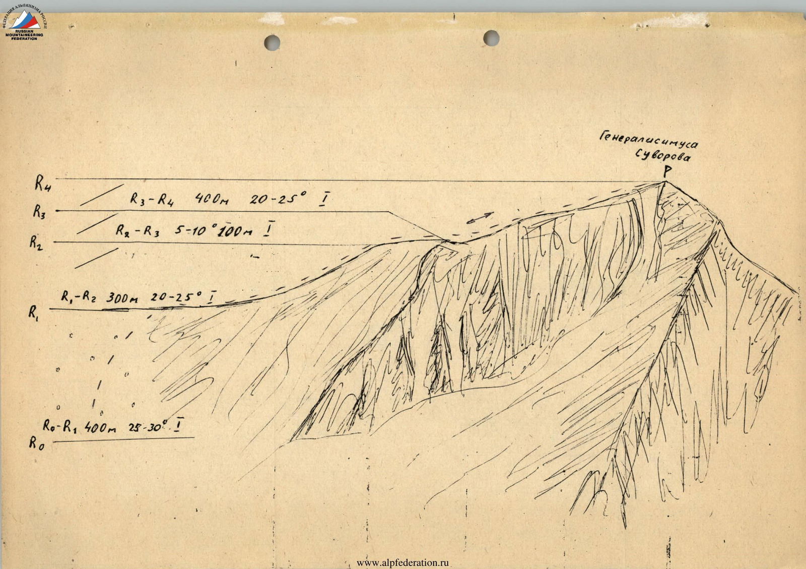
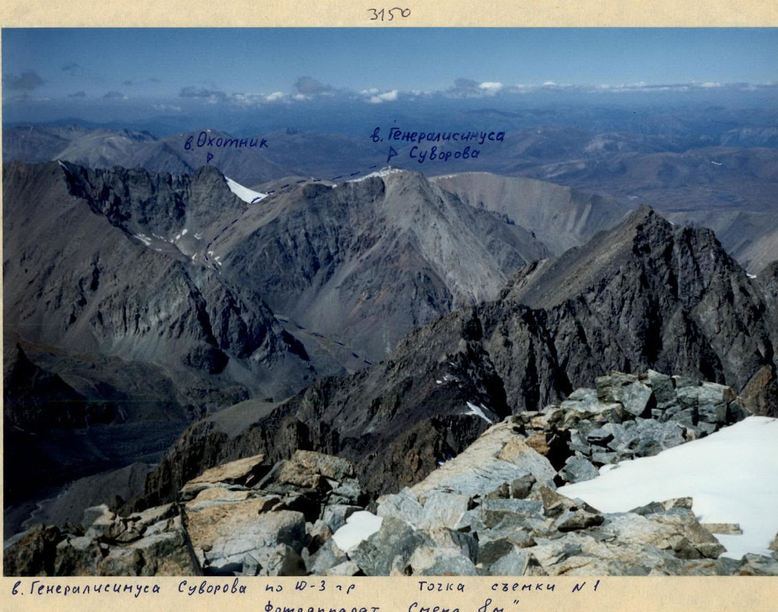
Mt. Generalissimus Suvorov
via south-west ridge.
From the advanced camp, located above the second lake on the Karakabak River, move along the left orographic bank, bypassing the third lake to a stream flowing from under the slopes of Mt. Generalissimus Suvorov.
Ascend the stream, overcoming several moraine steps. The scree is coarse. The stream valley leads to the col between Mt. Ohotnik and Mt. Generalissimus Suvorov.
The approach takes 2-2.5 hours.
Ascend to the col via medium and fine scree. The western ridge is not technically difficult. There is a minor rise in the ridge with a cairn and a note indicating that this is the summit of "Unknown Soldier".
The western ridge leads to the summit of Mt. Generalissimus Suvorov. Movement is simultaneous along the entire route.
Descent is via the ascent route.