
39
REPORT ON THE ASCENT OF THE USSR CHAMPIONSHIP IN THE CLASS OF "TECHNICALLY COMPLEX" CLIMBS
Peak MaaShey-Bash via the northwest wall. Altai. (5B + 1 - approximately)
Dedicated to the 50th anniversary of the Soviet State.
Team of the Leningrad City Council of the Union of Sports Societies and Organizations of the RSFSR.
1. Geographical description and sporting characteristics of the climb object.
Peak MaaShey-Bash (4200 m) is the highest point of the North-Chuya mountain node ("Bish-Murdu"), one of the most picturesque regions of Mountainous Altai. The node is formed by the North-Chuya ridge, stretching in a latitudinal direction between the rivers Chuya to the north, Karagem and Chegan-Uzun to the south. The MaaShey-Bash massif is located in the western part of the ridge. Its northern slopes give rise to the MaaShey glacier, the second longest in Altai (10 km). The MaaShey-Yul river flows out of the glacier and runs north until it meets the Chuya. To the east of MaaShey, the North-Chuya ridge is composed of the peaks Karagem, Bars, Tamma, Burvestnik, UPI, and Snezhnaya. The northern spur of the ridge at peak Burvestnik separates the MaaShey and Ak-Tru glaciers.
MaaShey-Bash drops to the north with severe walls that capture the attention of climbers. The classified route (4B) to the summit follows the northern ridge, which separates the Left and Central MaaShey glaciers. Routes on the northeast wall (snow and ice, with small rocky outcrops) are objectively hazardous due to the hanging snow cornices above. Their formation is likely facilitated by heavy precipitation and strong southwest winds this year.
To the northwest, the MaaShey wall drops with a steep icefall, above which at least 3 routes of the highest difficulty category are discernible. They pass through rocky outcrops of island and bastion character on a steep ice and snow wall. The total height of the NW wall from the Left MaaShey glacier to the summit is about 1200-1300 m. One-third of the height is the icefall.
Routes on MaaShey-Bash from the north via the wall have been entered several times in the USSR Climbing Championships.
Not уступая северо-восточной стене по сложности, северо-западная стена не имеет снежных карнизов и безопасна для прохождения в сложных метеоусловиях.
Not less complex than the northeast wall, the northwest wall lacks snow cornices and is safe to traverse in challenging weather conditions.
2. Climbing conditions in the area.
Weather.
Weather significantly impacts climbers' plans in Altai. Mountainous Altai is almost at the center of the vast Eurasian continent, on the western edge of the belt of mountains in southern Siberia, making it the northernmost climbing region in the USSR. This determines the climatic peculiarities of the Altai mountain regions.
Here, three climate types converge: the West Siberian continental-cyclonic with significant atmospheric precipitation, the Mongolian continental anticyclonic, and the Central Asian desert and semi-desert climate, dry but with a large moisture reserve in the upper air layers. For the latitudes where the region is located, western and southwestern air currents prevail, which are stable and more pronounced at heights above 1000-2000 m. These air currents bring a lot of moisture. The Katunsky, North-Chuya, and South-Chuya ridges receive the most moisture in Altai. The glaciers of these ridges receive at least 2000-2500 mm of precipitation annually (almost as much as in Colchis!). Characteristic of Mountainous Altai is the low position of the snow line and the proximity of alpine meadows to it. However, western air masses do not entirely determine the climate. Over the mountains, their own air forms; colliding with plain air masses, it contributes to cyclone formation. Additionally, mountain ridges, standing in the way of air flows, cause them to rise, accompanied by cooling and condensation of water vapor. Therefore, even the dry air of Central Asia can produce precipitation in the Altai mountains. Most precipitation falls in Mountainous Altai in the second half of summer. The average annual temperature in the high mountain zone is -7°. The average July temperature at the upper forest boundary is 8°, at heights of 4000 m - 0°.
All this shows that when organizing a serious ascent in the Altai mountains, one should not rely on favorable weather: a diagram of weather conditions in the North-Chuya Mountains from July 25 to August 25, 1967 (our stay period) confirms this opinion.
Accessibility of the MaaShey-Bash area (character of approaches).
The MaaShey-Bash area can be reached from the Ak-Tru alpine camp through the MaaShey pass (2nd category difficulty). In poor weather conditions, the 10-12 hour journey can stretch to 3 days: on both sides of the pass, closed glaciers are riddled with crevasses.
Another option is to bypass via the "skotimpport" trail to the north, ascending to the upper reaches of the MaaShey glaciers along the MaaShey-Yul river valley. This tourist route through the taiga and moraines is, of course, longer but simpler and can serve as a caravan route - horses can be led to the base camp.
3. Reconnaissance.
Before the reconnaissance, consultations were held with instructors from the camp. The first reconnaissance sortie of the entire group (leader BUDANOV P.P., participants: USTINOV Y.K., IL'INSKII G.Y., KONOPLEV K.A., IL'IN A.A., BORODIN R.A., PEROVA Z.V.) from the "Ak-Tru" camp on the second day after arrival (July 26, 1967) had several objectives, namely:
- Active acclimatization of all expedition participants;
- Inspection and observation of wall routes on MaaShey-Bash, determining their technical condition at the moment (snow cover and avalanche danger of slopes, character of rocks, rockfall danger, change of route with changing weather conditions, choosing the optimal path to the summit according to the application.
It was also necessary to determine the character of approaches to the summit, possibilities for transporting expedition cargo, and organizing intermediate, base, and assault camps on the way to it.
To this end, the reconnaissance route had a circular character: "Ak-Tru" camp — MaaShey pass — Central and Left MaaShey glaciers — MaaShey-Ol valley — "skotimpport" trail — "Ak-Tru" camp transfer — Ak-Tru alpine camp.
The sortie was successful. The set tasks were solved, and the entire group returned to the camp on August 1, 1967.
The reconnaissance dispelled our hopes for good weather in the MaaShey area (see the certificate of the rescue service chief). Except for a day and a half, the entire 6-day hike was in variable rain and snow. Our meteorological conclusion: on both sides of the MaaShey pass, an hour of precipitation follows every 30-40 minutes.
After thorough reconnaissance, it was decided to make the ascent via the Northwest wall (alternative option), as a safer, more logical route leading to the summit.
The last green pocket of the lateral moraine of the Left MaaShey glacier proved to be an exceptionally convenient location for the base camp. The height of this location allowed not to organize a special assault camp, and the good alpine meadows on the slopes allowed keeping pack animals here.
It was decided to transfer expedition cargo from the "Ak-Tru" transfer base by machine along the "skotimpport" trail (only a tractor could pass) and then by caravan up the MaaShey-Yul gorge as far as the animals could go.
Rest after the reconnaissance hike and preparation for the ascent took 5 days.
On August 7, 1967, a group consisting of:
Main composition
- BUDANOV P.P. - Master of Sports, Honored Coach of the USSR - Team Captain
- IL'INSKII G.Y. - Master of Sports - Deputy Team Captain
- KONOPLEV K.A. - Master of Sports - Participant
- USTINOV Y.K. - "—" - "—"
- IL'IN A.A. - CMS - "—"
Supporting staff
- BORODIN R.A. - Classified climber - Senior observer-radioman
- PEROVA Z.V. - "—" - Doctor
- POPOVA L. - "—" - Observer
- ZYUZIN V. - "—" - "—"
- KONDAKOV V. - "—" - "—"
left the "Ak-Tru" transfer base for the MaaShey gorge.
25 km of off-road terrain from the Ak-Tru gorge to the MaaShey-Yul gorge: they moved on a tractor with a trailer.
Due to B.B. KLETSKO's participation in the anniversary ascent on Peak LENIN, he was withdrawn from the team composition. On August 8, 1967, a shuttle transfer of cargo began along the MaaShey gorge by the participants with two pack horses.
By August 13, 1967, all cargo, participants, and animals were at the camp by the Left MaaShey glacier. It is worth noting that the upper part of the path along the gorge had never been visited by pack caravans before. The caravan handlers were the expedition participants themselves. On this path, they had to make a trail (about 5 km) for the pack animals to ascend.
Due to the inability to establish planned radio communication with the Ak-Tru alpine camp, it was decided to leave the horses in the base camp until the end of the ascent.
The start of the assault was scheduled for August 14, 1967. It was decided to move in a foursome (1 tent) in pairs: P. BUDANOV - A. IL'IN, Y. USTINOV - K. KONOPLEV. IL'INSKII remained below.
During the ascent, communication between the assault group and the observation group in the base camp was carried out via the "Nedra" P-2 radio. Radio communication was backed up by flares.
Ascent diary
(Sections of the route see in photos and profile diagrams).
August 13 - Setting up the camp. August 14 - Departure for the ascent. On this day, the pair processed the lower snow and ice part of the route - the icefall (R1). August 15 - Layover in the camp due to bad weather. August 16 - Continuing the route and part of the wall from the icefall to the first rocky outcrop. Overnight in a hollow (R2). August 17 - Passing the section of the wall from the hollow to the first gendarme ("finger"). Due to bad weather and lack of overnight locations - descent into the hollow. Overnight (R3). August 18 - Passing the rocky bastion (second gendarme). Overnight on the bastion (R4-R5). August 19 - Passing the upper part of the wall. Summit at 13:00. Descent along the Northern ridge. Overnight under the saddle between the Rocky peak and MaaShey (R6-R7). August 20 - Descent to the base camp.
All days had very early departures - 3-4 am.
Overall assessment of the actions of the assault team participants.
A long-established team with a large number of serious joint ascents significantly facilitates the task of the ascent itself. Despite unfavorable weather conditions this year (thaw with snowfalls), the most optimal tactical variant was chosen, which fully justified itself:
- Very early departures at 3-4 am,
- Separate work of the pairs,
- Leaving well-marked belay points on the route (pitons, loops),
- And on particularly difficult sections - cordelettes for a possible forced descent.
The entire group worked cohesively, with the pair of Masters of Sports KONOPLEV - USTINOV performing particularly well; Andrey IL'IN, included in the group for the first time as an equal team member, performed well.
Remarks
- Abundant snow facilitated the passage of icy sections of the route and allowed bypassing unpleasant slabs of the first outcrop on snow. However, it also complicated the passage of rocky sections.
- Drill pitons were not used on the route.
- Considering all the above, and comparing the route with previously made ascents, the group believes that the route to the summit of peak MaaShey-Bash via the Northwest wall of 5B category will be one of the most interesting routes in this area.
Team Captain - Coach Honored Coach of the USSR, Master of Sports of International Class (BUDANOV P.P.)
Table of main characteristics of the ascent route
| Passed sections | Average slope of the section | Height of the section | Characteristics of sections and conditions of their passage | Number of pitons driven |
|---|---|---|---|---|
| By technical difficulty | By method of overcoming | |||
| R1 | 50° | 400 m | Icefall | Alternating, ice axe-pitons |
| R2 | 60° | 200 m | Ice | Alternating, pitons, steps |
| R3 | 60° | 150 m | Snow | Alternating, ice axe |
| R4 | 60° | 70 m | Snow-covered rocks | Alternating, pitons |
| R5 | 75° | 250 m | Snow-covered rocks, ice | Pitons, ledges |
| R6 | 50° | 150 m | Snow-covered rocks, ice | Pitons, ledges |
| R7 | 45° | 700 m | Snow, ice, ridge | Ice axe |
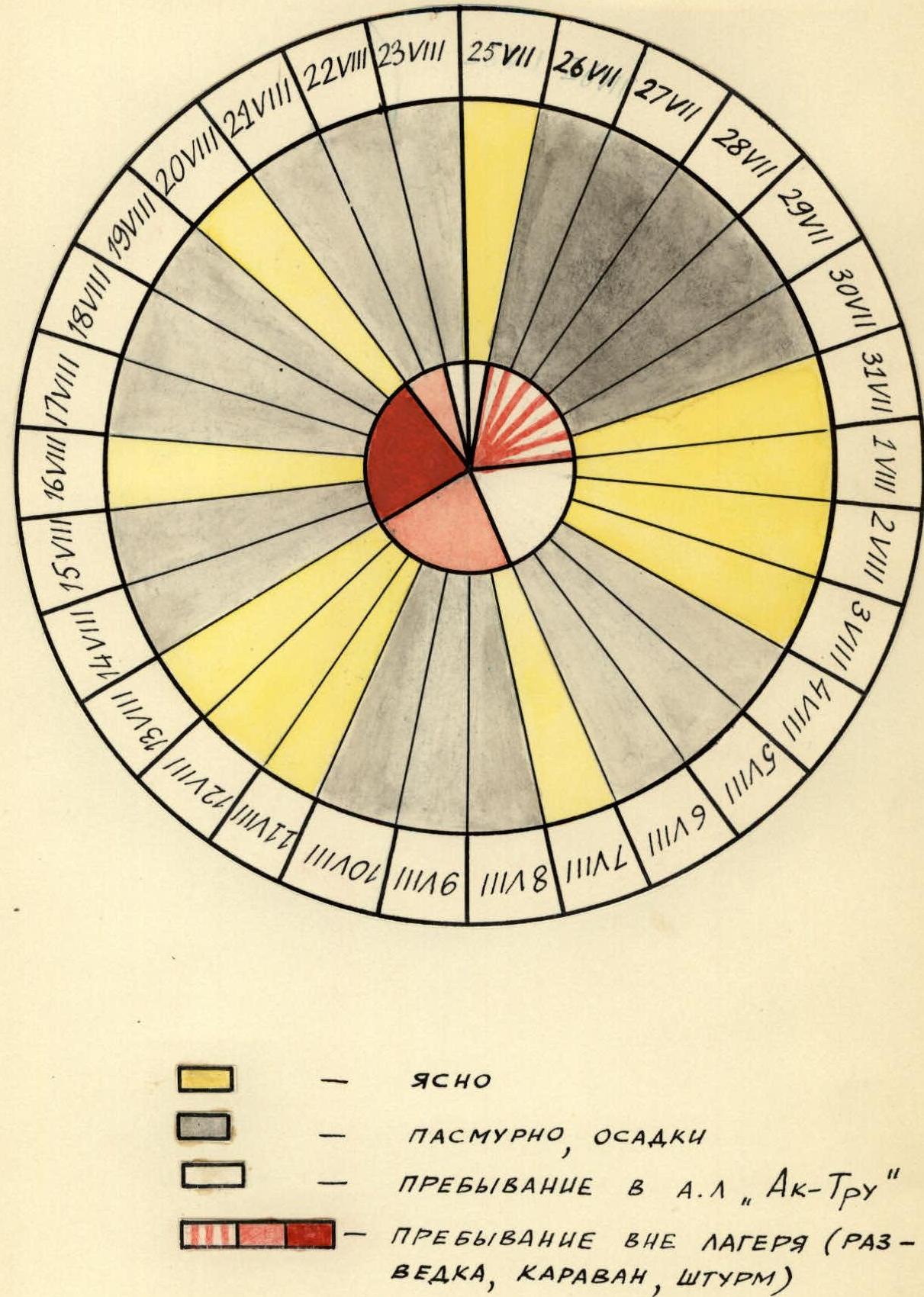
Diagram of weather conditions from 25.07.1967 to 23.08.1967
- CLEAR
- CLOUDY, PRECIPITATION
- STAY IN ALPINE CAMP "Ak-Tru"
- STAY OUTSIDE THE CAMP (RECONNAISSANCE, CARAVAN, ASSAULT)

