
Passport
- Category — first ascent.
- Altai, Severo-Chuysky Ridge, Karakabak gorge.
- G. Zhukov Peak via north-eastern ridge.
- Proposed category 3B (first ascent).
- Height 3100 m, elevation gain 550 m, length 1100 m, average slope 30°.
- Pitons — 9 wired cams.
- Climbing time 11 hours (from camp to camp).
- No need for overnight stay.
- Team: Drakin A. V. — Candidate Master of Sports Okhtemenko I. N. — 1st sports category
- Coach Drakin A. V. — 1st category No. 68.
- Ascent date August 27, 1999.
- Organisation — Altai Regional Alpine Federation.
G. Zhukov Peak

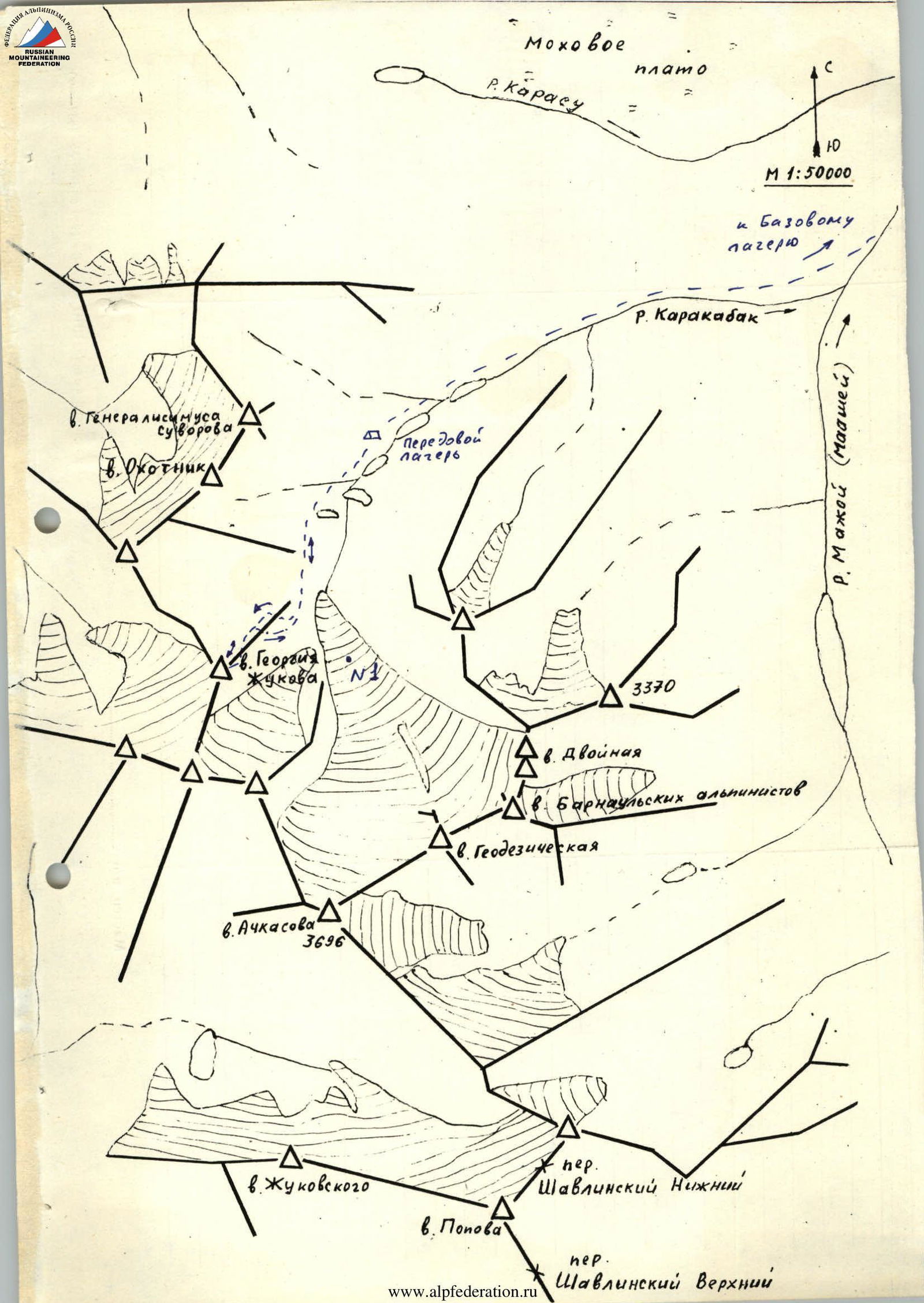
Brief Description of the Area
The Karakabak River is a left orographic tributary of the Mazhoy (Maashey) River. Different maps show various names for this river. Mazhoy and Mashey can be found on topographic maps, with Mazhoy being more common. Maashey is predominantly found on tourist schematic maps.
Access to the area is via the Chuy tract to the village of Chibit. In Chibit, turn off the Chuy tract and drive along the Chuya River for 15 km to the confluence with the Mazhoy (Maashey) River. Here, a car bridge crosses the Chuya River. Cross the Chuya, overcome a steep incline with hairpin bends, and drive along the Mazhoy (Maashey) River valley to the upper winter settlement. Beyond this point, there is no road. The section from Chibit village to the upper winter settlement can only be traversed by a high-clearance vehicle. From the winter settlement, one can reach the upper reaches of the Karakabak River either by walking along the Karakabak River, ascending a forest-covered slope, or via a small ridge separating the Karakabak River valley from a swampy plateau. Above the forest zone along the river lies a series of lakes. The approach to the lower lake takes 2–3 hours from the upper winter settlement.
An expedition of climbers from Barnaul set up a base camp near the upper winter settlement and an advanced camp above the second lake. All ascents were made from the advanced camp.
The area is rarely visited by climbers, although most of the high and prominent peaks have been ascended by climbers. Cairns with notes have been left. Climbers from the Lokomotiv Sports Society (DSO) from Novosibirsk and Barnaul made ascents in 1976 and 1982. Apparently, no reports were submitted to the classification commission, except for the route to Achkasova Peak.
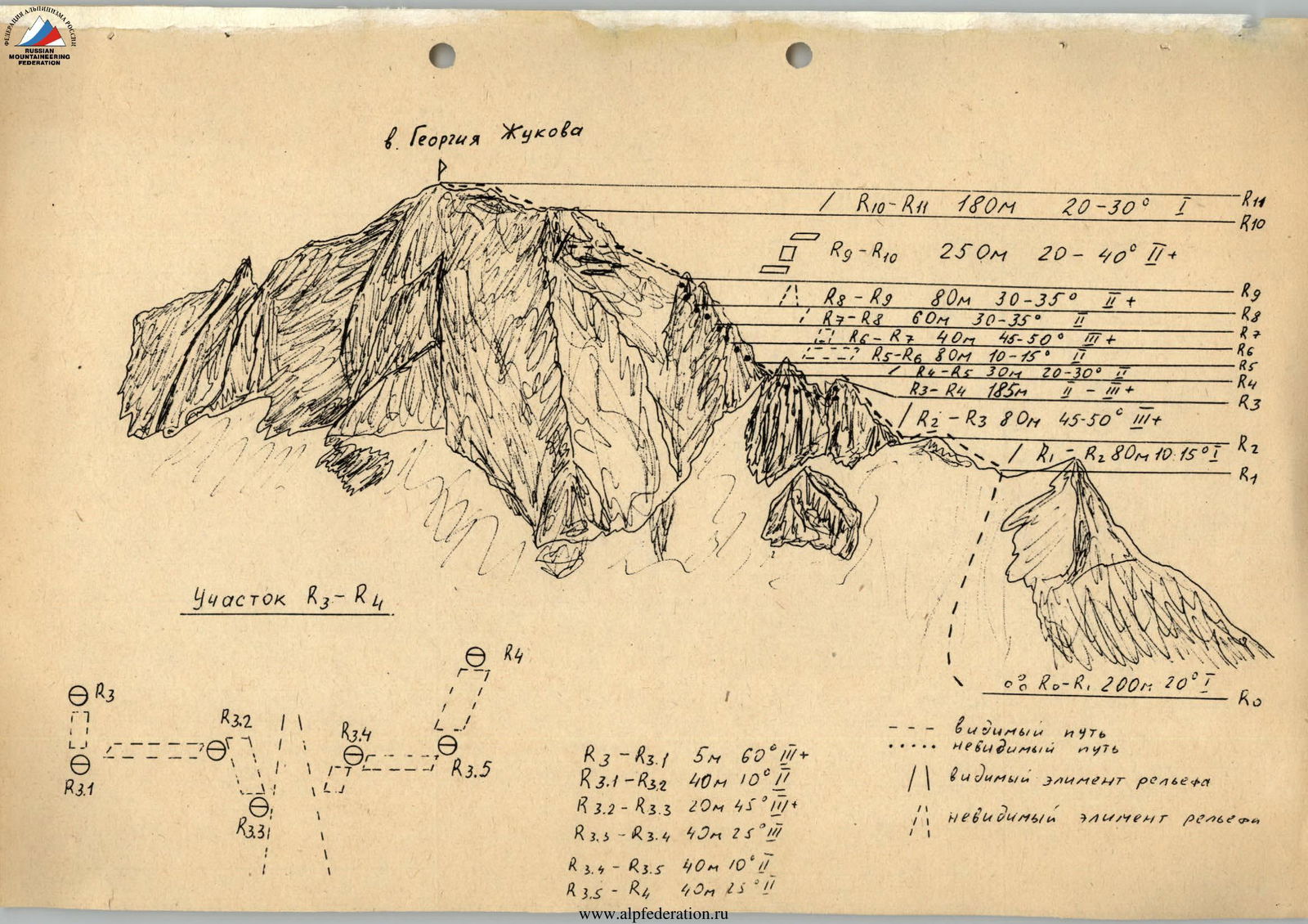
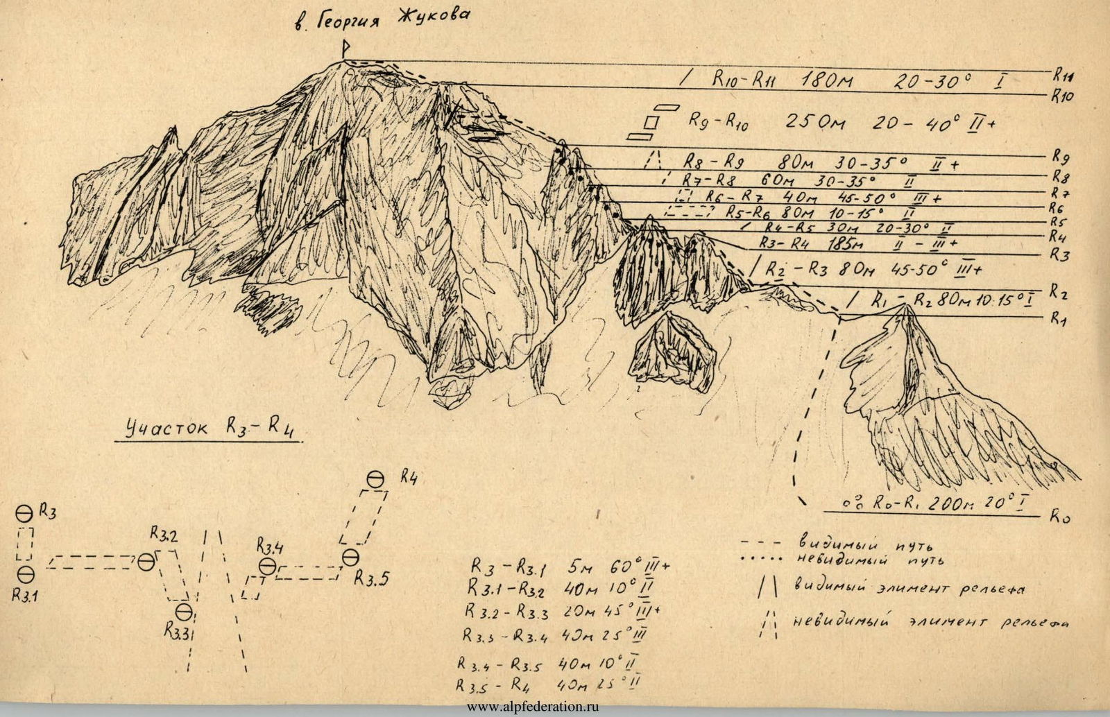
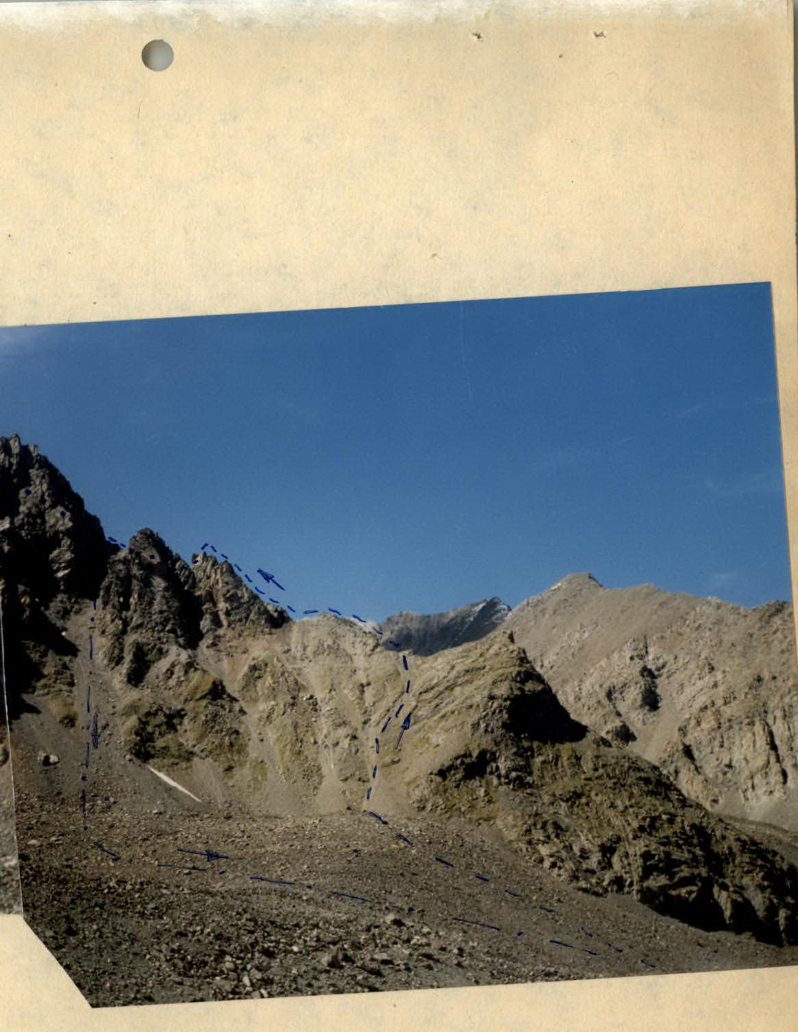
G. Zhukov Peak via North-Eastern Ridge
From the advanced camp, located above the second lake on the Karakabak River, move along the left (orographically) bank, bypassing the third and fourth lakes, to a moraine ridge blocking the river valley. Ascend the moraine ridge and proceed along the moraine to the start of the north-eastern ridge of G. Zhukov Peak. Bypass the lower gendarme on the left and ascend to a col in the ridge via scree. The approach takes 2–2.5 hours.
Follow a straightforward ridge to the first gendarme. The ascent involves two 40 m steps. Climbing category 3, with 5–6 m of challenging climbing at the top. Without reaching the tip of the gendarme, descend to a ledge on the right via a complex inner corner (5–7 m). Traverse the gendarme on the right via the ledge and approach a couloir leading down from the col between the first and second gendarmes. With careful belaying, descend to the couloir via a narrow ledge, cross it, and ascend a wet slab to an osypnaya ledge to the right of the second gendarme. Bypass the second gendarme on the right via the ledge and ascend destroyed rocks to a col behind the gendarme.
The third gendarme is also bypassed on the right. Initially, follow the ridge to a ledge going right. Then, traverse the ledge to a rock wall. The rock wall is challenging and requires piton belays. The length is 40 m. The wall leads to the ridge. Ascend the ridge towards the col behind the gendarme until reaching a small couloir. Cross the couloir and ascend the right-hand side of the couloir to an osypnoy slope leading to a col behind the gendarme. Climbing is alternating, with belays via outcrops.
The final rock ascent is bypassed on the left via a series of ledges and short walls. Climbing is alternating, with belays via outcrops.
The further ascent to the summit follows a straightforward rocky ridge, with a snowy slope near the top.
The descent to the col between the second and third gendarmes follows the ascent route. Then, descend down a narrow, steep osypnoy couloir to the right.