Heroes of Altai peak via the northwestern slope
Barnov S.I. Altai, Severo-Chuysky Ridge 1.2
Passport
- Category: first ascent.
- Altai, Severo-Chuysky Ridge, Karakabak gorge, 1.2
- Heroes of Altai peak, via the northwestern slope, ice and snow.
- Proposed — category 4A difficulty, first ascent.
- Elevation gain: 480 m; length – 1050 m.
Length of category V sections – 15 m. Average slope:
- main part of the route – 35–40°
- entire route (from the bergschrund) – 30–35°.
-
Pitons used on the route: ice screws – 24.
-
Team's travel time:
- 4 h 45 min from the glacier to the summit;
- 8 h 30 min from the glacier to the glacier;
- 16 h 30 min from the base camp to the base camp.
-
Overnight stays — none.
-
Team members: Barnov Sergey Ivanovich, 1st sports category; Komissarov Dmitry Alexandrovich, 3rd sports category.
-
Coach: Tumyalis Vladimir Vitalius, II category.
-
Departure from base camp: 6:00, August 22, 2000. Start of the route: 10:00, August 22, 2000. Reaching the summit: 14:45, August 22, 2000. Return to base camp: 22:30, August 22, 2000.
-
Organization: training camp from Barnaul.
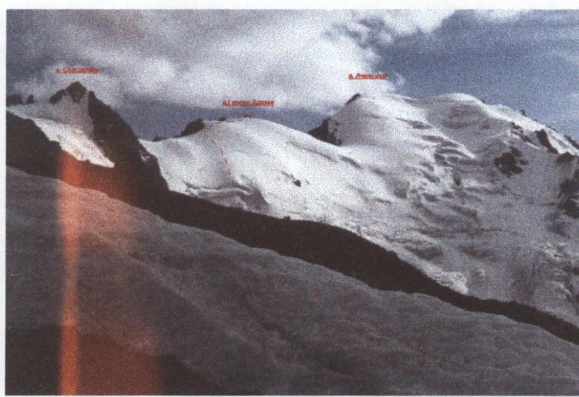
Heroes of Altai peak, via the northwestern slope, photo point #1
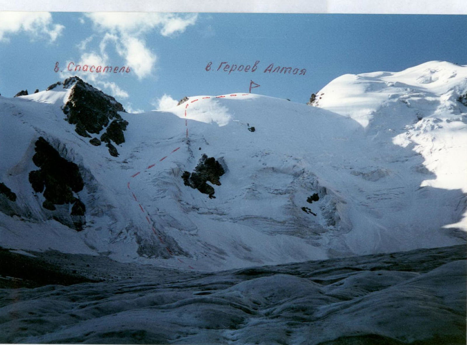
 Heroes of Altai peak
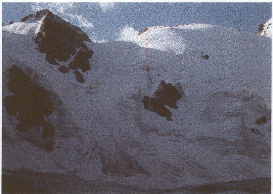
 Route to Heroes of Altai peak via the northwestern slope (ice). Approximately category 4A difficulty.
View from the glacier

View from Chaptynov peak
View from under Geodesicheskaya peak
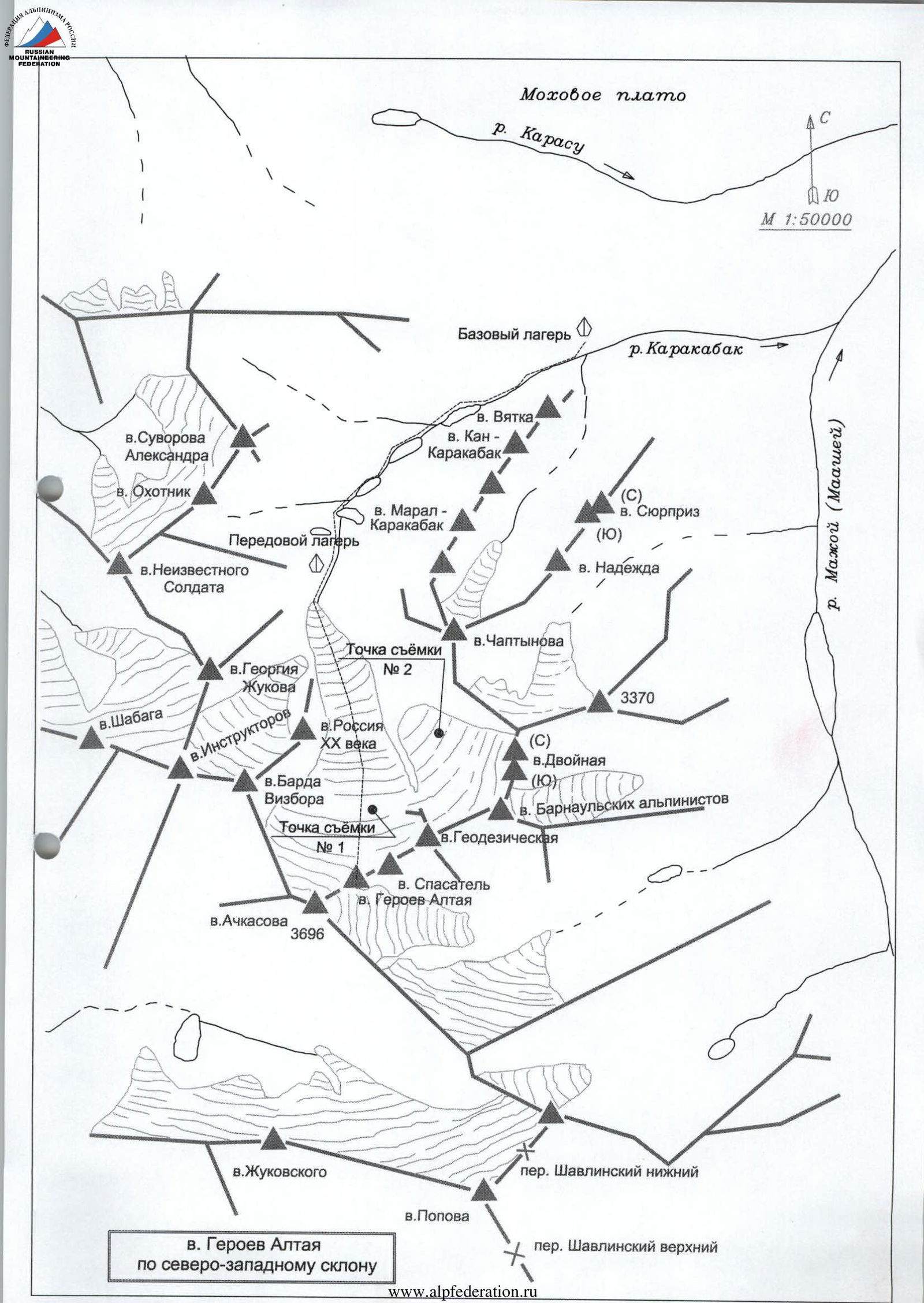
From the camp, located at the confluence of the Karakabak river and the river from the cirque of Karakabak peaks, move along the left orographic bank, bypassing the lakes, to the moraine rampart blocking the river valley. Ascend to the moraine rampart, proceed along the river through two river expansions to the glacier tongue. Approach the northwestern slope of Heroes of Altai peak via the glacier. The approach from the camp takes 3–3.5 hours, from the forward camp near the last river expansion – 1–1.5 hours.
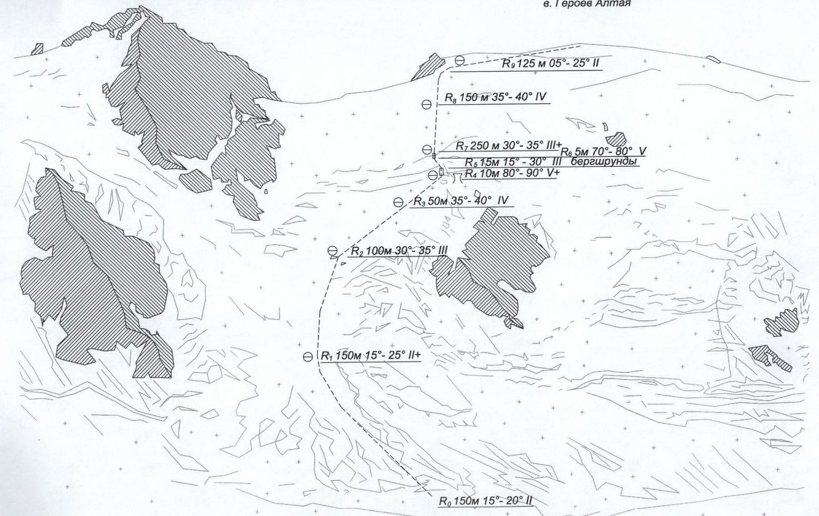
Movement on ice:
- Along the glacial stream channel for 150 m (3 ropes of 50 m) — slope: 15–20°, simultaneous movement with protection via ice screws.
- In the direction of rocks to the right — upwards for 150 m (3 ropes of 50 m) — slope: 15–25°, movement on fixed ropes, protection via ice screws.
- In the direction of the break in the bergschrund with a grotto above the rock outcrop to the right — upwards for 150 m:
- 2 ropes of 50 m — slope: 30–35°,
- 1 rope of 50 m — slope: 35–40°, movement on fixed ropes, protection via ice screws.
A large ice plateau with a grotto allows preparation for overcoming the difficult section.
- Ice face 10 m, slope: 80–90°, several crevices.
- Another ice face 5 m, slope: 70–80°.
After this, move in the direction of the rock "tooth" beyond the inflection:
- 250 m (5 ropes of 50 m) — slope: 30–35°, movement on fixed ropes, protection via ice screws.
Before reaching the ridge, it pulls to the left towards a saddle, but moving there is pointless, as the ascent from the saddle is not easier and approximately one rope length is lost.
Continue moving in the direction of the rock "tooth":
- 150 m (3 ropes of 50 m) — slope: 35–40°, movement on fixed ropes, protection via ice screws.
Exit onto the ridge near the rock "tooth" — the second pillar. The summit is to the right. Large cornices on the left side; stay to the right.
- 125 m (2.5 ropes of 50 m) — slope: 5–25°, simultaneous movement with protection via ice screws.
Ascent to the summit: broken rocks 10–15 m, simple climbing in crampons (rocks in snow and ice).
Descent via the ascent route.
Route safety assessment
The route is practically free from rockfall hazards. Rockfall is possible from the rocks on the left, so the lower part of the route should be traversed early in the morning. The route variant with an exit to the saddle is more hazardous. During the ascent, no rocks fell.
Icefall onto the route is possible in principle from the bergschrund area at the level of the grotto and to the left and below, although the fractures are minor.
On the approach and especially during the return, it is necessary to move towards the center of the glacier: to the left of Geodesicheskaya peak, large masses of ice have fallen, forming 3 tongues on the glacier.


