9 171
PASSPORT
- Category — first ascent.
- Altai, Severo-Chuysky ridge, Karakabak gorge.
- V. Geodezicheskaya via the northern ridge.
- Proposed category: 3A (first ascent).
- Height 3529 m, elevation gain 480 m, length 950 m, average slope 32°.
- Climbing time 12 hours (from camp to camp).
- Overnight stay — not required.
- Equipment — 8 ice screws.
- Team leader
| Drakin A. V. | CMS | |
|---|---|---|
| team members | Vinnikov K. E. | 1st sports category |
| Gorbova G. A. | 3rd sports category | |
| Markin N. L. | 1st sports category | |
| Okhtemenko I. N. | 2nd sports category | |
| 10. Coach | Drakin A. V. 1st cat. | № 68. |
| 11. Climbing date | August 24, 1999 |
- Organization — Altai Regional Alpinism Federation.

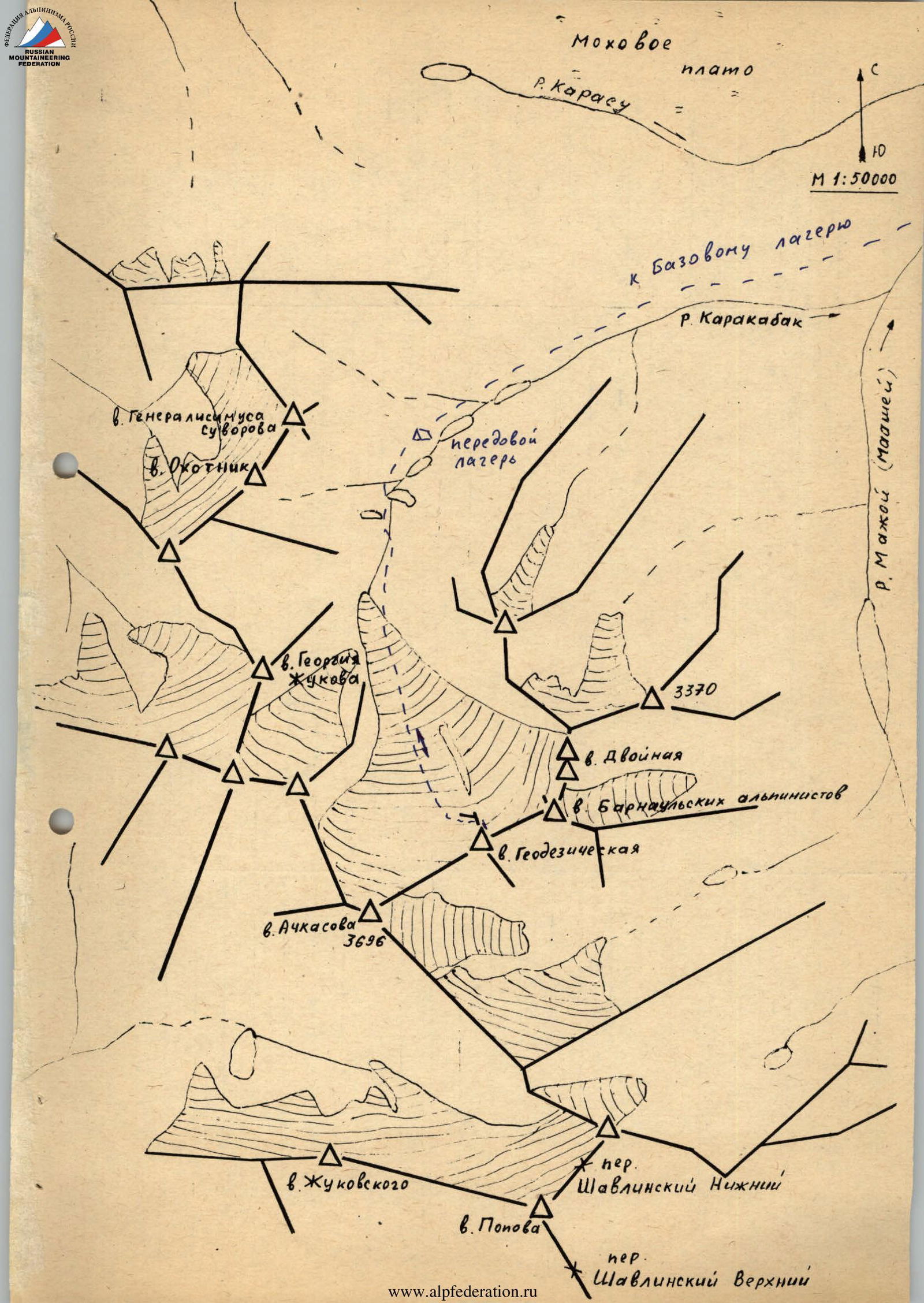
Brief description of the area
The Karakabak River is a left orographic tributary of the Mazhoy (Maashey) River. Different maps may feature various names for this river. Mazhoy and Maashey can be found on topographic maps, with Mazhoy being more common. Maashey is predominantly used on tourist maps.
To reach the area, follow the Chuy tract to the settlement of Chibit. In Chibit, turn off the Chuy tract and continue along the Chuya River for 15 km until reaching the confluence with the Mazhoy (Maashey) River. At this point, there is a vehicular bridge across the Chuya. Cross the Chuya, overcome a steep incline with serpentine roads, and drive along the Mazhoy (Maashey) River valley to the upper wintering hut. Beyond this point, there is no vehicular road. The section from Chibit to the upper wintering hut can only be traversed by a high-clearance vehicle. From the wintering hut, it's possible to reach the upper reaches of the Karakabak River either by following the Karakabak River along a forested slope or by traversing a small ridge separating the Karakabak valley from a swampy plateau. Above the forest zone, along the river, lies a series of lakes. The hike to the lower lake takes 2–3 hours from the upper wintering hut.
An expedition of climbers from Barnaul set up a base camp near the upper wintering hut and an advanced camp above the second lake. All ascents were made from the advanced camp.
The area is infrequently visited by climbers. However, most of the high and prominent peaks have been climbed, as evidenced by cairns with notes. Climbs were made in 1976 and 1982 by climbers from the Lokomotiv sports society from Novosibirsk and Barnaul. Apparently, no reports were submitted to the classification committee, except for the route to the peak named Achkasova.
6. Geodezicheskaya
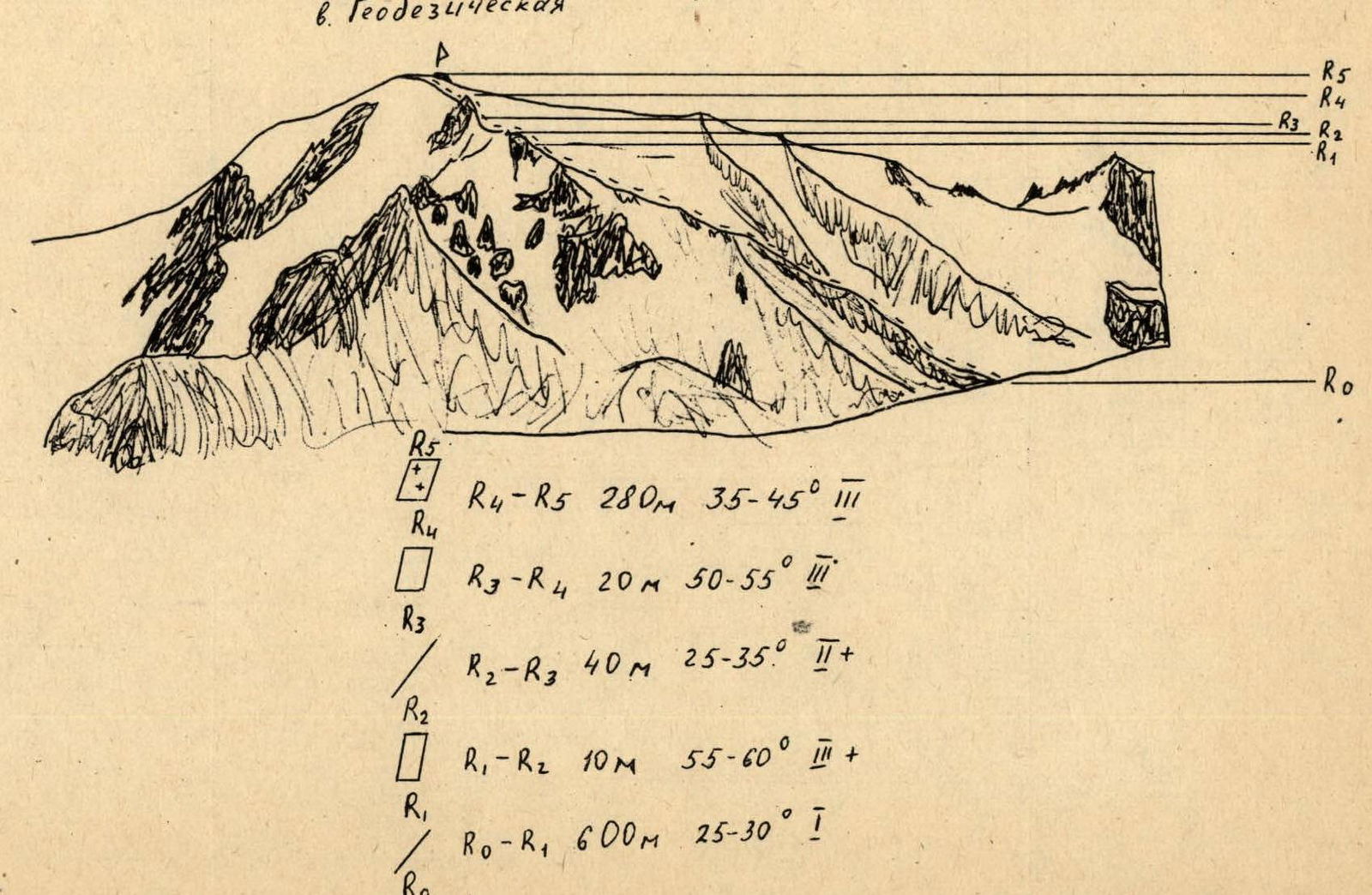
Characteristics of sections:
- R0–R1: 600 m, 25–30°, category 1.
- R1–R2: 10 m, 55–60°, category 3.
- R2–R3: 40 m, 25–35°, category 2.
- R3–R4: 20 m, 50–55°, category 3.
- R4–R5: 280 m, 35–45°, category 2–3.
V. Geodezicheskaya via the northern ridge.
From the advanced camp, located above the second lake on the Karakabak River, move along the left orographic bank, bypassing the third and fourth lakes, to a moraine ridge blocking the river valley. Ascend the moraine ridge and continue along the river to the tongue of the glacier. Approach the northern ridge of Geodezicheskaya peak via the glacier. To the northwest of it, a short, scree-covered spur extends. The approach to the start of the spur takes 2–2.5 hours.
A straightforward ascent up the scree spur leads to two gendarmes on the northern ridge.
The ascent to the first gendarme involves climbing a 20-meter rock wall of moderate difficulty.
Further, the rocky ridge leads to the second gendarme with a 10-meter wall, also of moderate difficulty.
Throughout the two gendarmes, movement is alternating, with protection through protrusions.
After the gendarmes, an ice slope on the northern ridge leads to the summit. The slope is 280 meters long, with a slope angle of 30–35°. Movement is alternating, with protection via ice screws.
Descent is made via the ascent route.


