Ascent Passport
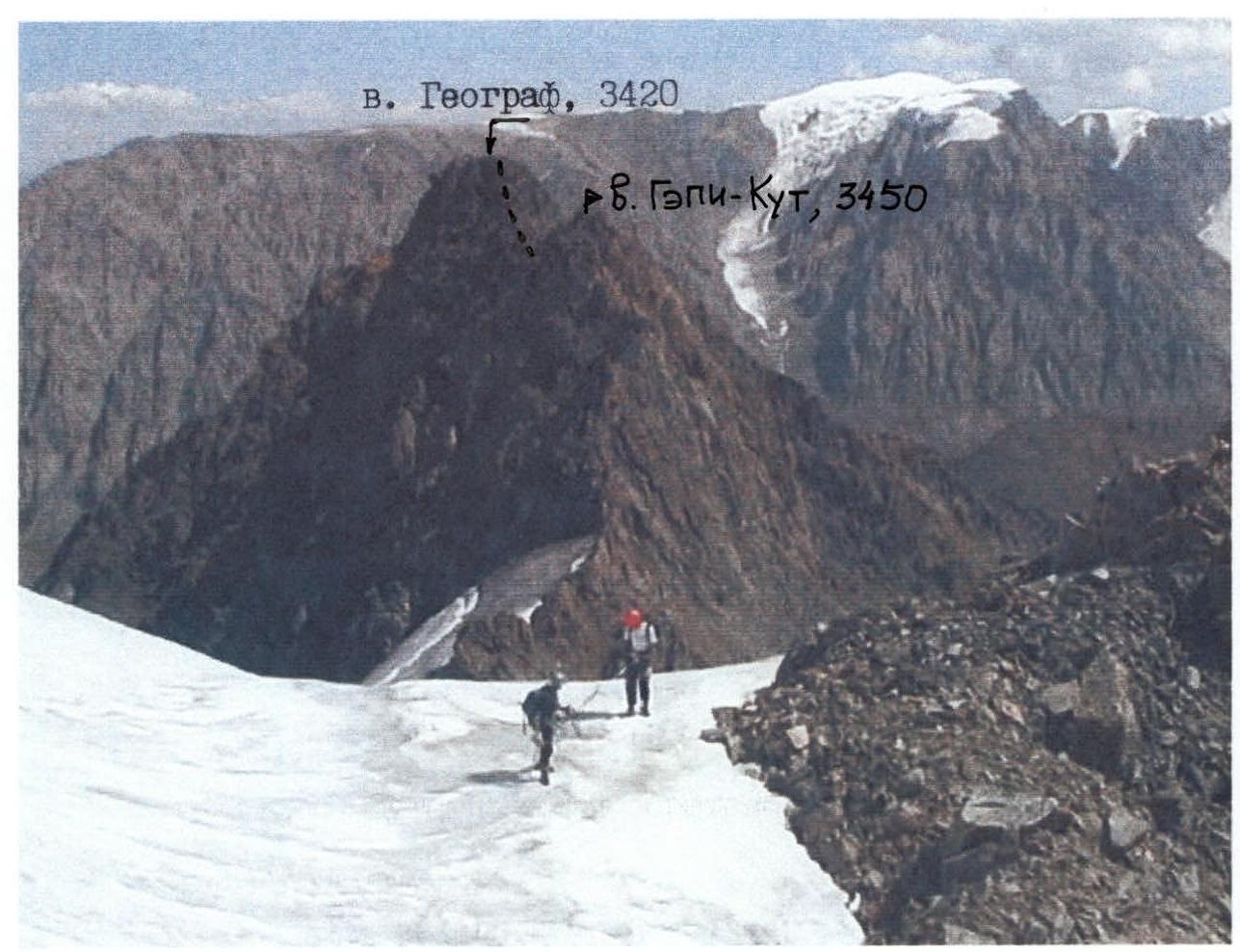
To peak Geograf, 3420 m, 3A cat. diff.
-
Mountainous Altai, Severo-Chuyskiy Ridge, eastern spur of the main ridge between Maashey gorge (Mazhoy, Maashejul) and Shavla River gorge.
-
Peak Geograf, 3420 m, via the Southern slope and Eastern ridge.
-
Proposed — 3A cat. diff., first ascent.
-
Nature of the route — rocky.
-
Height difference of the route: 820 m (by aneroid barometer).
Route length: 410 m. Length of sections:
- 2 cat. diff. — 140 m;
- 3 cat. diff. — 270 m. Average steepness of the main part of the route — 57°.
-
Pitons left on the route — none.
Use of pitons on the route:
- chocks — 8 pcs.;
- pitons — 5 pcs.;
- slings — 2 pcs.
-
Team's travel time: 7 h 00 min.
-
Leader: Ermolaev Yuri Alexandrovich, Candidate for Master of Sports.
Participants: Bekishev M.G., 1st sports category; Sorin A.A., 3rd sports category; Konovalov A.V., 3rd sports category.
-
Coach: Khan Victor Irgonovich, Candidate for Master of Sports.
-
Departure to the route: 6:30 AM, August 13, 2002.
Summit arrival: 11:30 AM. Return to base camp: 3:30 PM.
Description of the Climbing Area
East of the Katunsky Ridge, beyond the Argut River valley, lies the Severo-Chuyskiy Ridge. It stretches from northwest to southeast for 140 km, with a width of 50 km in its western part, gradually narrowing to 20–25 km to the east. The southern and southeastern boundaries of the area are marked by the valleys of the Karagem and Chagan-Uzun rivers. The ridge reaches its highest point in its central part, known as the Bish-Iirdu mountain node, where the main glaciation of the ridge is concentrated. The average height of the ridge here is about 3600 m, and several peaks exceed 4000 m (Maashey-bashi — 4173 m, Akturu — 4075 m).
The passes of the ridge are diverse but share a common pattern — the northern and northeastern slopes of the passes are steeper, with higher ascents. The categories of the passes range up to 3B, with the most serious passes being snow-ice in nature. The snow line on the northern slopes is around 2900 m, and on the southern slopes, it is 3100 m or higher.
The orography of the ridge is complex and consists of several roughly parallel ridges with a general west-east direction — these are the Chuyskiy, Shavlinskiy, and Karagemskiy ridges. The Chuyskiy Ridge is located between the Chuya and Shavla rivers, stretching for 60 km in a latitudinal direction from the confluence of the Chuya and Katun rivers to the Eshtykol plateau. The heights of the ridge increase from west to east, with the highest point being 2925 m. Many river valleys and the watershed have trails. The watershed is marshy in some areas.
The Shavlinskiy Ridge is situated between the Shavla and Jungur valleys. At Argut, its height is about 2500 m, rising to the east, and beyond the right tributary of the Jungur river, the Kurundy river, glaciation appears on the ridge. Forests grow only in the river valleys. The most challenging passes and peaks are located in the eastern part of the ridge, which encloses the Shavlinskie mountain lakes in a horseshoe shape.
The average height of the Karagemskiy Ridge, which is the watershed between the Jungur and Karagem rivers, is 3400 m throughout its length. The ridge is covered with small glaciers, the area of which increases towards the center of the node.
All the ridges converge into a single node in the area of the Sказка and Красавица peaks, located in the headwaters of the Shavla River. Further east, the ridge forms a complex system of ridges with developed valley glaciers and several northern and southern spurs, each 20–25 km long. The most significant glaciation is in the upper reaches of the Akturu, Maashey, and Shavla rivers, and on the southeastern slopes — in the headwaters of the Dzhelo and Karagem rivers.
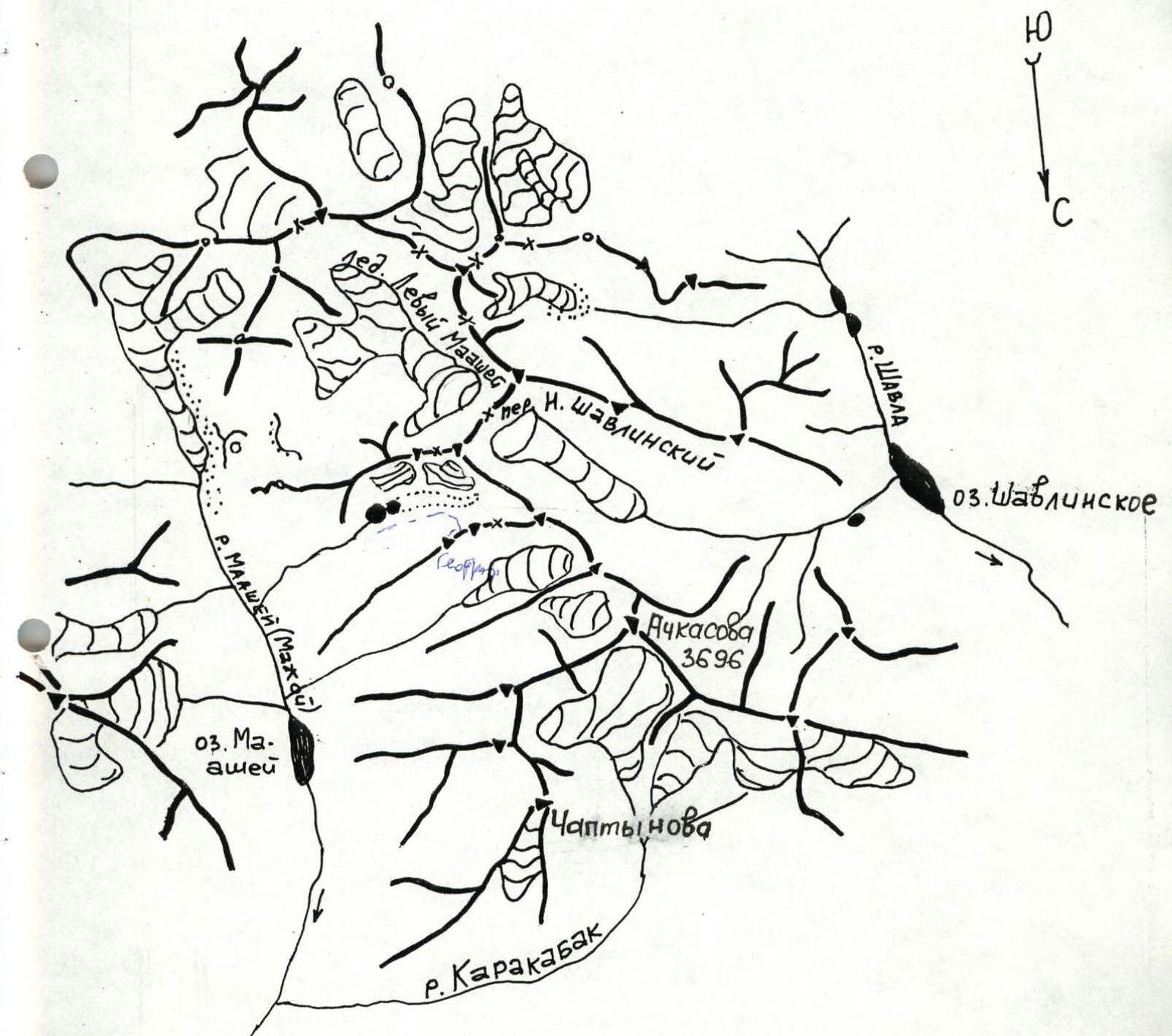
Map of Maashey and Shavla gorges
Description of the Approach to the Geograf Peak Route
Mountainous Altai, Severo-Chuyskiy Ridge, eastern spur of the main ridge between Maashey gorge (Mazhoy, Maashejul) and Shavla River gorge.
From the Chibit settlement to the wooden bridge over the Chuya River at its confluence with the Maashey River, a dirt road follows the orographically left bank. The approach begins from the bridge, initially following a steep hairpin turn, then continuing on a dirt road to the old cattle pen. From the cattle pen, a good trail traverses along the left bank until the Maashey River turns towards its confluence with the Karakabak River. The crossing is made over logs at the confluence. This is a good spot for campsites. From the bridge, it takes ~3 hours. Ascend the orographically left bank of the Maashey River along the trail to Maashey Lake (1.5–2 hours). The lake is bypassed on the right; 30 minutes before reaching the glacier tongue, a campsite known as "Kedrovaya Shishka" (Cedar Cone) is reached. At this campsite, a plaque on a large stone commemorates a deceased tourist named Alena. From the campsite at the confluence of the Karakabak and Maashey rivers to the "Kedrovaya Shishka" campsite, it takes 3–4 hours.
From the campsite, ascend the orographically left tributary of the Maashey River to a waterfall, and by traversing a steep, coarse scree and a grassy slope on the left, exit onto a wide, middle scree slope, which ascends at an angle of 45° along the riverbed towards the "pass" step of the slope. After reaching the top, the river valley becomes a wide, flat plateau. The grassy slopes and riverbed banks are densely overgrown with polar birch ("yortnika", "chira") and are marshy in many places, making movement difficult. The riverbed has branching streams, with many seepages and spring outlets. It is better to cross the riverbed to the left and follow the often-lost trail on the right bank, passing by large stones ("gates"), then traverse upwards to the right, ascending via "ram's foreheads" steps to "Alenkiny" lakes — two lakes. The lakes are connected and are situated from the moraine to the barrier ("ram's foreheads") and from the northern scree slopes to the southern marshy and grassy slopes of the gorge. The lakes are bypassed on the right along stones and marshy shores. Behind the first lake, there is a characteristic hill-stone with a cairn on top. In the lower part, on a stone, another plaque commemorates the deceased tourist Alena. It's better to set up a campsite further up the stream. From the "Kedrovaya Shishka" campsite to the lakes, it takes 2–2.5 hours.
Route Description
Peak Geograf, 3420 m, 3A cat. diff. (approximately), via the S. Slope and E. Ridge. First ascent
From the forward camp near "Alenkiny" lakes:
- Move upwards, orienting along the left bank alongside the 1st lateral moraine ridge to the 2nd moraine ridge.
- Bypass the second moraine ridge on the right, following a dry riverbed (along the depression between the moraine ridge and the scree slope) without ascending to the crest of the moraine ridge.
- Pass through the riverbed, turning behind a "rocky massif" and exit onto the scree southern slope under the walls, dissected by scree couloirs.
The start of the route is a couloir located above the rocky massif:
- Ascend the couloir on the right, alongside the right-hand rock walls (80 m).
- In the middle part, cross the couloir to the left and via rocky ridges (more monolithic) — with belay and protection — exit onto a scree saddle (60 m).
- Then, along inclined scree ledges, from one "island" to another, move to the left, alternating belay, from simultaneous to alternate (many "live" stones).
- Quickly traverse under the wall, crossing the upper couloir exits from one "island" to another.
- Approach a monolithic wall with inclined slabs and alternating low ridges.
- Traverse to the left and upwards. Belay is alternate.
- Exit into a scree couloir that leads to a saddle on the ridge.
From the saddle:
- Move to the left along inclined scree ledges for 50 m at a steepness of 40°. Belay using chocks and outcrops.
- Then, to the right, exit onto the ridge along monoliths. Steepness is 55°.
- Follow a destroyed ridge to the summit. Movement is simultaneous, steepness is 35°. Distance is 30 m.
The route is rockfall-prone.
The total ascent time from the saddle is 1–1.5 hours. Descent is to the east along the ridge via the second summit and then down into a scree couloir after the saddle.
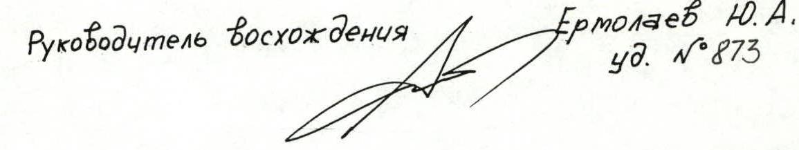
Mt. Geograf (3400 m)
Route 3A cat. diff. (rocky) via the S. slope and W. ridge.
| № | Length (m) | Steepness (°) | Cat. diff. |
|---|---|---|---|
| R8 | 30 | 35 | 2 |
| R7 | 30 | 55 | 3 |
| R6 | 50 | 70 | 3 |
| R5 | 50 | 45 | 2 |
| R4 | 60 | 45 | 2 |
| R3 | 60 | 50 | 3 |
| R2 | 50 | 65 | 3 |
| R1 | 80 | 75 | 3 |
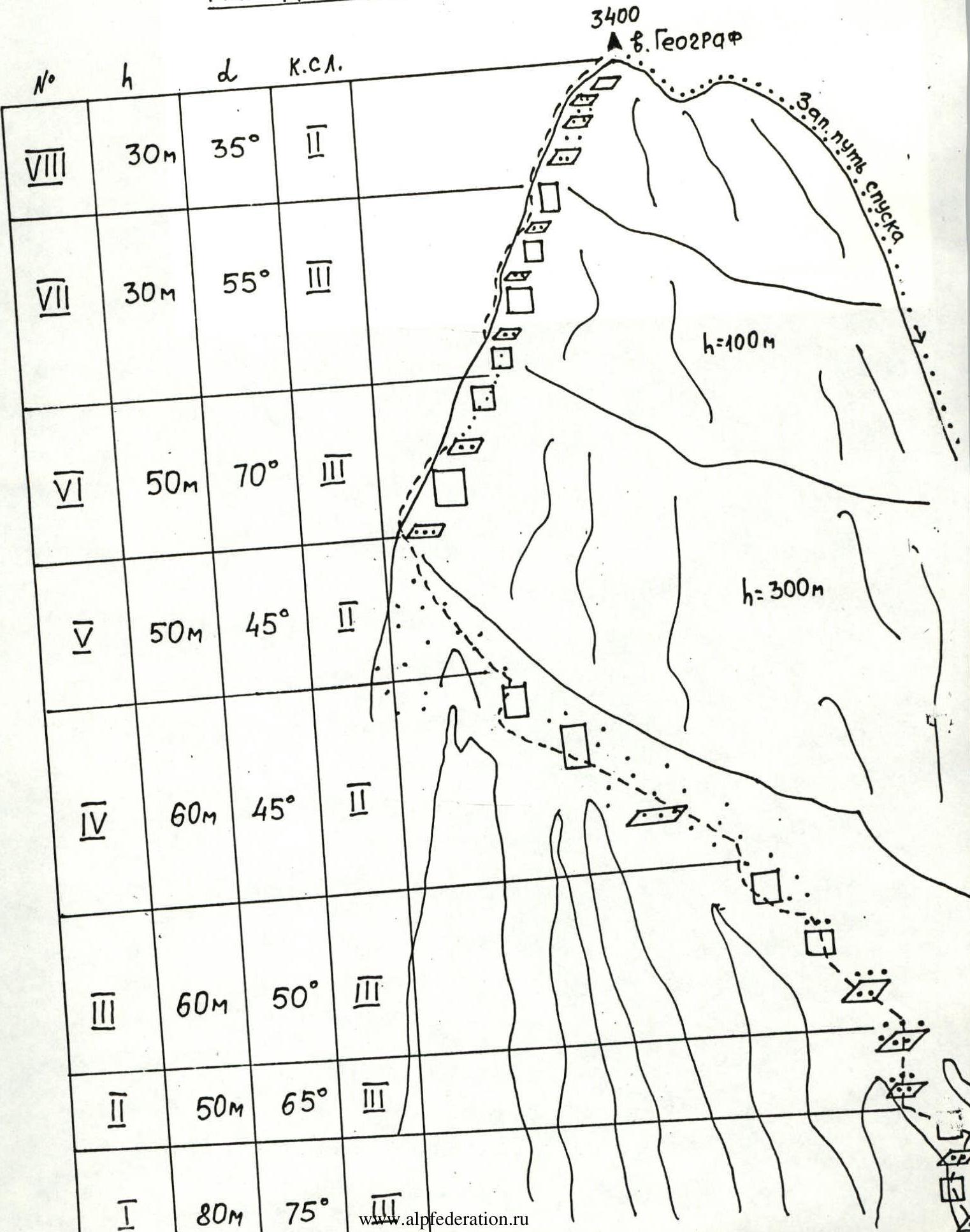
Mt. A. Vereteno
 Mt. Geograf, 3420 m
View from the route to Mt. A. Vereteno on Mt. Geograf