168
PASSPORT
- Class — first ascent.
- Altai, Severo-Chuysky Ridge, Karakabak gorge.
- V. Achkasova via the north ridge.
- Proposed 3B cat. dif. (first ascent).
- Height 3696 m, height difference 680 m, length 1230 m, average slope 33°.
- Pitons — 6 cams, 8 ice screws.
- Climbing hours 18 (from camp to camp).
- Recommended to camp on the glacier at the start of the route.
- In a team of two
| Vinnikov K. E. | 1st sports category |
|---|---|
| Markin N. L. | 1st sports category |
| Drakin A. V. | 1st category, #68 |
- Date of ascent August 25, 1999.
- Organization Altai Regional Alpine Federation.
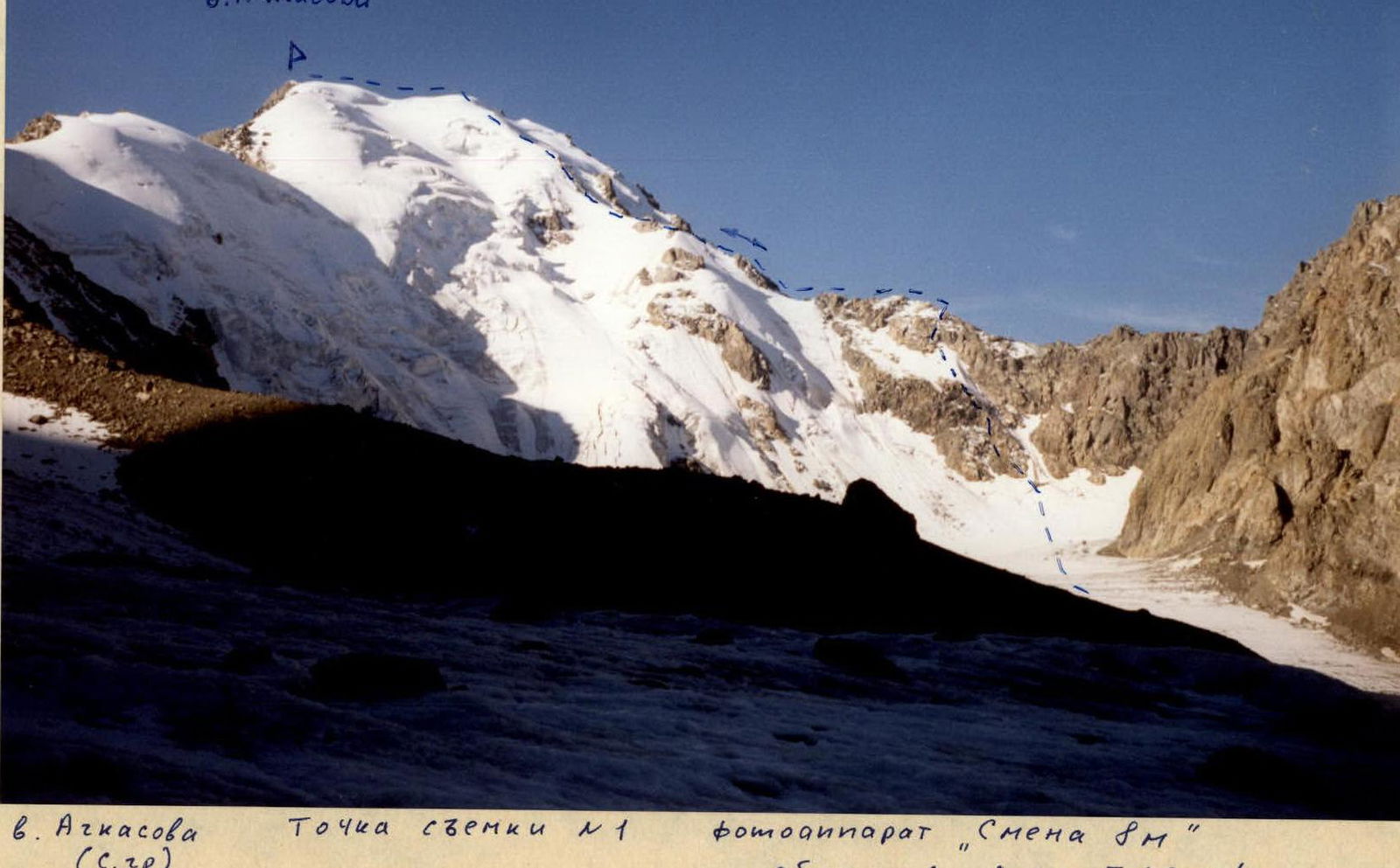
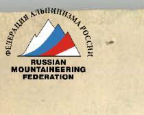
V. Achkasova via the north ridge
Brief description of the area
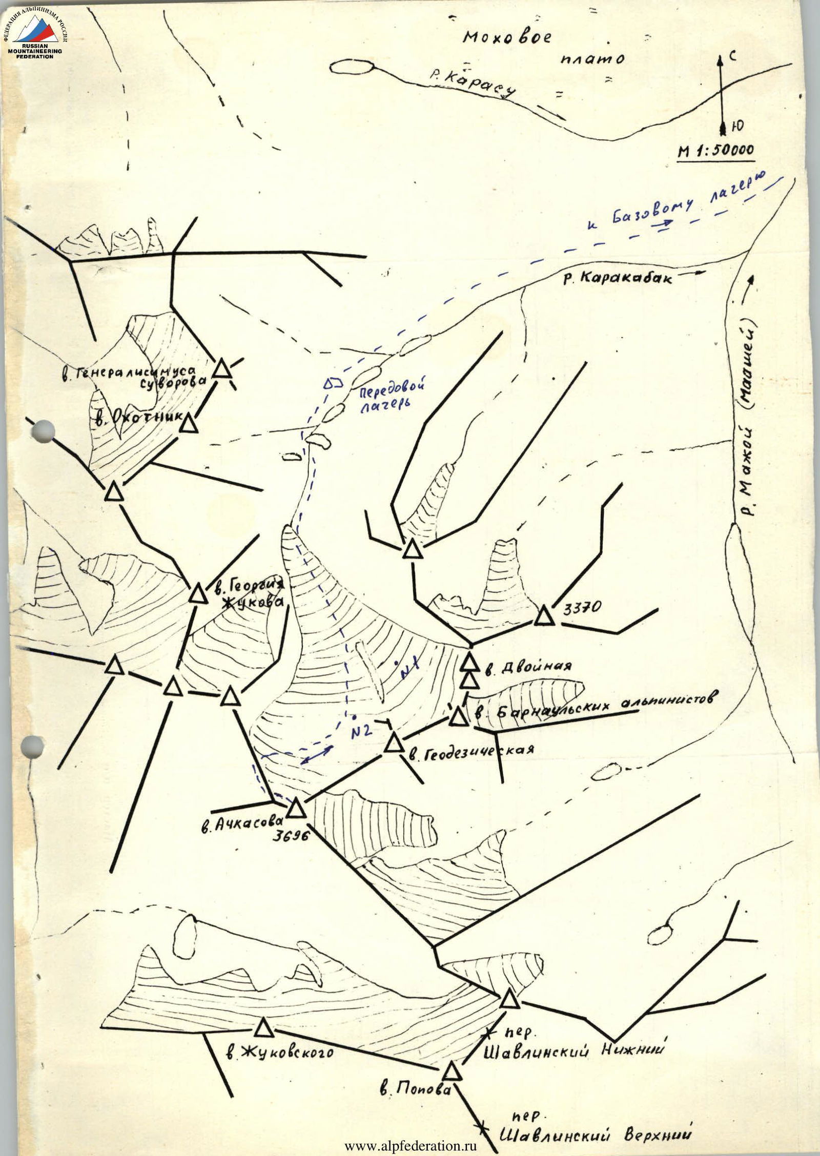
The Karakabak River is an orographic left tributary of the Mazhoy (Maashey) River. Different maps may show different names for this river. Mazhoy and Mashey can be found on topographic maps. Moreover, the name Mazhoy is more common. The name Maashey is mostly found on tourist schematic maps.
Access to the area is via the Chuya Highway to the settlement of Chibit. In Chibit, turn off the Chuya Highway and drive along the Chuya River for 15 km to the confluence of the Mazhoy (Maashey) River. There is a road bridge across the Chuya River at this point. Cross the Chuya River, overcome a steep climb with hairpin bends, and drive along the Mazhoy (Maashey) River valley to the upper zimovye (winter settlement). There is no road beyond this point. The section from Chibit to the upper zimovye can only be traversed by a high-clearance vehicle. From the zimovye, you can reach the upper reaches of the Karakabak River either by following the Karakabak River, ascending a forested slope, or by following a small ridge separating the Karakabak River valley from a swampy plateau. Above the forest zone, there are a series of lakes along the river. The hike to the lower lake takes 2-3 hours from the upper zimovye.
An expedition of climbers from Barnaul set up a base camp near the upper zimovye and an advanced camp above the second lake. All ascents were made from the advanced camp.
The area is rarely visited by climbers. Although climbers have ascended most of the high and prominent peaks. Cairns with notes have been built. Climbers from the Lokomotiv Sports Society from Novosibirsk and Barnaul made ascents in 1976 and 1982. Apparently, no reports were submitted to the classification committee. Although a report was submitted for the route to the summit of V. Achkasova.
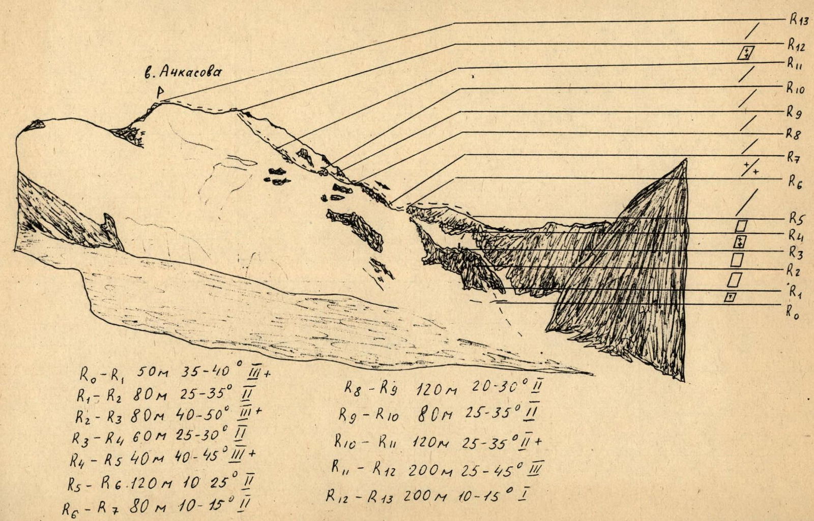
V. Achkasova via the north ridge
From the advanced camp, located above the second lake on the Karakabak River, move along the left (orographic) bank, bypassing the third and fourth lakes, to a moraine rampart blocking the river valley. Ascend the moraine rampart and continue along the river to the glacier tongue. Follow the glacier to the slope that leads to a saddle in the north ridge of V. Achkasova peak. The approach from the camp takes 4-4.5 hours.
The ascent to the saddle begins to the left of the couloir, which leads to a snow-and-ice terrace below the rocks of the saddle. The bergschrund is traversed via a plug filled with stones. Then follows an ascent up an ice slope with a slope angle of 40° and a length of 50 m. Move with protection via ice screws.
Next is an 80-meter slope consisting of loose rocks. This section is technically not difficult, but is very prone to rockfall, and it is hard to set up protection.
The next 80 m — monolithic rocks, with a slope angle of 50-55°. Move in turns, with piton protection.
Next is a snow-and-ice terrace. Slope angle 30-35°, length 60 m.
The terrace leads to a rock wall with a length of 40 m and a slope angle of 40-45°. Traverse it with protection via a ledge or with pitons.
In the direction of the summit follows the north ridge, where long sections of pure rock are interspersed with ice. The overall slope angle of the ridge is 20-25°, with both rock and ice rated as 2nd category difficulty. The final rock section leads to an ice slope on the north ridge with a length of 200-220 m and a slope angle of 30-35°. Two steep sections have a slope angle of up to 45°. Move in turns, with piton protection.
The summit is a ridge with a length of 200-250 m, having two highest points of roughly equal height to the east and west. The cairn is built on the eastern elevation.
Descent is via the ascent route.
R0–R1 50 m 35–40° 3+ R1–R2 80 m 25–35° 2 R2–R3 80 m 40–50° 3+ R3–R4 60 m 25–30° 2 R4–R5 40 m 40–45° 3+ R5–R6 120 m 10–25° 2 R6–R7 80 m 10–15° 2 R8–R9 120 m 20–30° 2 R9–R10 80 m 25–35° 2 R10–R11 120 m 25–35° 2+ R11–R12 200 m 25–45° 3 R12–R13 200 m 10–15° 1


