I. Climbing category: snow and ice 2. Climbing area: Altai, Katunsky ridge, Koni-Airy gorge 3. Peak: G.I. Choros-Gurkina (3350 m), via the north-eastern ridge 4. Proposed category: 1B, first ascent 5. Elevation gain from the col: 550 m 6. Average slope: 25–35° 7. Total length: 700 m 8. Pitons driven: 9. Climbing time: 8–9 hours. Days — 1
- Climbing participants:
- Gerasimov V.B. — 1st sports category
- Shumilov V.D. —
- Mikhalev S.V. —
- Kindikov Z.V. —
- Kelyuev V.N. — 2nd sports category
- Pomazkin G.N. — 1st sports category
- Ivanov A.I. — badge holder
- Surazakov A.B. — badge holder
- Zavchuk D.V. — badge holder
II. Coach and climbing leader: Zavchuk V.A. — instructor, 2nd category
12. Departure to the route: September 2, 1995, summit: September 2, 1995, return to camp: September 2, 1995
13. Organization: Altai Republican Federation of Alpinism and Rock Climbing (ARFARC)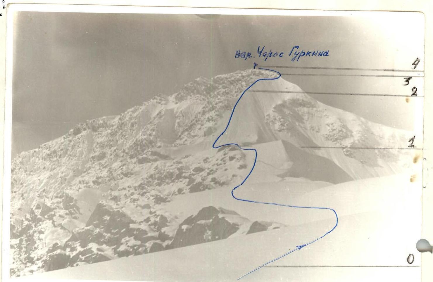 www.alpfederation.ru↗
Brief overview of the area, approach to the route description
The peak is located on a section of the Katunsky ridge where its snowy and icy slopes give rise to the Koni-Airy Central and Koni-Airy Western glaciers.
The south-eastern ridge of the peak G.I. Choros-Gurkina connects to a nameless peak, from which the main ridge of the Katunsky ridge turns east, connecting to the three-peaked Koni-Airy massif, which with its northern edge encloses the cirque of the Koni-Airy Central glacier.
The snowy and icy slopes of the north-western and north-eastern ridges of the peak G.I. Choros-Gurkina feed the Koni-Airy Western glacier with a glacier fall at its foot, divided by a rocky outcrop. The adjacent north-western ridge of the peak G.I. Choros-Gurkina to the Maadai-Kara massif is the Koni-Airy col (3125 m). The north-eastern ridge, which separates the two cirques (glaciers Koni-Airy Central and Koni-Airy Western), connects to a low peak — Kuchuk-Tash.
The initial bivouac can be conveniently set up at the forest boundary, below the confluence of the two sources of the Koni-Airy river. From the initial bivouac, cross the Koni-Airy river, then, having ascended the ancient moraine ramparts, approach the dried-up basin of a small lake, slightly above which the Koni-Airy Central glacier begins (1 hour's walk). Keeping to the right edge of the glacier (in the direction of travel), move until you reach the crevasses (which are bypassed on the right — you need to ascend the talus slope of Kuchuk-Tash, traverse it, and rejoin the glacier). Moving along the glacier along the rocks of Kuchuk-Tash, at its terminal massif turn right, where a snowy ascent (70–90 m) opens up. Ascend this to the col of Kuchuk-Tash and the north-eastern ridge of the peak G.I. Choros-Gurkina.


Tactical actions and route description
R0. The route begins from this point (col). The route is a ridge climb, snow and ice, and is not particularly difficult. Movement is simultaneous, in rope teams, as there are ice crevasses. Belaying is done with ice axes. Length 300 m, 10–15°. R1–R2. Snowy 35° ascent, 160 m. Belaying with ice axes. Simultaneous movement. R2–R3. Rocky ridge, covered in snow. The rocks are fragile, and are bypassed on the right in the direction of travel. Belaying is done using rocky outcrops or through an ice axe. Exit to the pre-summit ridge. Length of section 140 m, ridge slope — 35°. R3–R4. Short pre-summit ridge 40–50 m. Gentle. Exit to the summit, where a trig point stands. Descent from the summit is done via the ascent route.
General view
of peak G.I. Choros-Gurkina for the first ascent report by the ARFARC sports training group from Gorno-Altaisk.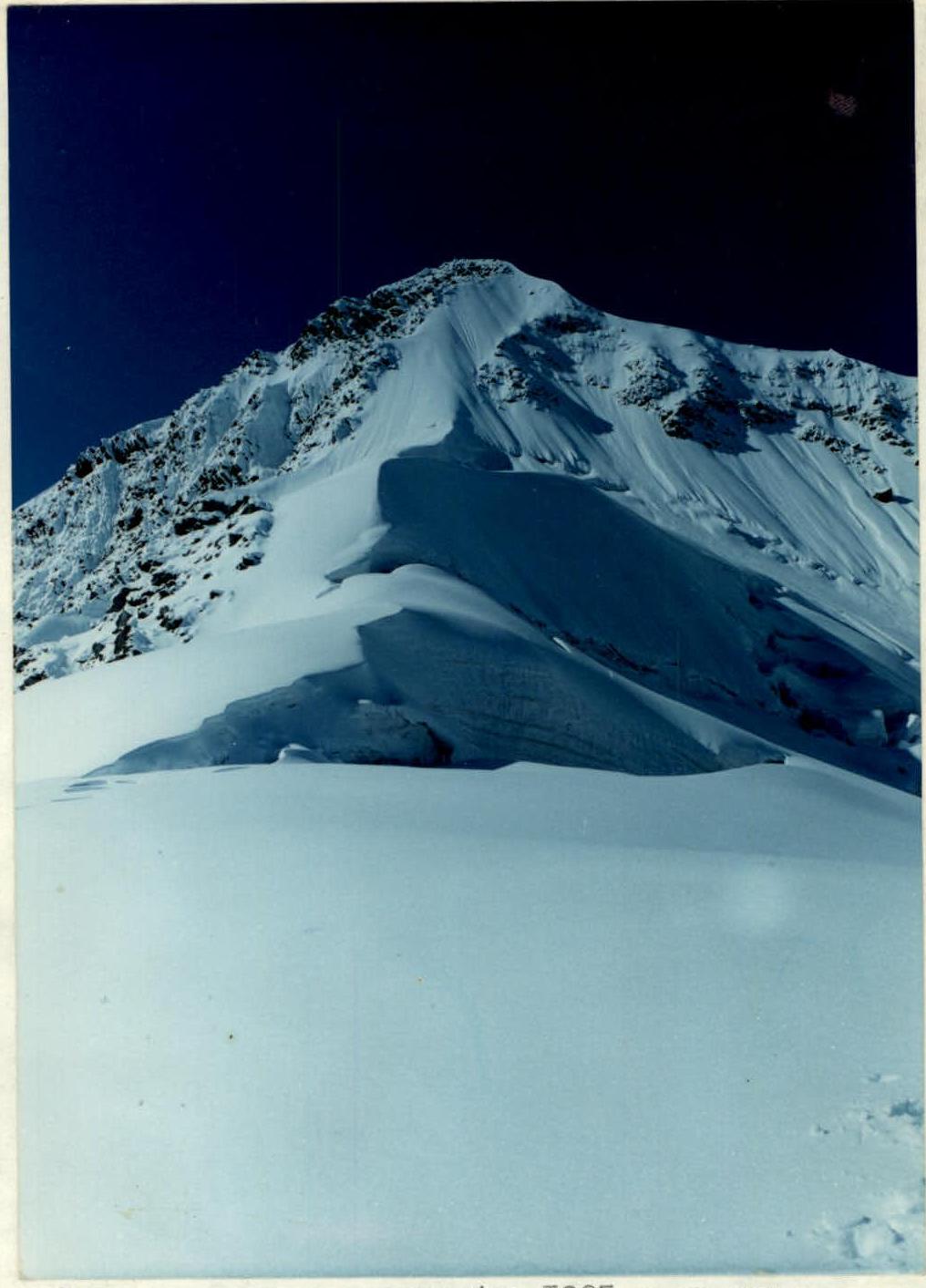
The photo was taken in September 1995 on the day of the ascent from the col.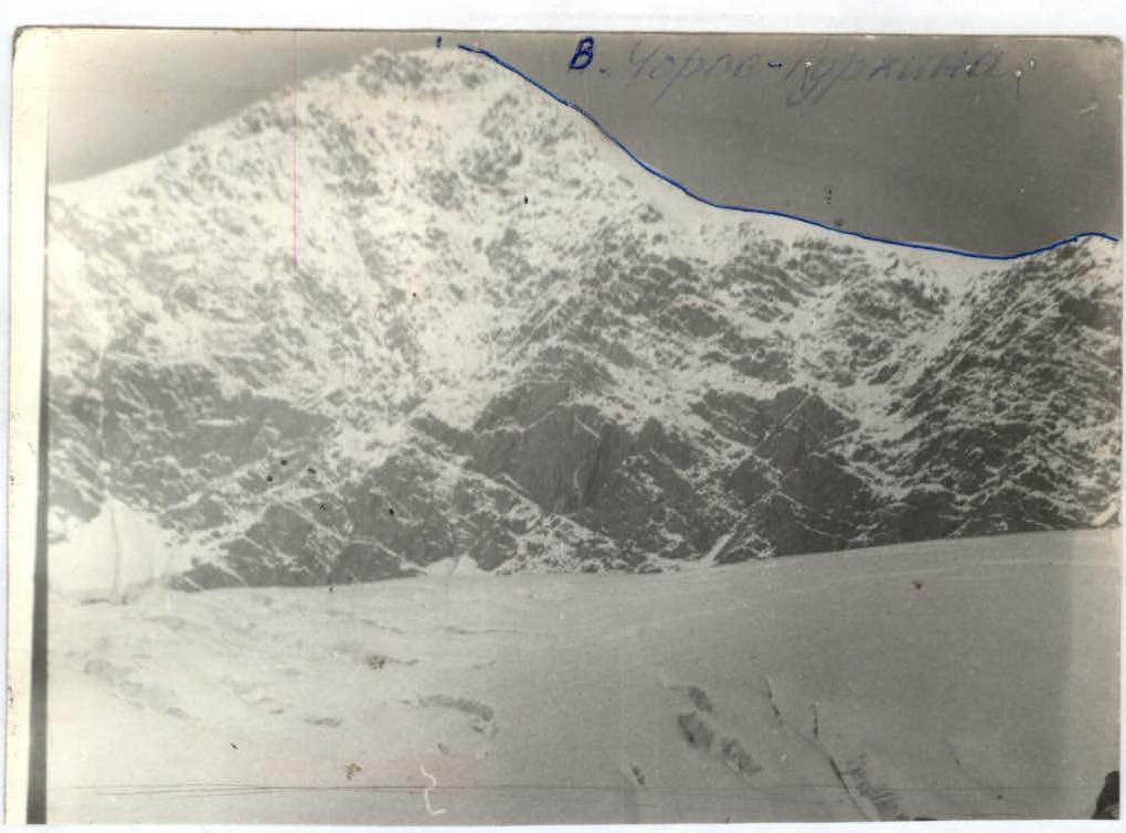
Route profile on the right
The photo was taken in September 1995 with a ZENIT camera.