ASCENT DOCUMENT
-
Ascent class — technical.
-
Ascent area, ridge: Altai, Katunskie Belki ridge.
-
Peak, its height, ascent route, route type: p. Delone 4260 m, NW buttress, combined.
-
Proposed category of difficulty: 5A cat. diff.
-
Route characteristics: height difference — 1260 m, length of 5th category difficulty sections — 575 m, average steepness — 55°.
-
Pitons hammered: rock and chockstones — 35, ice screws — 56.
-
Number of climbing hours: 16 hours.
-
Number of nights and their characteristics: one on the descent.
-
Full name of the leader, participants, their qualification:
Neiman D.Z. — 1st sports category, leader Yakovenko A.N. — CMS, participant Slastnikov G.Ya. — 1st sports category, participant Grebenyuk D.N. — 2nd sports category, participant
-
Team coach: Afanasiev A.E. — ICMS
-
Date of departure and return: July 9, 1986.
-
Organization: Classification competitions SKA-19.
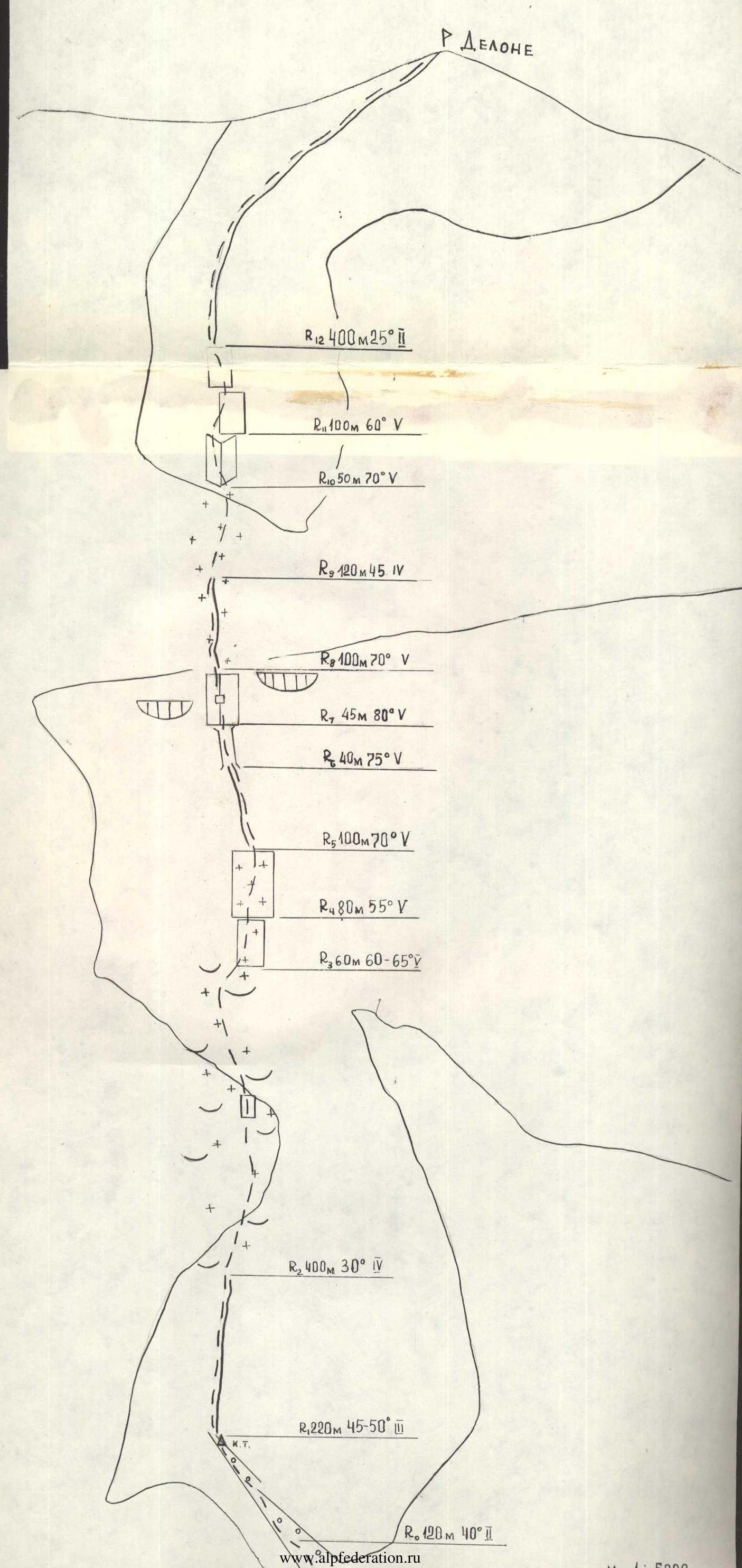
MAP of Ak-kem area

Approach to the route description
The ascent to p. Delone via the NW buttress is more conveniently started from the "Tomskie nochiovki" campsite. From the base camp on Ak-kem lake, it takes 6 hours to reach "Tomskie nochiovki". You need to move along the left side of the lake and river, crossing to the other bank between the Upper and Lower lakes. The exit to the Ak-kem glacier is along a trail marked with cairns. It's more convenient to ascend the glacier via the central part. The passage through the icefall to the upper cirque is along the right bank among the crevasses.
"Tomskie nochiovki" is located on a lateral moraine under the slopes of p. Podstennaya. There's a KSS tent with a stove here.
From "Tomskie nochiovki", crossing the upper cirque with a slight descent, you approach the foot of the central (northwestern) buttress of p. Delone. The route begins with a talus-filled couloir that leads to the ridge of the buttress on the right.
Brief explanations for the table
- R0–R1 — talus-filled couloir leading to the buttress, with a control cairn on the buttress.
- R1–R2 — rocky, destroyed crest of the buttress, with difficult climbing in some places.
- R2–R3 — ice patches, left of the ridge.
- R3–R4 — wall, difficult climbing, iced, monolithic.
- R4–R5 — ice slope, with frozen rock slabs in the middle part.
- R5–R6 — ridge, difficult climbing, monolithic slabs.
- R6–R7 — chimney filled with ice.
- R7–R8 — traverse to a slab with a vertical crack, "Zaltsug" overhangs on the right and left.
- R8–R9 — ridge.
- R9–R10 — ice patch with small rock outcrops.
- R10–R11 — upper bastion, internal corner.
- R11–R12 — system of rock slabs.
- R12–R13 — summit ridge.
Route diagram in symbols