11.69
Climbing Passport
-
Region — Altai, Katunsky ridge, Miushtairy gorge
-
Peak — Vector (3716 m), via the center of the NW wall
-
Proposed — 6B category of difficulty, first ascent
-
Route type — rock
-
Route characteristics: height difference — 1200 m route length — 1515 m length of 6 category of difficulty sections — 600 m 5 category of difficulty — 180 m average steepness — 64° height difference of the rock section — 800 m length of the rock section — 865 m average steepness of the main rock section — 81°
-
Left on the route: 37 pitons, including 31 bolt pitons. Pitons used on the route: a) for climbing and belaying:
- stationary bolt pitons — 15, including 15 ITDs
- removable bolt pitons — 12, including 12 ITDs b) for organizing stations:
- stationary bolt pitons - 16
- removable bolt pitons — 3 c) for hanging platforms:
- stationary bolt pitons — 10
- removable bolt pitons — 10
Total ITDs used (including fif usage) — 525.
-
Number of travel hours — 140, days — 17, including descent.
-
Team leader — Ivanov Vitaly Borisovich, Candidate Master of Sports. Team members:
- Avdienko Alexey Alexandrovich, Candidate Master of Sports
- Brits Maxim Vladimirovich, 1st sports category
- Slobodchikov Igor Vladimirovich, Candidate Master of Sports
-
Team coaches: Ivanov Vitaly Borisovich, Avdienko Alexey Alexandrovich
-
Departure date: to the route — March 7, 2006 at 8:00; to the summit — March 23, 2006 at 8:00; return to BL — March 23, 2006 at 23:00.
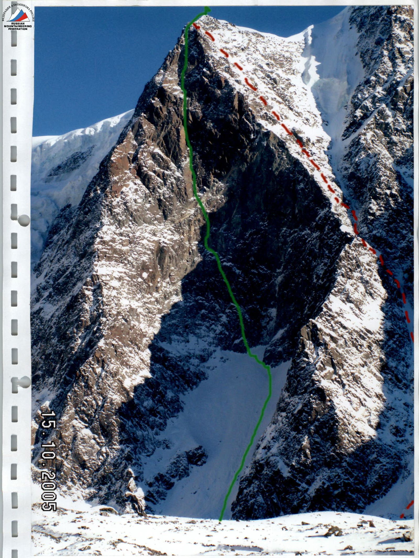
Photo # 1. Vector peak (3716 m)
- Ascent route
- Descent route
Taken during the reconnaissance on October 15, 2005 from Miusht-Airy glacier

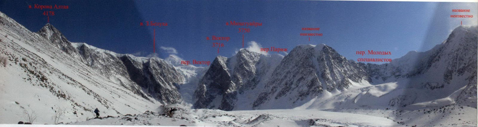
Photopanorama of the area

Peak 3716

Overview of the Climbing Area
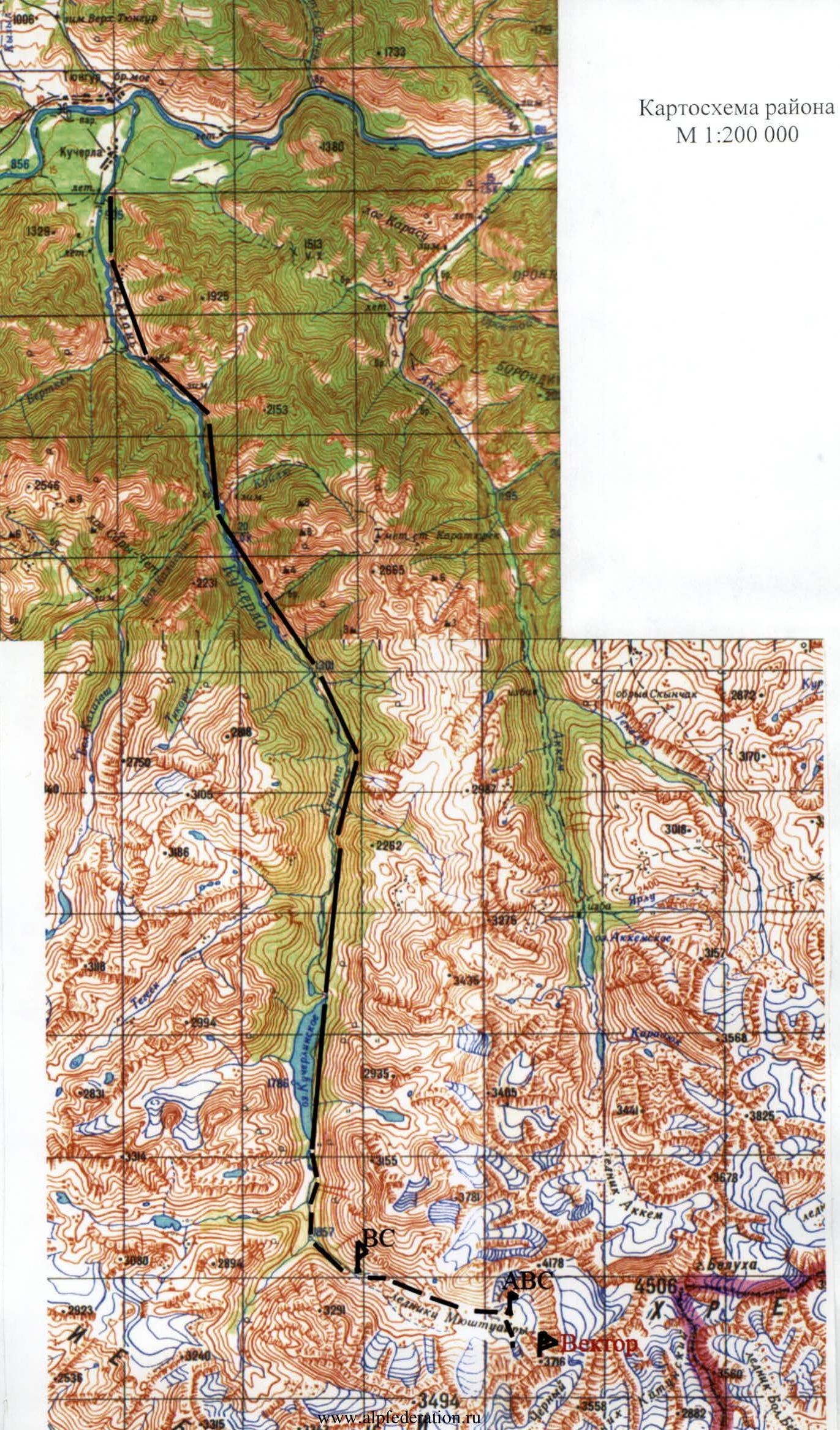
Peak Vector (3716 m) is located in Altai, in the Katunsky ridge, in the Miushtairy gorge, to the west of the highest point of Altai, Belukha mountain (4506 m). The approach to the mountain takes a long time. From the village of Tyungur (through this village lies virtually all the path to Belukha mountain from Russian territory) to Kucherlinskoye Lake is 50 kilometers. This distance is covered:
- in two days on foot or by horse (in summer);
- in winter, horses deliver cargo to the beginning of the lake over the ice.
In summer, the path along the lake takes 2–3 hours on foot along the trail or 20 minutes by boat. In summer, horses cannot pass along the lake. Further, along the right bank of the river, the ascent to the moraine ridge of the Miushtairy glacier takes:
- 4–5 hours in summer;
- 3–4 hours in winter, if there is little snow and it is possible to walk on the ice of the river.
At the end of the moraine ridge, at the site of a burned-down hut, a base camp was set up. Transporting cargo from Kucherlinskoye Lake to the base camp took our team 3 days. From the base camp to the wall of Vector peak is another 3–4 hours of walking along the right moraine ridge of the glacier.
Glacier features:
- the ice is covered with a powerful moraine cover;
- open ice is found only on the last two kilometers of the glacier;
- the maximum height of the glacier is 2600 m.
Two kilometers from the wall, on the right bank of the glacier, on the moraine, an advanced base camp was set up.
The Miushtairy glacier is bounded by the ice Western plateau of Belukha, which falls with a kilometer wall. Grandiose collapses occur constantly — several times during the day, as observed by the team members.
The area is well known and visited by tourists. There are several classified passes in the area (not lower than 2B), but there is not a single classified mountaineering route in the gorge. Although there are many potential routes for first ascents and climbs of any category of difficulty, such as:
- the southern wall of the peak XX years of October (Korona Altaya)
- the NW wall of v. Vector.
The low attendance of the area by climbers is associated with the duration of the delivery to the gorge. Our delivery took 7 days. The existence of a grandiose wall in the Miushtairy gorge has been known for a long time. There were even attempts to climb it (Irkutsk team led by Afanasiev A. in winter 2004), but they were unsuccessful.
The mountain is rockfall-prone. The wall is composed of sedimentary rocks and metamorphosed limestones and is an alternation of monolithic slabs with overhanging, heavily destroyed sections. The first 500 m are vertical slabs, then throughout the wall — a huge corniche with an overhang of up to 50 m and a 250 m "roof", also almost vertical. The descent from the mountain is not easy. We chose a descent along the Western slope and further along a giant couloir between Vector peak and Miushtairy peak. This is approximately 25 rappels. The descent route is not lower than 5A category of difficulty.
Map of the area
Scale 1:200 000
Ascent Schedule
| Section # | Pitons | Chocks, Friends | Bolt Pitons | Skyhooks | UIAA Symbol Scheme | Length, M. | Steepness, deg. | Category of Difficulty |
|---|---|---|---|---|---|---|---|---|
| 18 | 12/12 | 35 | 60 | IV | ||||
| ∅ | 15 | 90 | VI | |||||
| 17 | 10/10 | 12/11 | 1 | 50 | 80 | V | ||
| 16 | 15/15 | 10/10 | 2/1 | 50 | 80 | VI | ||
| 15 | 18/18 | 2/2 | 1 | 4/4 | Photo №12 | 50 | 70 | VI |
| 15 | 60 | VI | ||||||
| 20 | 80 | VI | ||||||
| 14 | 8/2 | 3/2 | 11/11 | 15 | 85 | V | ||
| 20 | 130 | VI | ||||||
| 18, 19 March | ||||||||
| 13 | 12/12 | 6/5 | 20/20 | Photo №11 | 30 | 90 | VI | |
| 12 | 12/12 | 5/4 | 1 | 40 | 80 | VI | ||
| 11 | 15/15 | 4/4 | 1 | 8/8 | Photo №10ab | 50 | 80 | VI |
| 10 | 12/11 | 6/6 | 3/2 | 3/3 | 50 | 80 | VI | |
| 9 | 5/5 | 4 | 3/2 | 8/8 | Photo №9ab | 20 | 70 | V |
| 15 | 110 | VI | ||||||
| 15 | 80 | V | ||||||
| 15 | 90 | VI | ||||||
| 8 | 10/10 | 5/3 | 10/10 | Photo №8 | 35 | 95 | VI | |
| 20 | 95 | VI | ||||||
| 10 | 90 | VI | ||||||
| 7 | 8/8 | 3/2 | 5/5 | Photo №7 | 10 | 90 | V | |
| 30 | IV | |||||||
| 6 | 6/6 | 4/2 | 1 | 20 | 70 | V | ||
| 25 | 90 | VI | ||||||
| 5 | 90 | VI | ||||||
| 5 | 5/5 | 8/7 | 3/2 | 9/9 | Photo №5, 6 | 20 | 80 | VI |
| 30 | 80 | VI | ||||||
| 4 | 5/5 | 2/2 | 5/3 | 10/10 | Photo №4 | 20 | 95 | VI |
| 20 | 95 | VI | ||||||
| 3 | 8/8 | 6/4 | 3/2 | 20 | IV | |||
| 10 | 70 | VI | ||||||
| 2 | 15/15 | 3/2 | 40 | 80 | VI | |||
| 10 | 70 | VI | ||||||
| 1 | 5/5 | 5/4 | 2/1 |
Route Description by Sections
| Section | Description |
|---|---|
| R0–R1 | Snow slope, in the center — rocky-osypnoy with sections of ice. On the sides, snow, under the snow — ice. Movement along the right part of the slope in crampons, belay through an ice axe. The slope is rockfall-prone!!! Under the cliff, under the protection of a small overhang, the first night's stay is organized. |
| R1–R2 | Beginning of the wall. Inner corner with deaf cracks. Leads to a small ledge, covered with snow (can stand with both feet). In the middle of the section, a piton is driven in for belaying. Station on a bolt piton. |
| R2–R3 | Continuation of the inner corner. After 10 m, it turns into a slab (40 m) with a corniche at the end (overhang about 1 m). The steepness increases. The section is climbed using anchor pitons. Station is hanging on a bolt piton. |
| R3–R4 | System of walls and inner corners, leading to a large sloping and inclined snow ledge, about 1 m wide and 15 m long. At the beginning of the ledge, the second night's stay is organized. The section before the ledge is extremely destroyed. When passing, maximum concentration and attention are required. Belay through pitons, chocks, and friends. |
| R4–R5 | The beginning of the section is an overhanging crack, 3–4 cm wide, with a corniche at the end. Fif of medium size go well. The crack goes along "live" stones. The edge of the section is a smooth slab with rare and "deaf" cracks. Passage on skyhooks through holes and using anchor pitons. Two bolts are driven into the slab (Ø8 and eighth removable). A semi-hanging station is organized on an inclined shelf. |
| R5–R6 | Continuation of the slab, another 25 m. Further, entry into a vertical inner corner with good cracks for friends and chocks. The corner is heavily destroyed. Passed mainly by free climbing. |
| R6–R7 | System of walls, slabs, and inner corners, leading to a huge ledge, 1.5 m wide. The ledge is sloping, but if desired, you can organize a night's stay and put up a tent, which is not worth doing, as the ledge is hit by rocks. |
| R7–R8 | From the ledge, along the inner corner (strongly destroyed), exit to a small ledge, closed by overhangs. Here the third night's stay is organized. Further, to the left, along a vertical slab (10 m), exit to an overhanging inner corner with a good crack for anchor pitons. The slab is passed on skyhooks. In the corner, a hanging station on a bolt piton. |
| R8–R9 | System of corniches with an overhang of up to 2 m. Passage using anchor pitons, skyhooks on relief, and channel pitons. Three bolts are driven into the section (spit, Ø10, Ø8). The system of corniches leads to an extremely destroyed inner corner, inclined to the left. |
| R9–R10 | Wall, passed by free climbing, belay — chocks and pitons. The wall leads to a marble niche. Here the fourth night's stay is organized. Further, straight ahead, through an overhang (15 m) on skyhooks through holes. Extremely difficult climbing. At the exit from the overhang, a Ø8 bolt is driven in. After the overhang — an inner corner, with snow and ice, leading to the "Huge Inner Corner". |
| R10–R11 | Monolithic inner corner with deaf cracks. The direction of movement is towards a huge corniche-overhang. Passage using anchors, skyhooks, and pitons. |
| R11–R12 | Continuation of the inner corner. There are fewer cracks. Large sections are passed on skyhooks on relief. |
| R12–R13 | Inner corner. Becomes more destroyed. Climbing is mainly on fif and requires maximum concentration. |
| R13–R14 | Transition to a vertical slab (30 m), which rests against a corniche-overhang. On the slab, the fifth night's stay is organized. On the slab, on skyhooks through holes and anchor pitons — approach under the corniche. The corniche is passed in the left, shortest (about 20 m) part, between blocks. For passage, fif of medium and large sizes were used. For belaying, three bolt pitons were driven in. They greatly helped in organizing the belay. |
| R14–R15 | Beginning of the "roof". The "roof" is rocks like "ram's foreheads", with steepness from 60 to 90°. The section is passed by free climbing along the inner corner (15 m). Further on skyhooks along the system of slabs. Belay through anchor pitons and bolts (removable). At the end of the section — the sixth night's stay. |
| R15–R16 | To the left — along an inclined inner corner with a deaf crack and monolithic, overhanging sections. Passed using fif and anchor pitons. At the end — a hanging station on a bolt piton. |
| R16–R17 | Straight up along a slab with a deaf crack. Passed on fif. Belay — pitons, friends, chocks. Station on a bolt piton. |
| R17–R18 | System of walls and inner corners. Alternation of free climbing and ITD. |
| R18–R19 | Along a strongly dissected vertical wall (15 m), exit to a snow-ice slope with embedded stones and along it to the ridge. A good place for a night's stay (seventh night's stay). |
| R19–R20 | Not difficult ridge (2–3) 100 m long. The summit is a snow cap. A tour is built below, to the right of the route. Control tours are left on each night's stay. These are plastic bottles (0.5 l), hanging on bolts. |
Tactical Actions of the Team
The NW wall of Vector peak is extremely rockfall-prone. Rocks fall always during the day and less often at night. Therefore, all tactical actions were subordinated to one goal — not to get under rockfall when passing the route. Therefore, the approach to the wall was carried out early in the morning and as quickly as possible. Almost all night's stays were located under the protection of corniches. Stations were also tried to be made under corniches and overhangs. The route thread was laid so that rocks falling from under the first did not hit other participants of the ascent. In the lower, most rockfall-prone part, the route goes from right to left.
The team had at its disposal:
- two two-seater platforms, which made it possible to organize night's stays in any place protected from falling rocks;
- six rope lengths, which allowed hanging the route from one protected place to another and choosing the most favorable and safe places for night's stays.
The mountain is composed of sedimentary rocks (shales) and metamorphosed limestones. This is an alternation of monolithic sections and extremely destroyed ones. Monolithic sections were passed using skyhooks on relief and through holes, belay was carried out using bolts and anchor pitons. Destroyed sections were passed using fif, belay on anchors, friends, and ordinary pitons. The main cracks on the route are deaf, up to 5 cm deep, with a width of 1 to 10 mm. Therefore, mainly pitons were used during the passage, especially box and channel pitons, and, of course, anchor pitons. There are cracks for friends and chocks, but not many.
For hanging platforms, organizing stations, and belaying during the passage, bolt pitons were used. The team had 6 types of bolt pitons at its disposal: a) for hanging platforms, spits and bolts (long life) Petzl Ø12 mm were used; b) for organizing stations, stationary bolt pitons Ø10 mm, 30 mm long, were used, as well as removable bolts Ø10 mm; c) for organizing belay during the passage, standard bolt pitons Ø8 mm were used, as well as their removable modification.
Climbing the wall is very rigid ITD on slabs and overhanging, destroyed rocks. Any non-monolithic relief is destroyed, vertical sections that require maximum concentration and attention when passing, as well as luck. Climbing monoliths was carried out on skyhooks through holes and relief from crack to crack. Cracks are usually deaf. Anchor pitons were a great help. Holes for skyhooks in hard rocks were drilled Ø6 mm, in soft rocks Ø8 mm. But not the entire route was passed on ITD. About 200 m of the wall were passed by free climbing.
The weather during the passage of the route was unstable. Snowfalls alternated with cloudy and clear days. The temperature during the day reached –10–15 °C, at night — about –20 °C. One day was extremely cold, the temperature dropped to –30 °C during the day. During snowfall, snow clogged the relief and rare cracks. It was necessary to clear the path before:
- finding a crack;
- putting a skyhook or fif.
Snow-clearing and rock-removal work, constant cold, maximum complexity of the relief slowed down the speed of movement along the route. It was possible to pass only 50–100 m of the wall per day.
To ensure additional safety, round-the-clock observation was organized by rescuers from the "Emergency Rescue Service of the Novosibirsk Region", with whom regular radio communication was maintained (at intervals of 2 hours from 8:00 to 22:00). In addition, a constantly turned-on radio station was located in the base camp, and a satellite phone was also available. In case of unforeseen circumstances, an insurance contract was concluded, according to the terms of which a helicopter was supposed to arrive (flight time — about 3 hours). The observers included a doctor with the necessary medications.
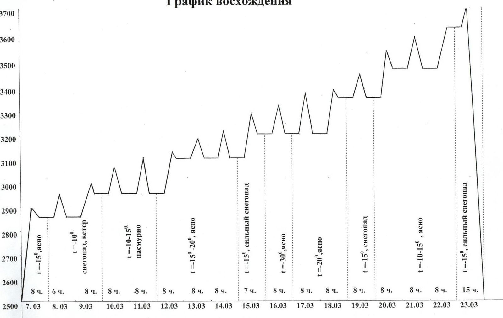
March 7
Approach to the wall along a snow-ice slope. Movement in crampons, belay with the help of ice axes. We reached the wall but passed only 40 m along the rock. Night's stay under the wall.
March 8
In the morning — heavy snowfall. We went to the wall only after 12:00 and climbed to the snow ledge. This is about 100 m. We did not transfer the camp due to snowfall and again spent the night under the wall.
March 9
Again, snowfall all day. We transferred the platforms to the snow ledge — section R4. We climbed another 20 m along the overhanging wall.
March 10
We passed another 80 m. Climbing on skyhooks along a monolithic slab. We spent the night on the ledge.
March 11
We passed 60 m and reached the second snow ledge, on which, if necessary, you can put up a tent, but the ledge is extremely rockfall-prone.
March 12
We transferred the camp a little higher than the second snow ledge and climbed about 40 m higher.
March 13
We passed 50 m along the system of corniches. One of the most difficult and dangerous ropes on the route.
March 14
We passed the first overhang R9–R10 and entered a giant inner corner.
March 15
Heavy snowfall. We transferred the platforms under a large overhang at the entrance to the inner corner. We passed 50 m along the inner corner.
March 16
Severe frost. Temperature around –30 °C. We passed another 50 m along the inner corner.
March 17
We passed 40 m during the day. We approached under a giant corniche, crossing the entire wall.
March 18
We transferred the camp under the corniche. We continued to drill on skyhooks and anchors on the slab (about 30 m).
March 19
We passed the corniche and reached the "roof". Further along the inner corners. This is about 50 m. The whole day snowfall.
March 20
We transferred the camp above the corniche. We passed along the system of slabs another 70 m.
March 21
Climbing along the "roof". Passed about 100 m.
March 22
Having passed two ropes, we reached the ridge, where we organized a night's stay on a good ledge.
March 23
We left at 7:00 and were on the summit at 8:00. We began the descent along the Western slope and reached the advanced base camp at 23:00 (met our observers). The descent is approximately 25 rappels along rocks, ice, snow, and firn, and another 200 m at the same time. We descended in heavy snowfall.
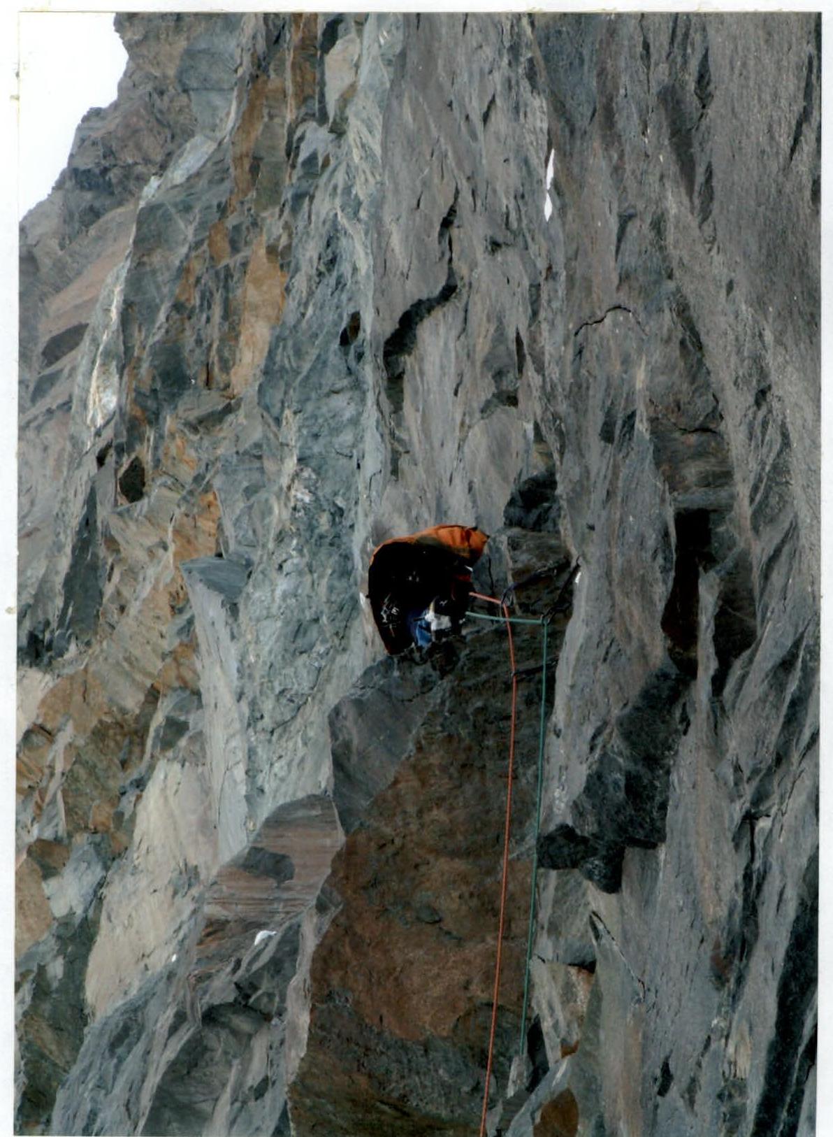
Photo # 4. Passage of section R4–R5. Passage of the crack with a corniche
2017
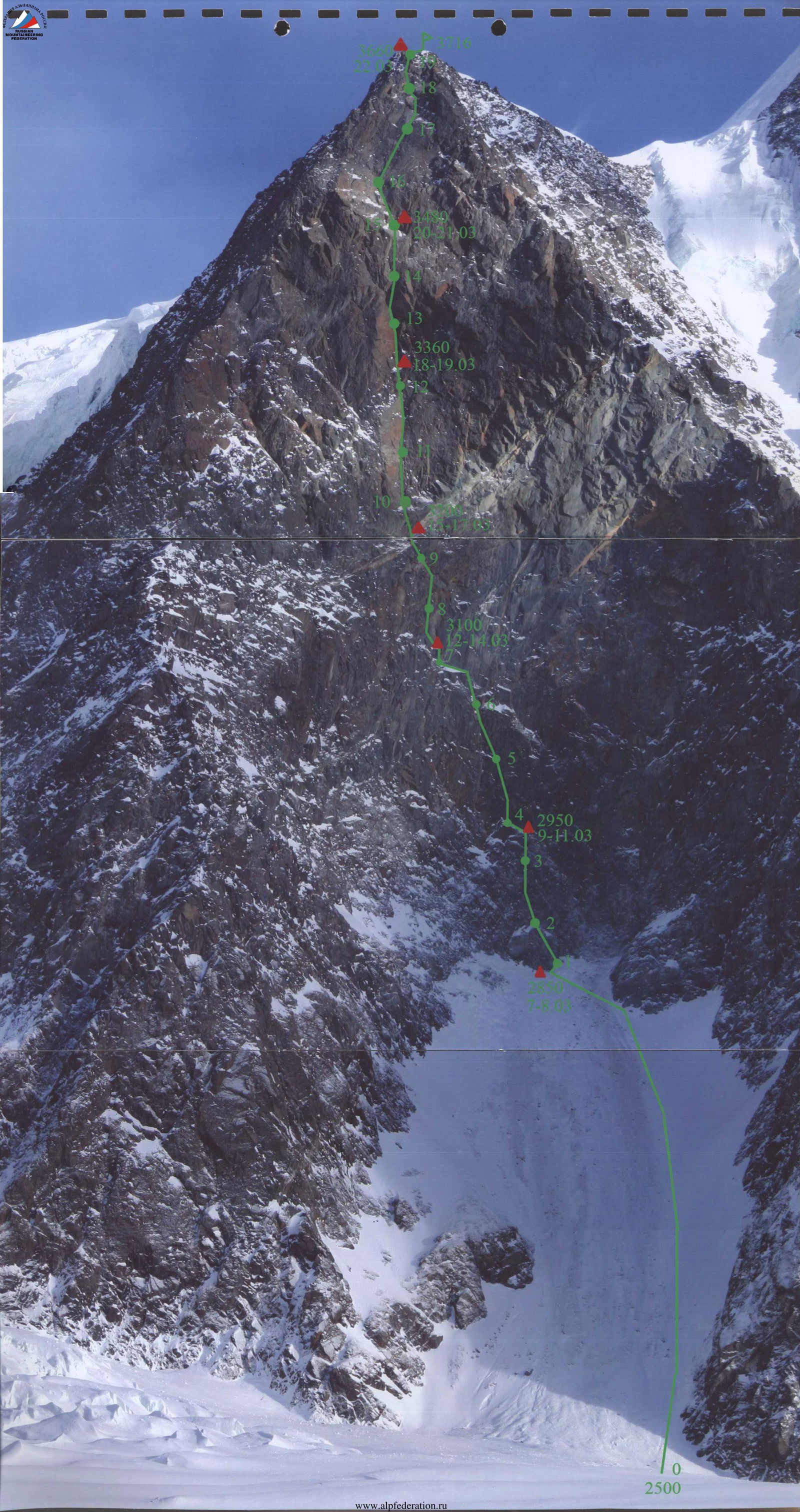
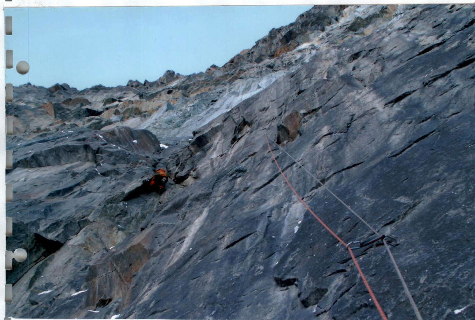
Photo # 6. Passage of section R5–R6. Passage of the inner corner
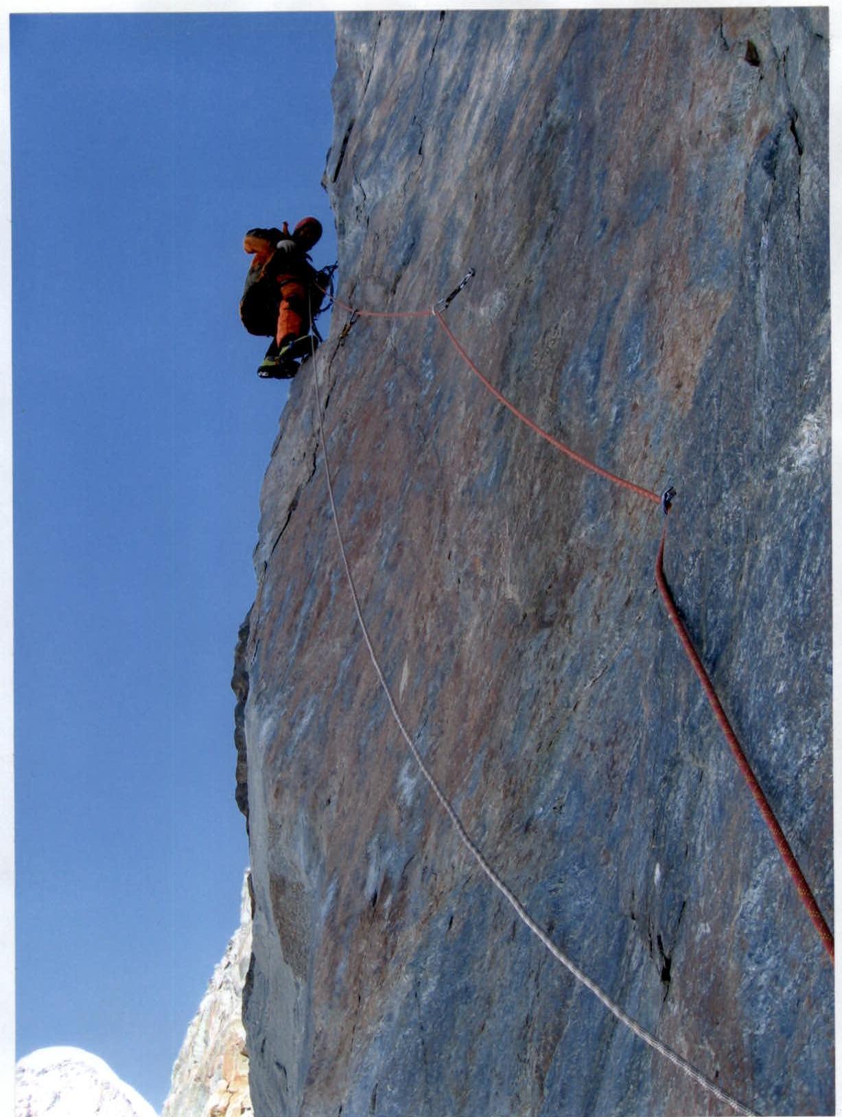
Photo # 7. Passage of section R7–R8. Passage of the slab
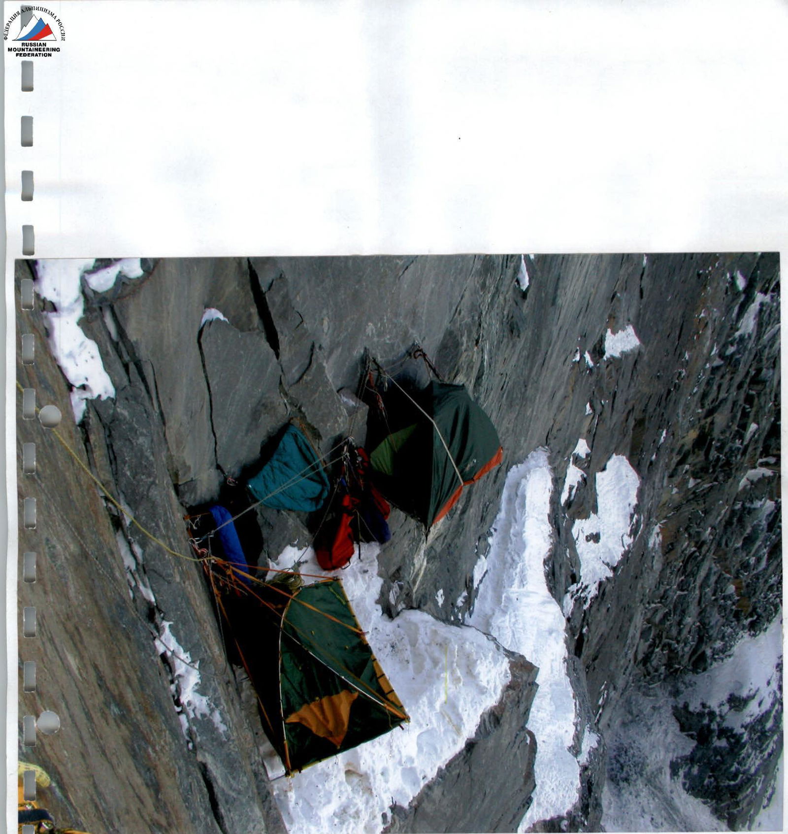
Photo # 7a. Night's stay # 3
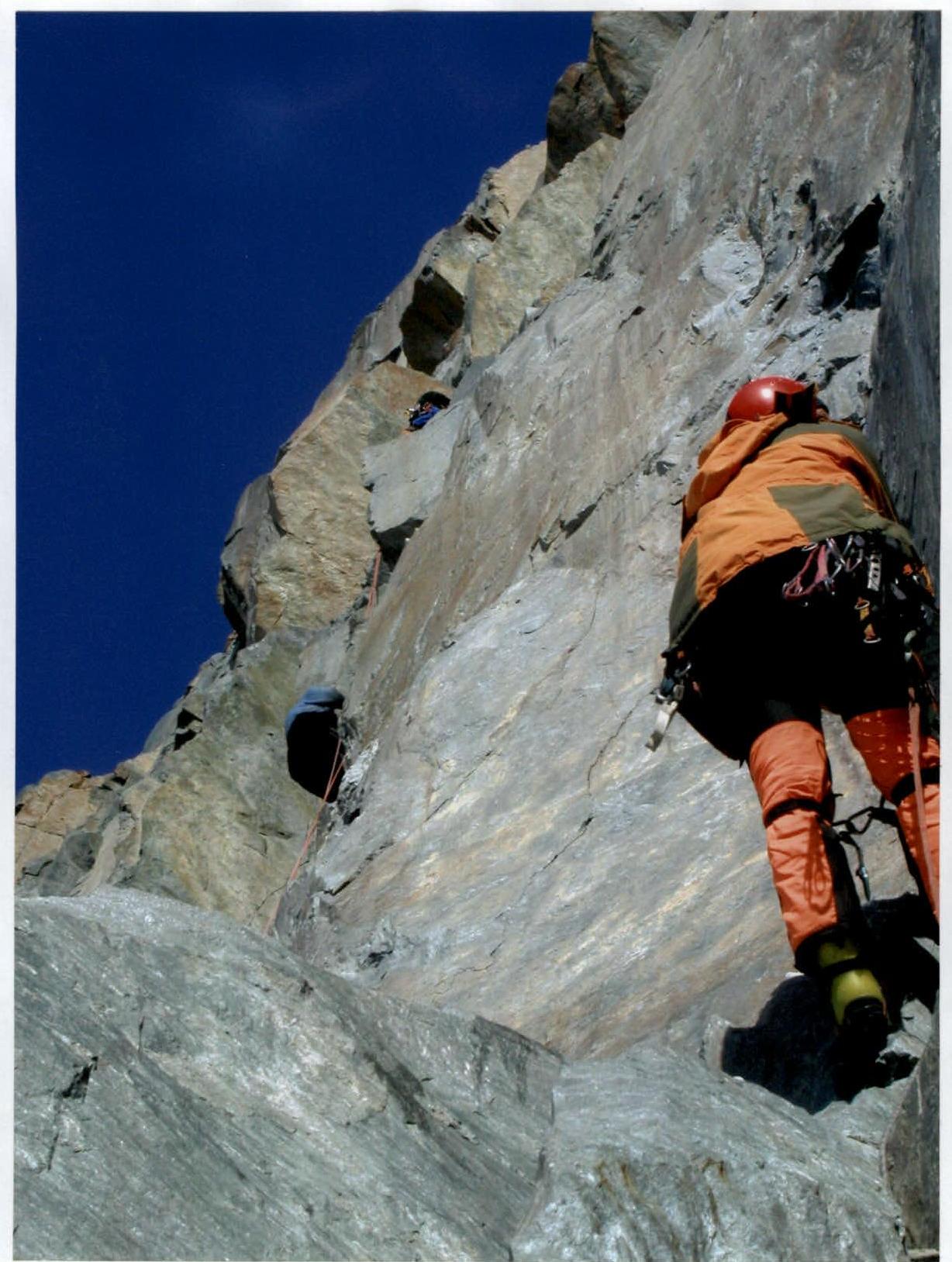
Photo # 8. Passage of section R8–R9. Passage of the belt of corniches
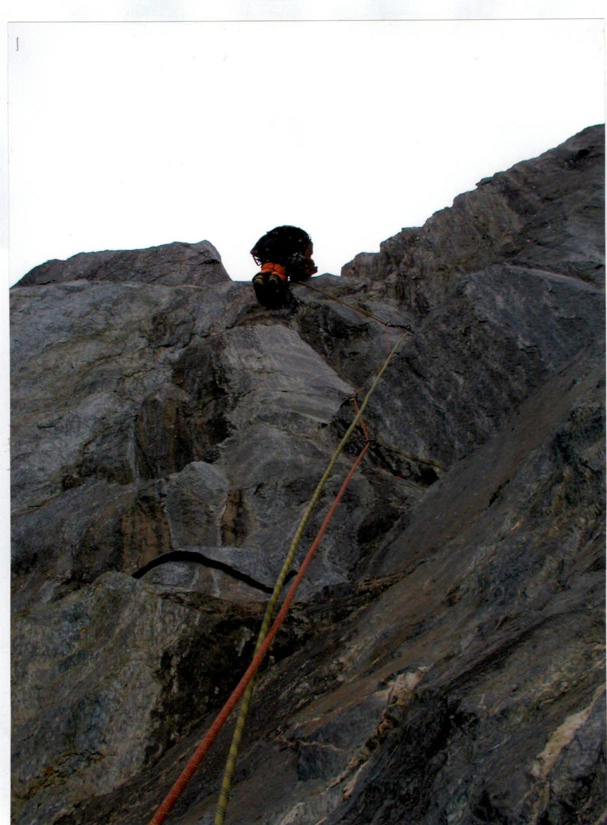
Photo # 9a. Passage of section R9–R10. Passage of the first overhang
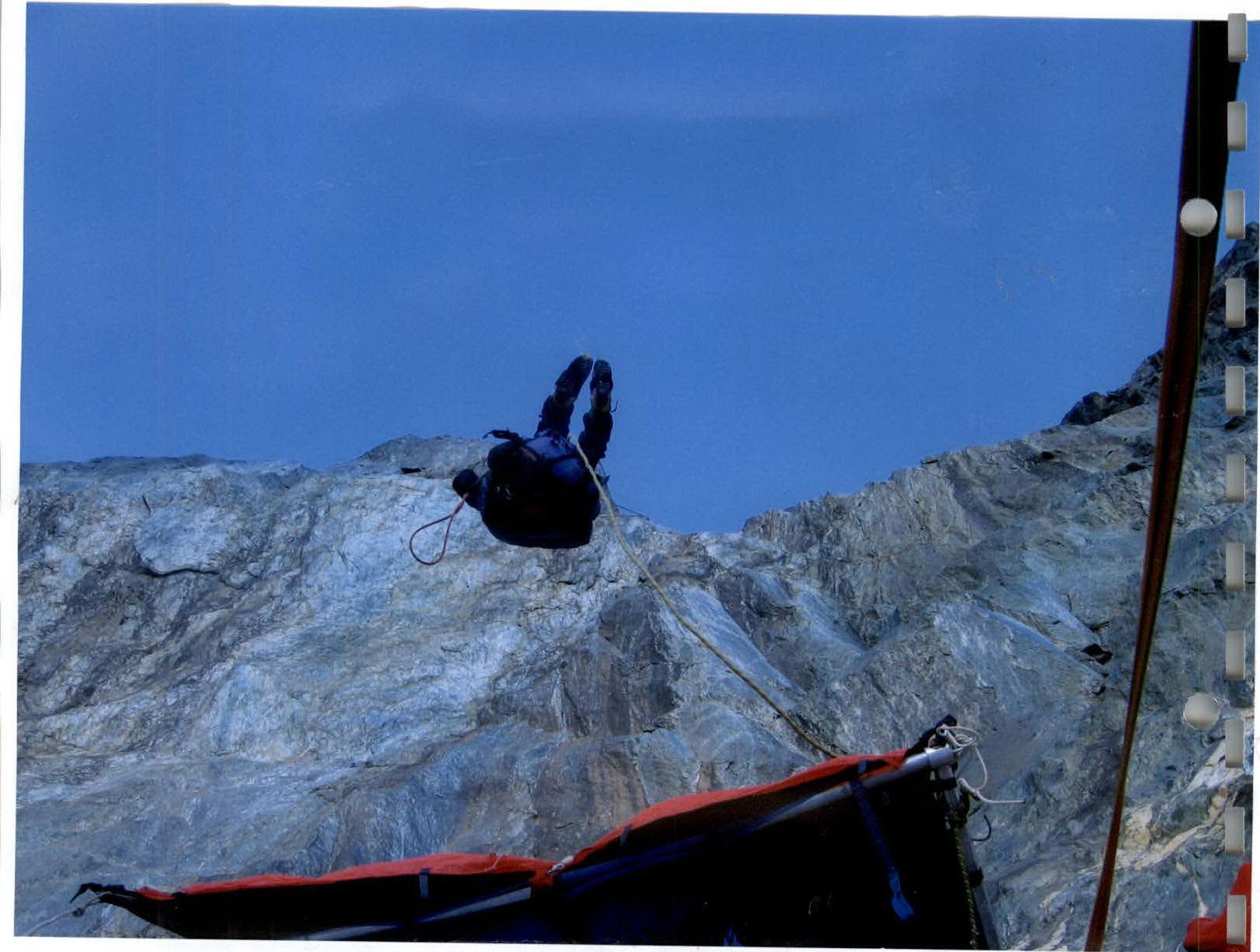
Photo # 9b. Passage of section R9–R10 along the belay
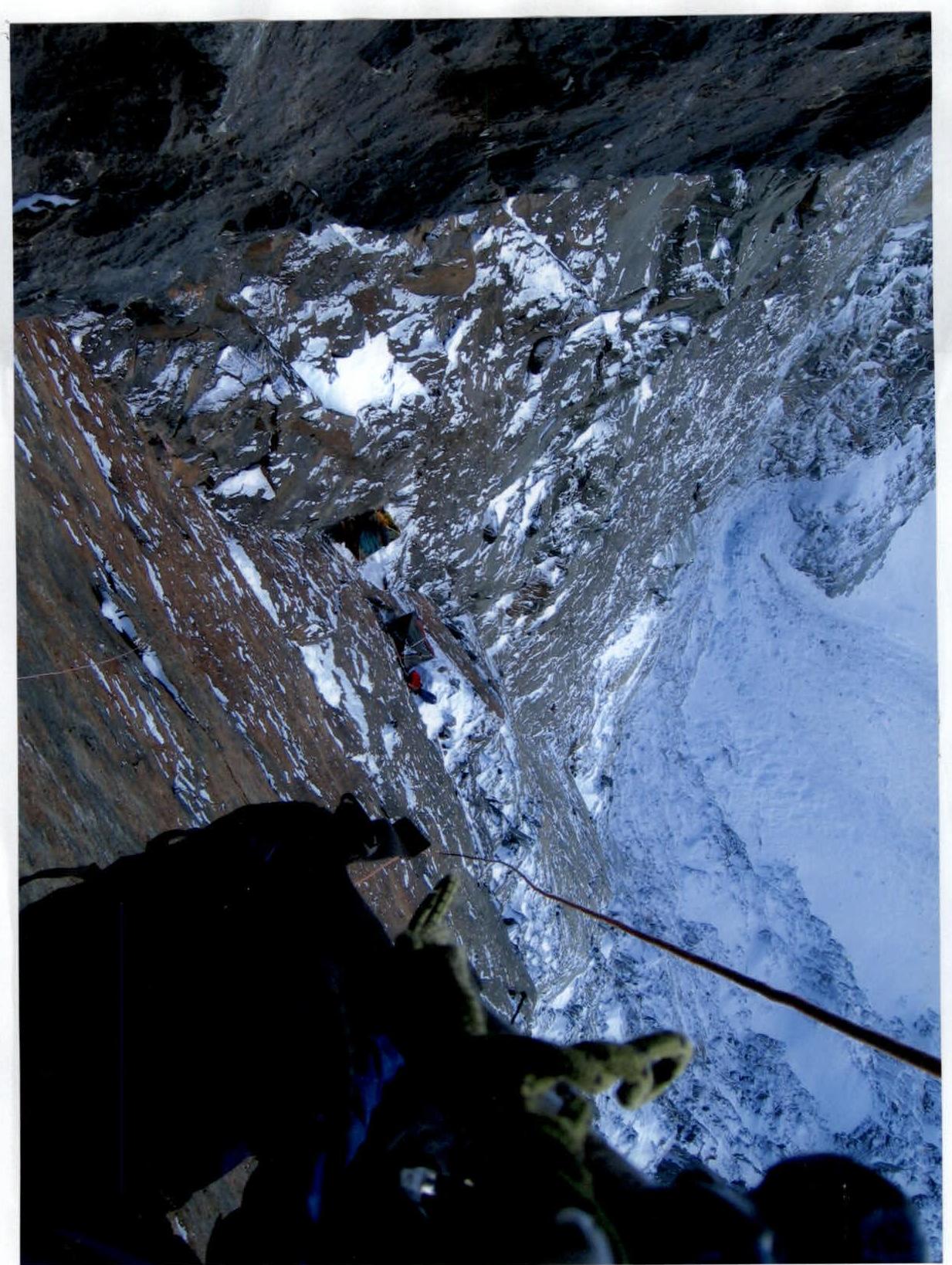
Photo # 10a. View from above of the giant inner corner from under the big corniche. Night's stay # 5 and sections R10–R13 are visible

Photo # 10b. Section R11–R14. View from below of the giant inner corner. The big corniche is visible
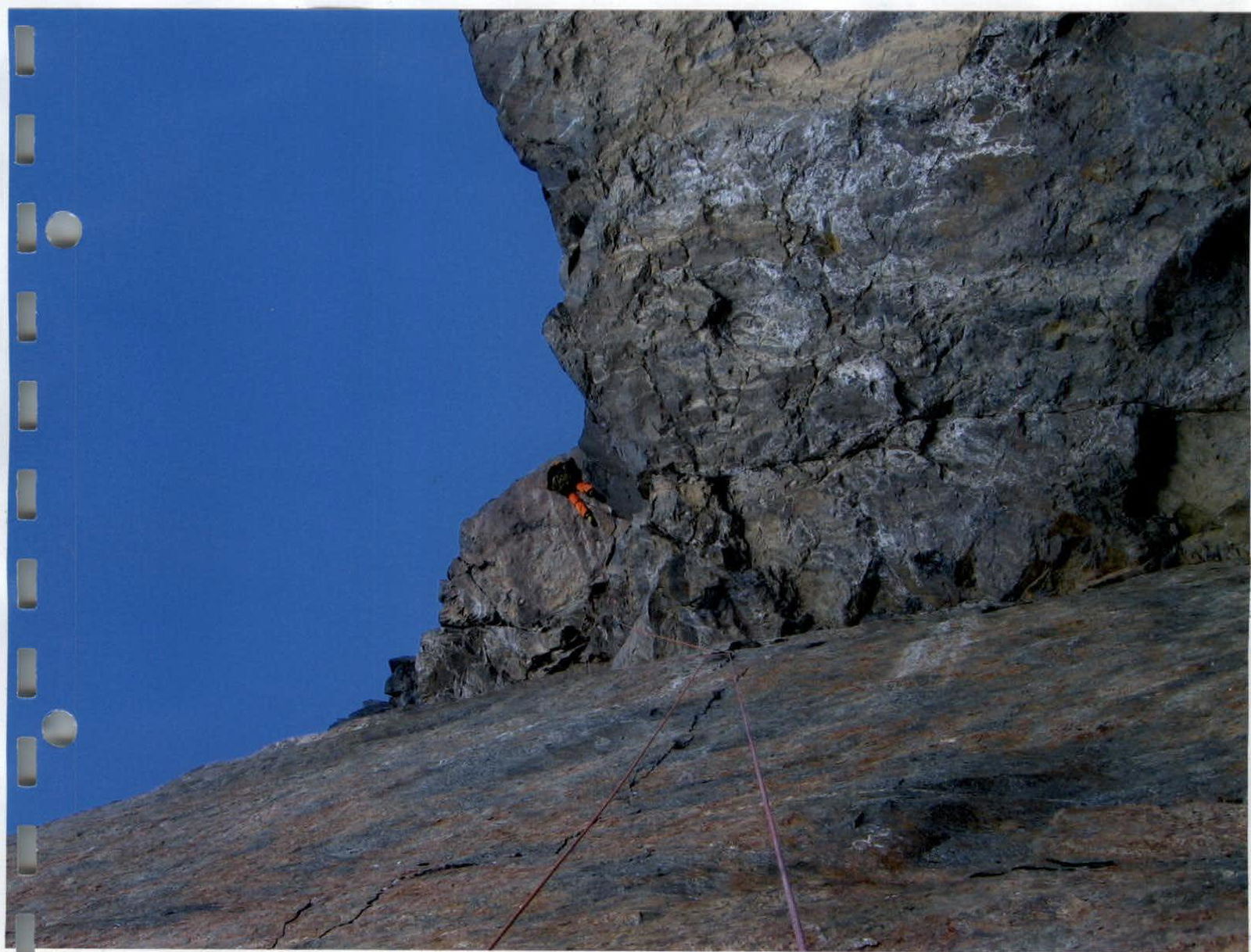
Photo # 11. Section R13–R14. Passage of the big corniche
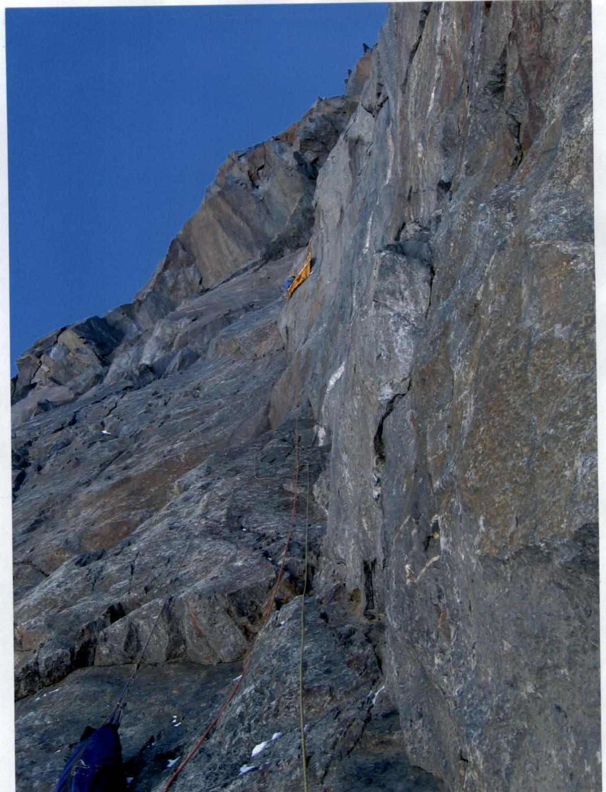
Photo # 12. Section R15–R16. "Roof". Passage of the inner corner