Russian Mountaineering Championship
High-altitude and technical class, 2023
Report
on the ascent to the summit of peak Breeze, 4430 m, via the internal corners of the northwest wall, 6B category of complexity, approximately. First ascent by the team from Krasnoyarsk from July 24, 2023, to July 25, 2023.
2023
I. Ascent Passport
| 1. General Information | ||
|---|---|---|
| 1.1 | Full name, sports rank of the team leader | Prokofyev D.E. (MS) |
| 1.2 | Full name, sports rank of participants | Popova M.E. (MS) |
| 1.3 | Full name of coach | Prokofyev D.E. (MS), Balezin V.V. (MSMK), Zakharov N.N. (MSMK) |
| 1.4 | Organization | Krasnoyarsk Regional Federation of Mountaineering |
| 2. Characteristics of the Ascent Object | ||
| 2.1 | Region | Gissar-Alay |
| 2.2 | Valley | Karavshin valley |
| 2.3 | Number of section according to the 2013 classification table | 5.4.3 |
| 2.4 | Name and height of the summit | Breeze, 4430 m |
| 2.5 | Geographical coordinates of the summit (latitude/longitude), GPS coordinates | 39°37′10″ N, 70°18′57″ |
| 3. Characteristics of the Route | ||
| 3.1 | Name of the route | Via internal corners of the northwest wall |
| 3.2 | Proposed category of complexity | 6B |
| 3.3 | Degree of route exploration | First ascent |
| 3.4 | Nature of the route terrain | Rock climbing |
| 3.5 | Height difference of the route (altimeter or GPS data) | 740 m |
| 3.6 | Route length (in meters) | 1140 m |
| 3.7 | Technical elements of the route (total length of sections of various complexity categories with indication of terrain type (ice-snow, rock)) | IV — 30 m, V-VI — 843 m, including VI — 478 m, A1 — 102 m, A2 — 300 m, A3 — 25 m |
| 3.8 | Average steepness of the route, (°) | 57° |
| 3.9 | Average steepness of the main part of the route, (°) | 76° |
| 3.10 | Descent from the summit | Southeast to the Djau-paya valley |
| 3.11 | Additional characteristics of the route | Main part of the route — A2 ITO on anchors and friends, with many loose rocks throughout |
| 4. Characteristics of Team Actions | ||
| :--: | :--: | :--: |
| 4.1 | Time of movement (team's walking hours, in hours and days) | 23 hours, 2 days |
| 4.2 | Overnight stays | 1 |
| 4.3 | Time spent processing the route | 0 hours, 0 days |
| 4.4 | Start of the route | 6:00, July 24, 2023 |
| 4.5 | Reaching the summit | 16:09, July 25, 2023 |
| 4.6 | Return to the base camp | 16:00, July 26, 2023 |
| 5. Characteristics of Weather Conditions | ||
| 5.1 | Temperature, °C | +5–+15°C |
| 5.2 | Wind strength, m/s | 1–4 |
| 5.3 | Precipitation | Rain on July 24 |
| 5.4 | Visibility, m | Clear |
| 6. Responsible for the Report | ||
| 6.1 | Full name, e-mail | Prokofyev D.E., desprok@gmail.com |
II. Ascent Description
1. Characteristics of the Ascent Object
1.1. General photo of the summit
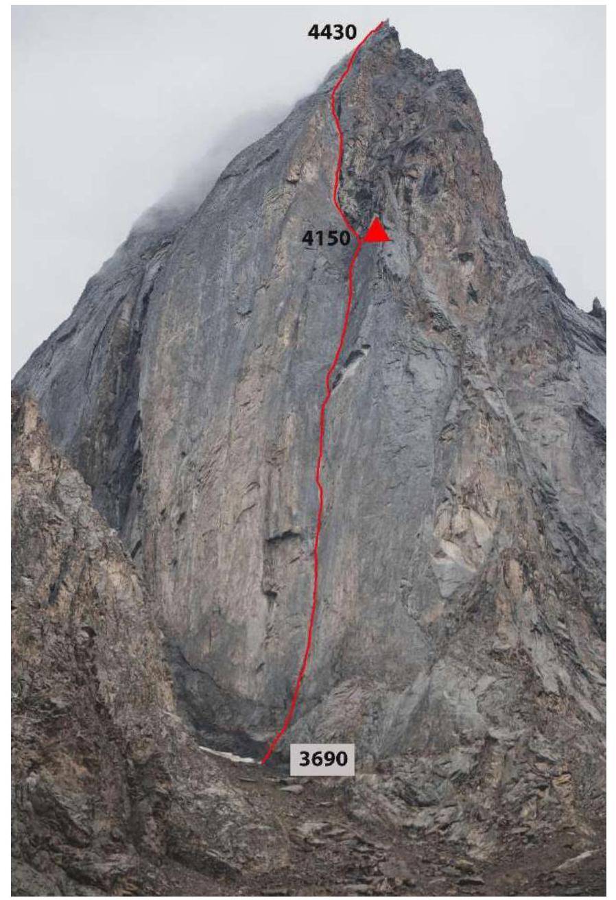
1.2. View of the route from the right

1.3. Drawn profile of the route

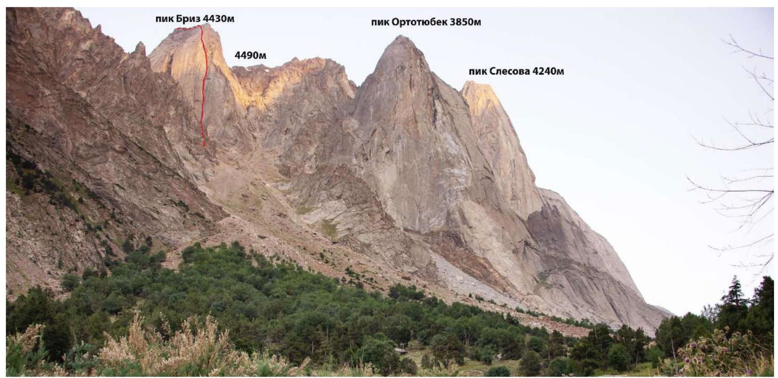
1.4. Photopanorama of the area
1.5. Map of the area
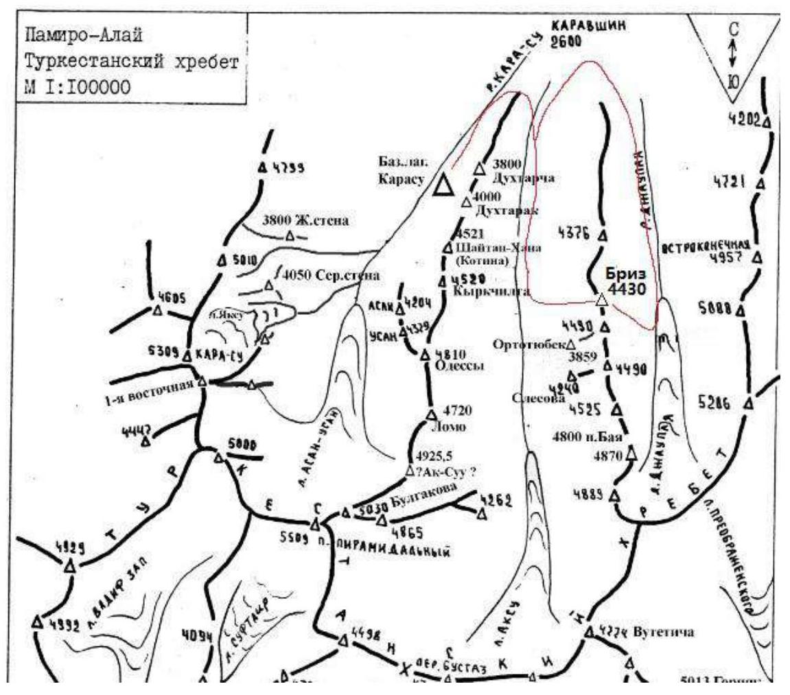
Area map. The red line indicates our approach from the Karasu camp and descent to the Djau-paya valley with subsequent return to the base camp.
2. Characteristics of the Route
2.1. Technical photograph of the route
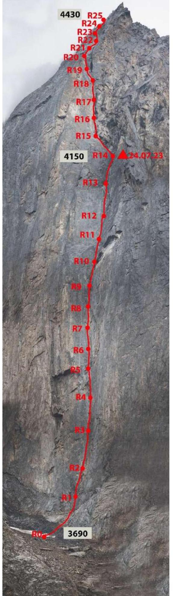
2.3. Route diagram in UIAA symbols
| Section # | Friends | Anchor Bolts | Ice Screws | Category | Section Length | Steepness |
|---|---|---|---|---|---|---|
| R25–R26 | 1 | II | 300 m | 10° | ||
| R24–R25 | 10/4 | 4 | V | 25 m | 75° | |
| R23–R24 | 8 | 7 | V | 30 m | 67° | |
| R22–R23 | 10 | 3 | IV | 30 m | 65° | |
| R21–R22 | 7 | 7 | V | 30 m | 60° | |
| R20–R21 | 6 | 8 | V | 35 m | 55° | |
| R19–R20 | 8 | 6 | V | 35 m | 65° | |
| R18–R19 | 12/2 | 6/2 | 0 | V | 30 m | 70° |
| R17–R18 | 16/10 | 6/2 | 0 | VI A1–A2 | 3, 17, 20 | 95, 80, 60 |
| R16–R17 | 12/12 | 10/10 | 1 | VI A2 | 30 m | 80° |
| R15–R16 | 12/12 | 14/14 | 1 | VI A2–A3 | 23, 10 | 95, 80 |
| R14–R15 | 12 | 9 | 1 | V | 65 m | 70° |
| R13–R14 | 7 | 10 | 0 | V A1 | 40 m | 60° |
| R12–R13 | 2 | 7/5 | 0 | V A1 | 60 m | 70° |
| R11–R12 | 10/6 | 8/8 | 1 | V A2 | 30 m | 75° |
| R10–R11 | 10/10 | 8/8 | 2 | VI A2 | 30 m | 75° |
| R9–R10 | 5/5 | 16/16 | 1 | VI A2 | 18, 7 | 80, 95 |
| R8–R9 | 7/7 | 15/15 | 1 | VI A2 | 30 m | 75° |
| R7–R8 | 1/1 | 16/16 | 1 | VI A2–A3 | 27 m | 80° |
| R6–R7 | 0 | 18/18 | 1 | VI A2 | 30 m | 70° |
| R5–R6 | 8/8 | 14/14 | 1 | VI A2 | 30 m | 80° |
| R4–R5 | 9/9 | 13/13 | 1 | VI A2–A3 | 40 m | 100° |
| R3–R4 | 9/9 | 10/10 | 1 | VI A2–A3 | 30 m | 95° |
| R2–R3 | 12/12 | 5/5 | 1 | VI A1–A2 | 35 m | 80° |
| R1–R2 | 10/10 | 10/10 | 1 | VI A2–A3 | 30 m | 85° |
| R0–R1 | 5 | 15 | 2 | V–VI (6B+) | 60 m | 60° |
3. Characteristics of Team Actions — Route Description by Sections
| Section # | Description | Photo # |
|---|---|---|
| R0–R1 | Upward along positive rocks towards a vertical crack. Many loose rocks. Very cautious climbing, sometimes on friction. Station at the start of the vertical wall. Along the way, there are huge live blocks; climbing around them requires careful movement by the second climber. 60°, 60 m, V–VI (6B+) | 1 |
| R1–R2 | Up the crack (globally a large angle) upward, sometimes the crack is not monolithic, and the rock crumbles. Then traverse right on skyhooks (3 steps) to a relatively firm crack, continuing upward. 85°, 30 m, VI (A2–15 m, A3–6 m). | 1, 2 |
| R2–R3 | Upward along the crack using friends and anchors. 80°, 35 m, (A1–25 m, A2–10 m) | 3 |
| R3–R4 | The wall starts to overhang; along an overhanging crack left-upward under a large overhang, the crack interrupts, transition via 1 skyhook under a cornice. 90–95°, 30 m, VI (A1–15 m, A2–15 m) | 3 |
| R4–R5 | The overhang is passed using a large "flake"; 5th and 6th camalots are used alternately; no room for anchors or other protection points. Then along a lighter overhang on anchors and "fifis". 100°, 8 m, A3; 95°, 32 m, A2 | 4 |
| R5–R6 | The wall becomes vertical; upward into an internal corner, station at the base of the corner. 80°, 30 m, VI (A2–20 m) | 5 |
| R6–R7 | Up the corner, protection on anchors. 70°, 30 m, VI (A2–20 m) | 5 |
| R7–R8 | The corner ends in an overhang (about 3 meters) with deep cracks; 1 skyhook, very poor protection on anchors in the cracks. 80°, 27 m, (A2–25 m, A3–2 m); 95°, 3 m, A3 | 6 |
| R8–R9 | Up vertical cracks, 75°, 30 m, VI (A2). | 6 |
| R9–R10 | Further up the same crack system through an overhang. 80°, 18 m, VI; 95°, 7 m, A2 | 7 |
| R10–R11 | Along the corner on friends, 75°, 30 m, VI (A2). | 8 |
| R11–R12 | The wall starts to ease; up cracks. 75°, 30 m, VI (A2). | 9, 10 |
| R12–R13 | Through cracks (anchors, friends) along a large corner, many loose rocks. Exit to a sloping shelf where a bivouac for 2 can be organized (many medium and large rocks on the shelf). 70°, 60 m, V–VI (A1–20 m). | 10 |
| R13–R14 | Up the corner further, exit to a saddle. The saddle between the main wall and a small "finger" (bastion). We made a flat, convenient shelf for one tent (2–3 people). The bivouac site is absolutely safe. 60°, 40 m, V (A1). | 11, 12 |
| R14–R15 | Right-upward along gentle slabs, climbing under an overhanging wall. 65°, 70 m, V | 13 |
| R15–R16 | Through an overhanging "flake"; rock crumbles; difficult to organize protection above the shelf; 1 skyhook; then through an overhang on anchors via deep cracks, moving slightly left into a vertical internal corner with live "feathers"; very complex ITO due to the destroyed relief. 95°, 23 m, VI (A2 15 m, A3 8 m), 80°, 10 m, VI, A1 | 14 |
| R16–R17 | Up the internal corner, orientation — an overhanging cornice with a wide crack. 80°, 30 m, VI (A2). | 14, 15 |
| R17–R18 | Through the cornice on large friends; then along a good crack on friends; the wall becomes gentler; exit to a good shelf. Large and medium friends. 40 m (95°, 3 m, VI (A2); 80°, 17 m, VI (A1); 60°, V, 20 m) | 15, 16 |
| R18–R19 | Movement first along a wide crack, then a wide chimney (in opposition/along the left wall). 70°, 30 m, V | 17 |
| R19–R20 | Exit left from the chimney, traverse left-upward, exit to the "roof". Many loose rocks. 65°, 35 m, V. | |
| R20–R21 | Climbing along gentle rocks (" катушки "); many loose rocks; sometimes difficult to organize protection. 55°, 35 m, V | 18 |
| R21–R22 | Movement along slabs, moving right. 60°, 30 m, V | 18 |
| R22–R23 | Bypassing a wall on the left, 65°, 30 m, IV | |
| R23–R24 | Movement towards the ridge through a series of ledges and walls; simple climbing. 67°, 30 m, V | |
| R24–R25 | Exit to the ridge through a series of ledges and walls; simple climbing. 75°, 25 m, V | |
| R25–R26 | The ridge is a series of "жандармы" made of slate rocks (basalt); moving in pairs towards the summit, bypassing obstacles on the right. 10°, 300 m, II | 19, 20 |
3. Characteristics of Team Actions
The summit of 4430 m (subsequently named "peak Breeze") was identified as promising by Denis Prokofyev back in 2014. Research and information gathering over the following years suggested that there were no ascents via the prominent northwest wall. And presumably, there were no ascents to the summit itself. We were in the Karavshin area multiple times (D. Prokofyev in 2005, 2014, 2018, 2021; M. Popova in 2014, 2018, 2021). The area is known for popular and well-trodden routes on famous peaks with clear approaches and descents, descriptions, etc. A new peak with an unknown height and a long approach remained "unopened".
In July 2023, the duo Prokofyev — Popova arrived in the area with the goal of ascending the northwest wall of peak 4430. Two weeks prior to the ascent, they completed two acclimatization overnight stays at 4000 m and an ascent towards peak Sibirskiy up to about 4400 m. They also completed a warm-up ascent of category 4B on Zhelтая Sтену (Yellow Wall) and a route by Alperin (category 5B) on peak Asan with one overnight stay under the summit ridge (about 4150 m).
They also made one trip from the Karasu base camp to carefully examine the possible route line through binoculars. The main issue was that peak 4430 is located much farther and higher from the Ak-su river than the nearby peaks Ortоtюбек and Slesova, making the peak's height (about 4100–4500 m), the distance to the possible bivouac shelf from the route start, and even the approach length from the river to the wall unclear. They chose the most logical line from the options visible.
They planned to climb in a duo as quickly as possible. Although the lower 2/3 of the line lacked visible ledges for organizing an overnight stay, they decided not to bring a wall platform — its weight would significantly slow down the second climber on the rope. They decided to start only in good weather and climb to a shelf where they could set up a bivouac. The long daylight hours in July and the team's preparation made this feasible.
- July 21, 2023: The team left the Karasu base camp, reached the green zone (just before peak Ortоtюбек), and set up a tent. They cached part of their gear approximately halfway up the couloir towards peak 4430. The ascent up the large-block scree couloir along the stream was unpleasant, becoming steeper with altitude. Then the stream turned right behind peak Ortоtюбек, and the needed couloir continued upward. They left part of their gear halfway up and returned to the tent.
- July 22, 2023: Started from the tent at 9:00, ascended the couloir with a load until 17:00. The couloir under the route line became steeper and was hit by rocks. About 1.5 hours were spent building a shelf for the tent in a safe location, practically opposite the route.
- July 23, 2023: Stormy weather forecast with heavy precipitation — they decided not to start, spent the day in the couloir in the tent.
- July 24, 2023: Began work on the route at 6:00.
3.1 Brief description of the route passage
From the bivouac, cross the couloir, move along steep "baranium lby" with a lot of sand and live blocks. Protection on anchors. Station R1 at the base of the wall.
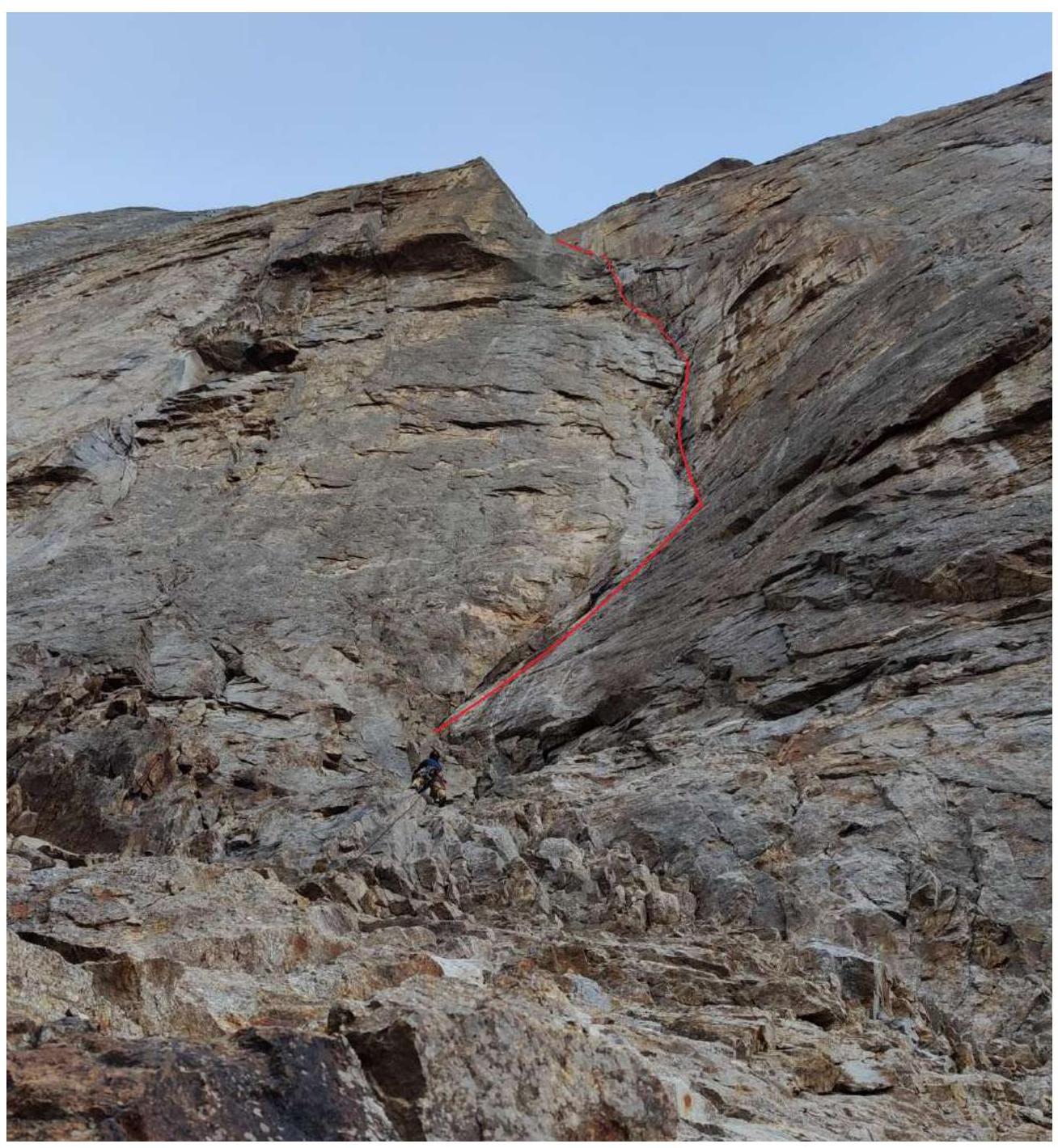
Figure 1. Leader approaches station R1. The red line indicates sections R1–R6.
From R1, move up a steep crack; the crack is not washed out by water. The rock is fragile; setting reliable points takes a long time. Then traverse about 3 meters on skyhooks under a large "naslepka". The "naslepka" is all "live"; three holes were made during the traverse. Continue moving up the crack, which becomes more reliable.
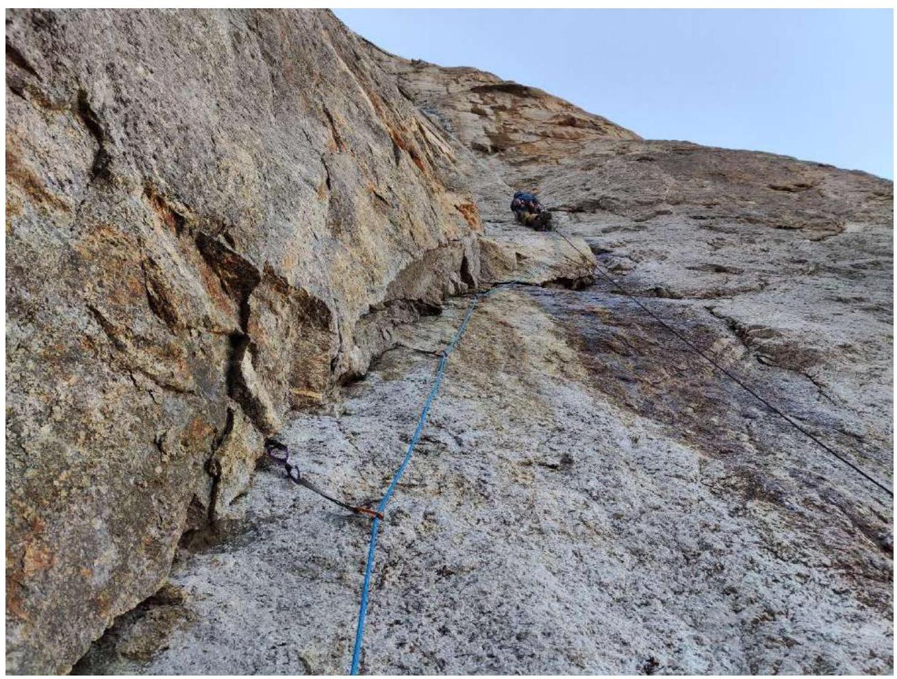
Figure 2. Leader has passed the traverse on skyhooks under the "naslepka"; the rope does not touch the wall. After 8 meters, station R2.
Up the crack on friends and anchors; water flows down the right wall after rain, making the crack more monolithic.
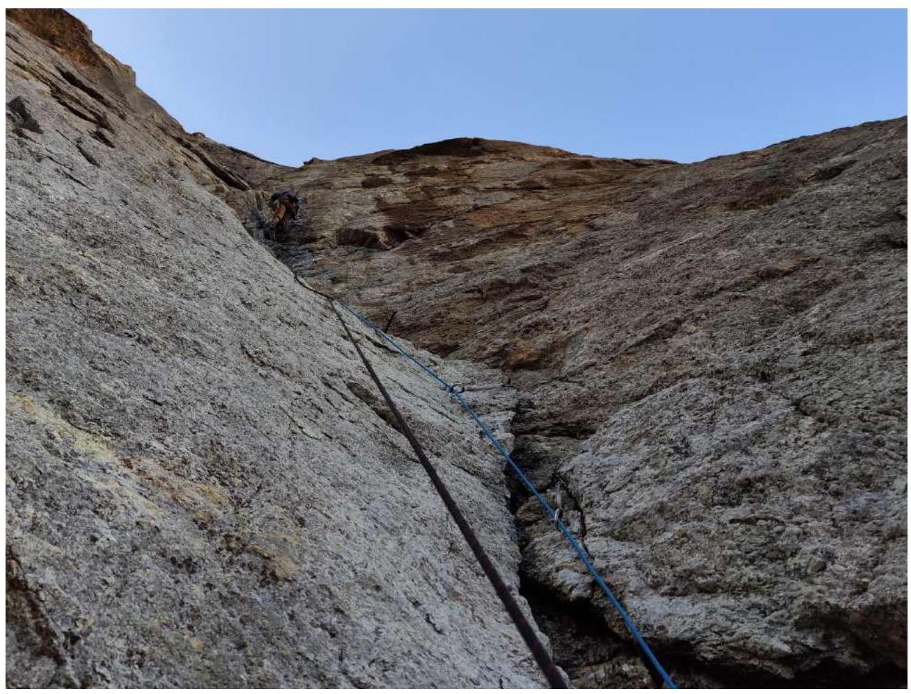
Figure 3. D. Prokofyev moves along the crack. Section R3–R4. The crack becomes steeper; after R3, a vertical and a small "puzo" at 90–93°; a hole is drilled for a skyhook to transition from one relief to another.
The wall is vertical (about 90°); approach under an overhanging wide crack. The overhang is passed quickly due to the presence of camalots #6 and #5.
After the overhang, up a steep wall along a system of blocks via the most logical relief.
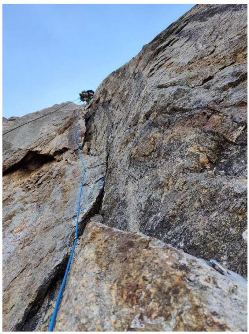
Figure 4. Passage of the overhang on large friends (sections R4–R5), photographed from station R4. The black rope is several meters from the wall.
The wall becomes slightly gentler; a large internal corner is visible. The corner has a crack for anchors and medium friends; it sometimes weakens and interrupts but is passed cautiously on anchor bolts. At the end of the corner, the relief ends; a hole is drilled for a skyhook, and then on small, unreliable anchors until good cracks for anchors. Station R8.
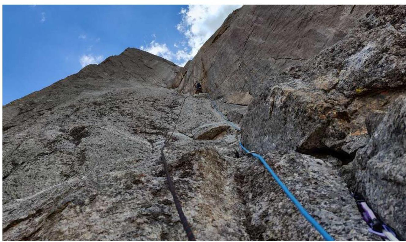
Figure 5. Start of the internal corner, sections R6–R8.
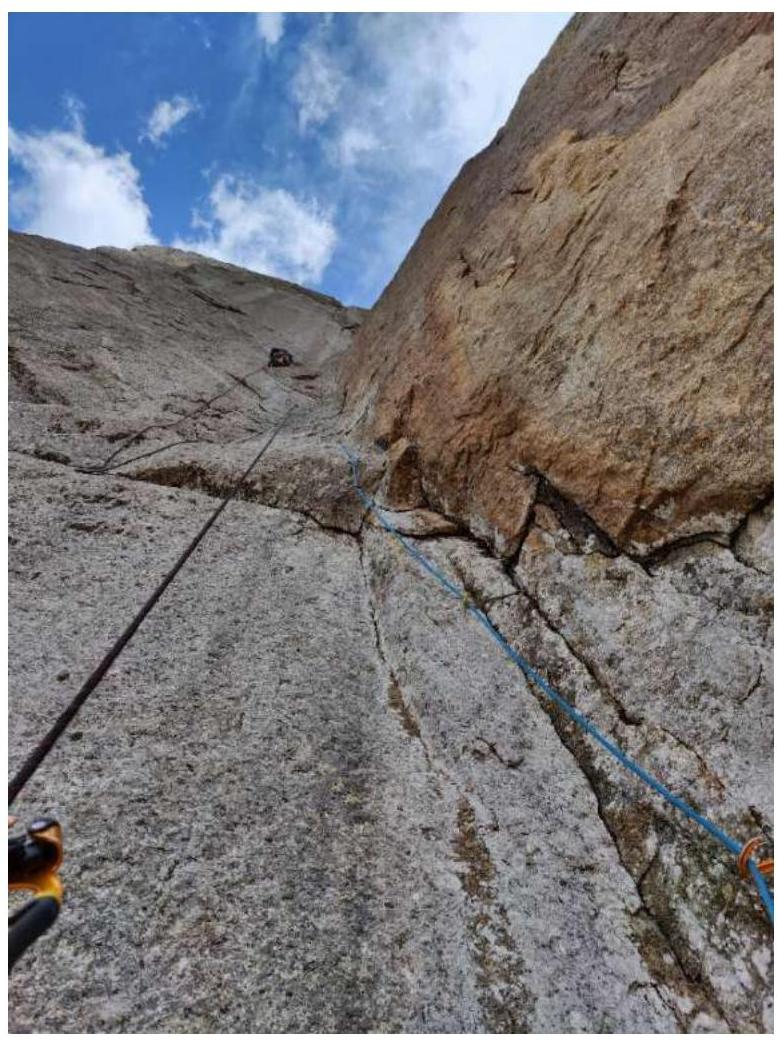
Figure 6. Leader on section R8–R9; the second climber ascends to station R8. Continue moving up this corner along a system of cracks, bypassing "live" blocks. Overhangs of 2–5 meters are encountered.
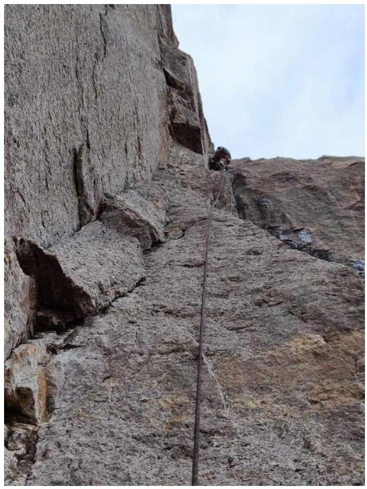
Figure 7. Section R9–R10. Then enter a vertical internal corner; on friends and anchors. Live blocks are encountered in the corner.
On short sections (5–6 meters), the wall starts to "lie down"; sub-climbing is possible; the rest is on ITO.
Figure 8. Second climber on rope R10–R11.
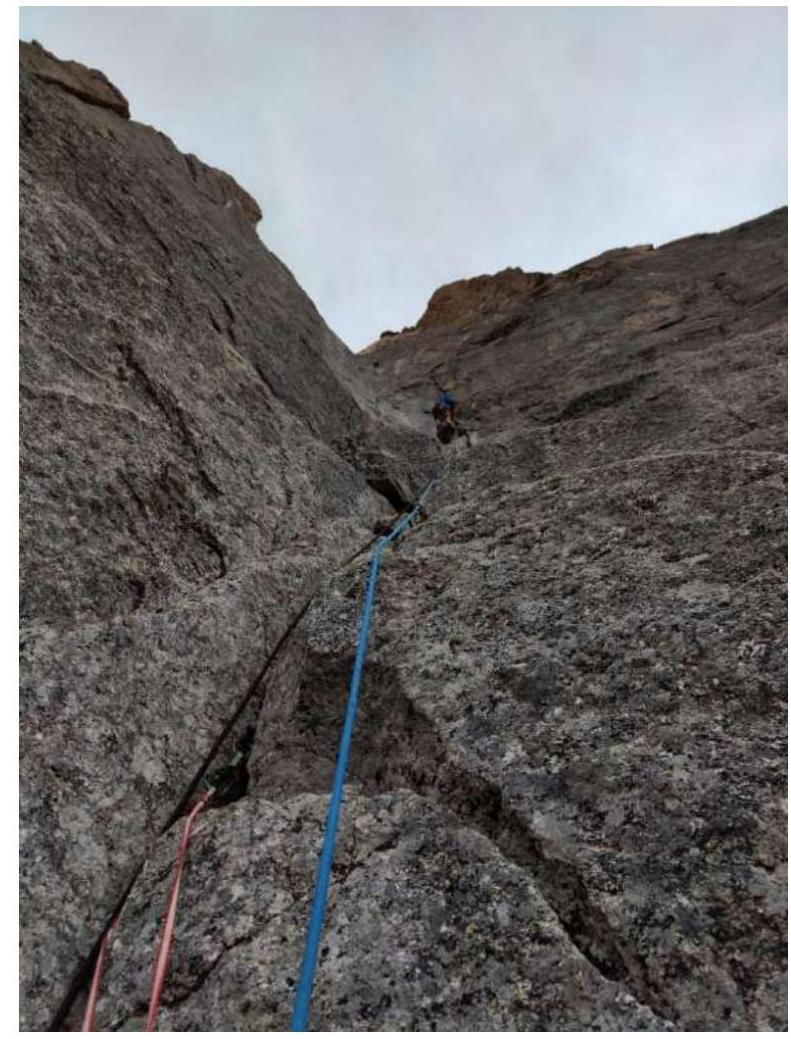
Figure 9. The wall became less steep (about 75°); some sections are climbed. Leader on section R11–R12, photographed from station R11.
At around 17:00, during the passage of section R11–R12, the weather deteriorated; a downpour and thunderstorm began. The rocks became wet; climbing even short sections became impossible. During the worst weather, no photos or videos were taken. In such conditions, they completed section R11–R12 and passed the full 60 m of R12–R13. After the rain, snow fell, and the weather improved again.
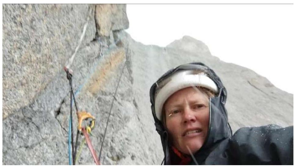
Figure 10. Snow. At station R12, the corner leads to a sloping shelf cluttered with large and medium rocks (R13). If 1.5–2 hours are spent, a platform for an overnight stay for 2 people can be built on this shelf, though not very comfortable.
They decided to climb further. 10 meters of simple rocks and then 40 meters of climbing with ITO along an angle-chimney.
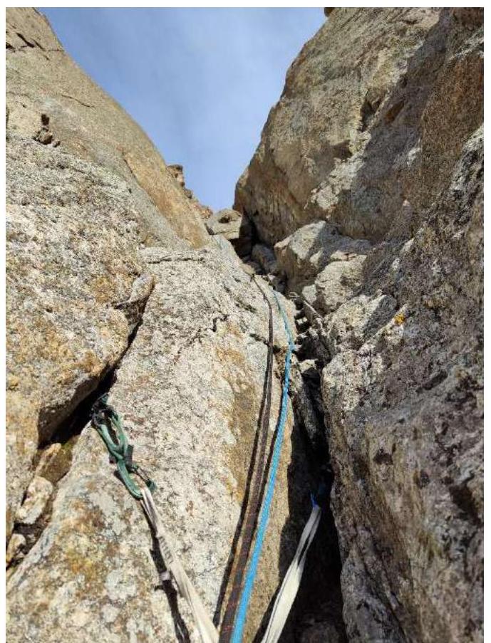
Figure 11. The section leads to the future bivouac R14. Photographed from station R13.
They exit onto a narrow saddle R14 (5×3 meters) between the main wall (left) and a sharp bastion on the right. Both climbers were on the saddle by 20:20. By 21:10, they made a platform for a tent for 2–3 people. The site is maximally safe:
- the main wall is far away;
- nothing can fall from the bastion either.
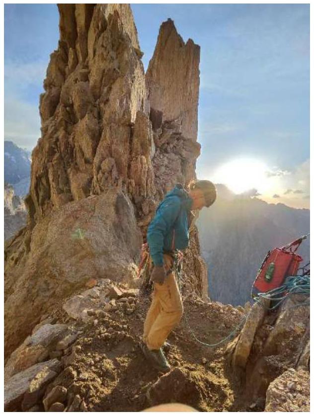
Figure 12. Platform for the tent on R14.
July 25, 2023. They started work on the route at 7:00. From the platform upward 10 meters and a traverse right 60 m along slabs. They approach a steep pre-summit tower with large blocks. Station R15 is directly under the overhang.
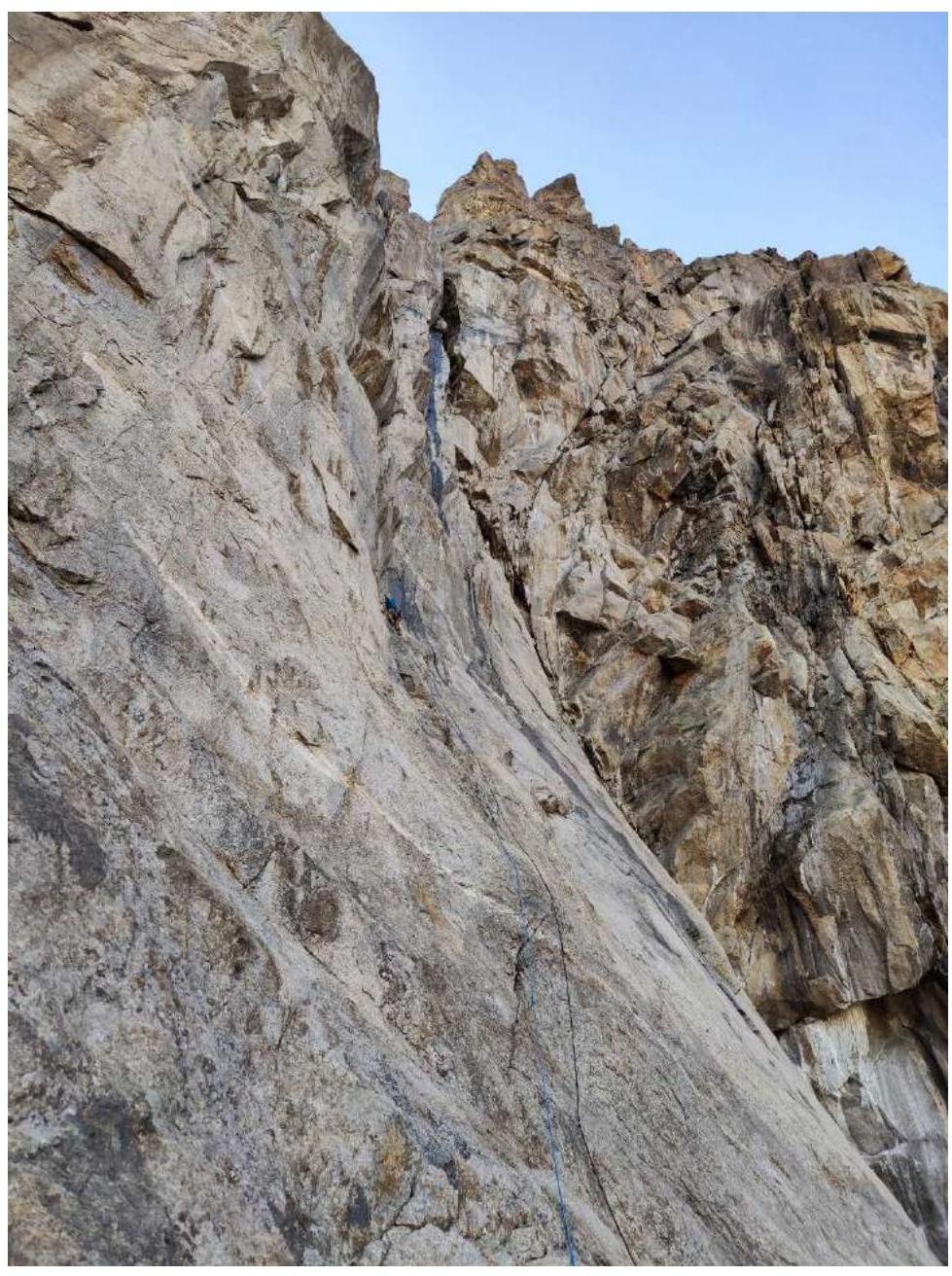
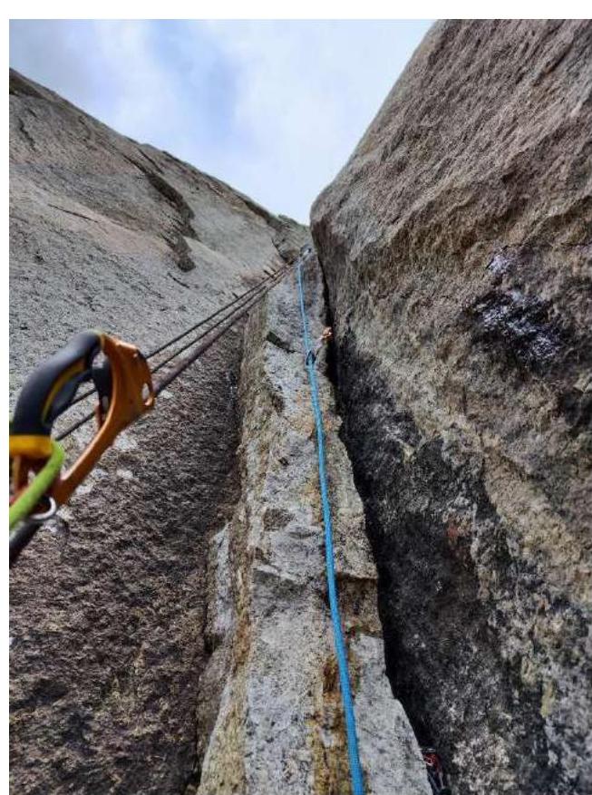
Figure 13. Leader traverses to station R15. From the station, 2 meters upward along the wall, then a transition via a skyhook into a crack. The lower part of the crack crumbles; immediate protection is not possible. A weak overhang is passed on the right wall on anchors via a series of thin cracks. Then a transition back left. Here, a vertical and many live blocks of various sizes. After them, they enter a steep internal corner. Station R16. The section is very tense, ITO A3.
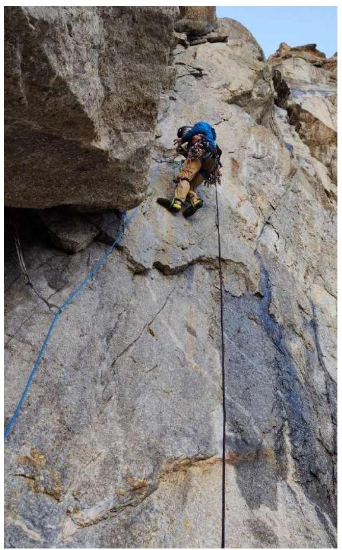
Figure 14. D. Prokofyev on the complex section R15–R16. Movement along the corner, then a transition left under a cornice; here, station R17.

Figure 15. End of the internal corner R16–R17. In the upper left part of the photo, the leader is on section R17–R18. ITO along a vertical crack.
From the station, straight up through a cornice on friends; large friends are needed (4th-5th camalots).
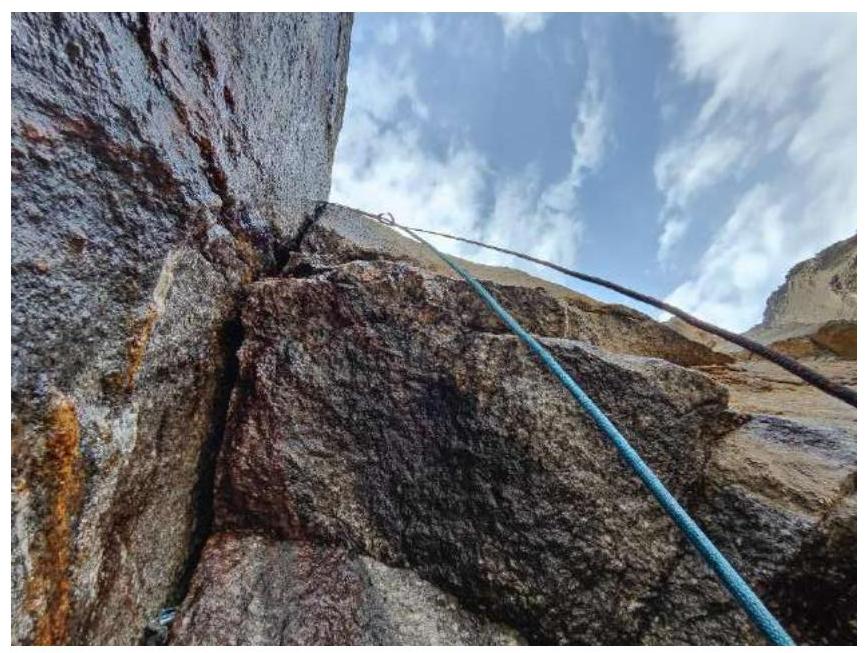
Figure 16. View from station R17 upward. Station under an overhang. Gradually, the angle eases; the last 8 meters are climbed. Station on a good shelf (R18). They gathered here. From here, the start of the "roof" is visible; everything from this section is passed by climbing to the ridge.
From the shelf, a transition right into an internal corner, which gradually becomes a wide chimney. Climbing along the left wall of the chimney (with ledges and cracks); exit left from the chimney onto the "roof". Station R19 before exiting the chimney.
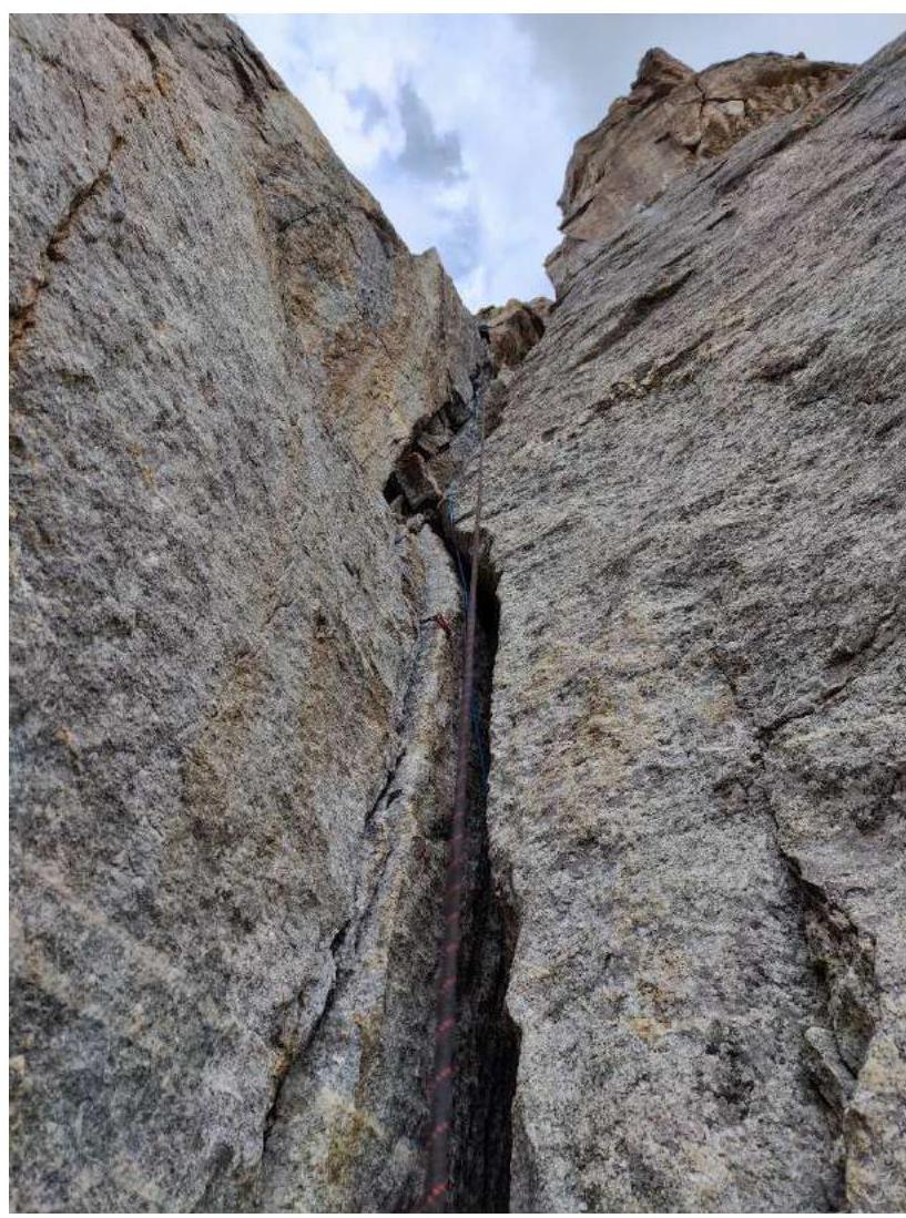
Figure 17. Ascent along a wide crack (sect. R18–R19), which later becomes a chimney; the leader is visible exiting the chimney, already above station R19.
Further movement along the "roof" on "baranium lby", orienting on relief for protection. Many live rocks; movement is always slightly away from the station.
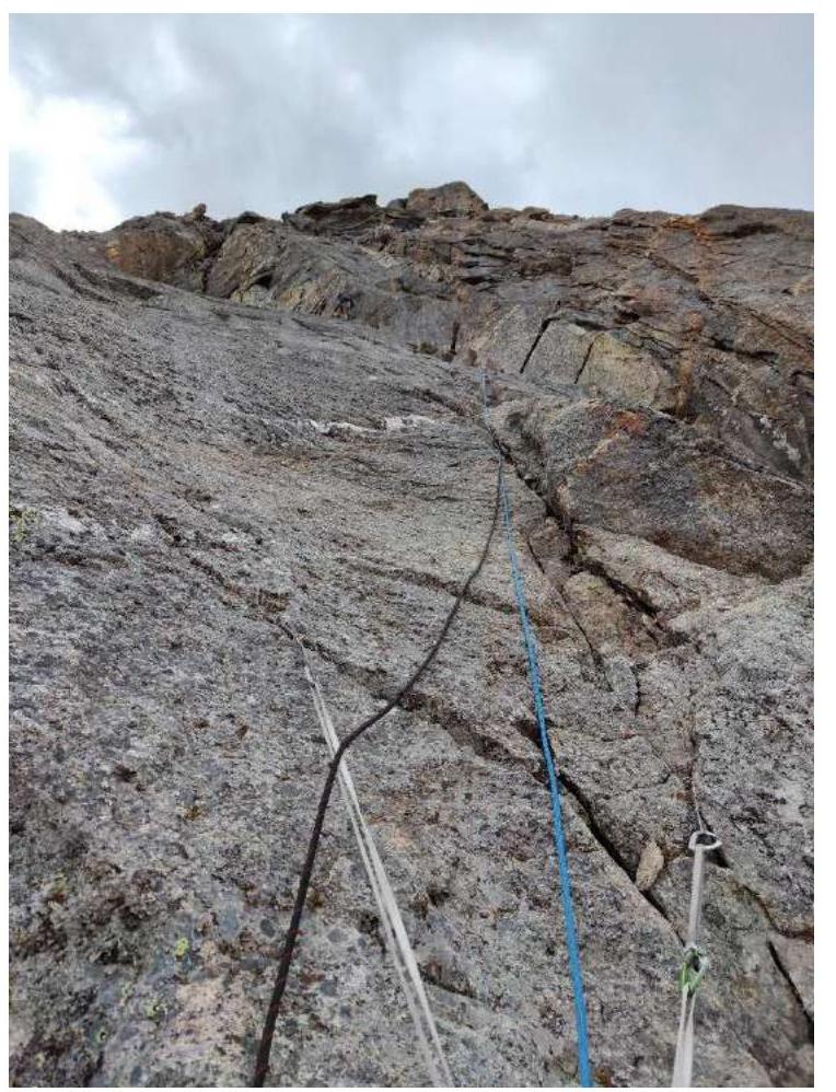
Figure 18. Passage of the "roof" section, photographed from station R21.
Exit to the ridge. The ridge is composed not of granite (like the entire wall) but of slate rocks (basalt). The ridge looks extremely destroyed but presents no technical difficulties. All "жандармы" are bypassed on the right.
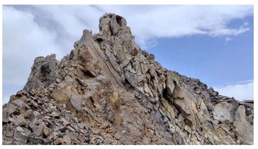
Figure 19. The ridge; left are drops onto the wall; right is gentler; all "жандармы" were bypassed on the right. The summit is not visible.
They left a "baul" ( likely a climbing protection device) at the exit to the ridge and traversed it in pairs, lightly loaded, in about 30 minutes. They reached the summit at 16:00.
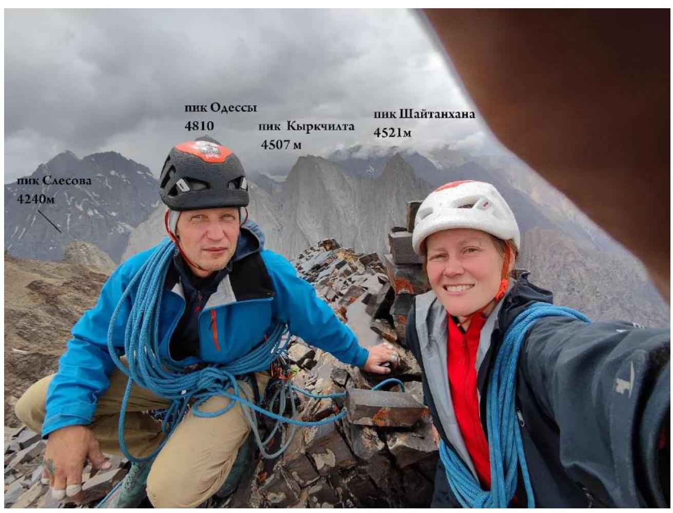
Figure 20. Photo on the summit; panorama of known peaks. They built a tour.
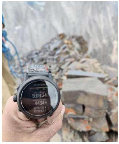
Figure 21. GPS watch; height 4434 m.


