
Passport
-
Technical category.
-
Turkestan Ridge, Ak-su gorge.
-
Peak 4774 via the center of the northwest wall.
-
Category 5B (6A) proposed, first ascent.
-
Elevation gain 830 m, length 1015 m, wall section elevation gain 645 m, length 715 m, average slope 60°, wall section slope 72°. Section lengths: category 6 difficulty – 235 m, category 5 difficulty – 330 m.
-
Pitons used:
- Rock pitons: 47 (removed: 0)
- Chocks: 151 (removed: 12)
- Bolt pitons: 6 (removed: 5)
-
Team's total climbing time: 39.5 hours, days: 3.
-
Overnights:
- 1st – uncomfortable, semi-reclined, two in hammocks.
- 2nd – comfortable, one person along the wall, without a tent.
-
Team leader: Timofeev Vladimir Nikolaevich, MS. Moroz Sergey Andreevich, MS. Khitrikov Vladimir Andreevich, MS. Lebedev Gennady Igorevich, MS. Pavlysh Sergey Nikolaevich, CMS.
-
Coach: Moroz Sergey Andreevich, MS USSR.
-
Approach to the route – July 8, 1988. Summit – July 10, 1988. Return – July 11, 1988.
-
Organization: Alpinist Club "Dnepropetrovsk" of Dnepropetrovsk Regional Council DPhSO trade unions.
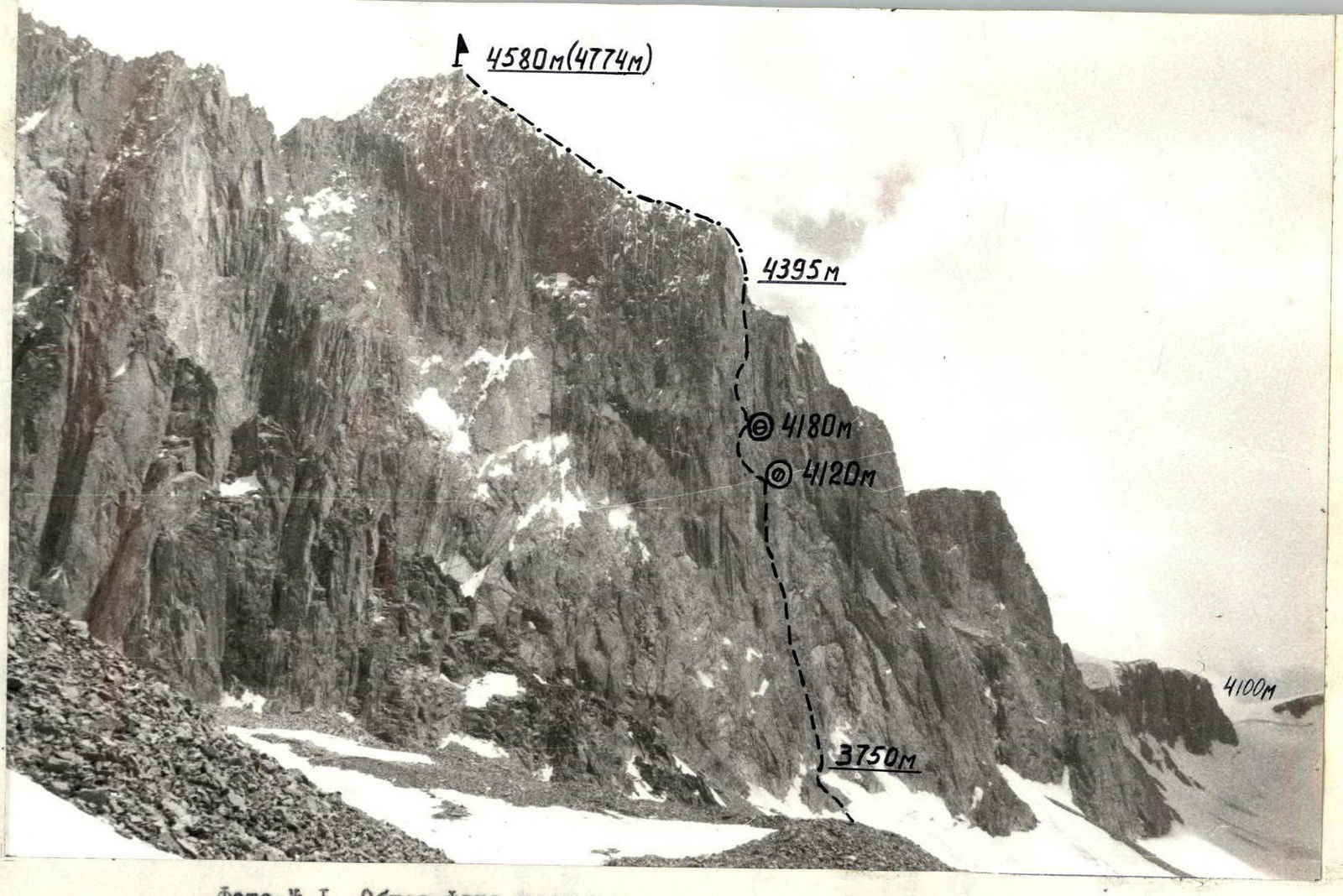
Photo #1. General photo of the summit. Date and time taken: July 8, 1988, 12:00. Lens type: Russar. F = 20 mm. Distance to the object: 2000 m. Camera point #: C1. Elevation of the camera point: 3700 m.
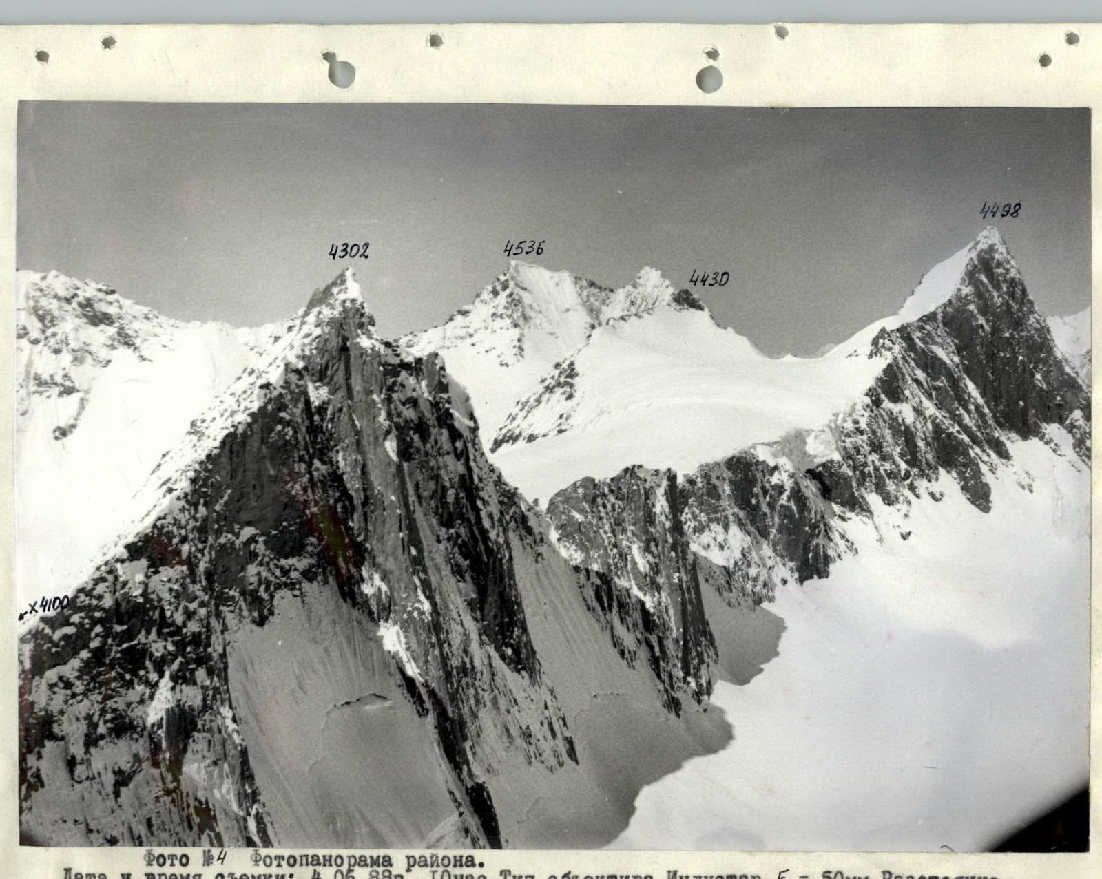
Photo #4. Photopanorama of the area. Date and time taken: June 4, 1988, 10:00. Lens type: Industar. F = 50 mm. Distance to the object: 3000 m. Camera point #: C3. Elevation of the camera point: 4000 m.

Photo #8. Technical photo of the route. Date and time taken: July 8, 1988, 14:00. Lens type: Jupiter II. F = 135 mm. Distance to the object: 200 m. Camera point #: C4. Elevation of the camera point: 3700 m.
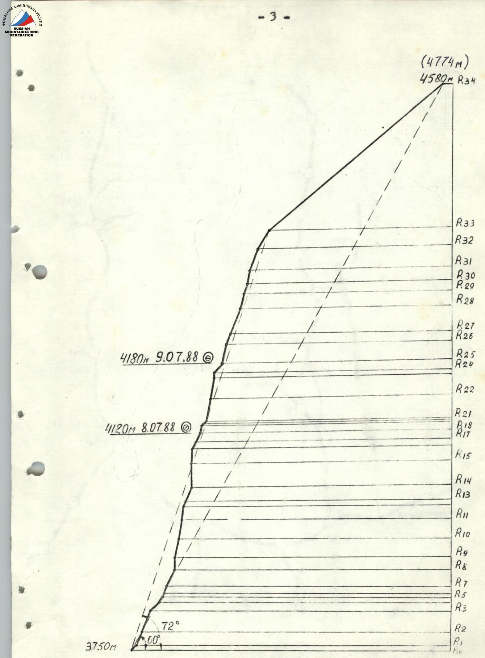
Fig. 1. Hand-drawn profile of the route. Scale 1:4000.
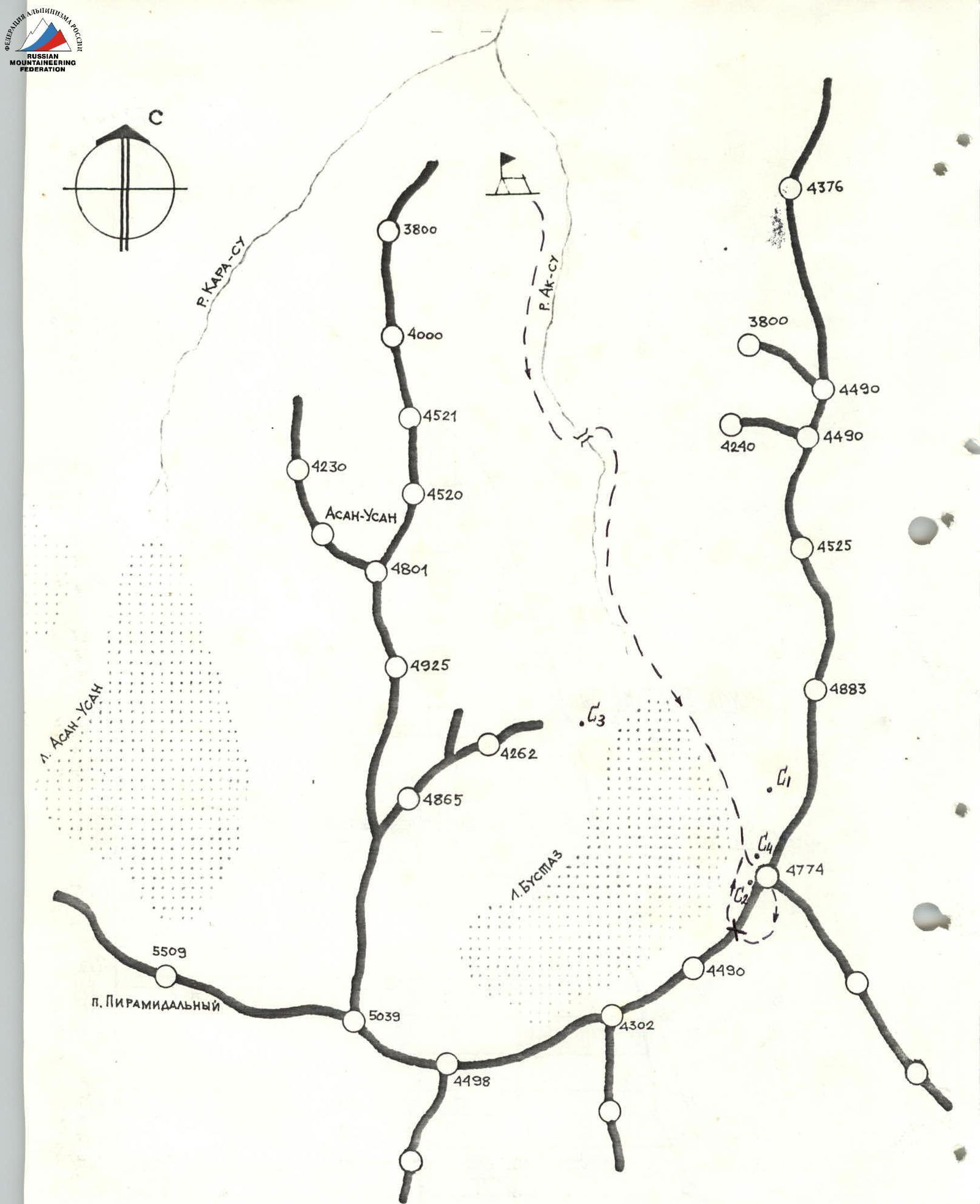
Fig. #2. Map-scheme of the ascent area. Scale 1:100000. C1–C4 – camera point numbers.
Tactical Actions of the Team
The tactical plan envisioned completing the route in three and a half days with preliminary processing of 100 m.
1st day – pass the processed section and 250 m of the route, overnight at point R18. 2nd day – pass another 100 m of the route, overnight at point R25. 3rd day – pass the tower, overnight on the ridge above. 4th day – reach the summit and descend via the pass to the camp.
The team largely followed the planned tactical plan. However, some adjustments were made during the ascent. Upon closer inspection, the upper tower was found to be composed of weathered granite with a flaking crust, making it objectively hazardous to climb. Consequently, the team deviated 30 m to the right, using the right part of the tower, which somewhat simplified the route. On the third day, after reaching the ridge and traversing 300 m of category 3–4 rock and snow, the team reached the summit at 20:30 and spent the night on the descent at a plateau. On the 4th day, as planned, the team descended to the base camp.
The division of the team into rope teams and the rotation of lead climbers by day and within the day were as follows:
| Processing day | Lebedev – Timofeev | section R0–R6 |
|---|---|---|
| 1st day | Moroz – Timofeev | section R7–R12 |
| Timofeev – Moroz | section R13–R18 | |
| Pavlysh – Timofeev | section R19–R22 | |
| 2nd day | Khitrikov – Moroz | section R23–R25 |
| Lebedev – Moroz | section R26–R27 | |
| 3rd day | Pavlysh – Lebedev | section R28–R31 |
| Timofeev – Lebedev | section R32–R33 | |
| Moroz – Timofeev | section R34 |
Each team member took turns leading, not exceeding 6 hours per day. This maintained a good pace with a normal safety margin.
The safety of the ascent was ensured through various technical and tactical measures.
- The lead climbers always used a double rope: one UIAA-rated and the other domestic.
- At belay points, all pitons were blocked with a separate loop, making it convenient to work, and all belays were interconnected.
- The team used extenders with shock-absorbing components.
- Belaying of the first climber was done through an "eight" descender.
- To simplify and speed up the second climber's ascent, the lead climber would straighten out the rope and create intermediate belay points.
- The second rope team followed the belay rope, additionally securing themselves with a team rope passed through intermediate pitons.
- The last climber used two ropes, one UIAA-rated, and utilized a titanium chain for removing pitons.
The work schedule is represented on the ascent timeline graph. The average time spent on the wall was no more than 13 hours per day.
Overnights:
- The first overnight was somewhat uncomfortable: semi-reclined, one person along the wall, and two in hammocks.
- The second overnight was quite comfortable: one person along the wall, reclined. Both overnights were safe and protected by overhangs.
Provisions:
- Overnight provisions were well-organized, with two "Yuvelir" stoves and two pressure cookers available.
- During the day, while climbing, the team relied on pocket food.
During bad weather on July 9, when snow grains were falling (on the most challenging section R23–R24), the lead climber primarily used ITO (Intermediate Technical Objects), utilizing bolt pitons.
Communication with observers was maintained visually through binoculars and with the help of a 70 RTP-2ChM radio station. Observers relayed information to the base camp. From the midpoint of the route onwards, direct communication with the base camp was established.
A joint rescue team was formed with the Kharkov gathering. The base camp constantly had a rescue team of six to ten people. There were no accidents or injuries during the ascent.
Table of food and fuel supplies
| Item | Quantity | Weight, kg |
|---|---|---|
| Honey | 1 | |
| Nuts | 1 | |
| Raisins | 1 | |
| Chocolate | 10 pcs | 2 |
| Dry sausage | 1 | |
| Tea | 1 pack | 0.1 |
| Crackers | 120 g | 1 |
| Soups | 3 packs | 0.9 |
| Candies | 0.75 | |
| 8.75 | ||
| Petrol | 2 l | 1.8 |
Total weight of backpacks without ropes upon starting the route: 45 kg.
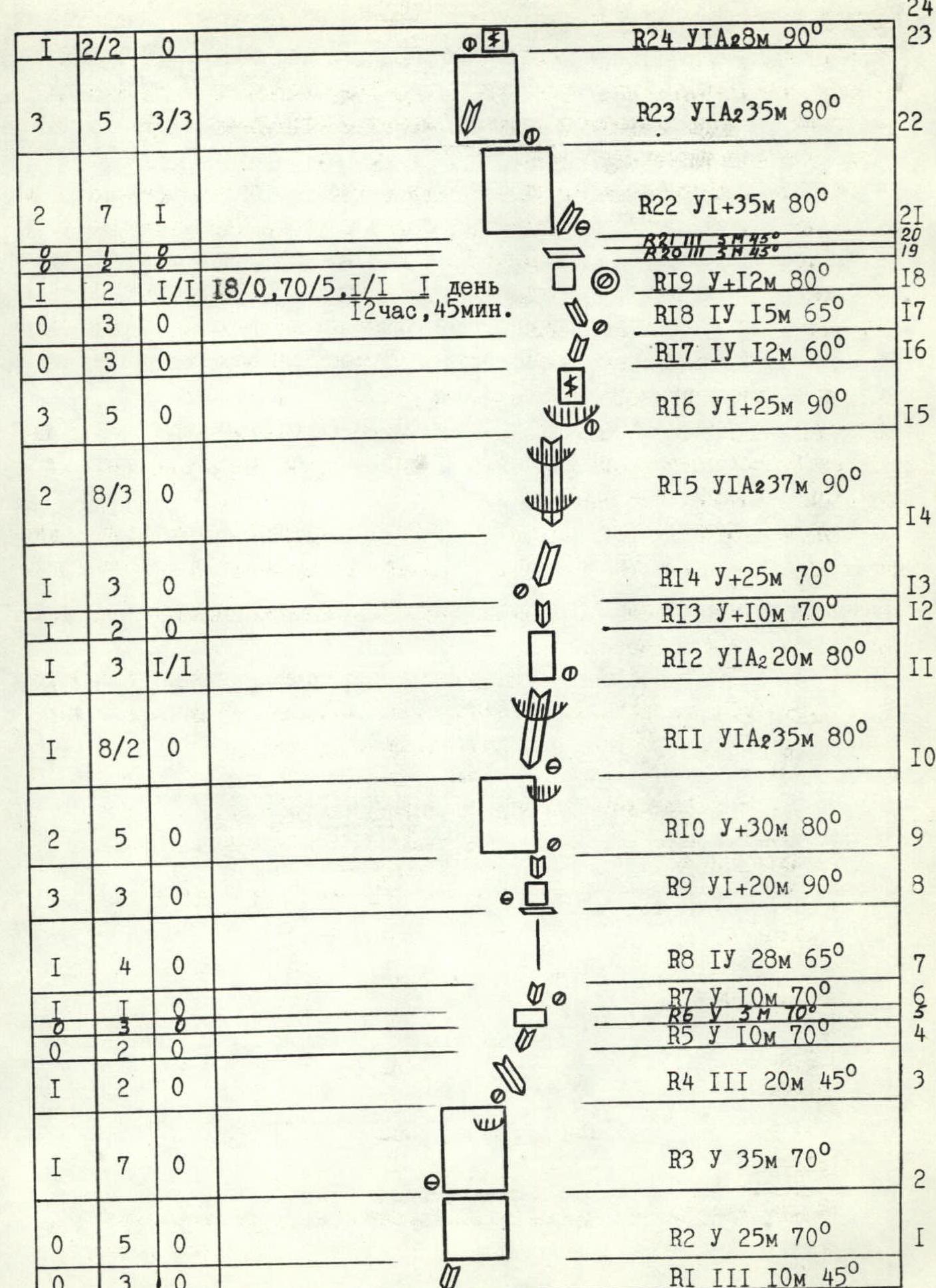
Fig. #4. Schematic representation of the route in symbols. Scale 1:2000.
| Rock pitons | Chocks | Bolt pitons | Section | Category | Length, m | Slope, ° |
|---|---|---|---|---|---|---|
| 0 | 3 | 0 | R1 | 3 | 10 | 45 |
| 0 | 5 | 0 | R2 | 5 | 25 | 70 |
| 1 | 7 | 0 | R3 | 5 | 35 | 70 |
| 1 | 2 | 0 | R4 | 3 | 20 | 45 |
| 0 | 2 | 0 | R5 | 5 | 10 | 70 |
| 0 | 1 | 0 | R6 | 5 | 3 | 70 |
| 0 | 1 | 0 | R7 | 5 | 10 | 70 |
| 1 | 4 | 0 | R8 | 4 | 28 | 65 |
| 3 | 3 | 0 | R9 | 6 | 20 | 90 |
| 2 | 5 | 0 | R10 | 5 | 30 | 80 |
| 1 | 8/2 | 0 | R11 | 6 | 35 | 80 |
| 1 | 3 | 1/1 | R12 | 6 | 20 | 80 |
| 1 | 2 | 0 | R13 | 5 | 10 | 70 |
| 1 | 3 | 0 | R14 | 5 | 25 | 70 |
| 2 | 8/3 | 0 | R15 | 6 | 37 | 90 |
| 3 | 5 | 0 | R16 | 6 | 25 | 90 |
| 0 | 0 | 3 | R17 | 4 | 12 | 60 |
| 0 | 3 | 0 | R18 | 4 | 15 | 65 |
| 1 | 2 | 1/1 | R19 | 5 | 12 | 80 |
| 0 | 3 | 0 | R20 | 3 | 5 | 45 |
| 0 | 2 | 8 | R21 | 3 | 5 | 45 |
| 2 | 7 | 1 | R22 | 6 | 35 | 80 |
| 3 | 5 | 3/3 | R23 | 6 | 35 | 80 |
| 1 | 2/2 | 0 | R24 | 6 | 30 | 90 |
| 5 | 0 | R25 | 4 | 20 | 50 | |
| 1 | 5 | 0 | R26 | 5 | 30 | 80 |
| 3 | 3 | 0 | R27 | 5 | 15 | 70 |
| 3 | 8 | 0 | R28 | 5 | 45 | 70 |
| 2 | 5 | 0 | R29 | 5 | 25 | 80 |
| 1 | 2 | 0 | R30 | 5 | 15 | 75 |
| 2 | 5/2 | 0 | R31 | 6 | 20 | 80 |
| 3 | 6/2 | 0 | R32 | 5 | 38 | 70 |
| 2 | 3 | 0 | R33 | 4 | 35 | 60 |
| 3 | 22 | 0 | R34 | 4 | 300 | 35 |
Continuation of the scheme
Description of the Route by Sections
Processing day: The approach to the route follows snow, then not very steep rock outcrops to an internal corner at R0. The starting point of the route is marked at 3750 m. Climbing the internal corner 10 m brings you under the wall with cracks going up from left to right. Section R1, led by Lebedev. Up the wall to a small ledge. The belay is quite comfortable. Further up a crack filled with water, through a small overhang, and right along a not very distinct internal corner to a sloping ledge, section R2. The belay point is uncomfortable. Then, crossing a fairly large internal corner R3, under a small steep slab and right along the internal corner R5, under a small wall R6. Small holds, done on balance.
1st day: Lead rope team Moroz–Timofeev. Up the internal corner R7 – 10 m. Then along a not very distinct counterfort – section R8, easy climbing to a sloping ledge. Comfortable belay spot. Up a very complex wall and internal corner (section R9) – exit under a steep wall. Uncomfortable belay. Along the wall (section R10) slightly left, through a small overhang (very difficult climbing) – exit to a small ledge. Uncomfortable belay. Mostly medium-sized chocks are used on this section. From here, up a steep internal corner (section R11) – ascent through an overhang (live blocks). The belay point is hanging and uncomfortable. Further right of the internal corner, as it is "live," along a very steep wall. Climbing is mostly done on balance and using ITO along a small internal corner (section R13) – 10 m ascent. Timofeev takes the lead. Uncomfortable belay. Then straight up the internal corner (section R14) to a large niche. Here, through an overhang (separate feathers) along a large internal corner, using ITO, climb straight up. In the upper part – a second overhang (section R15) – the most difficult section. Belay point on exiting the corner under the overhang on the right. Then a vertical 25 m crack – section R16 (large chocks) – leads to easy rocks (sections R17–R18), which lead to the overnight.
Its elevation is 4120 m. Here, the 1st control cairn is set. The overnight is uncomfortable: two in hammocks, others one by one on small ledges, semi-reclined. From the overnight starts a small wall, in the upper part without holds. Had to hammer in 1 bolt piton – section R19. Pavlysh leads. Then along a sloping ledge, crossing an internal corner – exit to a wall (section R22), quite steep and heavily destroyed, up left. Passage is complicated – everywhere fine granite crumbs. Hanging belay.
2nd day: Khitrikov leads first. Exit to a smooth slab – section R23. Cold, windy. In the middle of the day, snow grains started falling. The slab is climbed using bolt pitons on ITO (difficult section). In the upper part – exit to a vertical target with destroyed edges, ITO, difficult climbing – 8 m. Then along a simple internal corner – section R25 – exit to the overnight.
Its elevation is 4180 m (by parachute altimeter). The overnight was rearranged over about two hours. As a result, it was possible to settle comfortably one by one along the wall. Here – 2nd control cairn. Further, Lebedev led. From the overnight up left along the wall – 30 m (section R26, destroyed). Comfortable belay. Then along the internal corner to a small sloping ledge. Here ended the evening processing of the route.
3rd day: In the morning, Pavlysh leads first. Up the internal corner to the right, through a small overhang – section R28. Uncomfortable belay. Then almost horizontal traverse – 25 m to the right (section R29) – under a small wall (section R30). Along it – to an internal corner with an overhang (section R31, difficult spot, medium chocks). Belay on ITO. Pavlysh is replaced by Timofeev. Further along a small wall (on the right – an overhang) – exit to an internal corner using ITO. Along the internal corner – 20 m (section R32). Comfortable belay on a small ledge. From here – along a simple wall – 35 m, not steep exit to the ridge (section R33).
The elevation of the ridge exit is 4395 m by altimeter. Here – a small snack. Unnecessary ropes were hidden. Further movement was on a single UIAA "unit" rope along the slabs on the right part of the Western ridge – section R34. Continuous fog, no visibility. A snow field is crossed, and the ascent is made to the summit along steep rocks. Since there is no visibility, only the upper parts of the peaks are visible above the clouds. And in separate breaks, the surrounding mountains are visible. Taking a panorama of the surrounding mountains is practically impossible. No cairn was found on the summit. A new cairn is built. A note is left suggesting naming the peak after the famous sculptor Vutich. The height of the summit is 4580 m by our parachute altimeter.
The descent to a snow plateau to the south is quite straightforward, where a comfortable overnight in a tent was organized on the slope among the glacier. The next day, after descending from the pass, the group was back at the base camp by 17:00.
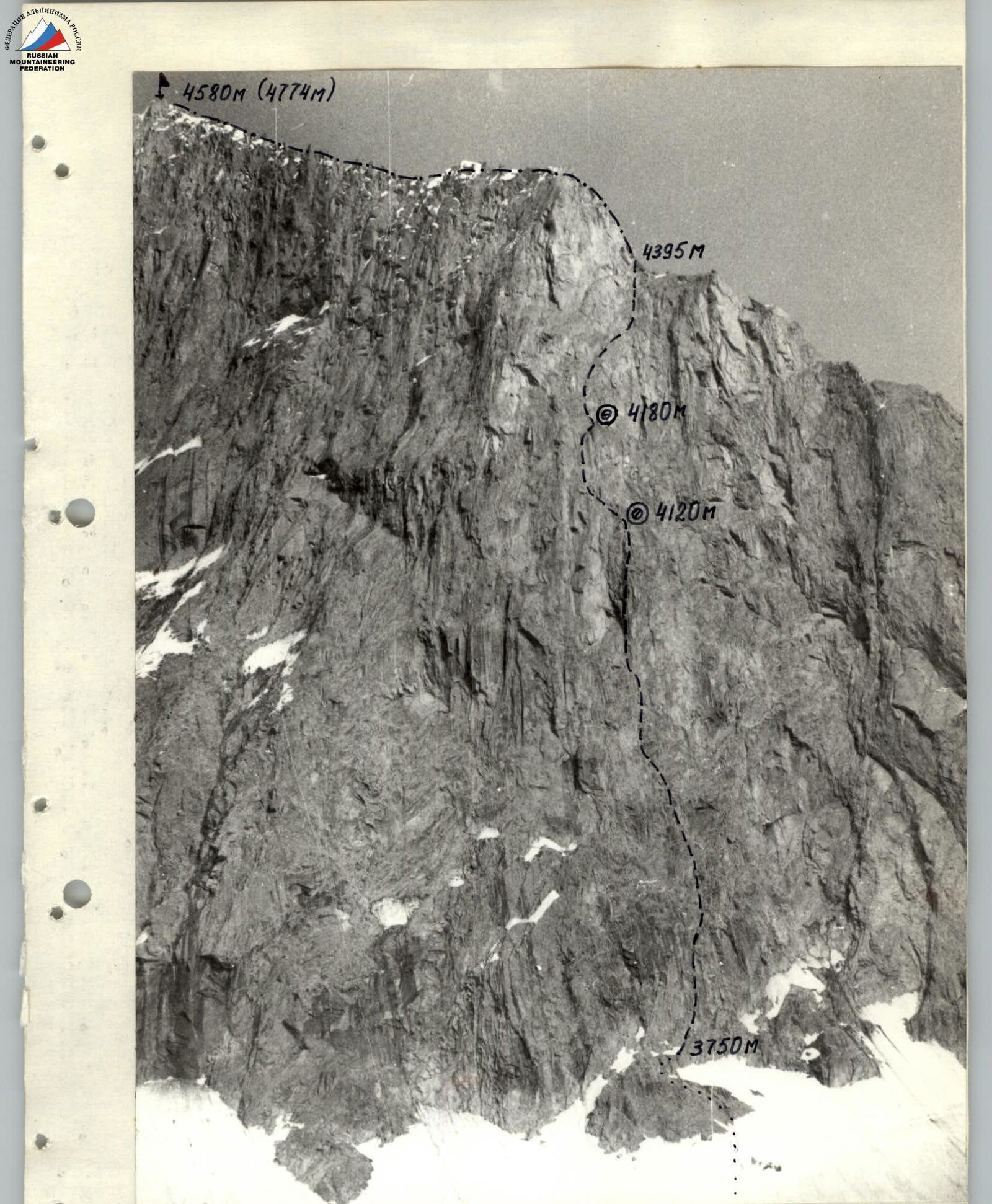
Photo #6. Wall section of the route. Date and time taken: July 7, 1988, 16:00. Lens type: Industar. F = 50 mm. Distance to the object: 500 m. Camera point #: C4. Elevation of the camera point: 3700 m.
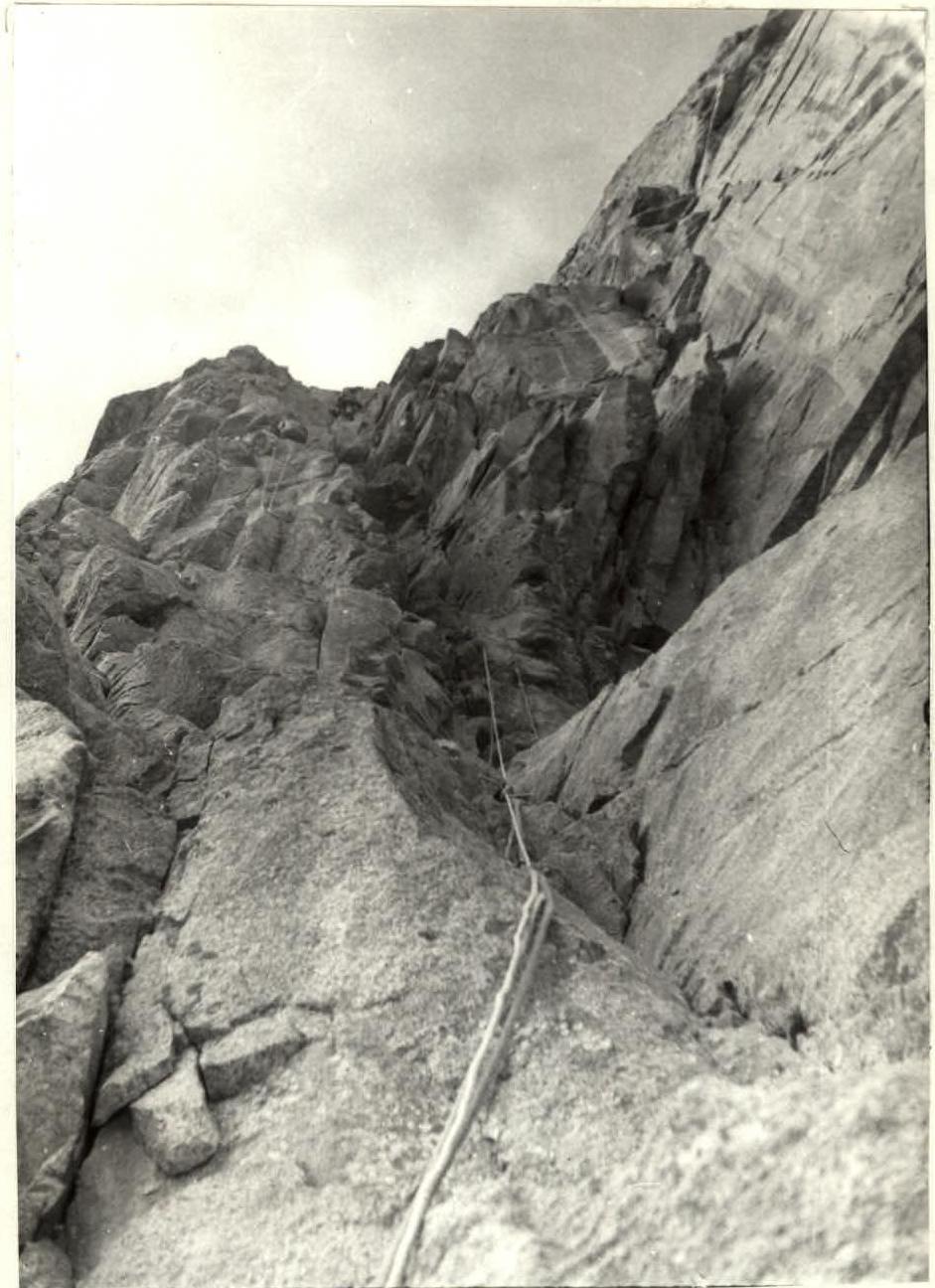
Photo #10. Section R15–R16. Most difficult internal corner. The belay point under the overhang is visible. Taken on July 8, 1988, at 17:00. Lens: Olympus. F = 35 mm.
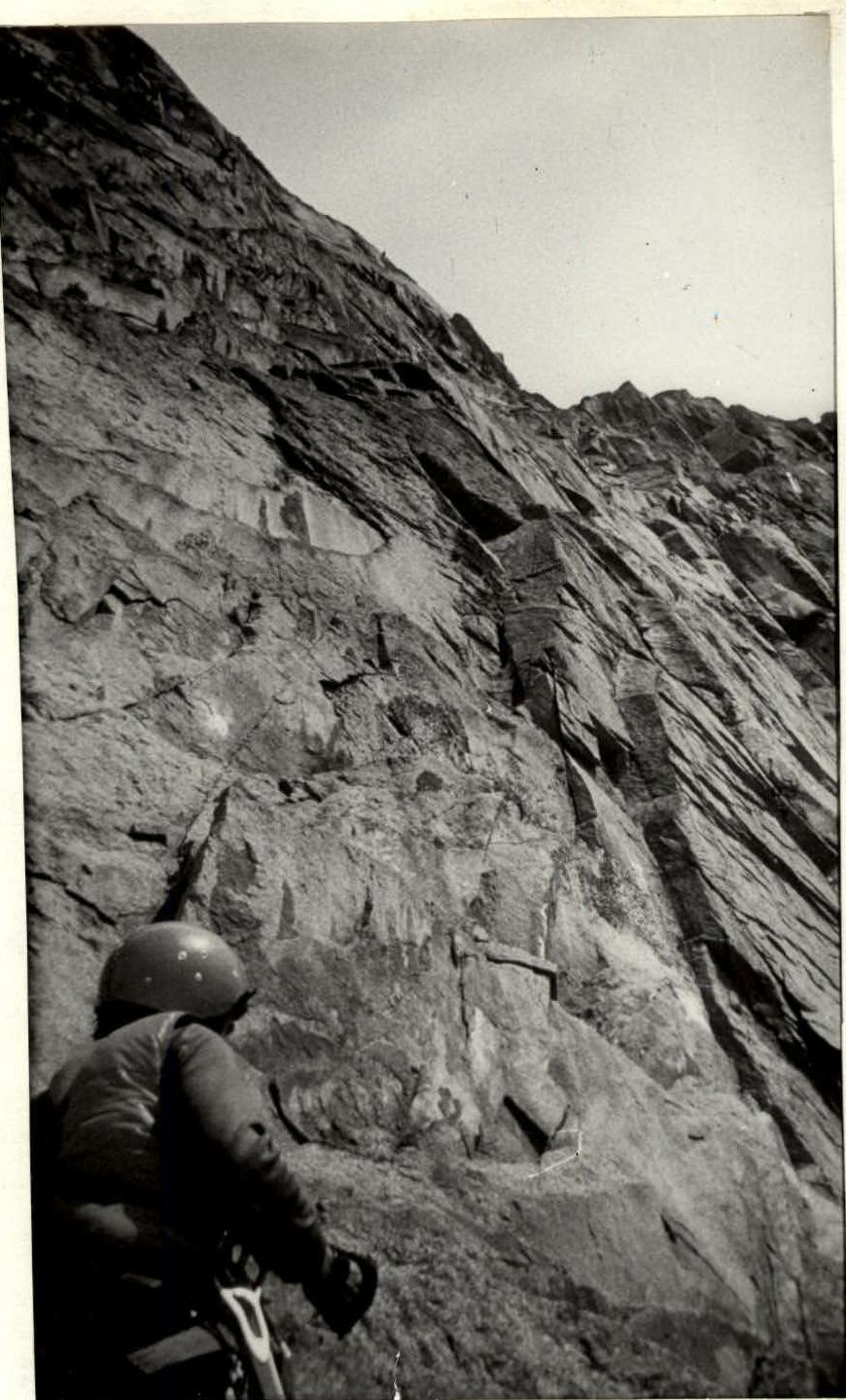
Photo #12. Section R26–R31. The "scaly" structure of the rocks is visible. Taken on July 10, 1988, at 9:00. Lens: Olympus. F = 35 mm.