Ascent Log
pr 59076
- Ascent category — traverse
- Ascent area — Pamir-Alay, Turkestan Range.
- Peaks — 4430–4490–4420–4240 m, traverse.
- Proposed — 4A cat. dif., combined, first ascent
- Length — 3000 m.
Length of sections of IV cat. dif. — 320 m.
- Pitons driven — rock (9), chocks (8)
- Climbing hours — 28, 2 days.
- Leader — Sergey G. Kritsuk — 1st sports category
Participants:
- Oleg S. Klonin — Candidate for Master of Sports
- Kirill K. Krupsky — Candidate for Master of Sports
- Andrey P. Sagurov — 1st sports category
- Ivan V. Gurianov — Candidate for Master of Sports
- Coach — Yevgeslav I. Glushko — Candidate for Master of Sports
- Group of climbers from the "White" Alpine Club
- Departure for the route — June 14, 1938.
Summiting the peaks — 4430 — June 14, 4490, 4420, 4240 — June 15. Return to camp — June 15, 1938.
The ascent to the saddle between peaks 4525 and 4430 goes through snowfields, scree, and severely destroyed shale rocks. It is necessary to move along the stream — the left tributary of the AkSu River, which flows into it below the last juniper grove above the waterfall. The ascent from the juniper grove to the saddle takes about 6 hours.
Section R0–R1: Ascent to peak 4430. Sticking to the more gentle eastern slopes (leaving the sub-summit to the left), we move through severely destroyed rocks. 250 m, 30–50°, II.
Section R1–R2: Descent from peak 4430 to the saddle between 4430 and 4490. Leaving the ridge to the left, we move along the eastern slopes, which are an alternation of severely destroyed ridges and snowfields with a steepness of about 40°. The gray-red gendarme located above the saddle can be bypassed on the left or approached head-on. Movement on this section is simultaneous, with protection via rock outcrops. 350 m, 35–45°, II. There are convenient places for overnight stays on the saddle.
Section R2–R3: Traverse of the ridge from the saddle to the sub-summit of peak 4490. We leave the ridge to the left, moving along snowy slopes (possibly icy at the end). When moving through snow (especially in the second half of the day), it is necessary to consider the avalanche danger. 280 m, 25–35°, III–IV.
Section R3–R4: Ascent to the sub-summit of peak 4490. We ascend the southeast slope of the sub-summit via slabs to its eastern ridge. 40 m, 60°, IV. Then, along the ridge, we reach the sub-summit, 40 m, 50°, IV. Protection is via pitons. Movement is alternating.
Section R4–R5: Along the ridge, we reach peak 4490. 80 m, 30°, II.
Section R5–R6: Descent from peak 4490. We move along the ridge that rises above the saddle between 4490 and 4420, bypassing the gendarme on the left. 300 m, 20–40°, II–III.
Section R6–R7: Descent from the gendarme to the saddle via rappel. 50 m, 50–65°, III.
Section R7–R8: Ascent to peak 4420 and descent to the saddle between 4420 and 4240. This is done along snowy and scree slopes with a steepness of up to 30°. 500 m, 20–30°, II.
Section R8–R9: Traverse under the summit pinnacle of peak 4240. We stick to the southeast slopes. 150 m, 30°, II.
Section R9–R10: Ascent to the summit pinnacle of peak 4240. We move through a dissected wall, using protection via pitons and chocks. 160 m, 50–60°, IV.
Section R10–R11: Descent from the summit pinnacle of peak 4240 is done using a rope (sporting style). When moving along the ridge, protection is via rock outcrops. 160 m, 50–60°, IV.
Section R11–R12: Traverse of the ridge to the saddle between 4420 and 4240. 150 m, 20–30°, II.
Section R13–R14: Descent from the saddle between peaks 4420 and 4240 to the AkSu River valley. We cross a snowy slope (attention! avalanche danger) in the direction of the cirque under peak 4490. Through a not very pronounced ridge, we enter the cirque (from which a stream originates, cascading into the AkSu valley as a waterfall), and along the scree and snowy slopes of the cirque, we descend to the "ram's foreheads." Here, a 40 m rappel onto a snowfield (attention! rockfall danger). Then, along scree and snowfields, we descend to the waterfall, leaving it to the right, and continue the descent through a system of ledges. On the steep sections of the wall, there are two rappels — the upper one is 40 m, and the lower one is 30 m. 1000 m, 30–70°, I–IV.
Descent in bad weather is not recommended, as the likelihood of rockfalls on the "ram's foreheads" increases significantly during such times.
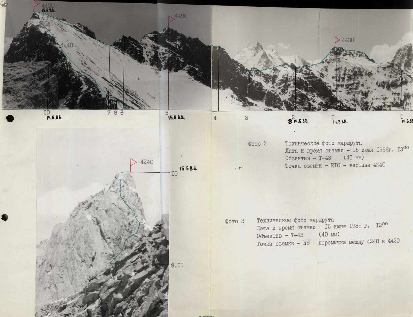
Photo 2. Technical photo of the route
- Date and time of shooting — June 15, 1988, 13:00
- Lens — T-43 (40 mm)
- Shooting point — R10 — peak 4240
Photo 3. Technical photo of the route
- Date and time of shooting — June 15, 1988, 12:00
- Lens — T-43 (40 mm)
- Shooting point — R8 — saddle between 4240 and 4420