Ascent Passport
- Region — Kyrgyzstan, Pamir-Alay, Karavshin Valley (Kara-Su river basin) 5.4.3.
- Peak — Silver Wall, South Summit 3850 m, via East Buttress
- Proposed — 4A category of difficulty, first ascent
- Route type — rock climbing
- Route characteristics:
elevation gain of the main part — 600 m,
route length — 800 m.
length of sections with 5th category of difficulty — 75 m, 4th category of difficulty — 370 m
average steepness of the main part — 52°
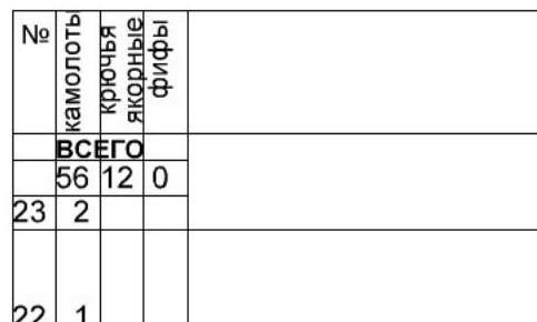
- Equipment used on the route: anchor pitons — 12, camalots — 56
- Total climbing hours — 6.5 hours, Days — 1.
- Team leader: Alexander Zhigalov Vladimirovich, Master of Sports
Team members: Anastasia Yermishina Igorevna, Candidate Master of Sports
- Team coaches:
Valery Balezin Viktorovich, International Master of Sports, Honored Coach of Russia
Nikolai Zakharov Nikolaevich, International Master of Sports, Honored Coach of Russia
- Departure date:
On the route — at 10:50, August 11, 2014
On the summit — at 17:20, August 11, 2014
Return to Base Camp — at 21:30, August 11, 2014
- Ascent organized by — Ministry of Sports and Tourism of Krasnoyarsk Krai
2014
g.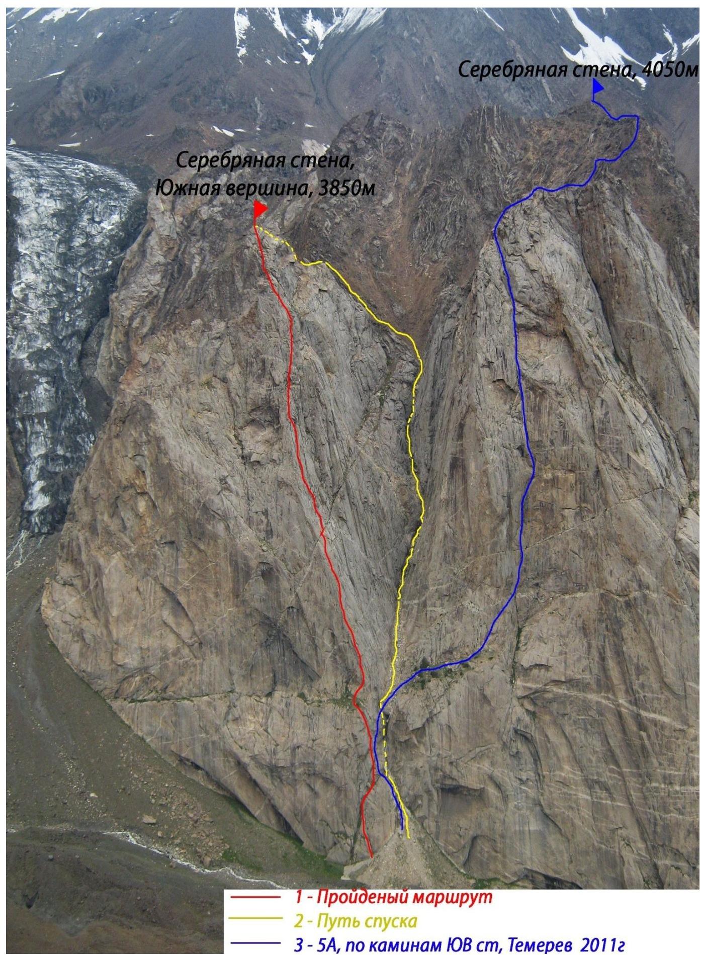
1 — Climbed route, 2 — Descent route, 3 — SA, via SE wall chimneys, Temerev 20112
Silver Wall, South Summit
3850 m,
11.08.14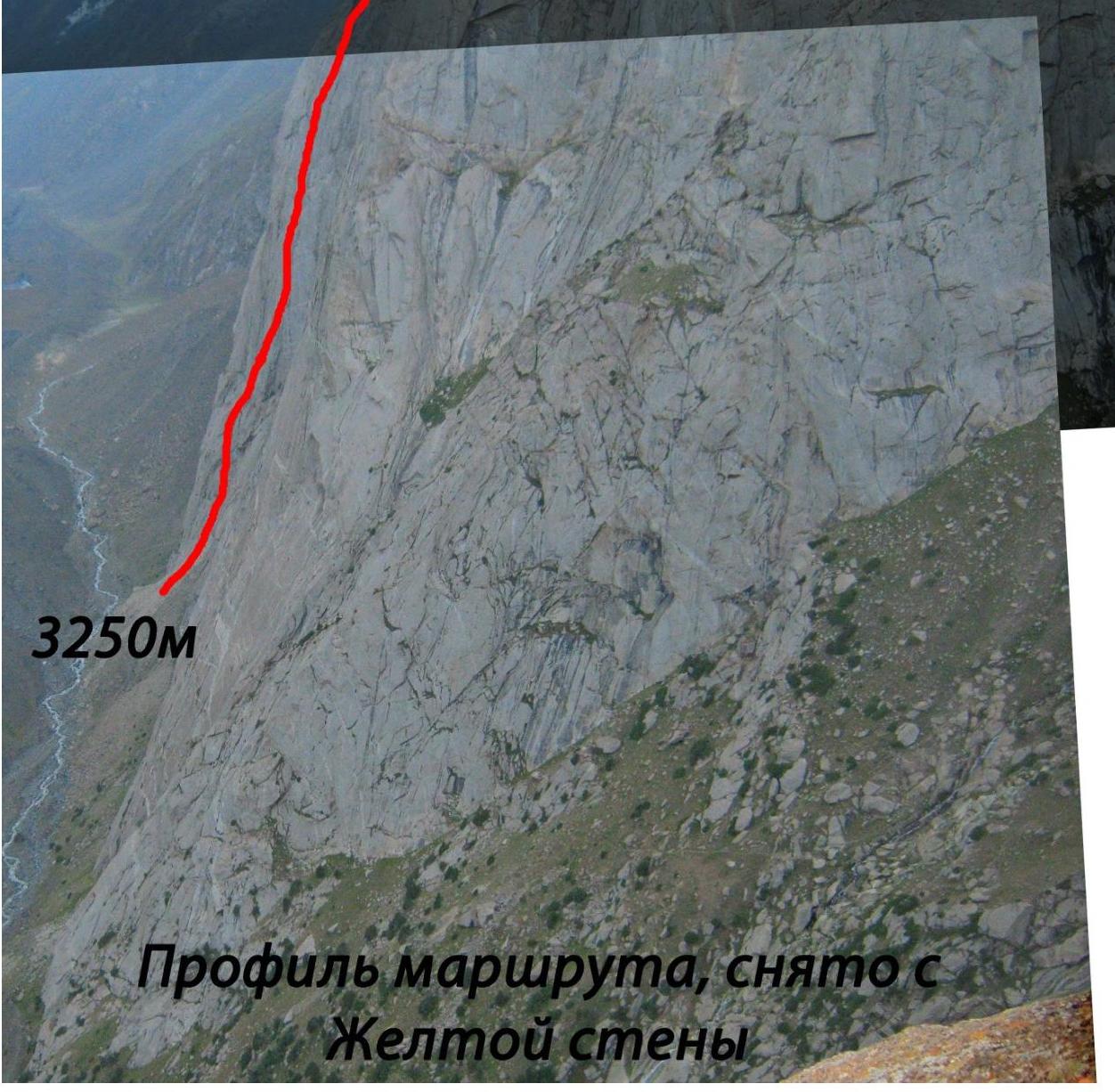
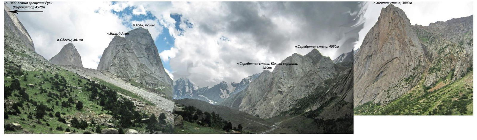
Photo panorama of the area
Team's Tactical Actions
In July 2014, the Russian Championship in mountaineering in the technical class took place in the Karavshin valley. After the championship, some teams had a few free days left.
Thus, Anastasia Yermishina from the Tomsk-Krasnoyarsk team and Alexander Zhigalov from the Krasnoyarsk-2 team joined forces to make two first ascents:
- On Silver Wall
- On Yellow Wall
On August 11, 2014, they left the base camp, and by 9:00 were under the Yellow Wall. They approached the Silver Wall at 10:30. It was decided to choose a simple, logical, and direct route for the first ascent to descend before nightfall.
They walked along the Silver Wall, paying attention to the right part — there was a lot of diverse terrain, and in the middle part, the angle of inclination increased.
Then they reached a deep watershed (gully) between the Silver Wall main peak and the South Summit. From this point, Ivan Temerev's 5A category route begins, via the SE wall chimneys, 2011. They immediately noticed a pronounced buttress starting slightly above the foot of the gully and leading to the South Summit of Silver Wall, for which, according to available information, there were no mountaineering routes.
They started the route at 10:50, 100 m to the left and below the start of the gully, on simple rocks with a third category of difficulty.
At the beginning of the route:
- they built a small cairn from stones.
The route features:
- several sections of 10–20 m with 5th category of difficulty
Overall, the route is:
- straightforward
- passes through simple rocks of 3–4 category of difficulty
- difficult sections are bypassed on simpler terrain.
There are many ledges, including large ones suitable for overnight stays. Almost all stations are on ledges. There are also many grassy tussocks and vegetation. This should be taken into account when attempting the ascent in bad weather or after heavy rainfall.
The terrain is diverse. In the lower part, anchor pitons were used, while in the upper part, camalots BD from #0.25 to 4 were mostly used for protection and stations. All stations were set up on their own points and with the help of using the terrain.
No equipment was left on the route. The team reached the summit at 17:20. Not finding a note or a control cairn on the summit, they decided to assume that this was the first ascent of this summit.
On the summit, they:
- built a cairn from stones
- wrote a note
- wrapped the note in a polyethylene bag
- placed it in a capsule from "Supradin"
- left it on the summit
They began their descent at 18:45. Initially, it was assumed that the South Summit was part of the same massif as the Silver Wall main peak, but upon reaching the summit, it turned out that it was a separate peak, separated by deep "circuses" from the neighboring ridges and having a narrow ridge descending towards the scree, in the direction of the gully. They decided to descend via the gully between the Silver Wall main peak and the South Summit.
This turned out to be a convenient descent route, presumably 2B category of difficulty. There are two rappelling sections:
- First — 15 m
- Second — 55 m
The rest is done by free soloing downwards.
They were back in camp by 21:30. Throughout the entire route, they used a simultaneous movement scheme.
| № | ||||||||||||||||||||||
|---|---|---|---|---|---|---|---|---|---|---|---|---|---|---|---|---|---|---|---|---|---|---|
| 12 | ||||||||||||||||||||||
| 11 | ||||||||||||||||||||||
| 10 | ||||||||||||||||||||||
| 9 | ||||||||||||||||||||||
| 8 | ||||||||||||||||||||||
| 7 | ||||||||||||||||||||||
| 6 | ||||||||||||||||||||||
| 5 | ||||||||||||||||||||||
| 4 | ||||||||||||||||||||||
| 3 | ||||||||||||||||||||||
| 2 | ||||||||||||||||||||||
| 1 | ||||||||||||||||||||||
| 0 | ||||||||||||||||||||||
| № |  |  | R25 | |||||||||||||||||||
| --- | --- | --- | --- | |||||||||||||||||||
| 1 | R24 | |||||||||||||||||||||
| 2 | R23 | |||||||||||||||||||||
| 3 | R22 | |||||||||||||||||||||
| 4 | R21 | |||||||||||||||||||||
| 5 | R20 | |||||||||||||||||||||
| 6 | R19 | |||||||||||||||||||||
| 7 | R18 | |||||||||||||||||||||
| 8 | R17 | |||||||||||||||||||||
| 9 | R16 | |||||||||||||||||||||
| 10 | R15 | |||||||||||||||||||||
| 11 | R14 | |||||||||||||||||||||
| 12 | R13 | |||||||||||||||||||||
| 13 | R12 |
III+, 15 м, 55° III, 30 м, 40° III, 35 м, 45° III, 30 м, 45° IV–, 30 м, 50° V–, 10 м, 65° IV, 30 м, 55° III, 30 м, 45° IV+, 35 м, 60° IV+, 40 м, 52° IV, 30 м, 50° IV, 35 м, 55° III+, 30 м, 50°
Section R0–R1: start of the route to the left and below the gully — watershed between Silver Wall main peak and South Summit, 100 m away. A small cairn is built from stones. Simple rock climbing through grassy ledges. Station on a ledge.
Section R1–R3: series of ledges and internal corners with a rightward inclination. Easy climbing. Exit to a large ledge. Landmark:
- to the right, the lower part of the gully
- a large chimney with a plug
- Temerev's route, 5A, 2011, goes there
Section R3–R4–R5–R6: leftwards along a gentle wall with tussocks to an internal corner. Alternating "ram's foreheads" and grass tussocks along the corner. Exit to a large ledge, continuing leftwards across the entire wall.
Section R6–R7–R8: from the right part of the ledge upwards onto the wall, then traverse rightwards for 8 m, exit to the buttress. Upwards through internal corners via ledges to a wall with slits. Much terrain, reliable protection points. Further through a widening chimney, exit to a ledge, the summit of the first bastion.
Section R8–R9: a crack from left to right, through a ledge into an internal corner, with two equally viable options:
- up the corner,
- or rightwards along the wall with slits, exit to a ledge.
Section R9–R10: several inclined internal corners parallel to each other, then a crack, exit to a ledge.
Section R10–R11: free climbing along a ridge, then an internal corner with grass. Exit to a ledge under a "sentinel".
Section R11–R12: along the ledge rightwards and upwards, deviating rightwards from the buttress to simpler terrain.
Section R12–R14: series of internal corners with grassy tussocks, many ledges. Various options for passage are possible here.
Section R14–R15: steep internal corner, 10 m, then exit to a sloping wall with many cracks and slits leading rightwards. Landmark:
- to the left — a large inclined chimney, a watershed.
Section R15–R17: key section of the entire route. Along a wall with crevices under a cornice, bypass the cornice on the right, into an internal corner, then through a chimney — exit to a ledge.
Section R17–R18: alternating inclined walls, passage through a large ledge, suitable for overnight stay.
Section R18–R19:
- a wall with a slit, done by free climbing.
- exit to the ridge of the right buttress.
- to the right, a view opens up to the descent gully.
- station on the left edge of the ledge.
Section R19–R20: steep wall with slits, 10 m, then upwards and rightwards through internal corners.
Section R20–R21: alternating walls and ledges, easy climbing, exit to a ledge on the ridge. A view opens up to the summit.
Section R21–R25: through a small wall, exit to the ridge, then on foot along ledges and sloping walls, exit under a black wall. Along the wall by free climbing, 15 m, exit to the summit.
Descent via the descent gully.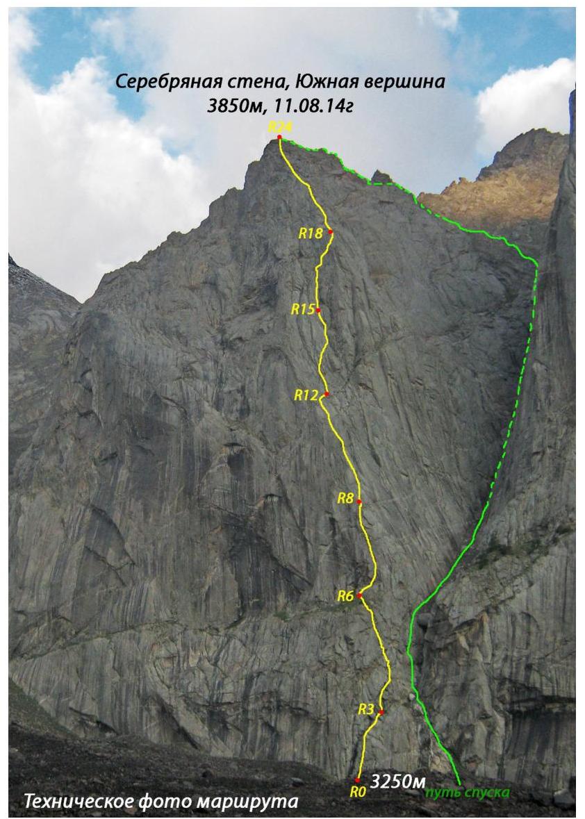
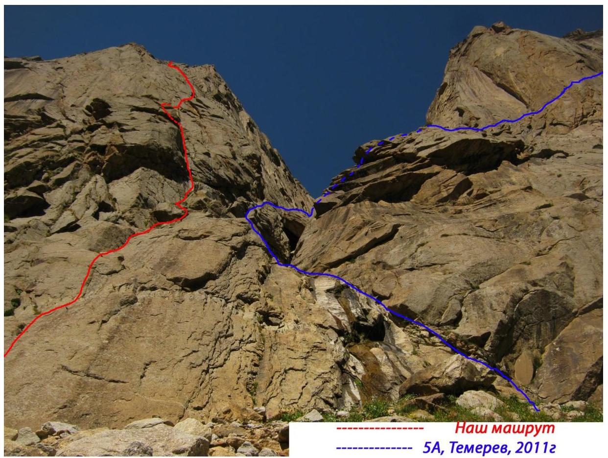
- 5А, Temerev, 2011