Passport
-
Class: Technical ascents.
-
Climbing area: Pamir-Alay, Turkestan Range.
-
Object of ascent: Peak 4810 m, Northeast wall.
-
Difficulty category: 6B
-
Route characteristics:
Height difference: –1050 m. Route length: –1443 m. Length of sections:
- 6th cat. diff. – 708 m.
- 5th cat. diff. – 375 m.
Average steepness of the main part of the route – 78°.
-
Pitons driven – 88/39 Chocks – 195/54 Bolts – 72/62
-
Climbing hours: –160 days: processing – 9, on the route – 8.
-
Overnights: in a platform tent – 8 on a ledge – 1
-
Participants of the ascent:
POGORELOV Aleksandr Grigorievich – Master of Sports of International Class POLOKHOV Vitaly Andreevich – Master of Sports
-
Team coach: POGORELOV Aleksandr Grigorievich.
-
Route processing: – August 4–12, 1999. Departure on the route: – August 14, 1999, after 15:00. Summit: – August 22, 1999. Return to base: – August 23, 1999.
-
Organization: Rostov Regional Federation of Mountaineering and Rock Climbing.
Photo #1. General photo of peak 4810 m.
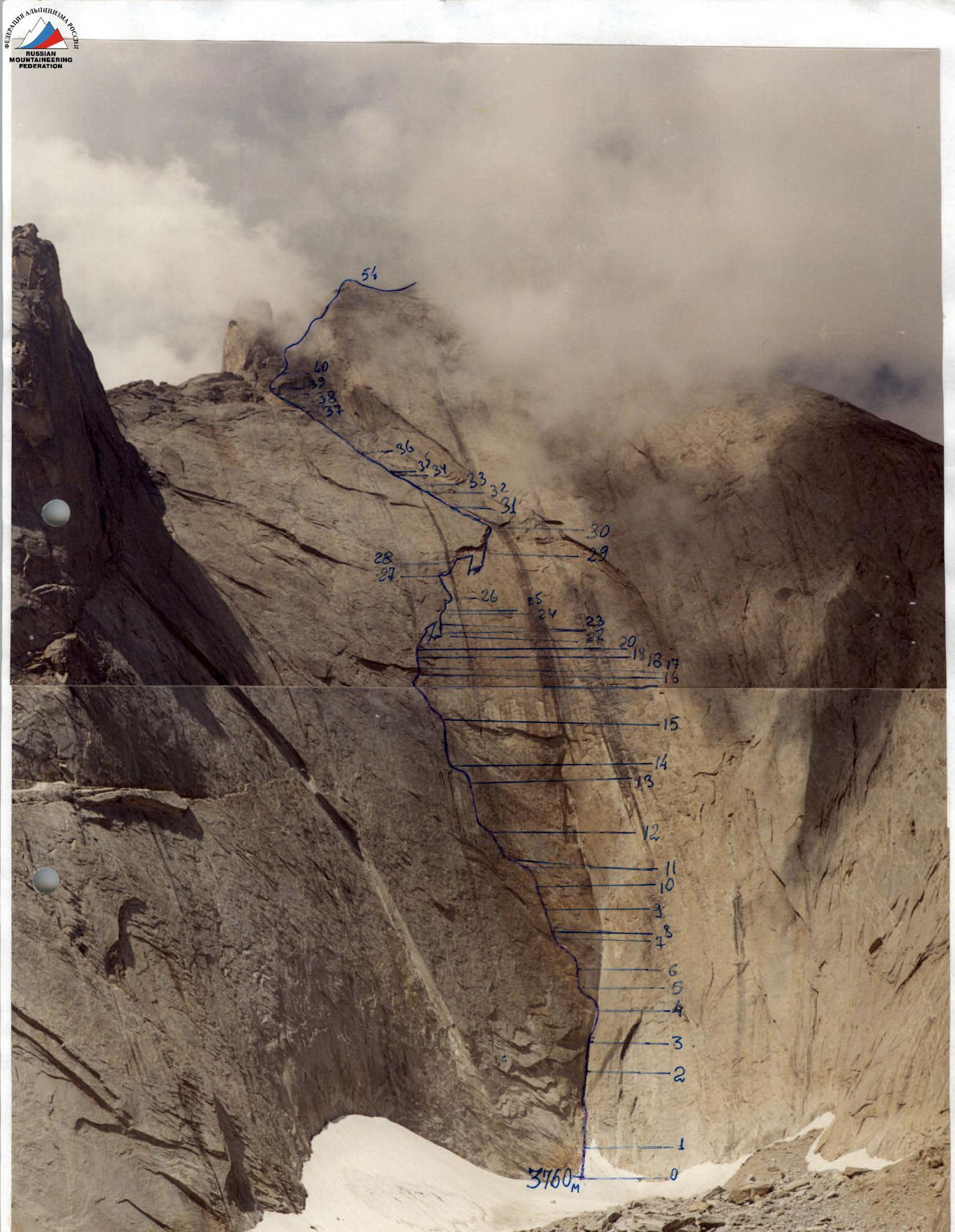
Photo #3. Technical photo of the route. ROUTE SCHEME IN UIAA SYMBOLS
| Rock | Chocks | Bolts | Notes/R-numbers | Difficulty category | Length of section in m | Steepness in degrees | Section # |
|---|---|---|---|---|---|---|---|
| 5/2 | 8/4 | 3/2 | R12 | Y1⁺ A2 | 40 | 90 | 14–15 |
| Water flow | |||||||
| 3/3 | 3/3 | 1/1 | Y1⁺ A2 | 20 | 90 | 13–14 | |
| 4/2 | 10/4 | 1/1 | R10 | Y1⁺ A2 | 40 | 90 | 12–13 |
| R9 | |||||||
| 2/2 | 5/5 | Y1⁺ A3 | 30 | 90 | 11–12 | ||
| 6/5 | 7/4 | 4/4+ 2* | "arrow" *—for platform R8 Water flow | Y1⁺ A2 | 30 | 90 | 10–11 |
| R7 | Y1⁺ A3 | 27 | 91 | 9–10 | |||
| 4/3 | 4/3 | 5/5 | Y1⁺ A3 | 25 | 91 | 8–9 | |
| 4/4 | 3/3 | 2/2 | R6 | Y1⁺ A3 | 7 | 92 | 7–8 |
| 2/2 | 1/1 | 1/1 | Y1⁺ A2 | 30 | 92 | 6–7 | |
| 10/10 | R5 | Y1⁺ A2 | 15 | 90 | 5–6 | ||
| 2/2 | 5/4 | 2/2 | Y1⁺ A4 | 25 | 95 | 4–5 | |
| 9/9 | R3 | Y1⁺ | 30 | 80 | 3–4 | ||
| 4 | 2 | 1 | R2 | Y1⁺ | 25 | 80 | 2–3 |
| 2 | 4 | R1 | Y | 60 | 70 | 1–2 | |
| R0 | |||||||
| 2 | 6 | R0 | Y | 50 | 50 | 0–1 | |
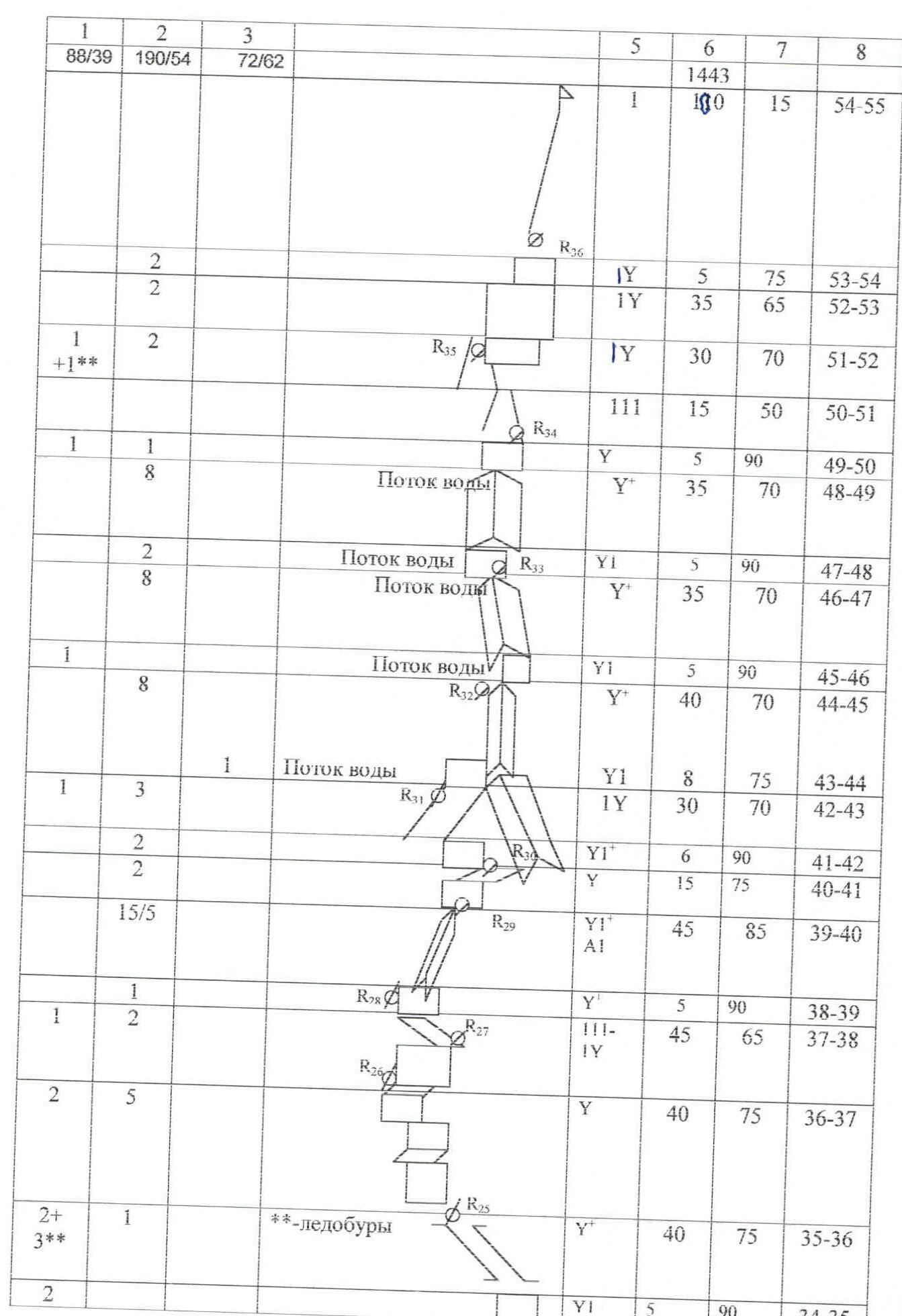
| 2 | 2 | R24 | Y | 30 | 70 | 33–34 | |
| 2 | 2 | R23 | Y⁺ | 20 | 75 | 32–33 | |
| 4 | 1Y | 45 | 65 | 31–32 | |||
| 8 | R22 | Y⁺ | 50 | 75 | 30–31 | ||
| 3/2 | 8/5 | 2/2 | R21 Left "brow" | Y1⁺ A2 | 35 | 90 | 29–30 |
| 5 | 95 | ||||||
| 2/1 | 8 | 2/2 +2* | *—for platform R20 | Y1⁺ A1 | 40 | 90 | 28–29 |
| 1/1 | 3/3 | 1/1 | R19 Water flow | Y1⁺ A2 | 10 | 91 | 27–28 |
| 2 | 9/1 | R18 | Y1⁺ A2 | 35 | 90 | 26–27 | |
| 1 | R17 | Y1⁺ | 5 | 85 | 25–26 | ||
| 1 | 1/1 | Y1⁺ | 5 | 92 | 24–25 | ||
| 6/2 | 8/2 | R16 | Y1⁺ A1 | 40 | 90 | 23–24 | |
| 6/6 | R15 | Y1⁺ A1 | 25 | 90 | 22–23 | ||
| 2/1 | Y1⁺ | 5 | 85 | 21–22 | |||
| 1/1 | 3/3 | 3/3 | R14 3rd cornice | Y1⁺ A1 | 20 | 1 | 20–21 |
| 2/2 | 5/5 | Water flow 2nd cornice | Y1⁺ A1 | 10 | 85 | 19–20 | |
| 3/2 | R14 | Y1⁺ A1 | 8 | 90 | 18–19 | ||
| 1/1 | 1/1 | 1st cornice | Y1⁺ A4 | 2 | 135 | 17–18 | |
| 4/4 | 2/2 | 1/1 +2* | R13 | Y1⁺ A4 | 20 | 90 | 16–17 |
| 4 | 8 | QR13 | Y1⁺ | 35 | 85 | 15–16 | |
| 1443 | |||||||
| 1 | 180 | 15 | 54–55 | ||||
| R35 | Y | 5 | 75 | 53–54 | |||
| 2 | 2 | 1Y | 35 | 65 | 52–53 | ||
| 1+1** | 2 | R35 | Y | 30 | 70 | 51–52 | |
| 111 | 15 | 50 | 50–51 | ||||
| 1 | 1 | R34 | Y | 5 | 90 | 49–50 | |
| 8 | Water flow | Y⁺ | 35 | 70 | 48–49 | ||
| 2 | R33 Water flow | Y1 | 5 | 90 | 47–48 | ||
| 8 | Water flow | Y⁺ | 35 | 70 | 46–47 | ||
| 1 | R32 Water flow | Y1 | 5 | 90 | 45–46 | ||
| 8 | Y⁺ | 40 | 70 | 44–45 | |||
| 1 | R31 Water flow | Y1 | 8 | 75 | 43–44 | ||
| 1 | 3 | 1Y | 30 | 70 | 42–43 | ||
| 2 | 2 | R30 | Y1 | 6 | 90 | 41–42 | |
| Y | 15 | 75 | 40–41 | ||||
| 15/5 | R29 | Y1 A1 | 45 | 85 | 39–40 | ||
| 1 | R28 | Y | 5 | 90 | 38–39 | ||
| 1 | 2 | R27 | 111–Y | 45 | 65 | 37–38 | |
| 2 | 5 | R26 | Y | 40 | 75 | 36–37 | |
| 2+ 3** | 1 | R25 **—ice screws | Y² | 40 | 75 | 35–36 | |
| 2 | Y1 | 5 | 90 | 34–35 |
Route description by sections
R0–R1 — Steep snow slope. R1–R2 — Entrance into a huge internal corner formed by two walls, closing approximately 350 meters further with a huge cornice. In the first half, these walls form this corner at about 90°. Free climbing. Large chocks. Pitons, boxes. R2–R3 — Internal corner with smooth slabs. Difficult climbing. Small and medium chocks and friends. R3–R4 — Internal corner is steep and heavily destroyed, so further climbing 30 m to the right of the corner. On the left, there are overhanging rocks. At the end of the section, return to the internal corner again. Careful climbing as the corner is destroyed. Insurance through pitons and medium chocks. R4–R5 — Overhanging, with a destroyed crust, completely without cracks, rocks. Here is the exit to the Northeast wall from the huge overhanging internal corner. Climbing on ITO, "sky-hooks" (holes). Bolts — 8 mm, every 2–3 m. Climbing diagonally: from right to left with a gain in height. R5–R6 — A ledge or a flap forming a small internal corner. You can drive in 1–2 pitons. However, it is dangerous to do this in the upper part as it can be destroyed. From it, a transition along a monolithic overhanging slab to the second ledge, forming an expanding gap formed by a huge "flap". In the upper part, it overhangs and rests against a small cornice. In the transition from the first flap to the second – ITO, holes, "sky-hooks". The second large ledge is passed partly by climbing, partly by ITO. Large friends. R6–R7 — Passage of overhanging monolithic slabs, without relief and cracks. Climbing diagonally upwards from right to left towards the cornice. ITO. R7–R8 — Along the overhanging internal corner to its middle. Climbing on ITO. In the middle part, overcoming the overhang and exit to a monolithic slab. R8–R10 — Passage of overhanging monolithic slabs, without relief and cracks. Climbing diagonally upwards from right to left towards the ledge (looks like an "arrow" from below). ITO. At the end of the section, under a small cornice, a platform tent was suspended. R10–R11 — Traversing from right to left to the ledge. Strenuous climbing. It overhangs and therefore repels. Chocks, friends, pitons. It is necessary to pass before 13:00 as a water flow starts after this time. R11–R12 — Overcoming a small overhang formed by a flap, and along a monolithic slab left-upwards towards a large crack. ITO. R12–R13 — Along a sheer crack straight up. Partly climbing, partly ITO. Medium and large friends and chocks. R13–R14 — Sheer monolithic slab with a small cornice from a ledge. ITO. R14–R15 — Wide crack upwards, forming a chimney. Filled with ice. After 13:00, water flows. In the middle part, it rests against an overhanging thin ledge. After the overhang, there is another crack again. Difficult and tense climbing. Partly ITO. Large friends and chocks. R15–R16 — Pendulum to the left-down to a small ledge. From here, climbing from right to left along the ledge – 40 m. Insurance through medium and large friends, chocks, and pitons-boxes. R16–R17 — Monolithic slab leading to a cornice. The cornice is passed in its middle part. This is the first cornice. Behind it, about 15 m to the right, there is a second cornice, and another 10 m further – a third. All of them are bypassed on the left. R17–R18 — Large cornice. Passed on ITO. There is one crack for a box; during the passage, two bolted pitons were also driven and used. R18–R19 — Monolithic slab without relief and cracks. Bolted pitons, holes for "sky-hooks". Movement to the right upwards towards a water flow with cracks and small ledges. R19–R20 — A series of cracks and small ledges. After 11:00 – water flow. R20–R21 — Return to the left on a monolithic slab as the cracks along the flow end. Crossing the water flow through a small cornice formed by ledges. Small chocks and thin pitons. ITO using "sky-hooks". R21–R22 — Along the monolithic slab, a small pendulum to the right exits into a monolithic internal corner. Along it, climbing several meters up, approaching a 25-meter monolithic slab made of solid granite, called by us the "memorial slab". R22–R23 — Along the slab, a transition from left to right to two crevices. Completely ITO. At the end of the section, a pendulum. R23–R24 — Along the crevice straight up. Mainly climbing. Partly ITO. Small and medium chocks, pitons. R24–R25 — Overhanging thin ledge. Used camalot #5 and a bolt. Difficult climbing. R25–R26 — Ledge. Passed by free climbing. R26–R27 — Implicit internal corner with the presence of cracks and small ledges. Passed by free climbing. R27–R28 — Crossing the water flow. Initially using cracks in the overhang, and then small ledges on the flow. Passed in the second half of the day when water was flowing. R28–R29 — Passage of the "brow". Initially along the internal corner, then to the left along the ledges. The ledges are not monolithic. To drive in a bolt, it was necessary to search for a monolithic section for a long time, chipping off the crust. Further, a 15-meter pendulum into a ledge leading to the cornice of the right part of the "brow". Passed by free climbing. R29–R30 — Through the cornice, a transition into the internal corner. The internal corner also overhangs. The cornice and internal corner are filled with water. Medium and large friends and chocks. R30–R31 — Huge chimney with ice in the left corner. Free climbing. For insurance, medium and large friends were used. R31–R32 — Destroyed wide chimney. R32–R33 — Smooth wall leading into a wide chimney filled with ice. R33–R34 — Wide chimney filled with ice. R34–R35 — Overhanging wet wall leading into the second wide chimney with ice. R35–R36 — Wide chimney with ice. Passed using ice screws and crampons. Insurance through ice screws. R36–R37 — A series of walls with dissected relief. Free climbing. Insurance through medium and large friends, chocks, and pitons. R37–R38 — Bypassing the wall on the right, exit along a ledge under a rock bastion. R38–R39 — Rock wall leading under an internal corner. R39–R40 — Internal corner with smooth monolithic walls. Passed partly by free climbing, partly on ITO. R40–R41 — Rock wall leading into a wide internal corner along which water flows. R41–R42 — Overhanging rock wall with a crevice in the middle. R42–R43 — Steep, destroyed ledge. R43–R44 — Monolithic, smooth wall filled with water. Before passing, a bolt was driven for insurance. Passed by free climbing. Climbing is psychologically tense. R44–R45 — Wide internal corner with water flowing along the right side. R45–R46 — Monolithic, smooth wall with a water flow. R46–R47 — Wide internal corner with smooth monolithic sides. The left side is sheer; water flows along the right. Tense free climbing. For insurance – medium friends. R47–R48 — Sheer wall. To the right of it, there is a corner along which water flows. R48–R49 — Wide internal corner with water flowing along it. Rocks are monolithic and smooth. R49–R50 — Sheer wall leading into a wide snow-ice couloir. R50–R51 — Wide ice-snow couloir. R51–R52 — Steep ice-snow couloir. Passed in crampons with an ice axe. R52–R53 — Rock blocks before exiting onto the ridge. R53–R54 — Wall leading onto the ridge. R54–R55 — Simple rock ridge leading to the summit.
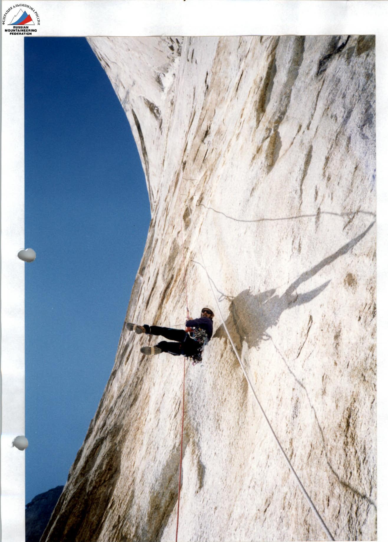
Photo #3. Passing the rope on section R4–R5.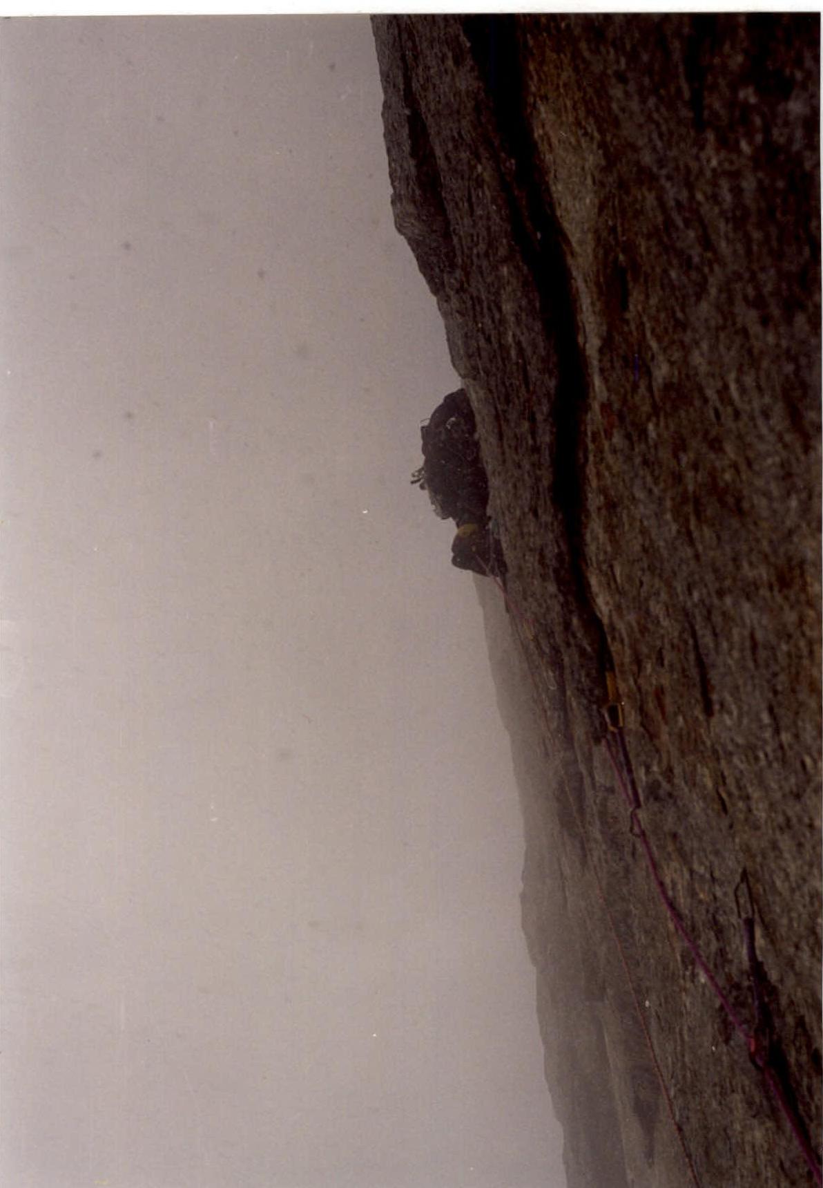
Photo #4. In the second half of the day, it rained or wet snow. Passing section R6–R7.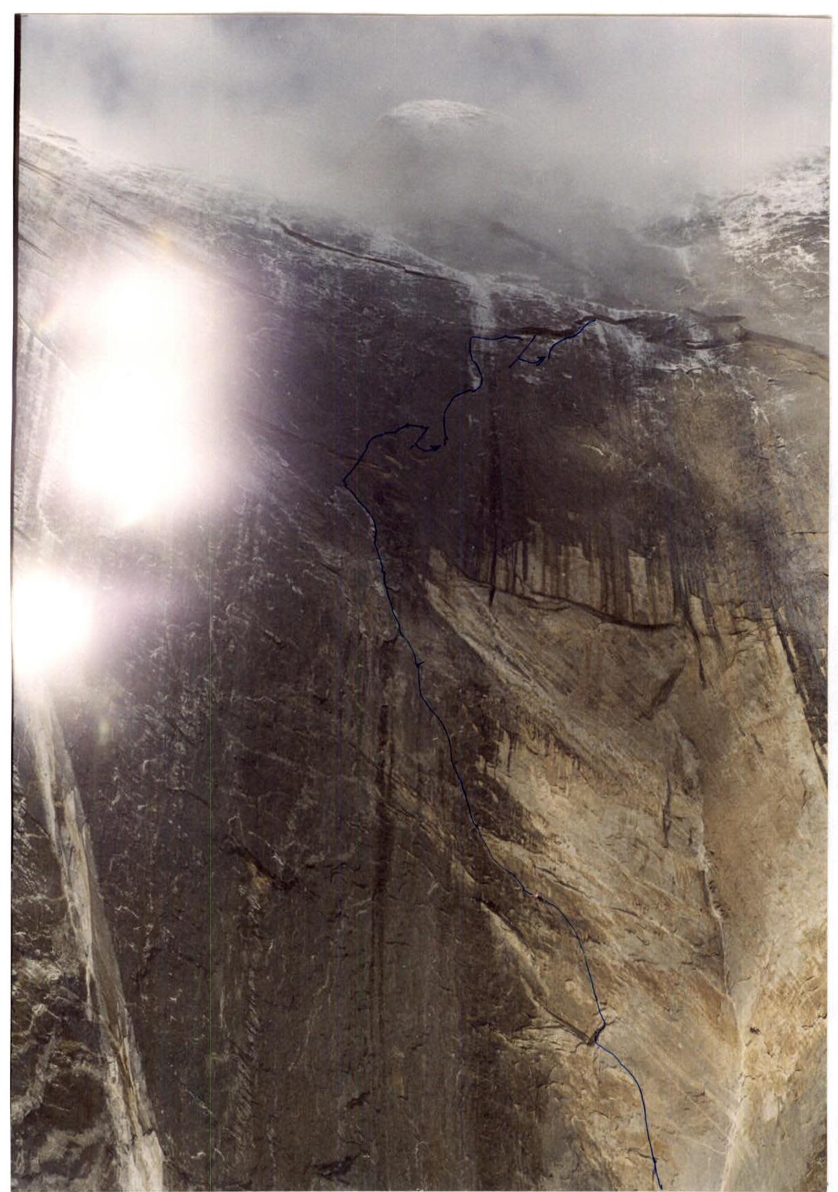
Photo #5. The wall after bad weather.
Tactical actions of the team
The team's tactics were based on:
- Technical features of the route;
- Problems that were anticipated and arose during the ascent;
- Team capabilities.
At the initial stage of the ascent, during route processing, the team worked in the following composition:
- A. POGORELOV — team leader;
- V. POLOKHOV;
- A. POPOV — Candidate for Master of Sports;
- A. ZAVGorodny — Candidate for Master of Sports.
On August 12–13, there was a strong bad weather, after which A. POPOV and A. ZAVGorodny refused to continue the ascent. Due to the сложившейся situation, the ascent was continued by a pair.
The main part of the chosen route represents an alternation of overhanging and sheer monolithic rocks. The overhangs protected us from falling rocks and ice.
All overnight stays on the wall were organized under cornices. Of these:
- 8 overnights in a platform tent;
- 1 overnight on a ledge under a cornice (semi-reclining).
The route created considerable difficulties due to the fact that the route thread went diagonally. The presence of a processed route and ropes (although diagonal) was necessary in case of emergency evacuation. Otherwise, to organize a descent, it was necessary to create descent stations by driving in bolted pitons on the sheer sections.
On sections R4–R8, we encountered the problem of metamorphic crust. We had to chip it off, and since it was on an overhang, debris and dust flew into our eyes, and to protect them, we had to work in goggles.
The high technical complexity of the wall was compensated by the possibility of processing the route. This allowed us to bring in the necessary equipment and water during processing, which is absent on the wall, despite the abundance of snow and rain this year.
Passage of route sections by days:
| Date | Passed route sections | Date | Passed route sections |
|---|---|---|---|
| August 4 | R0 — to the middle of section R4–R5 | August 14 | Ascent to the platform (R10–R11) |
| August 5 | To the end of section R5–R6 | August 15 | To the end of section R17–R18 |
| August 6 | To the middle of section R6–R7 | August 16 | To the end of section R21–R22 |
| August 7 | To the end of section R7–R8 | August 17 | To the end of section R22–R23 |
| August 8 | To the middle of section R9–R10 | August 18 | To the end of section R26–R27 |
| August 9 | To the middle of section R10–R11 | August 19 | To the end of section R27–R28 |
| August 10 | To the end of section R11–R12 | August 20 | To the end of section R28–R29 |
| August 11 | To the middle of section R13–R14 | August 21 | To the middle of section R37–R38 |
| August 12 | To the end of section R14–R15 | August 22 | Summit |
| August 13 | Bad weather, snowfall | August 23 | Descent to Ak-Su valley |
The upper part of the route, starting from section R35–R36, was previously passed by a pair of climbers from St. Petersburg, who were ascending via the Odintsov route.