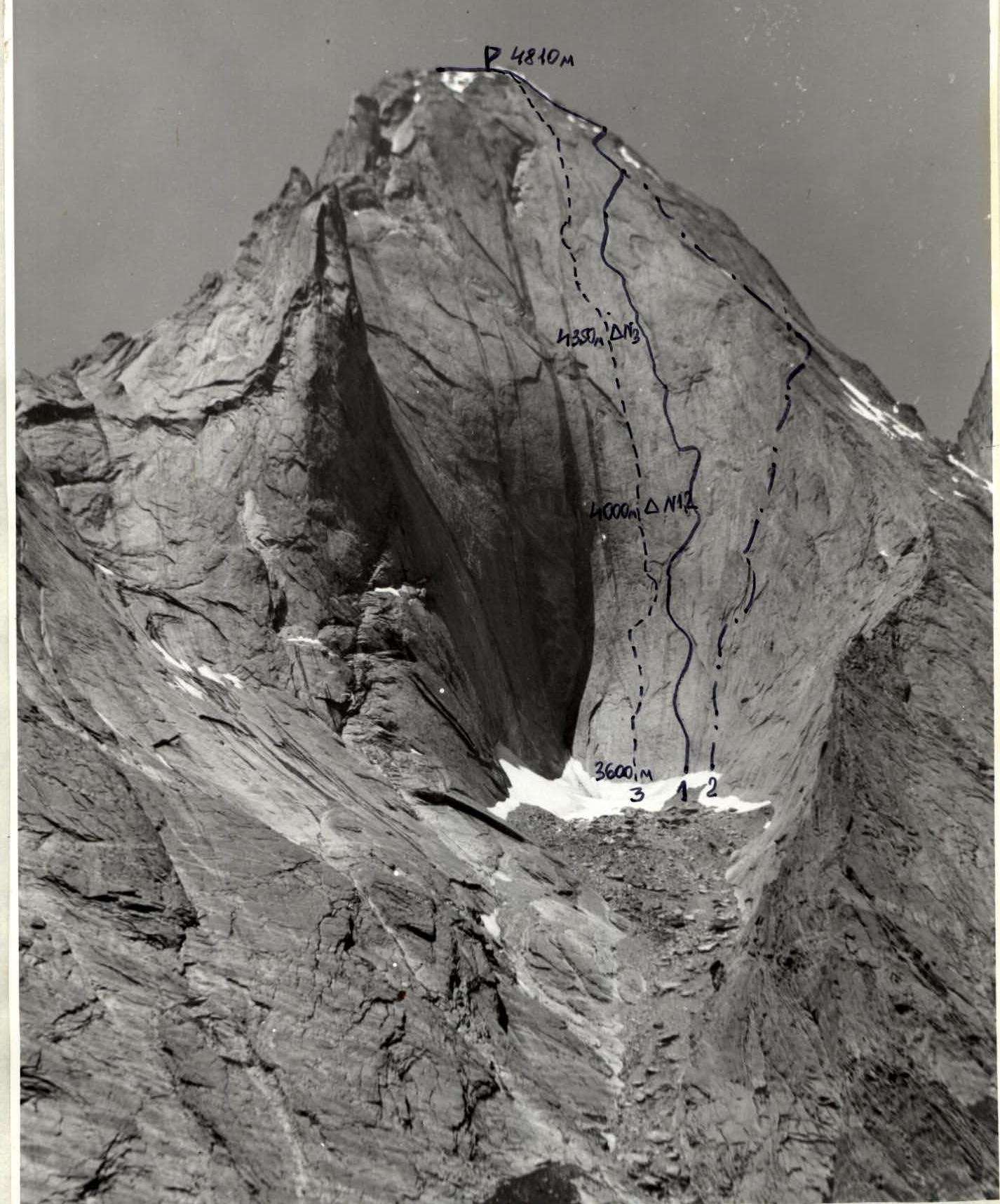
GENERAL VIEW OF THE SUMMIT. July 1993, "Lubitel-166" camera, distance 1.5 km, height 3200 m. 1 — Sitnik's route; 2 — Vedernikov's route; 3 — team's route.
Team's Tactical Actions
The team's tactics were determined by the extensive experience of climbing in this area, as well as experience participating in Alpine Championships.
Preliminary reconnaissance and observation of the proposed route were organized, an approximate ascent corridor was identified, and a tactical plan was drawn up. The team's movement along the route was carried out in accordance with the tactical plan, which was fully implemented. The route was completed in 6 days:
- Days 1-2 — the lower part of the wall was processed (up to section #13). For greater efficiency, the work was carried out in triples;
- Day 3 — the team in full strength started on the route. They covered about 4 ropes above the processed sections, approximately 15 m from the line of movement, there was a flake in the form of a "fig" with a 1 m wide shelf. Having crossed it with a pendulum, a bivouac was organized there. Due to the fact that there were no more shelves for overnight stays ahead, it was decided to spend the night at this location twice, processing the route;
- Day 4 — sections #14-16 were processed;
- Day 5 — having passed the processed ropes and continuing to move vertically upwards, they reached a narrow sloping shelf, on which the last overnight stay was organized before the summit. On the same day, sections #24-28 were processed;
- Day 6 — the team reached the summit, having passed the "roof" with the maximum speed for climbs of such complexity. Along with the processed sections, they covered about 15 ropes.
Throughout the ascent, a constant, sequential change of leading rope teams was carried out — once during the entire day. The correctly chosen bivouac locations and the tactic of changing leaders allowed the team to move without reducing speed and preserving their strength. The extremely difficult route was completed with virtually no deviations from the planned route and at a high speed.
The route took 67 hours to complete. The safety of the ascent was ensured by the correct choice of route, working only on a double rope, using a wide range of modern mountaineering equipment, including:
- sky hooks,
- hook-feet,
- removable bolt hanger hooks Ф В and Ф 6 mm, etc.,
- a large amount of self-made equipment.
Bivouacs were organized in safe locations. The team had:
- a set of emergency medical supplies,
- hammocks for separate overnight stays,
- hot food, prepared twice a day,
- pocket rations,
- a sufficient supply of water.
The team was under constant observation, and there was regular communication via a "Lastochka" type radio station.
During the ascent, a rescue team with the right to exit up to category 6B was stationed at the base camp.
During the ascent, all waste:
- was burned
- or taken away.
Almost all hooks:
- were hammered out
- bolt hangers — were unscrewed.
The route was left clean.
There were no accidents or injuries.
Description of the Route by Sections
The route to peak 4810 via the center of the East face.
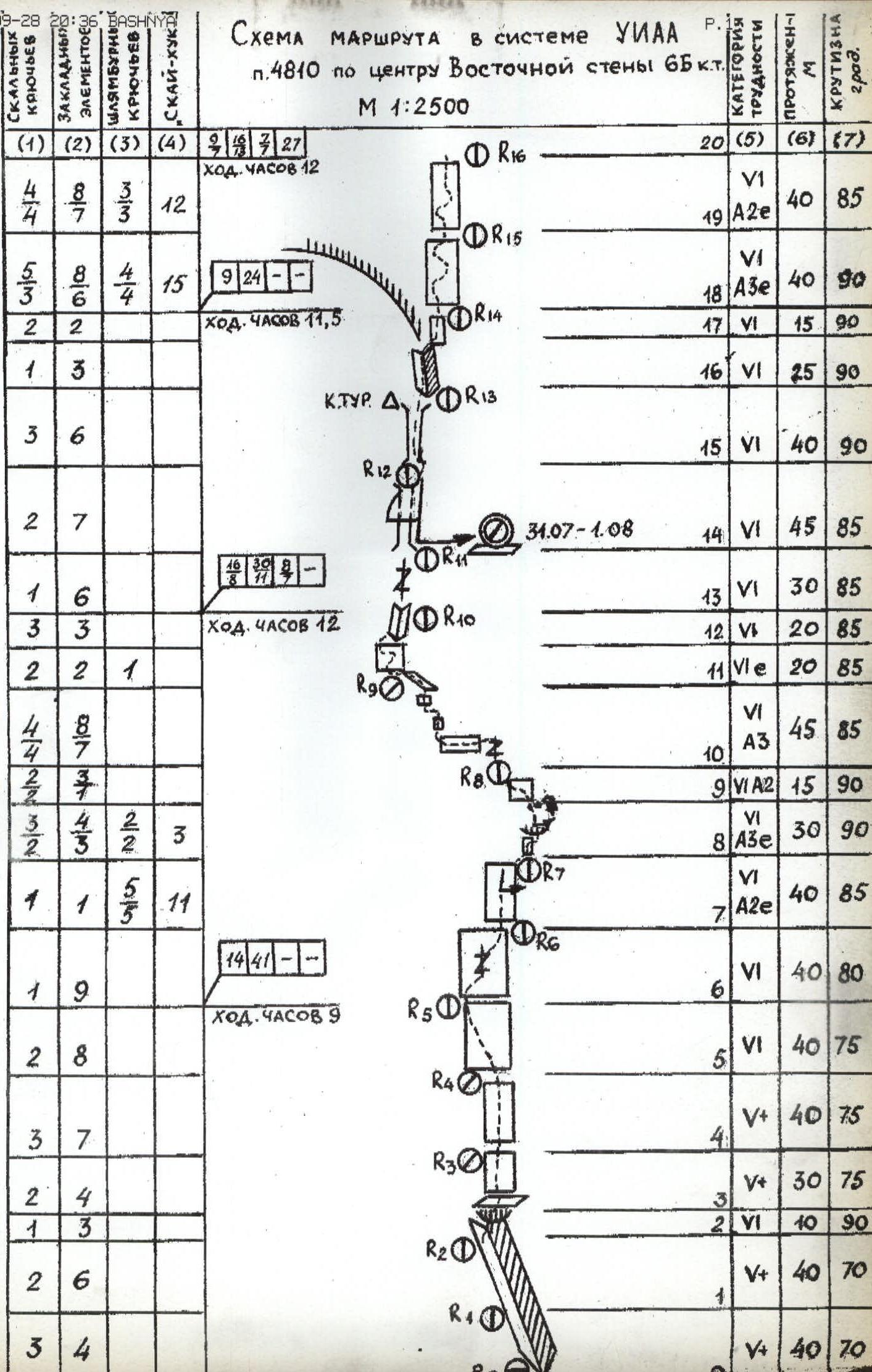
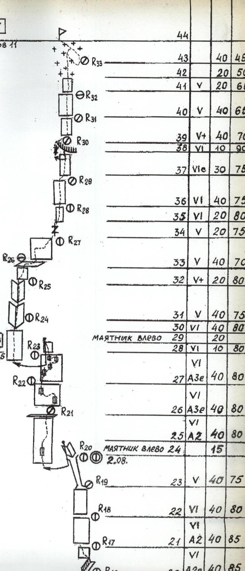
R0-R2: The start of the route is to the left of the characteristic flake, going left and upwards. R2-R3: Exit through an overhang to the right onto a shelf. R3-R6: Free climbing on slabs. R6-R8: Movement on a monolithic slab to the right and upwards using bolt hangers and sky hooks. R8-R9: Through a cornice to the right and upwards to AID on poor flakes to a diagonal shelf. R9-R10: Pendulum to the left, then upwards on AID on poor flakes to a diagonal shelf. R11-R12: Monolithic slab, passable by free climbing, protection through bolt hangers. R12-R17: Internal angle turning into a crack — chimney, extremely difficult climbing. R17-R20: Exit from a flake that starts to go left, forming a chimney to the right onto a wall close to vertical, extremely difficult climbing using sky hooks and bolt hangers. R20-R23: On a wall that gradually becomes less steep (by degree per rope), relief appears for protection and climbing; exit into a chimney with snow formed by a flake. R23-R24: Up the chimney onto a diagonal flake, where an uncomfortable bivouac is organized. R24-R25: Difficult climbing with a slight deviation to the left to a crack. R25-R26: Up the crack first on AID, then climbing on a slab onto a small ledge with "live" rock, possible overnight stay for 1-2 people. R26-R29: On small flakes and slabs, very difficult climbing with a large amount of AID, protection on bolt hangers. R29-R30: Pendulum to the left. R30-R31: Movement on sky hooks for 10-15 m, then difficult climbing leads into an internal angle formed by a large slap. R31-R33: Up the internal angle to the top of the slap, where a semi-reclining overnight stay is possible. R33-R34: Climbing to the right and upwards to a crack. R34-R35: Up the crack, then exit onto slabs. R35-R38: On slabs under a diagonal cornice. R38-R39: Pendulum to the left, then up the crack to overcome the cornice in the upper left part. R39-R42: On gradually flattening slabs to a snow cap. R42-R44: On snow lying in a thin layer on ice to the summit, the first person moves in crampons, the rest — on fixed ropes.
Route diagram in the UIAA system: peak 4810 via the center of the East face, category 6B. Scale 1:2500.