Ascent Passport
-
Ascent class — technical
-
Ascent area — Pamir-Alay, Turkestan Ridge
-
Peak 4810 m — via the "mirror" of the 3rd wall. KTMGV 5.4.
-
Proposed complexity category — 6, first ascent
-
Height difference — 1150 m
including: wall — 885 m. Length — 1730 m. Length of sections with 5–6 difficulty category — 1320 m, including: 6th category — 1250 m (elevations 3650–4535 m). Average steepness of the wall section of the route — 74° (3650–4535 m).
-
Pitons driven:
| Rock | Nuts | Bolts |
|---|---|---|
| 123/21 | 267/29 | 23/7 |
-
Team's climbing hours — 62; 6 days + 2 days of processing
-
Overnights: 1–2 — lying in a tent and hammock-tent on platforms; 3–4 — lying in a tent on a platform and hammock-tent on the wall; 5 — lying in a tent on a platform
-
Team LOS DPhSO trade unions
-
Leader: Rusyaev Alexey Vasilievich — MS
Participants:
- Odintsov Alexander Nikolaevich — MS
- Glushko Vyacheslav Ivanovich — MS
- Dorofeev Alexey Vladimirovich — CMS
- Efimov Sergey Vadimovich — CMS
- Smirnov Viktor Valerievich — CMS
-
Team coach — MS USSR Glushko Vyacheslav Ivanovich
-
Departure to the route — July 9, 1988
Summit departure — July 16, 1988 Return — July 17, 1988

Photo — 1 Date taken — July 10, 1988, 17:00 Lens — Mir-26 Distance — 5 km Shooting height — 3800 m Shot number — 1
1 — Kritsuk's route on the Central West wall, category 6, 1988 2 — LOS DPhSO trade union team's route, climbed as part of the Leningrad Championship on peak 4810 via the "mirror" of the 3rd wall, category 6 (Rusyaev, 1988) 3 — Voronov's route on the 3rd wall, category 6, 1988
PROFILE OF THE ROUTE ON PEAK 4810 VIA THE "MIRROR" OF THE WEST WALL VIEW FROM THE RIGHT

Photo — 2 Date taken — July 18, 1988, 17:00 Lens — Lubyatel-166 Distance — 4.5 km Shooting height — 3800 m Shot number — 2
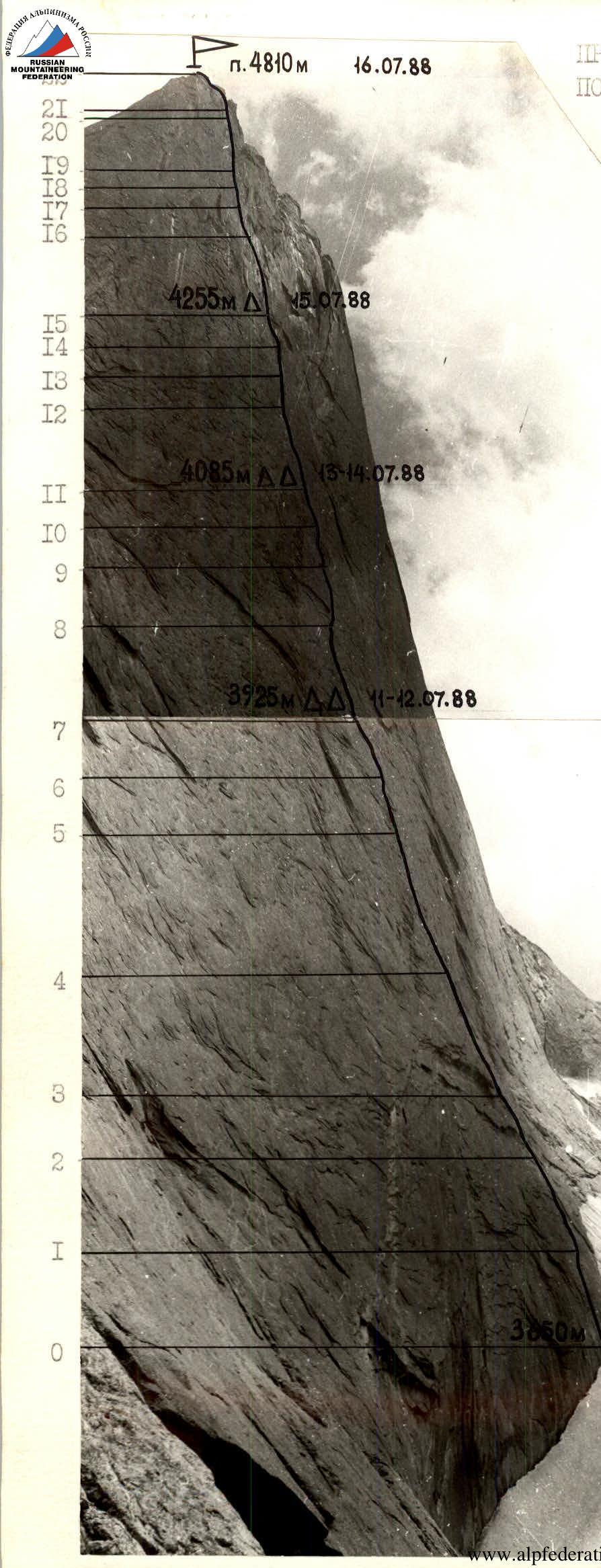
Photo — 3 Date taken — July 17, 1988 Lens — Industar-52 Distance — 1 km Shooting height — 3800 m Shot number — 3
PHOTOPANORAMA OF THE AREA
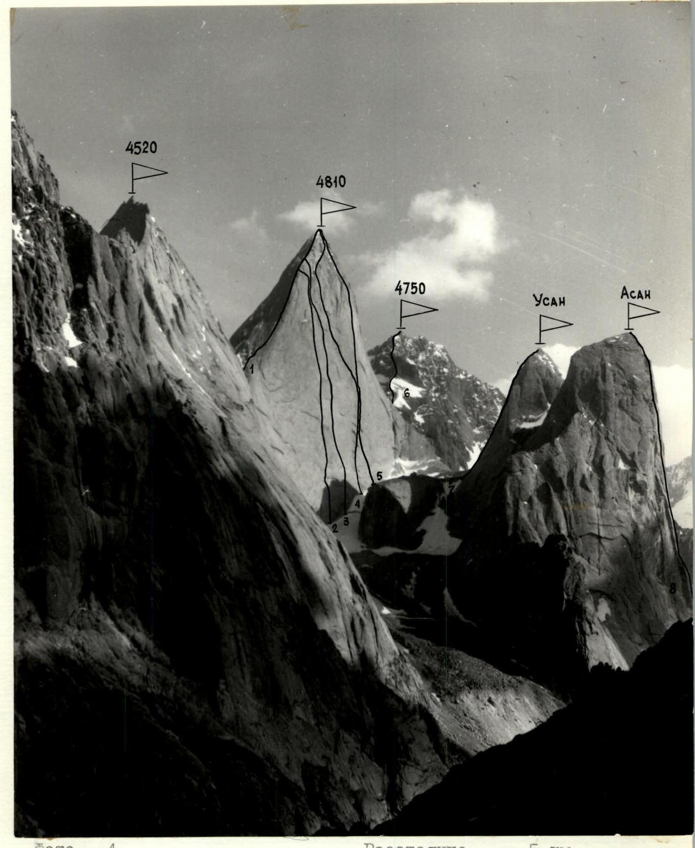
Photo — 4 Date taken — July 10, 1988, 17:00 Lens — Volna-3M Distance — 5 km, shooting height — 3800 m. Shot number — 4
1 — Sitnik's route on peak 4810 via the North ridge, category 5B, 1988 2 — Kritsuk's route on peak 4810 via the 3rd wall, category 6, 1988 3 — Rusyaev's route on peak 4810 via the "mirror" of the 3rd wall, category 6, 1988 4 — Voronov's route on peak 4810 via the 3rd wall, category 6, 1988 5 — Kopeikin's route on peak 4810 via the 3rd wall, category 6, 1988 6 — Klonin’s route on peak 4750 via the North ridge, category 5B, 1988 7 — Route on peak Usan via the Central East wall, category 5A, 1987 8 — Pogorelov's route on peak Asan via the Northwest wall, category 6, 1986
TACTICAL ACTIONS OF THE TEAM
The results of the reconnaissance and study of photographic materials formed the basis for drawing up a tactical plan. The planned route was scheduled to be climbed with 6 overnights and 2 days of processing, and a reserve day was also planned for bad weather. In reality, there were 5 overnights during the ascent and 2 on the descent from the summit, and the planned processing days were used. The route was climbed from July 9 to July 16 in 62 climbing hours. The descent from the summit took 11 hours and was carried out from July 16 to July 17. Team composition: Rusyaev A.V. — captain, Odintsov A.N. — deputy captain, Glushko V.I. — coach, Dorofeev A.V., Efimov S.V., Smirnov V.V. The core of the team was formed in 1988 and consists of experienced sports masters who have repeatedly won prizes at USSR championships in 1987–1988. In addition, four people participated in the rock climbing class of the USSR Championship in the same season and had experience in serious wall ascents of category 6 in the area. Due to the fact that the 3rd wall of peak 4810 had not been climbed in the current season, although attempts had been made, there was no concrete information about the nature of the relief. This complicated the planning of the ascent, but the actual progress of the ascent showed the correctness of the assessment of the problematic, key sections and the entire route as a whole, which was reflected in the implementation of the tactical plan. Moreover, the implementation of the tactical plan contributed to the ability to evenly distribute the load among team members, and, as a result, maintain a high pace of movement. Convenient platforms for overnight stays and planned advance processing ensured full rest for those not involved in processing.
The ascent schedule was as follows:
- July 9 — processing the route. The duo Dorofeev — Rusyaev climbed 40 m of smooth wall (photo 10). The passage of this section was complicated by the presence of "live" outgrowths on the wall. After 4 hours of work, a heavy rain started, and processing had to be stopped.
- July 10 — continuing processing. The duo Dorofeev — Glushko started processing and climbed another 60 m of the route in 2 hours. The great steepness of the wall and the lack of convenient points for organizing belays did not allow for relaxation.
- July 11 — 1st working day. The main task — reaching a convenient overnight stay in the area of "glove" (section R6–R7). The problem — overcoming the cornice belt in the section R2–R4 and climbing a powerful internal corner in the section R5–R6. At 9:00, the rope team Rusyaev — Efimov continued working on the route. It took 6 hours to overcome the cornice belt. Climbing was very difficult, with hanging belay points. Changing the lead, the forward rope team reached section R4–R5 (photo 11). At the end of the section, the second "key" of the day. Again, a change of lead. Rusyaev took the lead. Rain started, with streams of water sometimes pouring down on the lead climber, but the team continued to move. By 22:00, the "key" was overcome, and the team reached a convenient overnight stay (photo 13). A difficult day was behind them, and it was inspiring.
- July 12 — 2nd working day. The main task — processing section R7–R10. The wall was wet, and the terrain was smooth. By 10:00, the rope team Odintsov — Smirnov started processing. They had to climb a section of the wall complicated by a series of cornices (photos 15–13). Maintaining the general direction to the right and upwards, the duo, changing the lead, completed the day's plan, climbing 200 m of the wall. At 22:00, the entire team was on the previous overnight stay. They could rest.
- July 13 — 3rd working day. Main tasks — climbing the processed section, organizing an overnight stay on section R10–R11, and further processing of the wall. At night, it rained, and the rock was wet, so they started only at 8:00. The lead rope team was Dorofeev — Glushko. Having overcome the overhanging corner on section R10–R11, the team reached the area of the next overnight stay at 12:00 (photo 16) and continued processing. Ahead was the steepest section of the route with quartz veins. Climbing was extreme, with some sections on artificial terrain (IT). From 14:30 to 15:00, there was a change of rope teams, with Rusyaev — Efimov taking the lead. Climbing "inverted" outgrowths. Belay points were hanging. When reaching section R12–R13, heavy rain started, with water flowing down the wall in a continuous stream. Processing had to be stopped, and by 17:00, the team descended to an overnight stay. At 20:00, after the rain stopped, processing resumed. Having climbed section R12–R13 by 22:00 (photo 17), the duo descended to a convenient overnight stay.
- July 14 — day of rest, with rain and occasional snow throughout the night and day.

water streams on the wall.
- July 15 — 5th working day. Main tasks — organizing an overnight stay on section R15–R16 and further processing. The lead rope team was Odintsov — Smirnov. The wall was still wet, so they started work only at 10:00. Climbing was complicated by the wet state of the wall. The weather did not improve, and by 16:00, it rained again, with occasional snow. By 18:00, the team reached an overnight stay on section R15–R16 (photo 20). The forward duo, changing the lead, continued processing in the rain. After two hours, they climbed section R15–R16 (photo 23). Work for the day was completed, and tasks were accomplished; it was time to rest — there was a lot of work ahead for the next day.
- July 16 — 6th working day. The working day started according to plan. The task for the day was to climb the top of the wall, reach the summit via the North ridge, and start descending. The lead rope team was Rusyaev — Efimov. A lot of time was spent on climbing section R16–R17. The beginning of the section was a 15 m steep slab bypassing the overhang (photo 21), followed by 10 m on a crack on IT and 20 m on an internal corner — exit to a small ledge. After 15 m, there was a convenient shelf. This section took 3 hours. Further climbing was still very difficult (photos 24–25), and time was running out. From 14:00, bad weather returned — rain and snow. The team worked efficiently on the rope, ensuring the first rope team with equipment without delays. Changing the lead, the forward rope team reached the ridge by 18:00. At 20:00, the team was on the summit. Then they descended along the ridge. At 22:00, having descended 500–550 m from the summit along the ridge, they stopped for an overnight stay. It was a very intense day. A large amount of work was done, but the problematic wall was climbed, and the team was pleased with the success.
- July 17 — day of descent. Descent along the North ridge, started at 9:00, was completed by 16:00 on the moraine under the wall. By 18:00, the team was back at the base camp.
Safety measures during the ascent included:
- high physical, technical, tactical, and psychological preparedness of team members;
- a tactical plan drawn up taking into account the specifics of the area;
- material support, including the use of modern specialized mountaineering equipment;
- double belay for all participants on the route, with the first climber working on a double rope (UIAA+USSR);
- presence of a safety group under the route (1 person + doctor 1st category), with a specific action plan in case of an emergency;
- presence of an observation group under the route, ensuring stable radio communication between the team and the base camp;
- presence of long-range radio communication between the base camp and the Control Point (KSP) in the Tajik SSR and the helicopter unit in Dushanbe.
There were no falls or injuries during the ascent. On the route, two hot meals and a "pocket snack" were planned. Nutrition was calculated at 300 g of products per person per day.
SCHEME OF THE ROUTE IN UIAA SYMBOLS
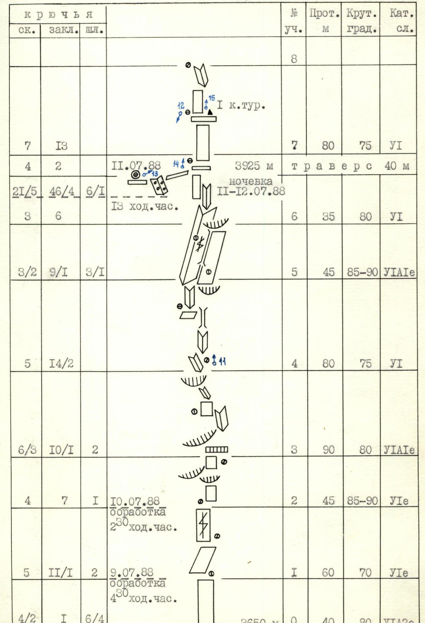
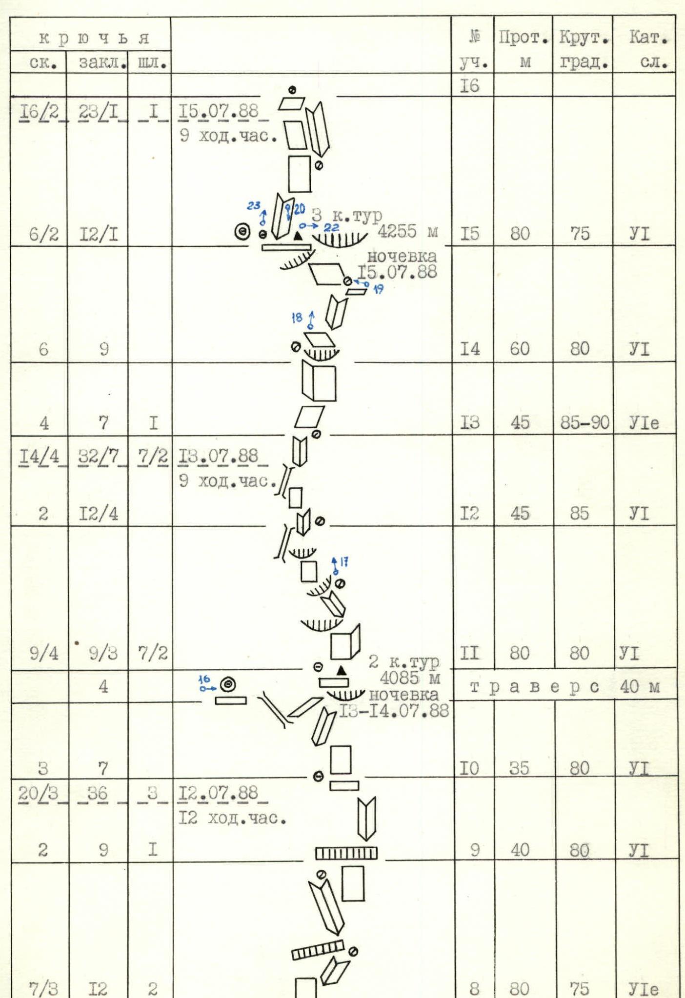
| Section (№) | Length (m) | Steepness (degrees) | Category |
|---|---|---|---|
| 0 | 40 | 80 | 6А2e |
| 1 | 60 | 70 | 6e |
| 2 | 45 | 85–90 | 6e |
| 3 | 90 | 80 | 6А1e |
| 4 | 80 | 75 | 6 |
| 5 | 45 | 85–90 | 6А1e |
| 6 | 35 | 80 | 6 |
| Traverse | 40 | ||
| 7 | 80 | 75 | 6 |
| 8 | 80 | 75 | 6e |
| 9 | 40 | 80 | 6 |
| 10 | 35 | 80 | 6 |
| 11 | 80 | 80 | 6 |
| 12 | 45 | 85 | 6 |
| 13 | 45 | 85–90 | 6e |
| 14 | 60 | 80 | 6 |
| 15 | 80 | 75 | 6 |
| 16 | 55 | 65–80 | 6А2m |
| 17 | 35 | 65 | 6А2 |
| 18 | 45 | 70 | 6 |
| 19 | 130 | 60–80 | 6 |
| 20 | 45 | 60 | 6А1 |
| 21 | 400 | 40 | 5Б |
| 22 |
Description of the route by sections
Section R0–R1. The route starts from the rantkluft up a vertical slab without holds. 20 m of bolted work straight up, then along a weak dihedral to the right and upwards. Belay point on bolted pitons. 40 m, 80°, 6А2e. Section R1–R2. The wall is somewhat gentler, but the terrain is the same. Weak internal corners formed by the main wall and outgrowths. Hanging belay points, climbing is difficult. 60 m, 70°, 6e. Section R2–R3. The wall becomes vertical. The number of places for organizing intermediate belays is limited. General direction of movement is straight up. 45 m, 85–90°, 6e. Section R3–R4. The section starts with a cornice, which is overcome on the left side using IT. Then 20 m to the right and upwards along the junction of a steep slab and an overhang. Climbing is very difficult. After the overhang ends, 20 m straight up along a smooth internal corner using bolted pitons for belay. The corner leads to a small oblique ledge, where a belay point is organized on nuts. From the belay point straight up, extreme climbing through an overhang for 4 m. Then along an internal corner to the left and upwards. Relatively convenient belay point. 90 m, 80°, 6А1e. Section R4–R5. Vertical internal corner turning into a chimney. The chimney leads to a convenient ledge. Belay point on pitons. Then again along an internal corner towards a powerful dihedral- chimeny. Belay point on a small ledge. 80 m, 75°, 6. Section R5–R6. Extreme climbing along a dihedral, occasionally using IT. Large nuts go well. The dihedral is capped by a cornice. Directly on the cornice, a bolted piton. The cornice is bypassed on the left with an exit to the outer side of the dihedral, which is the right wall of a powerful internal corner. Belay point in the corner on bolted pitons and nuts. 45 m, 85–90°, 6e. Section R6–R7. Vertical internal corner. First 20 m along the corner, then, moving to the left outer side, straight up along small holds. Climbing is difficult. Exit to a horizontal shelf. 35 m, 80°, 6. Convenient belay point. Along the shelf to the left, traverse 40 m. The traverse leads to a convenient platform for an overnight stay. There is snow. Section R7–R8. Along the slab straight up to a horizontal shelf (40 m). On the shelf, a control cairn. From the shelf, 20 m along a vertical wall turning into an internal corner. At the top of the internal corner, an inconvenient belay point. Total length of the section — 60 m, 75°, 6. Section R8–R9. Along the vertical wall to the right and upwards (10 m). Then along a relatively gentle internal corner-dihedral. Belay point on bolted pitons. The corner is capped by a cornice. Having overcome the cornice, you enter the next internal corner, going to the left and upwards. Hanging belay point under the cornice. 80 m, 75°, 6e. Section R9–R10. First, 15 m traverse to the right along a vertical wall. Then through a cornice and 20 m along an internal corner to a convenient horizontal shelf. On the right side of the shelf, there are "live" rock blocks. It's better not to touch them. 40 m, 80°, 6. Section R10–R11. Along a steep slab straight up, then along an internal corner overhanging at the top, exit to a shelf. 35 m, 80°, 6. Along the shelf, traverse to the left, first slightly down, then along a chimney upwards, exit to a horizontal shelf a meter wide. Overnight stay. Section R11–R12. On the shelf at the beginning of the section, a control cairn. The section starts with a vertical dihedral (25 m). Then to the left and upwards, an internal corner towards an overhang. Under the overhang, a belay point on bolted pitons and nuts. The rock is very hard — quartz. Two bolts were broken on this section. The section is characterized by alternating extreme free and artificial climbing. Through a series of overhangs and cornices to the left and upwards towards an internal corner. Climbing is very difficult, sometimes extreme. The wall is a series of "inverted" outgrowths of small sizes (2–5 m in length), so movement is zigzag, having to "wander" along the wall, choosing sections for free climbing. 80 m, 80°, 6А1e. Section R12–R13. Along a vertical wall 10 m to the left and upwards to a dihedral-chimney. After 15 m, the chimney ends, turning into a crack in an internal corner. Very steep. Climbing is extreme, sometimes IT. Hanging belay point on small stoppers. 45 m, 85°, 6. Section R13–R14. Along a vertical slab 15 m to the right and upwards to an internal corner, then along the right wall of the internal corner, bypassing an overhang on the right, exit to a gentle slab. Belay point on bolted pitons. 45 m, 85–90°, 6e. Section R14–R15. Along a wet internal corner to the right and upwards to a small ledge (35 m). Then under the cover of a powerful cornice to the left and upwards (25 m) towards a "throat" between cornices. Behind the "throat", there is an excellent horizontal shelf for an overnight stay. On the shelf, a control cairn. 60 m, 80°, 6. Section R15–R16. Along the shelf to the left to an internal corner. The internal corner is climbed using free climbing, with nuts going well. Then along a slab to a small ledge. Belay point behind a выступ. From the belay point, a smooth slab forming the left side of a smooth internal corner. Movement along the internal corner is very difficult climbing, sometimes using IT. Belay point on a wide gentle slab. 80 m, 75°, 6. Section R16–R17. Along the slab to the left, bypassing a powerful overhang, then straight up under a cornice. The cornice is overcome on the left side along a crack on IT. The crack turns into a chimney with absolutely smooth walls. After 10 m of movement along the chimney, a transition to the left (5 m) into an internal corner. Along the corner straight up to a small ledge. On it, a belay point on large nuts. After another 10 m, a convenient shelf. Here, a belay point is organized on pitons. 55 m, 65–80°, 6А2m. Section R17–R18. From the belay point to the right, a steep slab with a crack. Along the crack, free climbing leads into a monolithic couloir filled with dense snow. The left wall of the couloir is vertical. Along the wall, a crack into which medium nuts and channels fit well. IT. Exit from the couloir to the right onto a small shoulder. Belay point on a powerful выступ. 35 m, 65°, 6А2. Section R18–R19. Straight up along an internal corner. The corner is capped by a powerful overhang. Bypassing the overhang on the right and overcoming a cornice, exit to a small snow shelf with snow. Belay point on pitons. 45 m, 70°, 6. Section R19–R20. To the right and upwards (30 m) along a smooth internal corner. Climbing is very difficult, sometimes on wet rocks. Then along a monolithic slab (15 m) to a horizontal shelf, on which there is a convenient belay point on nuts. From the belay point, 20 m straight up along a steep wall. Holds are small, climbing is extreme. Then 40 m along a monolithic internal corner. In the middle of the corner, a hanging belay point. The internal corner turns into a chimney. At the top of the chimney, a belay point on pitons. 130 m, 60–80°, 6. Section R20–R21. From the belay point to the left and upwards, a wide internal corner. There are practically no holds. Climbing is extreme, sometimes on IT. The corner leads to the North ridge. 45 m, 60°, 6А1. Section R21–R22. Section of a classified route of category 5B along the North ridge to peak 4810 m. The ridge is not pronounced. There are walls and slabs of varying steepness and length. Nuts go well. 400 m, 40°, 5Б. Descent from the summit along the North ridge via a route of category 5B.
EQUIPMENT TABLE
| № | Name | Quantity |
|---|---|---|
| 1 | UIAA rope 45 mm 11 mm | 2 pcs |
| 2 | USSR rope 45 mm 10 mm | 6 pcs |
| 3 | Pamir tent | 1 pc |
| 4 | Hammock-tent | 1 pc |
| 5 | Hammock | 1 pc |
| 6 | Raincoats | 2 pcs |
| 7 | Primus stove with fuel | 1 pc |
| 8 | Gasoline | 1.5 l |
| 9 | Gas burner with cylinder | 1 pc |
| 10 | Autoclave + saucepan | 1+1 pc |
| 11 | Radio "Lastochka" | 1 pc |
| 12 | Power supply for radio | 1 kg |
| 13 | Medical kit | 2 kg |
| 14 | Flashlights | 2 pcs |
| 15 | Titanium rock pitons | 41 pcs |
| 16 | Bolted pitons | 70 pcs |
| 17 | Drill / punch / | 6 pcs |
| 18 | Placement elements (friend, stopper, sector). Total | 45 pcs |
| 19 | 8 l water flask | 1 pc |
| 20 | 0.5 l water flask | 6 pcs |
| 21 | Chain, cable | 2 pcs |
| 22 | Titanium carabiners | 70 pcs |
| 23 | Belay device | 12 pcs |
| 24 | Quickdraws | 36 pcs |
| 25 | Ring ladders | 4 pcs |
| 26 | Hook sticks | 12 pcs |
| 27 | Skyhook | 4 pcs |
| 28 | Helmets | 6 pcs |
| 29 | Harness | 6 pcs |
| 30 | Backpack + mat + polyethylene | 6 pcs |
| 31 | Rock shoes | 4 pairs |
| 32 | Vibram | 6 pairs |
| 33 | Down sleeping bag (leg) | 6 pcs |
| 34 | Down jacket | 6 pcs |
| 35 | Matches | 6 boxes |
| 36 | Descent and belay device | 6 pcs |
| 37 | Watches | 3 pcs |
| 38 | Camera + film | 2 pcs |
| 39 | Route documentation | 1 set |
| 40 | "Prusik" loops | 12 pcs |
| 41 | Rock hammers | 3 pcs |
5 backpacks were taken on the route. The weight of the backpack at the exit, excluding equipment, was 11.5 kg. 11.5 kg of food was taken on the route.
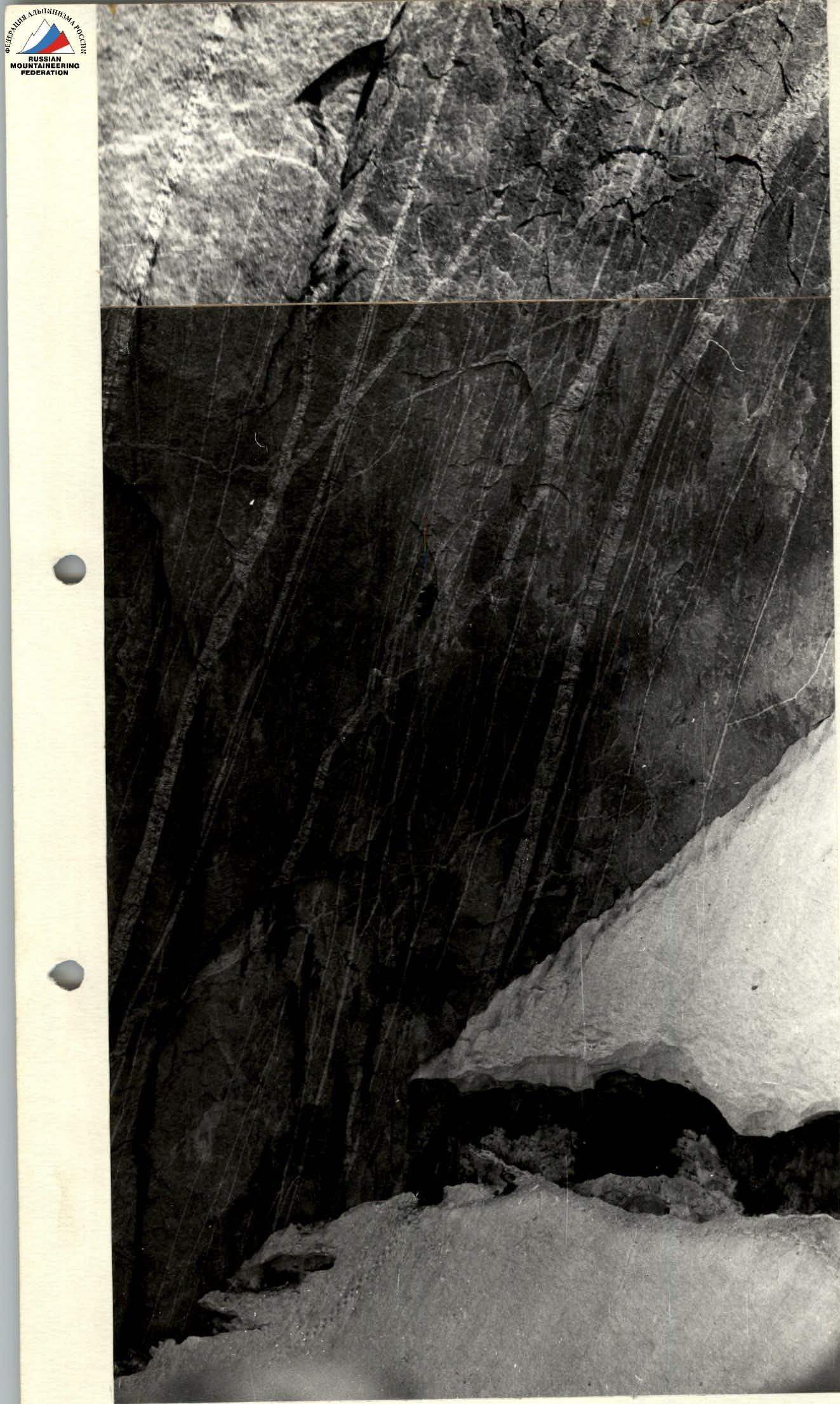
Photo — 10. Start of the route. Dorofeev A. is working first.
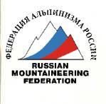
Photo — 9. Profile of the 3rd wall from the right.

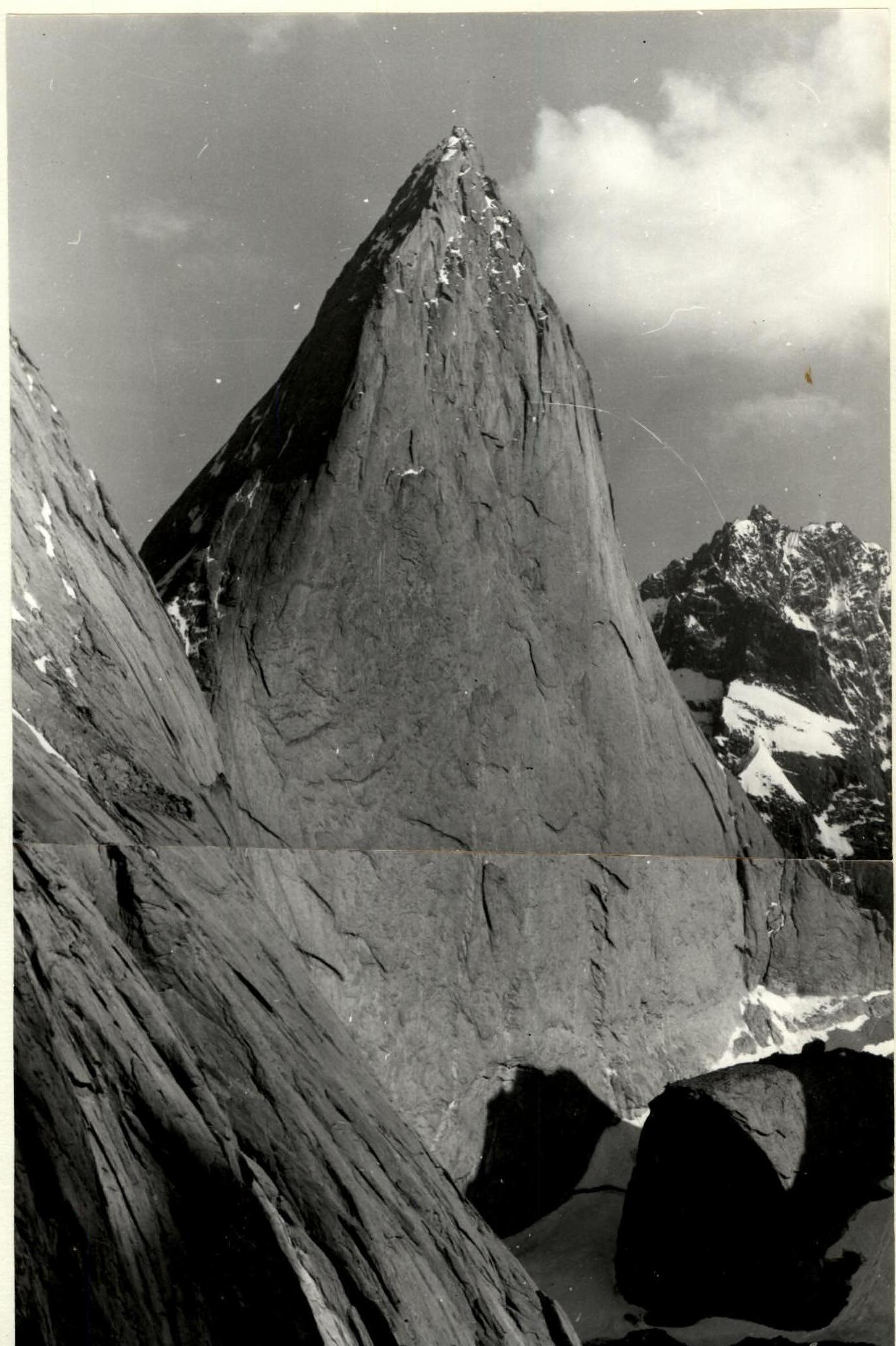
Photo — 7. Peak 4810. View from the west.
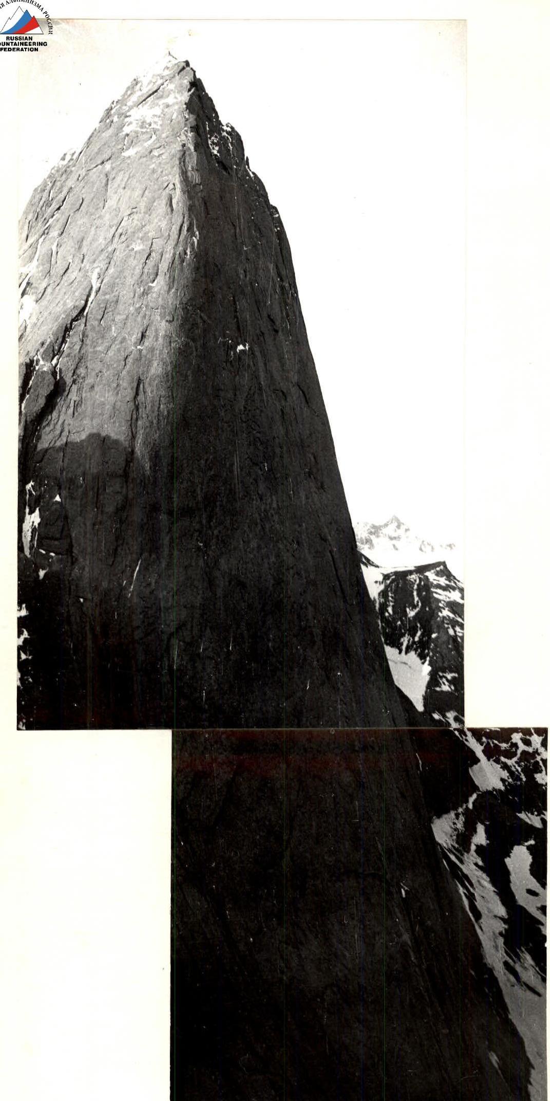
Photo — 8. Peak 4810. View from 10° from peak 4520.