PASSPORT 23xe
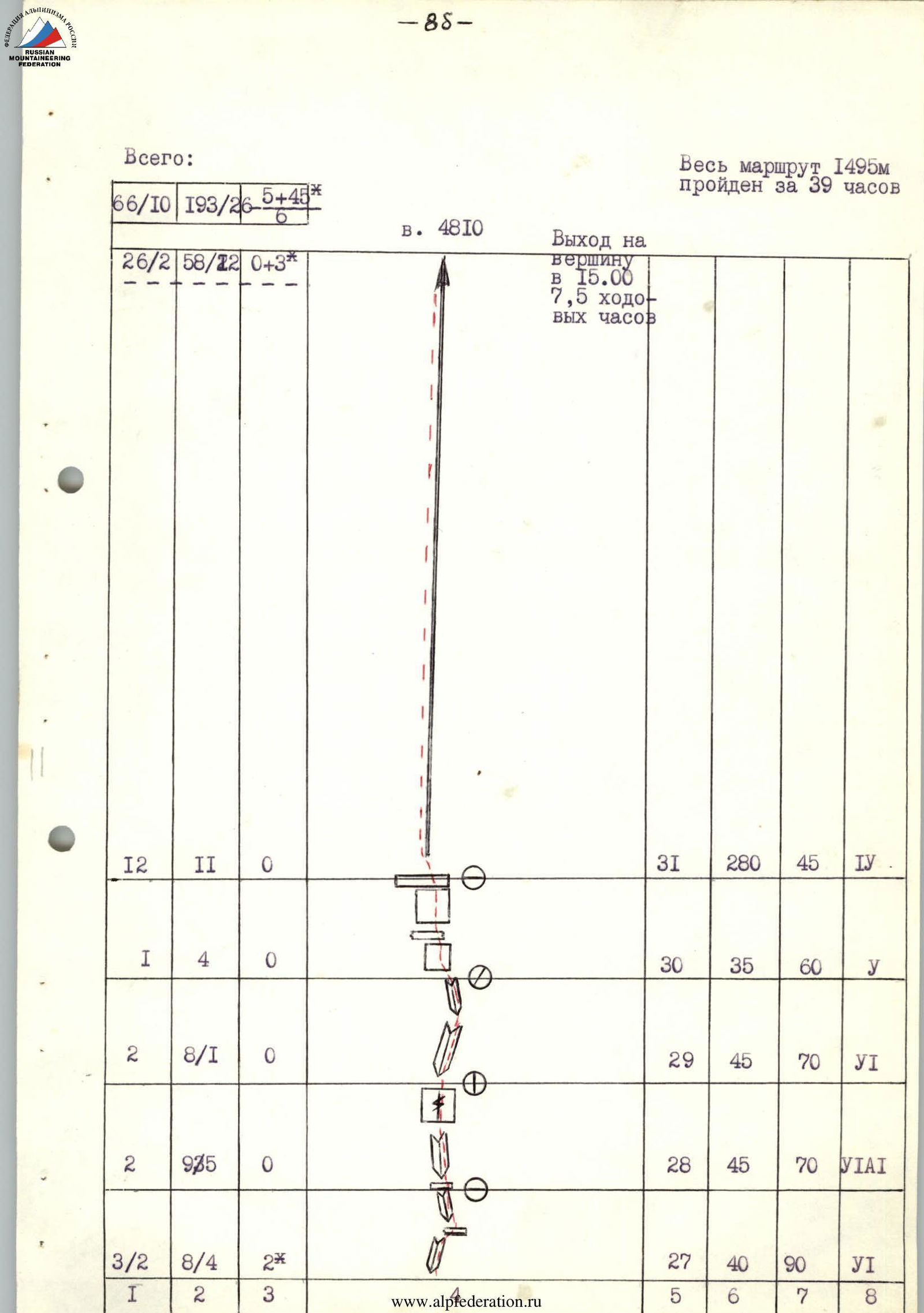
I. Class of technical ascents. 2. Pamir-Alay, Turkestan Ridge, Karavshin (Kara-Su) gorge. 3. Summit peak 4810 via the Center of the North-West wall (Rusyayev's route) 4. Difficulty category — 6B, fourth ascent. 5. Height difference — 1160 m, route length — 1495 m.
Length of sections with 5–6 difficulty category — 1220 m. Average steepness of the route — 68 degrees. Average steepness of the wall section of the route — 74 degrees.
- Pitons driven:
| Rock | Nuts | Bolt pitons |
|---|---|---|
| 65/10 | 193/26 | 5 + 45 /6 |
- Team's working hours — 39 hours, 5 days.
- Overnight stays — 3 bivouacs on snow ledges.
- Weather conditions: difficult, snow in the second half of the day.
- Captain: Ivanov Alexander Vasilyevich — CMS
Team members:
- Kurganov Nikolay Vladimirovich — CMS
- Piyanzin Vladimir Pavlovich — CMS
- Zhmaev Veniamin Vasilyevich — CMS
- Gadeev Ravil Gareyevich — CMS
II. Coach:
- Igolkin Viktor Ivanovich — Master of Sports of the USSR
- Route reconnaissance — July 14, 1989.
Departure on the route — July 15, 1989. Summit — July 18, 1989. Return to the camp — July 19, 1989.
- Organization — Alpinist Club of the Magnitogorsk Mining and Metallurgical Institute.

Photo 1. General photo of the summit. Taken on July 10, 1989 at 17:00 with a "Praktica" camera. Pentacon lens, focal length 26. Distance to the wall 600 m. Shooting point F₁ at an altitude of 3600 m. Routes:
- Kritsuk - 6B category.
- Rusyayev - 6B category.
- Voronov - 6B category.
- Kopeykin - 6B category.
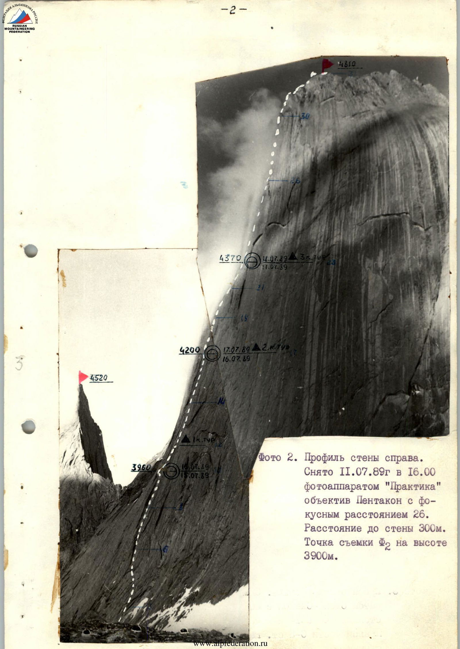
Photo 2. Profile of the wall on the right. Taken on July 11, 1989 at 16:00 with a "Praktica" camera, Pentacon lens with a focal length of 26. Distance to the wall 300 m. Shooting point F₂ at an altitude of 3900 m.
Photo 3. Profile of the wall on the left. Taken on July 3, 1988 at 15:00 with a "Smena-Symbol" camera with a T-43 lens with a focal length of 40 mm from the 1st bivouac on the route to peak 4520 via the Right part of the NW wall. Distance to the wall 1000 m. Shooting point F₃ at an altitude of

Photo 4. Photopanorama of the area. Taken from a helicopter in 1987. Distance to the object 4 km.
- Route via the left part of the NW wall, 6B category (Skripko)
- Route via the right part of the NW wall, 6B category (Igolkin)
- Route via the Ridge, 5B category (Sitnikov)
- Route via the center of the NW wall, 6B category (Kritsuk)
- Route via the center of the NW wall, 6B category (Rusyayev)
- Route via the center of the NW wall, 6B category (Voronov)
- Route via the center of the NW wall, 6B category (Kopeyka)
Routes on peak Asan via the NW wall, 5B, 6A, 6B category (Moroz, Pogorelov, Gorbenko, Rusyayev, Timofeyev, Alperin)
The tactical plan for the route was prepared by the team in two versions.
- One day of reconnaissance with descent to the camp at the moraine under the route and two overnight stays on the route.
- One day of reconnaissance and three overnight stays on the route.
The first version of the route was planned for favorable weather, and the second version — for the case of bad weather during the ascent.
The tactical plan included the order of work for the rope teams and linking the movement schedule to control points on the route — bivouac sites (control cairns).
However, adjustments were made to the order of work for the rope teams during the ascent because one of the participants, Rozin I., fell ill on July 14 and had to descend to the base camp.
Due to difficult weather conditions, the team followed the second version of the tactical plan.
The team worked on the route in the following order:
- July 14 — the Piyanzin–Kurganov rope team reconnoitered the route.
- July 15 — Piyanzin–Kurganov worked first.
- July 16 — Zhmaev–Gadeev and Ivanov–Zhmaev rope teams worked first.
- July 17 — Zhmaev–Gadeev and Gadeev–Ivanov rope teams worked first.
- July 18 — Zhmaev–Gadeev rope team worked first, thus evenly loading all team members.
According to the tactical plan, on July 14 at 12:00, the team began reconnaissance and, having climbed five pitches, descended due to bad weather (snow started at 15:30).
On July 15, the team started moving along the fixed ropes at 7:00, climbed above the first control cairn, and stopped for the night on the "Mitten" due to bad weather at 15:00.
On July 16 — it snowed from morning till 15:00, and as soon as the wall dried a bit, the team started moving along the fixed ropes and above. They reached the second control cairn and fixed three more pitches before nightfall, and bivouacked at the 2nd control cairn.
On July 17 — starting at 7:00, the team reached the third control cairn at 15:00, fixed three pitches, and descended for the night because it started snowing.
On July 18 — at 8:30, leaving the bivouac site, they reached the ridge at 13:00. They reached the summit at 15:00 but bivouacked on the ridge due to bad weather.
On July 19 — they descended to the base camp at 16:00. The ascent utilized the entire arsenal of modern technical means: skyhooks, friends, and screw-in pitons.
For safety, the first climber always worked on a double rope, one of which was "Edelrid" (FRG) UIAA, and the others were backup.
All belay stations were organized on at least three points.
Nutrition during the ascent was two meals a day:
- in the morning
- in the evening
With the use of additional individual high-calorie nutrition during movement on the route.
Communication with observers under the route was maintained via RTP-70 radio station, and the team's movement was monitored with binoculars.
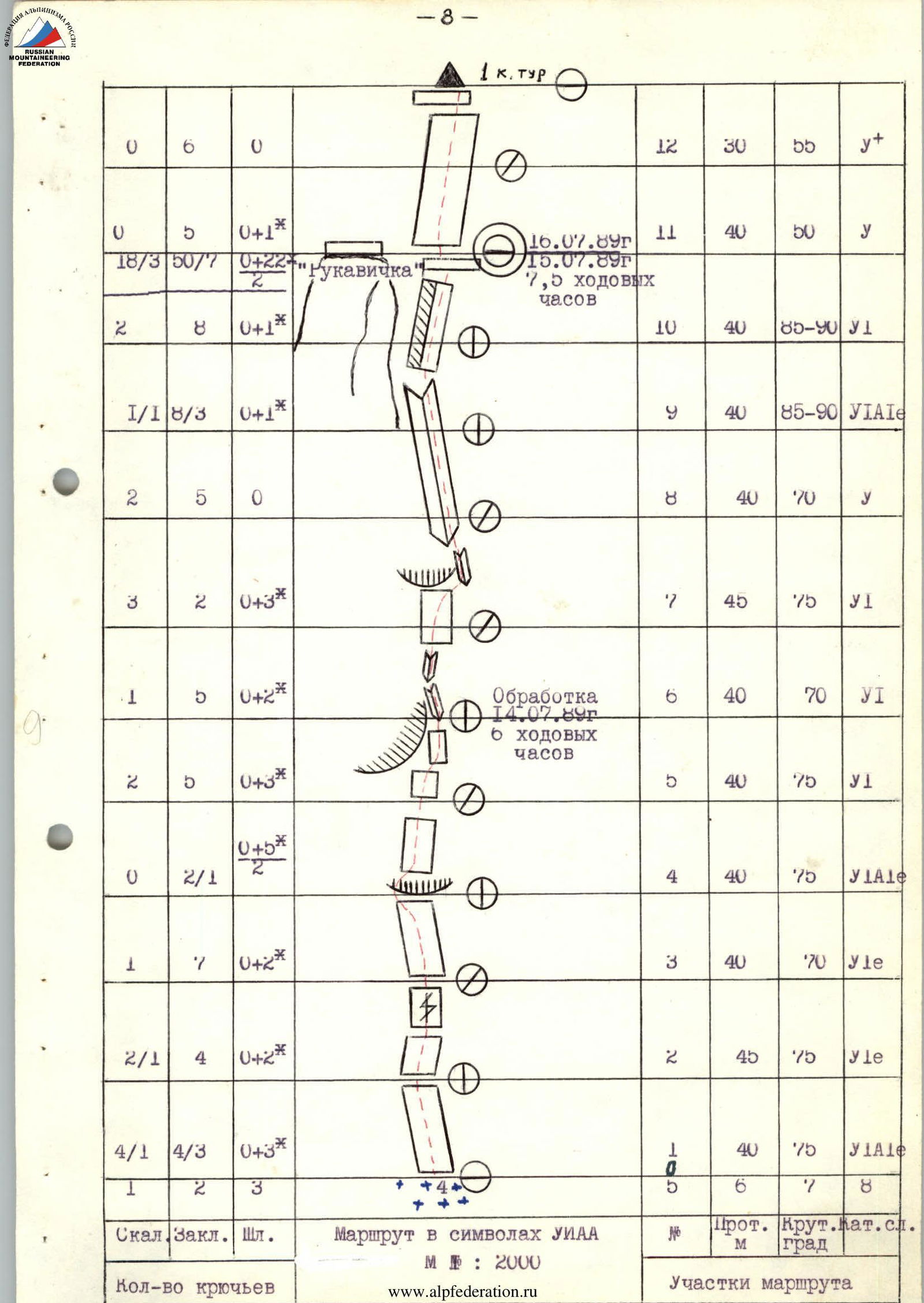
| Section № | Rock | Nuts | Bolt | Length, m | Steepness, ° | Difficulty category | Scheme of the section | Note |
|---|---|---|---|---|---|---|---|---|
| R1 | 4/1 | 4/3 | 0+3* | 40 | 75 | y₁A1e | ||
| R2 | 2/1 | 4 | 0+2* | 45 | 75 | y₁e | ||
| R3 | 1 | 7 | 0+2* | 40 | 70 | y₁e | ||
| R4 | 0 | 2/1 | (0+5*)/2 | 40 | 75 | y₁A1 | ||
| R5 | 2 | 5 | 0+3* | 40 | 75 | y₁ | ||
| R6 | 1 | 5 | 0+2* | 40 | 70 | y₁ | Reconnaissance on July 14, 1989, 6 working hours | |
| R7 | 3 | 2 | 0+3* | 45 | 75 | y₁ | ||
| R8 | 2 | 5 | 0 | 40 | 70 | y | ||
| R9 | 1/1 | 8/3 | 0+1* | 40 | 85–90 | y₁A1e | ||
| R10 | 2 | 8 | 0+1* | 40 | 85–90 | y₁ | ||
| R11 | 0 | 5 | 0+1* | 40 | 50 | y | Bivouac "Mitten" on July 16, 1989 / July 15, 1989, 7.5 working hours | |
| R12 | 0 | 6 | 0 | 30 | 66 | y+ | ||
| R13 | 2 | 6 | 0+3* | 40 | 75 | y+ |  | |
| R14 | 3/2 | 8/2 | 2+2* / 2 | 45 | 90 | y₁A2 |  | Reconnaissance on July 15, 1989, 2.5 working hours |
| R15 | 1 | 8 | 0+2* | 40 | 80 | y₁ | ||
| R16 | 3/1 | 7/2 | 0+4* / 2 | 40 | 90 | y₁A1 |  | Traverse |
| R17 | 2 | 9 | 0 | 45 | 75 | y |  | 2nd control cairn on July 17, 1989 / July 16, 1989, 5 working hours |
| R18 | 1 | 6 | 0+2* | 40 | 85 | y₁ |  | |
| R19 | 2 | 7 | 1+2* | 40 | 85 | y₁ | ||
| R20 | 1 | 6 | 1+2* | 40 | 80 | y₁ |  | |
| R21 | 2 | 5 | 0+1* | 40 | 80 | y₁ |  | Reconnaissance on July 16, 1989, 2.5 working hours |
| R22 | 3/2 | 8/2 | 1+1* | 40 | 85 | y₁A1 | ||
| R23 | 2/2 | 36/3 | 3+8* | 30 | 80 | y₁ |  | July 17, 1989, 6 working hours |
| R24 | 2 | 6 | 0+1* | 40 | 80 | y₁ | 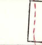 | 3rd control cairn on July 18, 1989 / July 17, 1989 |
| R25 | 2 | 1/2 | 0 | 40 | 75 | y₁ | ||
| R26 | 2 | 5 | 0 | 40 | 75 | y+ | 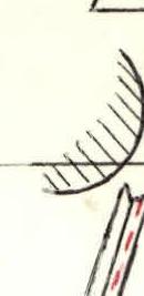 | Reconnaissance on July 17, 1989, 4 working hours |
| R27 | 3/2 | 8/4 | 2* | 40 | 90 | У1 | ||
| R28 | 2 | 9/5 | 0 | 45 | 70 | У1А1 | ||
| R29 | 2 | 8/1 | 0 | 45 | 70 | У1 | ||
| R30 | 1 | 4 | 0 | 35 | 60 | y | ||
| R31 | 12 | 11 | 0 | 280 | 45 | IY | Reached the summit at 15:00, 7.5 working hours | |
| Total: | 66/10 | 193/26 | 5+45/6** | The entire route of 1495 m was completed in 39 hours | ||||
| 26/2 | 58/22 | 0+3* |
Description of the route by sections
1–3 — Monolithic slab with a minimal number of holds. Belay points on bolt pitons. Climbing is difficult. 4. Cornice. Overcome in the left part. Then upwards along the monolithic slab with a minimal number of holds. Climbing is difficult. Skyhooks and bolt pitons are used for belay organization. 5. — Overhang. Bypass in the direction of large cracks and an oblique corner. 6–7 — Large cracks. Through the cracks, entry into a large oblique corner. 8–9 — Oblique corner. Movement along the oblique corner towards the overhanging corner. 10 — Overhanging corner. Movement upwards along the corner. Climbing is difficult with the use of artificial aids (IT). A small ledge, "Rukaavichka" bivouac on the left. 11–12 — The wall becomes gentler. Rocks are smoothed by water flows. Exit to a ledge. 1st control cairn. 13 — Steepness increases. Monolithic wall with few holds. Movement initially upwards, then to the right of a large cornice. 14 — Large cornice. Bypassed on the right through large cracks and slabs that are detached from the wall. Sufficiently strong. Entry into a steep corner. Climbing is difficult. 15 — Movement upwards along the corner under the cornice. Climbing is difficult. 16 — Under the cornice, traverse to the right using skyhooks and IT. Entry into the corner. Then upwards along the corner, exiting to a ledge. Climbing is difficult. 17 — Exit to a ledge along the corners. 2nd control cairn. Good bivouac site. 18–19 — Monolithic wall with a sufficient number of holds. Movement towards a large, clearly defined corner. 20 — Upwards along a small internal corner to a clearly defined corner. Pendulum move to the right. Entry into a clearly defined corner. Climbing is difficult. 21 — Upwards along the corner, exiting to a small ledge. 22–23 — From the ledge, upwards along the right corner under the cornice. Bolt piton under the cornice. Pendulum move to the left. Entry into an internal corner leading to a ledge. Third control cairn. Climbing is difficult. 24–25 — Movement along the monolithic wall towards an overhanging corner with few holds. Then upwards along the overhanging corner. 26 — Upwards along the overhanging corner with a clear gap. IT. Climbing is difficult. Exit to a ledge. 27 — Series of internal corners. Iced. IT. Lead to a small ledge. 28 — Internal corner leads to a wall. Iced. IT. 29 — Series of internal corners. Snow. Exit to a wall. 30 — Series of walls, exiting to the ridge. Good place for a bivouac. 31 — Ridge, not clearly defined. Various steep walls and slabs encountered.
Descent from the summit along the ridge towards peak 1000-letiye kreshcheniya Rusi (route 6B category).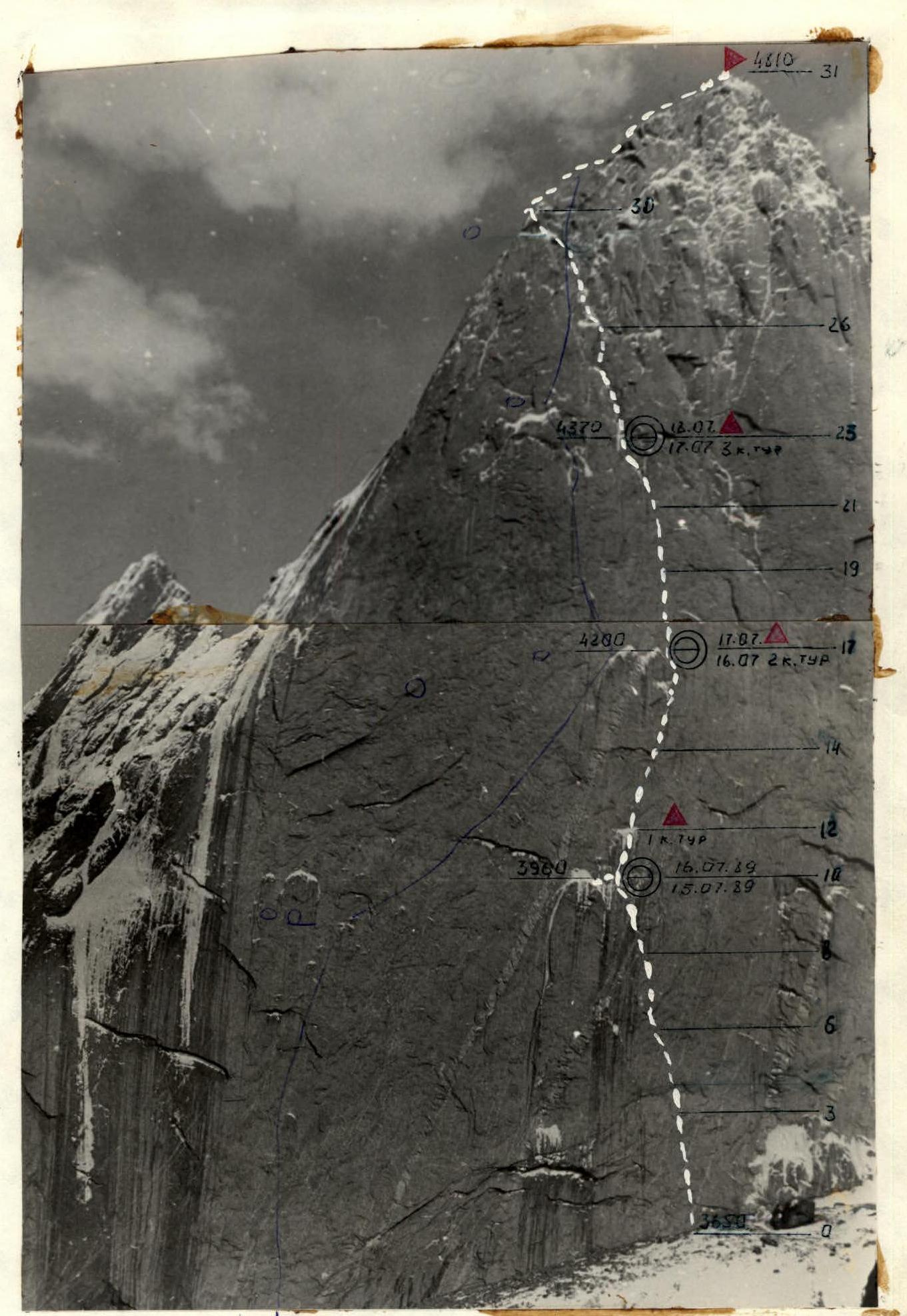
Photo 5. Technical photo of the route. Taken on July 7, 1989 at 16:00 with a "Praktica" camera. "Pentacon" lens with a focal length of 26. Distance to the wall 1500 m. Shooting point F5 at an altitude of 3900 m.