ASCENT DOCUMENT
- Region, gorges: Turkestan Ridge, Karavshin 5.4.3.
- Name of the peak: Peak Odessa, 4810 m, center of NW wall (Kritsuk Route).
- Proposed: 6B category of difficulty.
- Nature of the route: rock climbing.
- Route elevation gain: 1180 m.
Route length: 1526 m.
Length of sections:
- V category of difficulty: 520 m.
- VI category of difficulty: 836 m. Average steepness:
- main part of the route: 79°.
- entire route: 75°.
- "Hooks" left on the route:
total 3, including bolted — 2 pcs.
Hooks used on the route:
- stationary bolted: 47 pcs., including Aids — 5 pcs.
- removable bolted: 30 pcs., including Aids — 15 pcs. Total Aids used: 154 pcs., including skyhooks — 74 pcs.
- Team's working hours: 83 h, 9 days.
- Leader: Morozov D.V. CMS
Participants:
- Tarnakin Yu.A. CMS
- Kondrashov V.V. CMS
- Coach: Igolkin V.I. MS
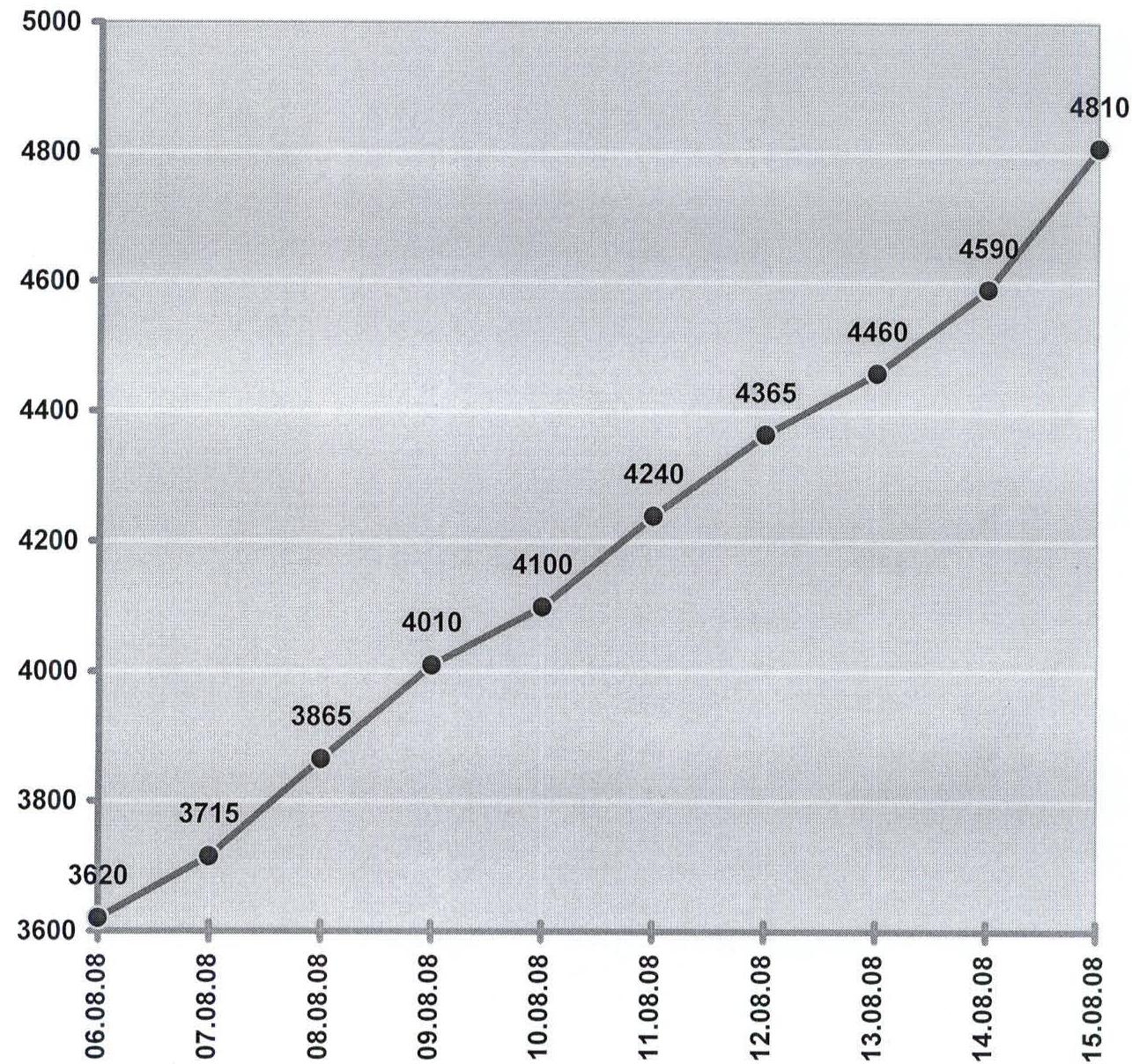
- Departure to the route: 7:00, August 7, 2008. Summit ascent: 7:00, August 15, 2008. Return to Base Camp: 20:00, August 15, 2008.
- Organization: Team of the Regional Sports Committee of the Chelyabinsk Region.
General photo of the peak Kritsuk Route, Rusyaev Route (approximately) Taken in August 2008 from the trail on the approach to 4810 m.
Drawn profile of the route
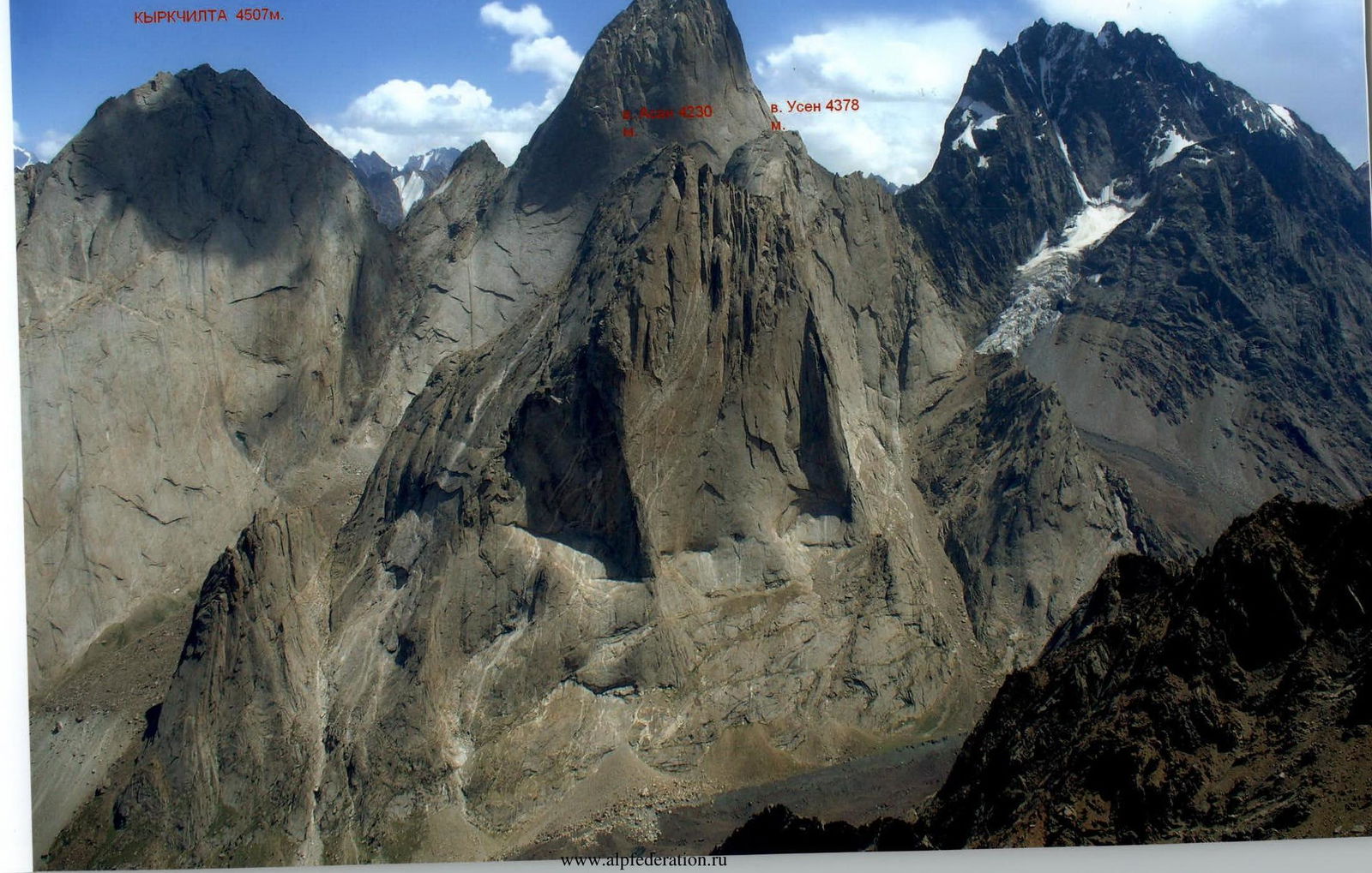
PHOTOPANORAMA OF THE REGION
KYRKCHILTA 4507 m
ASCENT SCHEDULE
| Work time, h | 10 | 9 | 8 | 9 | 9 | 8 | 9 | 8 | 3 |
|---|---|---|---|---|---|---|---|---|---|
| Wind, m/s | 2 | 2 | 3 | 3 | 2 | 2 | 2 | 4 | 4 |
| Temperature, °C | 15 | 16 | 18 | 18 | 20 | 18 | 17 | 16 | 15 |
| Weather conditions | |||||||||
| Natural phenomena |
UIAA SCHEME

| Anchor hooks | Placements | Bolts | Skyhooks | Removable bolts | Aids/Other | № | Description / Location / Date | Length, m | Steepness, deg. | Difficulty |
|---|---|---|---|---|---|---|---|---|---|---|
| 2/0 | – | – | – | – | – | 42 | 60 | 35 | II–III | |
| 4 | – | – | – | – | – | 41 | 40 | 45 | III | |
| 4 | 3 | – | – | – | – | 40 | 40 | 55 | III | |
| 1 | 1 | – | – | – | – | 39 | 15 | 48 | IV | |
| – | 7 | – | – | – | – | 38 | 50 | 45 | IV | |
| 3/1 | 4/1 | – | – | – | – | 37 | 50 | 50 | IV | |
| 2/0 | 7 | – | – | – | – | 36 | 45 | 55 | IV | |
| 4 | 5 | – | – | – | – | 35 | Ridge | 45 | 60 | IV–V |
| 1/0 | 6 | – | – | – | – | 34 | Exit to the ridge | 25 | 70 | V |
| 3 | 5 | – | – | – | – | 33 | 45 | 70 | V | |
| 4 | 5 | 1/0 | – | – | – | 32 | 45 | 75 | V | |
| 6 | 5 | 2/0 | – | – | – | 31 | 50 | 78 | A2, V 5 m | |
| 4/4 | 4/2 | 2/1 | – | – | – | 30 | 15 | 85 | A2 | |
| 8/6 | 9/6 | 5/3 | 5/3 | 2 | – | 28 | Photo №6 | 50 | 85 | A3e, V 15 m |
| 8 | 9 | 2/0 | – | – | – | 27 | KT №2, August 13–14, 4380 m, Petzl eye bolt | 40 | 85 | A2, V 20 m |
| 5 | 6 | 1/0 | – | – | – | 26 | 25 | 80 | A2 | |
| 7/4 | 3/1 | – | – | – | – | 25 | 25 | 80 | A2 | |
| 10/8 | 12/8 | 1/0 | – | – | – | 24 | 50 | 83 | A1 | |
| 7/3 | 8/4 | 2/1 | – | – | – | 23 | Photo №5 | 50 | 85 | A2e, V 15 m |
| 4/4 | 7/7 | 4/2 | –/3 | 2 | – | 22 | 50 | 83 | A4e | |
| 2/1 | 7/3 | 5/0 | – | – | – | 21 | KT №1, August 11–12, 4190 m, "Grudi" shelf | 40 | 80 | A1, V 15 m |
| 5 | 7/5 | 4/3 | – | – | – | 20 | 45 | 78 | A2e | |
| 4/2 | – | 4 | 8/8 | – | – | 19 | Photo №3 | 30 | 75 | A3e |
| 4/2 | 2/2 | 1/0 | 4/3 | – | – | 18 | 20 | 79 | A2e | |
| 12/5 | 4/4 | 2/1 | 7/3 | – | – | 17 | 45 | 75 | A3e | |
| 9/9 | 2/2 | 7/4 | 5/5 | – | – | 16 | 50 | 75 | A2e | |
| 4/0 | 10/0 | 3/0 | – | – | – | 15 | 4010 m, August 9–10, "Varezhka" shelf | 50 | 73 | VI 20 m, V 30 m |
| 5/3 | 12/7 | 3/0 | – | – | – | 14 | 45 | 73 | A2, VI 30 m | |
| 18/13 | 8/5 | 3/0 | – | – | – | 13 | 45 | 73 | A2, VI 10 m | |
| 2/1 | 9/4 | 3/1 | 3/– | – | – | 12 | 15 | 77 | A2e, VI 10 m | |
| 6/5 | 6/3 | 3/2 | 5/2 | – | – | 11 | 35 | 77 | A3e, VI 17 m | |
| 8/5 | 8/0 | 3/1 | – | – | – | 10 | Photo №2 | 40 | 75 | A2, V 15 m |
| 5/4 | – | 6/4 | 8/8 | – | – | 9 | 25 | 75 | A2e | |
| 8/2 | 2/1 | 4/2 | 3/2 | 2 | – | 8 | Cornice in the form of a bird | 20 | 80 | A3e, V 5 m |
| 3/2 | 5/2 | 1/0 | – | – | – | 7 | 3780 m | 20 | 80 | A2, IV 10 m |
| 3/2 | 4/1 | 3/2 | – | – | – | 6 | 15 | 55 | A2e, IV 5 m | |
| 1/1 | 5/1 | 6/3 | 10/– | 1 | – | 5 | 25 | 85 | A2e | |
| 5/3 | 19/19 | 5/2 | – | – | – | 4 | Photo №1, Living hanging "nashlepki" | 30 | 83 | A3, V 4 m |
| 14/12 | 6/4 | 2/2 | – | 1 | – | 3 | Large inner corner | 35 | 85 | A3e |
| 3/1 | 13/12 | 5/2 | 2/2 | – | – | 2 | 30 | 85 | A3 | |
| 4/3 | 4/3 | 8/6 | 5/6 | – | – | 1 | 3660 m, August 7–8 (3620 m) | 45 | 85 | A3e |
R34–R42, p. 4810, August 15, 2008.
R31
R27, August 13–14, 4380 m
R21, August 11–12, 4190 m
R15, August 9–10, 4010 m
R10
Technical photograph of the route R1, August 7–8, 3660 m
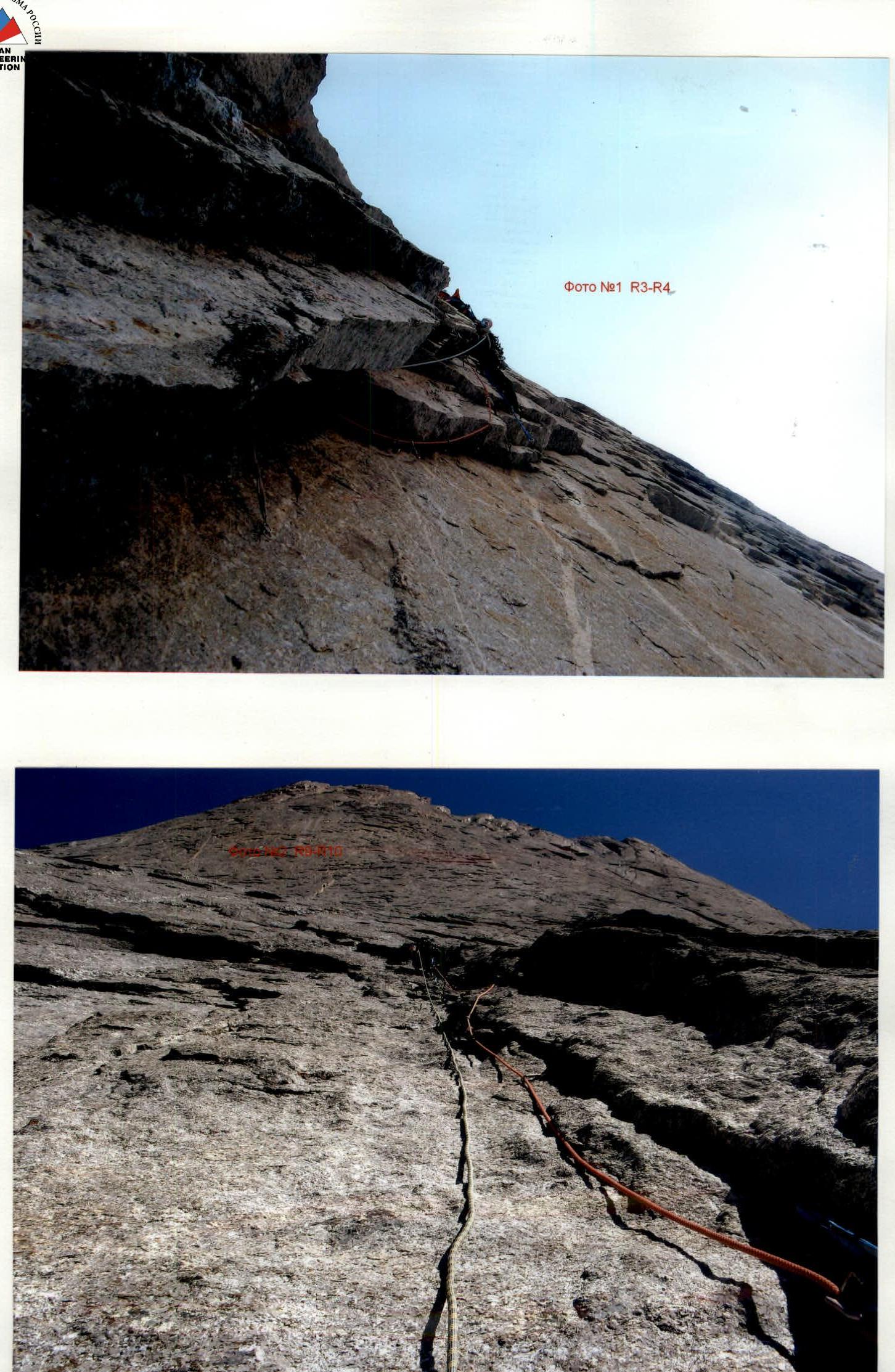
Photo №1 R3–R4

Photo №6 R27–R28
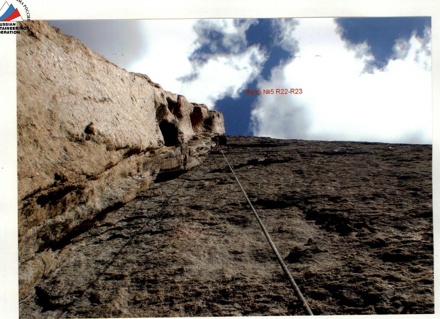
Photo №3
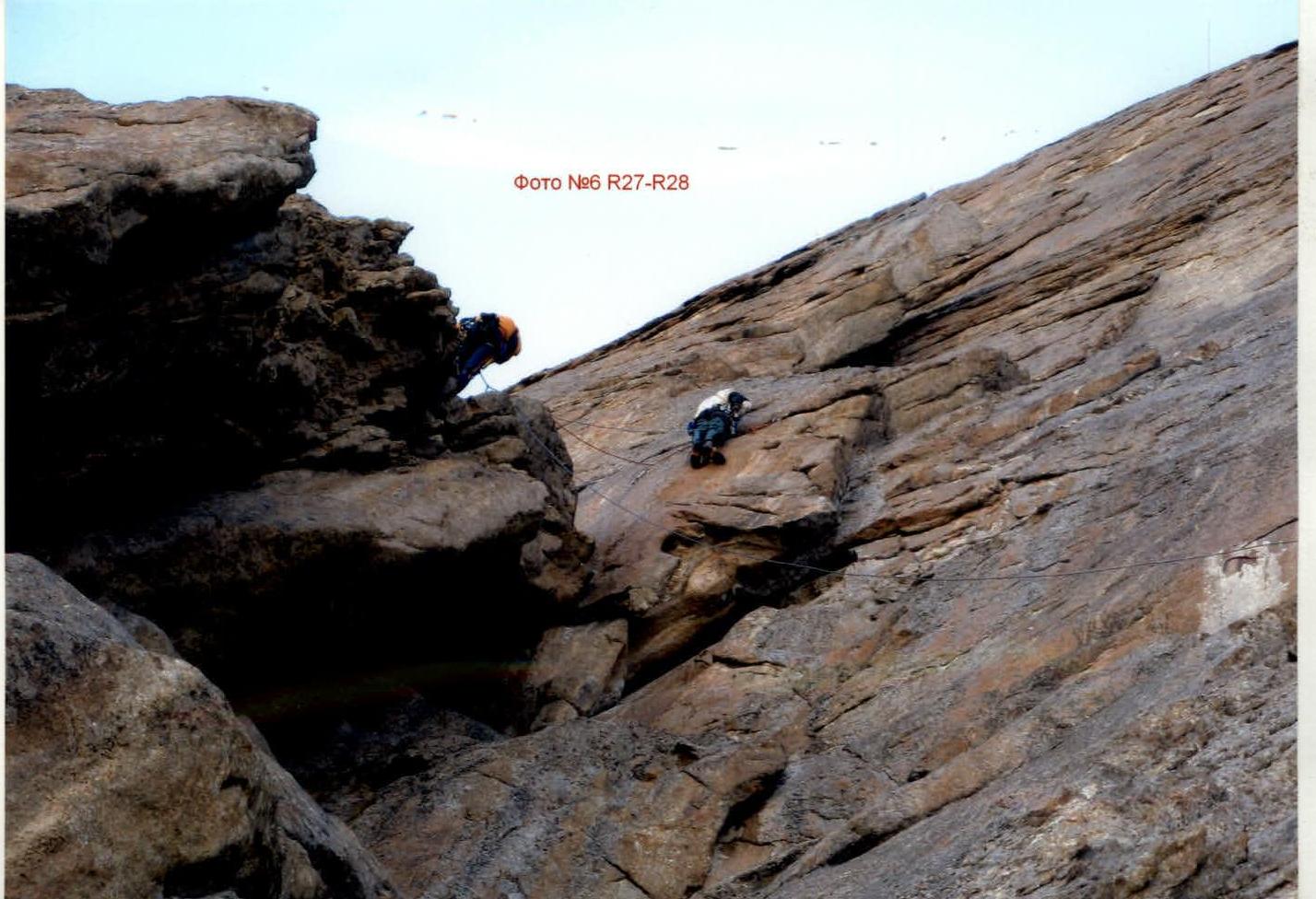
Photo №5 R22–R23

Peak 4810 summit. Kondrashov, Morozov. Tarnakin is taking the photo.