Passport
I. Technical class 2. Northern spurs of the Turkestan Range, Kara-Su gorge 3. Peak 4810 m, center of the northwest wall 4. Proposed 6B cat. sl. second ascent of Krishchuk's route 5. Height difference: 1160 m, length — 1480 m
Length of sections 5–6 cat. sl. — 825 m
Average steepness of the main part of the route 75° (3650–4670)
Of these, 6B cat. sl.:
- 80° (3650–3800, 3875–3915, 4110–4195, 4220–4280);
- 85° (4335–4460);
- 80° (4555–4610)
- Hammered in pitons:
rock 168/54, bolted pitons (10+23)/(3+7), chocks 199/101, sky hooks 29/0
- Team's working hours: 66 hours and 5 days
- Overnights: 1st — two in hammocks, four on shelves
2–3rd — comfortable on platforms, lying down; 4th — uncomfortable sitting for 6 people.
- Team leader: Shevchuk Alexander Denisovich — MS
Vladimir Badt Andreyevich — CMS, Gorshenin Sergey Gennadievich — CMS, Karpenkov Mikhail Vladimirovich — CMS, Lutsenko Vladimir Anatolyevich — CMS, Smirnov Mikhail Glebovich — CMS. 10. Coach: Retyunsky Yuri Dmitrievich — MS. 11. Exit to the route: July 17, 1988. Summit: July 21, 1988. Return: July 21, 1988. 12. Chelyabinsk Regional Sports Committee
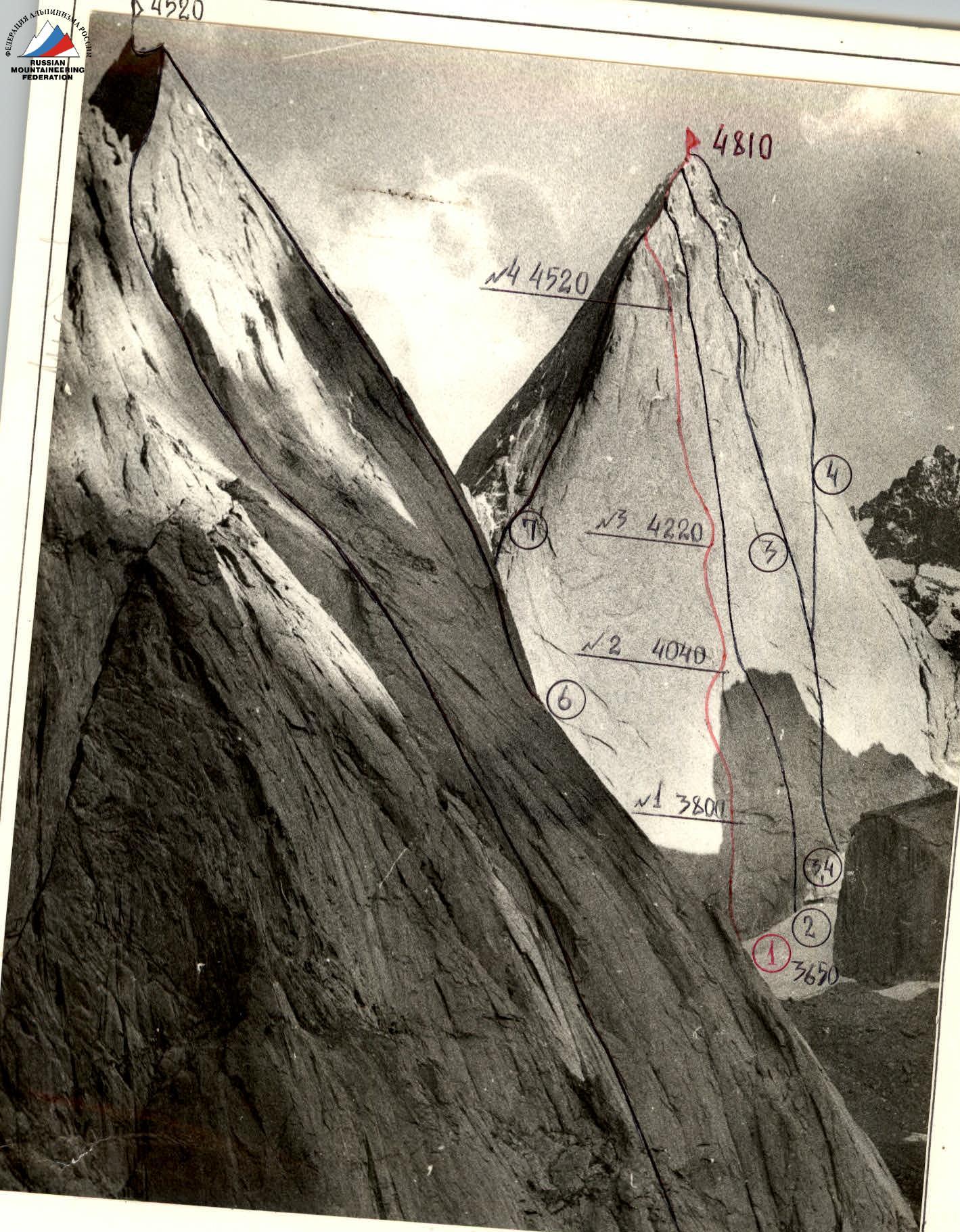
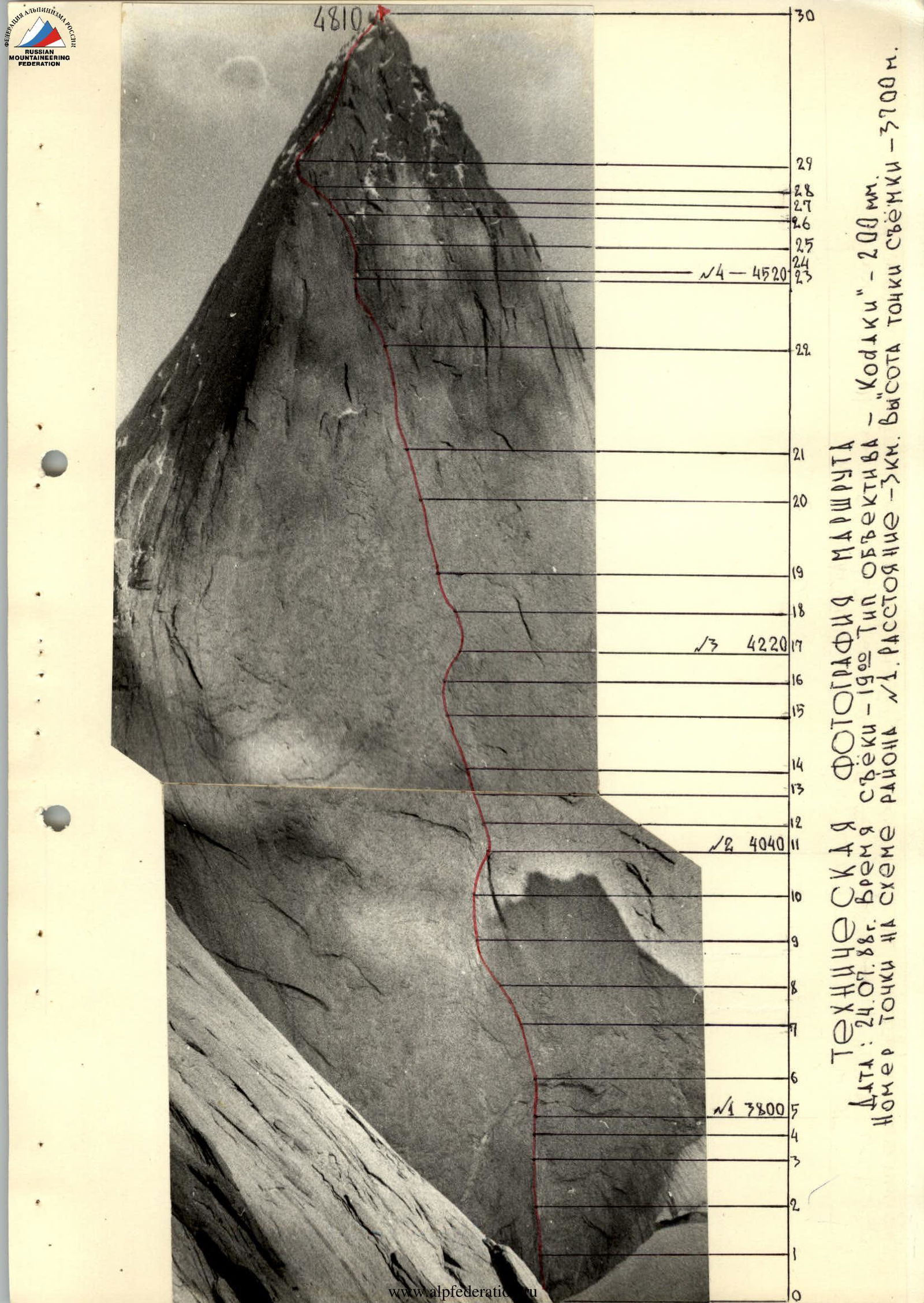
General photo of the summit. Routes to peak 4810:
- Kritsuka — 88
- Rusyaev — 88
- Solonnikov — 88
- Kharkov — 88
- Sitnik — 86 To peak 4520:
- Skripko — 88
- Igolkin — 88
Date: July 24, 1988. Time: 19:00. Lens: "Industar-42" — 58 mm. Distance: 2.6 km. Shooting point: # 1. Point height: 3700 m.
Tactical actions of the team
The team built its actions based on the tactical plan (option-2). The preceding two-day bad weather complicated the passage of the route (especially the lower part) — the hanging inner corner was wet. But there were no deviations in the time of passing control sections and overnight stays. During the day, each participant worked according to the tactical plan. The first to work on the route were:
Shevchuk A.D.R.:
- R1–R4
- R5–R7
- R21–R22
Lutsenko V.A.:
- R16–R20
- R6–R7
- R12–R14
- R23–R24
Karpenkov M.V.: R25–R30.
Group movement scheme: the first worked on a double rope with a shock absorber, the second with upper belay brings two free ropes and straightens the ropes along the way. The third and fourth — on double "perils", the fifth and sixth — on double "perils" with upper belay.
For safety purposes, belay points were organized on at least three blocked points. The overnight stays were chosen to be comfortable, lying down, under overhangs — the team had a full rest. Upon arrival at the overnight stay:
- four organized a bivouac;
- two — on processing.
Nutrition regime:
- morning and evening — hot meals;
- during the day — high-calorie dry rations.
The physical reserve of the team consisted of high overall physical fitness and uniform distribution of loads per day among participants. There were no failures or injuries during the ascent.
Interchangeability of each participant in any position, technical and individual rock climbing preparedness of the participants allowed to overcome problematic sections without delaying the group. Based on all this, the team's tactical actions on the route were developed.
Modern equipment samples were used to pass the route:
- friends;
- sky hooks;
- "hook legs";
- ring ladders;
- screw-out bolted pitons, etc.
In case of bad weather, in addition to the main route option, backup options were provided.
Communication with the base camp was regular — RPT-20 radio station; in case of radio failure, a color and light signal was provided.
The rescue team, during the ascent, was located in the base camp, had the appropriate qualifications and equipment to exit on this route. The rescue team included a surgeon.
Familiarization with the routes to peak 4810 began with the study of reporting documentation (descent route), consultations with the group of pioneers (led by Kristsuk G.) and continued as a result of:
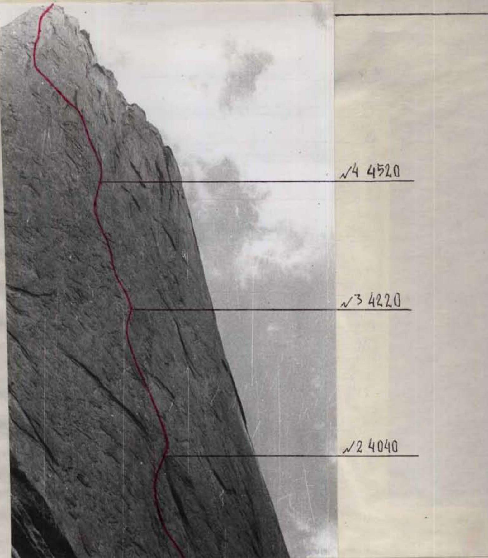
Left wall profile
- Date: July 17, 1988. Time: 15:00
- Lens: "Industar-42"
- Focal length: 58 mm
- Distance: 500 m
- Shooting point: # 3
- Point height: 3700 m
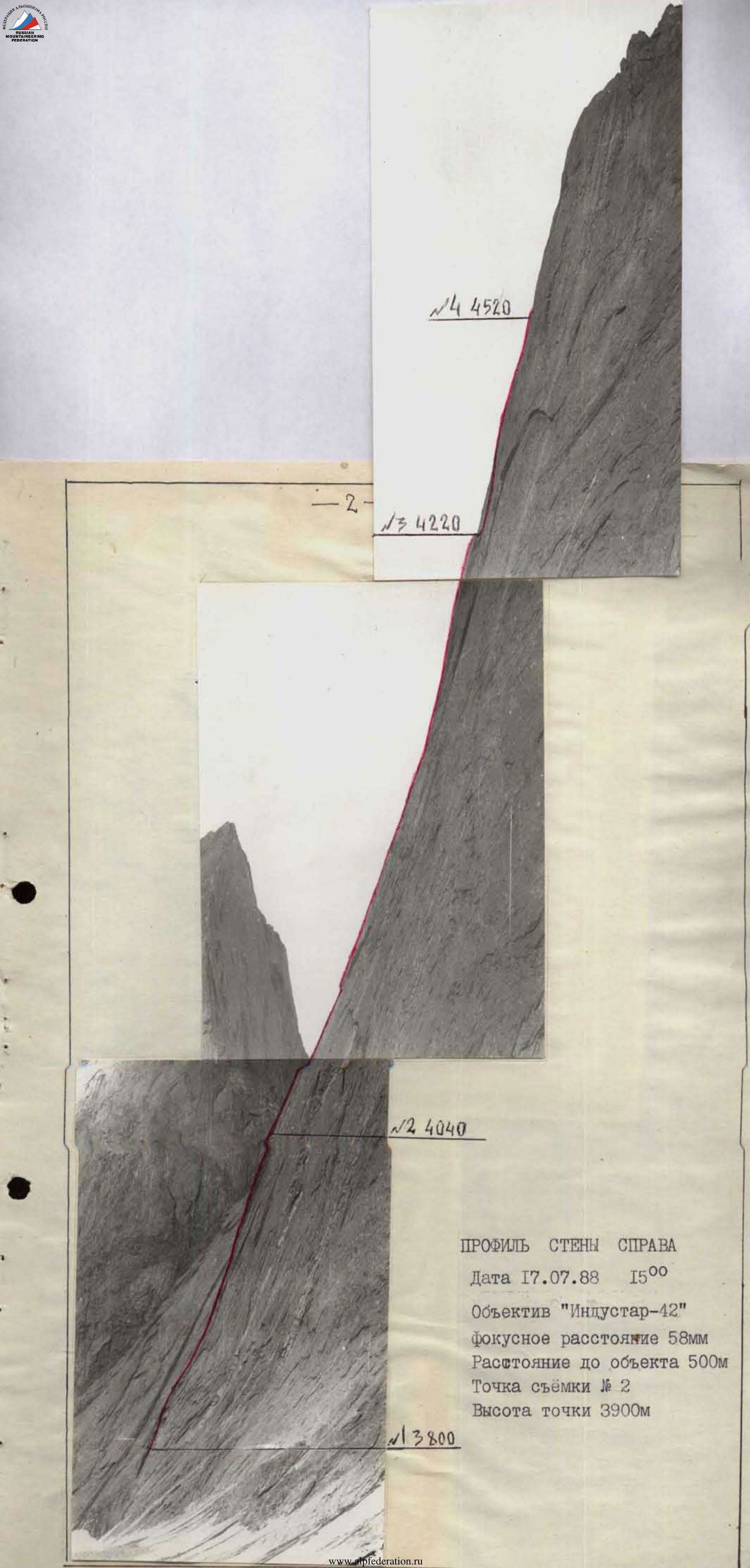
Right wall profile
Date: July 17, 1988. Time: 15:00. Lens: "Industar-42". Focal length: 58 mm. Distance to object: 500 m. Shooting point: # 2. Point height: 3900 m.
The purpose of reconnaissance exits and observations:
- Clarifying rockfall hazard of the wall at different times of day;
- Visual study of route sections;
- Clarifying overnight stay locations on and below the wall.
Table of food and fuel products
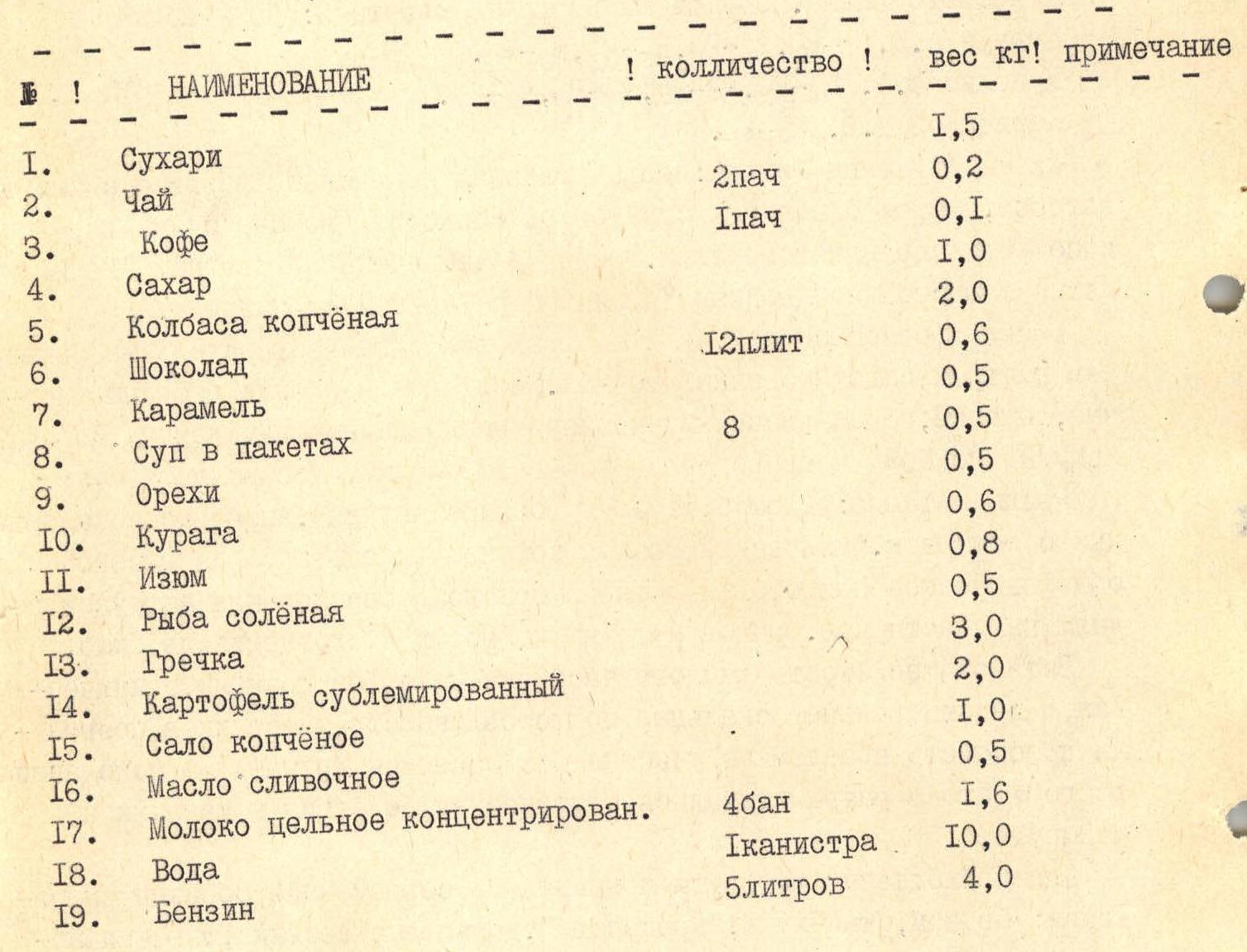
| Name | Quantity | Weight (kg) |
|---|---|---|
| 1. Crackers | 1.5 | |
| 2. Tea | 2 packs | 0.2 |
| 3. Coffee | 1 pack | 0.1 |
| 4. Sugar | 1.0 | |
| 5. Smoked sausage | 2.0 | |
| 6. Chocolate | 12 bars | 0.6 |
| 7. Caramel | 0.5 | |
| 8. Soup in packets | 8 | 0.5 |
| 9. Nuts | 0.5 | |
| 10. Dried apricots | 0.6 | |
| 11. Raisins | 0.8 | |
| 12. Salted fish | 0.5 | |
| 13. Buckwheat | 3.0 | |
| 14. Freeze-dried potatoes | 2.0 | |
| 15. Smoked lard | 1.0 | |
| 16. Butter | 0.5 | |
| 17. Whole condensed milk | 4 cans | 1.6 |
| 18. Water | 1 canister | 10.0 |
| 19. Gasoline | 5 liters | 4.0 |
Total: 31 kg. Total weight of backpacks when exiting the route — 76 kg.
Technical photograph of the route. Date: July 24, 1988. Shooting time: 19:00. Lens type: "Kodak" — 200 mm. Point number on the area scheme: 1. Distance: 3 km. Shooting point height: 3700 m.
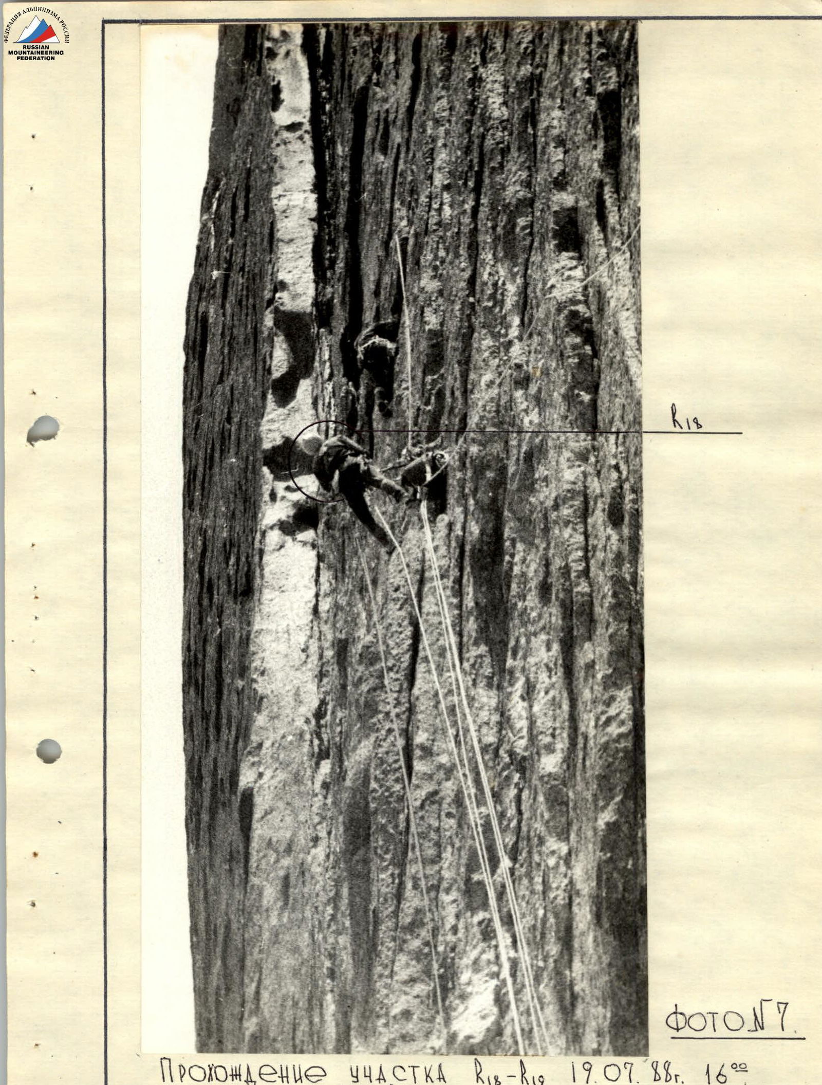
Photo # 7. Passage of section R18–R19. July 19, 1988, 16:00. Shooting point: R17.
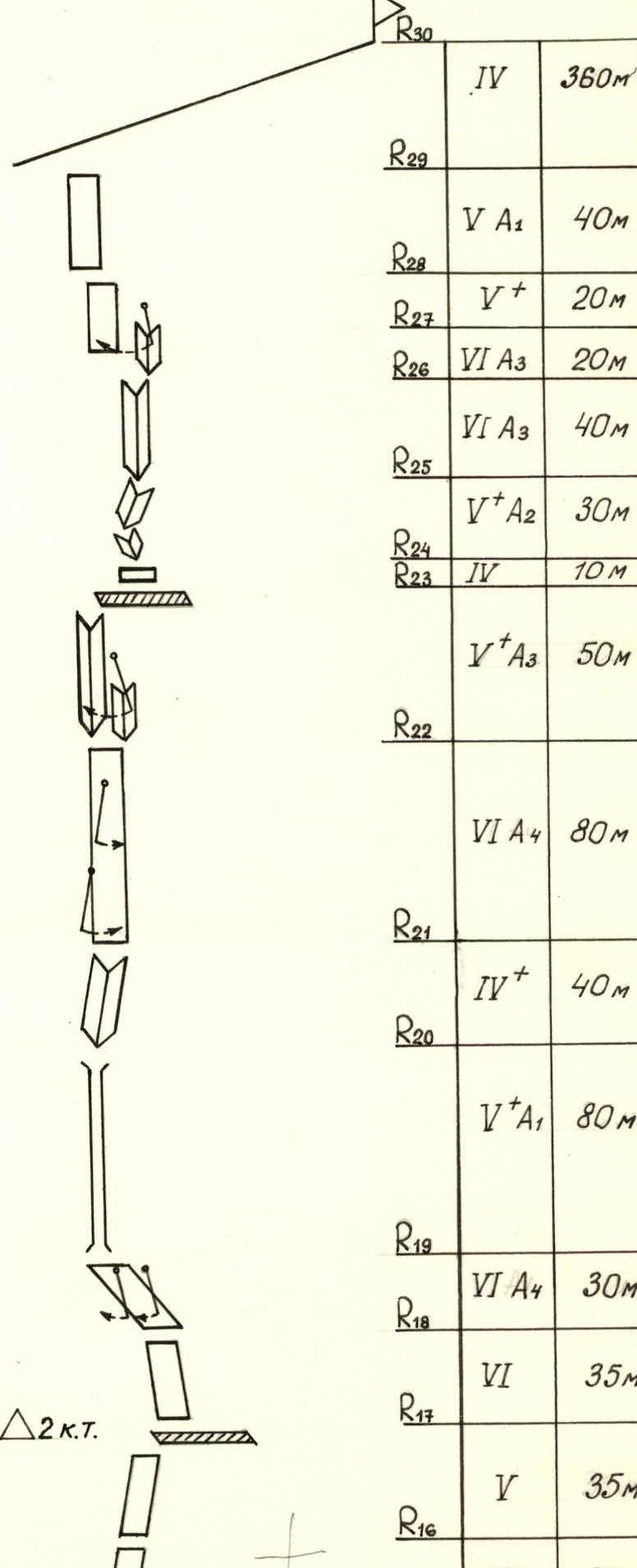
| Section | Rock | Chocks | Bolted | Sky hooks | Cat. sl. | Length (m) | Steepness (°) |
|---|---|---|---|---|---|---|---|
| R0 | |||||||
| R1 | VI А3 | 40 | 80 | ||||
| R2 | 3 | 5 | 5 | VI А4 | 40 | 90 | |
| R3 | 10 | 20 | 17 | 1 | VI А4 | 20 | 80 |
| R4 | 1 | 14 | 12 | 1 | VI А4 | 20 | 80 |
| R5 | 3 | 5 | VI А3 | 40 | 80 | ||
| R6 | 11 | 4 | 0 | 0 | V А1 | 30 | 70 |
| R7 | 5 | 6 | 5 | IV+ | 60 | 60 | |
| R8 | 7 | 2 | 1 | 2 | VI А2 | 40 | 80 |
| R9 | 4 | 4 | 1 | IV+ | 50 | 60 | |
| R10 | 4 | 4 | 1 | V | 50 | 70 | |
| R11 | 2 | 2 | IV | 35 | 60 | ||
| R12 | 3 | 4 | V | 35 | 70 | ||
| R13 | 5 | 5 | 3 | V+ А2 | 40 | 70 | |
| R14 | 0 | 1 | V+ А1 | 20 | 70 | ||
| R15 | 4 | 2 | 10 | 9 | VI А4 | 60 | 80 |
| R16 | 6 | 1 | VI | 30 | 80 | ||
| R17 | 2 | 5 | 2 | V | 35 | 75 | |
| R18 | 6 | 2 | 1 | 9 | VI | 35 | 80 |
| R19 | 2 | 14 | VI А4 | 30 | 85 | ||
| R20 | 10 | 14 | 2 | 3 | V+ А1 | 80 | 85 |
| R21 | 4 | 4 | IV+ | 40 | 65 | ||
| R22 | 25 | 8 | 7 | 6 | VI А4 | 80 | 85 |
| R23 | 10 | 3 | V А3 | 50 | 80 | ||
| R24 | 14 | 6 | IV | 10 | 55 | ||
| R25 | 1 | 10 | 5 | V+ А2 | 30 | 75 | |
| R26 | 4 | 12 | VI А3 | 40 | 80 | ||
| R27 | 2 | 17 | VI А3 | 20 | 80 | ||
| R28 | 4 | 3 | V+ | 20 | 75 | ||
| R29 | 1 | 8 | V А1 | 40 | 70 | ||
| R30 | 10 | 10 | IV | 360 |
Route description by sections
R0–R1 — monolithic wall with a small number of holds.
R1–R5 — heavily destroyed, hanging inner corner consisting of large-block slabs. Climbing is mainly on artificial terrain (ITO). Rockfall hazard!
R5 — overnight stay: two shelves, one for three people, one for one, two in hammocks. Overnight stay is safe.
R5–R6 — wall, ends with a cornice (overhang — 1.5 m) ITO.
R6–R11 — monolithic wall with a small number of holds and cracks for organizing belay. At belay points — bolted pitons. On section R2–R9, a pendulum was used, which made it possible to find cracks for chocks.
R11 — overnight stay: shelf for 6–8 people lying down.
R11–R17 — monolithic wall with a small number of holds, there is a cornice (overhang — 0.5 m) — ITO. For passing the section, sky hooks were used, for belay — bolted pitons. On section R2–R9, a pendulum was applied.
R17 — overnight stay: shelf for 6 people.
R17–R19 — steep wall, leading to a chimney. Climbed on sky hooks, bolted pitons. Pendulums were used to minimize the number of bolted pitons and climb on chocks.
R19–R20 — steep chimney, mainly free climbing.
R21–R22 — steep wall, used sky hooks, ITO. Two pendulums were used to transition from "mirrors" to relief.
R22–R23 — two inner corners, transition from one to another — pendulum. Climbing is mainly ITO.
R23 — overnight stay: sitting on different shelves.
R24–R25 — series of inner corners with seeping ice, climbing on chocks ITO. Made a pendulum — cracks ran out, exited the corner onto the wall.
R26–R30 — ridge leading to the summit.