I. Traverse Class.
- Northern spurs of the Turkestan Range, Karavshin valley.
- Traverse of peaks: 4810 m (ascent via the left part of the NW wall, first ascent, approximately 6B cat. diff.) — 4507 m (1000th anniversary of Baptism of Rus) — 4521 m (Kotin Peak) — 4000 m (Dukhtarak Peak) — 3800 m (Dukhtarcha Peak).
- First ascent, approximately 6B cat. diff.
- Average height of peaks on the traverse — 4320 m.
Average height of cols between peaks on the traverse — 4000 m. Traverse length — approximately 8500 m. Length of sections with 5–6 cat. diff., not including rappelling — 2400 m. Rappelling down walls with 5–6 cat. diff. — 2240 m.
- Pitons driven:
| Rock | Bolts | Nuts | Skyhook holes |
|---|---|---|---|
| 238+1X | 32+3X | 229 | 75 |
| 52+1X | 5 | 48 |
- Team's climbing hours on the traverse — 102 h.
- Overnights 1st, 2nd, 4th, 5th — sitting on snow ledges; 3rd, 6th, 7th — lying on ledges.
- Team Leader: I Viktor Igolkin — Master of Sports Team Members: Vladimir Lutsenko — Candidate for Master of Sports Sergey Skorokhodov — Candidate for Master of Sports Sergey Kraitor — Candidate for Master of Sports Veniamin Zhmaev — Candidate for Master of Sports Sergey Khromov — Candidate for Master of Sports
- Coach: Viktor Igolkin — Master of Sports of the USSR, International Class Climbing
- Preparation: July 6–8, 1990.
Departure for the route: July 13, 1990. Reached the summit: 4810 m — July 18, 1990. 4507 m — July 19, 1990. 4521 m, 4000 m, 3800 m — July 20, 1990. Returned to base camp from the traverse — July 20, 1990.
- Organisation:
- Climbing Authority
- AUSB "Varzob"
- MGGI Climbing Club

Photo 1. Photograph of the traverse from the Northeast. Taken from a helicopter on July 5, 1990. Distance — 2.5 km. Altitude — 3800 m. Camera "Zenit"-E.
Tactical Actions of the Team
The team's tactical plan was devised such that after two days of preparation, they would depart for the 1st overnight on the third day. This was planned to take 28 climbing hours. However, the weather made adjustments necessary. On the first day, July 6, 1990, rain literally "washed away" the Lutsenko-Skorokhodov rope team from the wall, allowing them to work for only 4 hours. On July 7, 1990, the Kraitor-Khromov rope team descended due to rain at 16:00, having worked on the wall for 6 hours (R4–R8). On July 8, 1990, the Lutsenko-Zhmaev rope team started the route in the rain but managed to complete only one rope length (R8–R9) on artificial terrain. The rain continued, turning to snow on the night of July 9, 1990, which fell for three days, turning the ascent into a winter climb.
Only on July 12, 1990, after lunch, the Kraitor-Skorokhodov rope team was able to start the route; water was cascading down the wall as the snow melted. The team completed two rope lengths (R9–R11). On July 13, 1990, the Khromov-Zhmaev rope team completed two rope lengths to the overnight stop (R11–R13) and, without stopping for the night, processed three more rope lengths above (R13–R16). Thus, the team reached R0–R13 in 25 climbing hours, aligning with the tactical plan.
It snowed again, preventing full work on July 14, 1990. The Lutsenko-Igolkin rope team could only start the route at 16:00, completing section R16–R17. On July 15, 1990, the Kraitor-Skorokhodov rope team reached the overnight stop ("chest") at 15:00 (R17–R20). A light snow began to fall. By 18:00, they processed another rope length (R20–R21).
On July 16, 1990, the Lutsenko-Skorokhodov rope team, having completed section R21–R24, stopped due to heavy snow. After the snow, rain started, intensifying the melting of snow. The team stood under waterfalls for 4 hours, trying to shelter from the incessant water flows. A thunderstorm passed, and by evening, it started to freeze; the ropes iced up. The rope team moved forward on the iced rocks on artificial terrain and reached the overnight stop at 21:00 (R24–R26). The team arrived already in the dark.
On July 17, 1990, the Khromov-Zhmaev rope team, after bad weather, moved on iced rocks to the next overnight stop (R26–R29).
On July 18, 1990, the Igolkin-Lutsenko rope team, having worked four rope lengths, reached the ridge and ascended to the summit at 13:00 via the snowy ridge. They immediately began descending and reached the col by 18:00 (R34–R35). After ascending to the Intermediate Peak (4350 m, R35–R36), the team continued descending (R36–R38).
On July 19, 1990, the Igolkin-Lutsenko rope team, having descended 80 m, traversed the slope (R37–R41). At 14:00, they began ascending Peak 4507 m. The 5B cat. diff. route was completed in 6 hours (R41–R49). They reached the summit at 20:00. Continuing along the ridge, they stopped for the night at 21:00.
On July 20, 1990, at 10:00, they descended to the col between 4507 m and 4512 m (R49–R51). At 11:00, they were at the start of the route on the southern ridge to Peak 4512 m (Kotin Peak, R51–R52). They ascended to the summit at 13:00 (R52–R58). They descended to the col between 4512 m and 4000 m (Dukhtarak Peak) by 16:20 (R58–R59).
On July 20, 1990, they ascended Dukhtarak Peak at 18:00 (R59–R62). At 21:00, they were on the 3800 m peak (Dukhtarcha), after which they descended to base camp.
Thus, the traverse took 102 climbing hours (according to the tactical plan — 104 climbing hours).
The team's movement was organized to ensure each participant worked as both the first and last on the rope, creating an even workload. The team used the full arsenal of modern technical means. Safety was ensured by choosing the direction of movement, working on a double rope, one of which was "Edelrid" UIAA certified.
Overnights 1st, 2nd, 4th, 5th — sitting on snow ledges, 3rd, 6th, 7th — lying on ledges. Nutrition was twice a day (morning and evening) using high-calorie individual rations and a drink from flasks during the day. Water was melted from snow. To quickly prepare meals and conserve fuel, food was cooked in an autoclave.
There were no falls or injuries among team members. Communication with base camp and the rescue team was maintained through two observers stationed below the route with an RPT radio set. Observations were made through a 12x binocular.
The successful completion of the traverse was facilitated by the following factors:
- thorough reconnaissance and detailed study of the route;
- experience of climbing in this area;
- good material base of the expedition (food, equipment, medicine, rescue team);
- effective preparation of participants for ascents on routes of 5B and 6 cat. diff.;
- regular radio communication with base camp.
Description of the Route by Sections
R0–R1 — the route starts from the hanging bivouac via an internal corner. R1–R3 — monolithic slab with cracks and flakes, passed by free climbing. R3–R4 — crack, then a small cornice, insurance point on bolted pitons, skyhooks are used. R4–R7 — wall is wet, difficult climbing on monolithic slabs. R7–R9 — two small cornices in a row, extensive use of artificial terrain. R9–R13 — "bird" cornice is passed on the right side, then along a monolithic slab. Exit to the overnight stop via an internal corner. R13–R15 — traverse rightward by climbing under a large cornice, pendulum technique is widely used to overcome monolithic slabs. R15–R16 — passage of the cornice on artificial terrain, climbing is difficult. R16–R20 — monolithic slab with minimal holds, extremely difficult climbing, skyhooks and screwed-in bolted pitons are used. Exit to the "chest" overnight stop via a simple internal corner. R20–R22 — traverse leftward to a chimney using pendulum technique, wall is wet, climbing is difficult. R22–R24 — chimney is passed in a stem, chimney is icy after bad weather. R24–R26 — after bad weather, rocks are icy, passed on artificial terrain, series of internal corners and cracks, exit to the overnight stop. R26–R28 — monolithic wall, pendulum traverse rightward to a crack, due to bad weather, artificial terrain is used. R28–R29 — internal corner, wet, passed on artificial terrain, exit to the overnight stop. R29–R33 — series of internal corners, leading to the ridge, rocks are covered in rime ice. R33–R34 — along the ridge to the summit of 4810 m, climbing on snowy and icy rocks. R34–R35 — descent by rappelling down the North Ridge (5B cat. diff. combined route), monolithic slabs. R35–R. Intermediate Peak, rocks are broken, flakes. R36–R37 — descent by rappelling down a steep snow-ice couloir to the overnight stop. R37–R41 — traverse of the slope toward the col between Peak 4507 m and Intermediate Peak, diverse relief, approach under the start of the route on Peak 4507 m (5B cat. diff.). R41–R43 — ascent on monolithic slabs, then a small traverse. R43–R46 — series of smooth internal corners, passed by free climbing. R46–R49 — ridge with steep drops, monolithic slabs covered in moss. Exit to the summit of 4507 m. R49–R50 — traverse of the ridge, climbing is more difficult on smooth slabs. Overnight stop. R50–R51 — descent by rappelling down monolithic slabs. R51–R52 — traverse of the slope toward Peak 4521 m (Kotin Peak), diverse relief, climbing is not difficult. R52–R54 — ascent via an internal corner, then traverse leftward. R54–R56 — smooth slabs, climbing is difficult, exit to the ridge. R56–R58 — broken ridge, internal corners alternate with short steep walls. Exit to the summit of 4521 m. R58–R59 — descent by rappelling down the North Ridge to the col, ridge is heavily broken. R59–R62 — broken ridge, ascent to the summit of 4000 m (Dukhtarak Peak). R62–R63 — descent by rappelling, then climbing to the col between Peaks 4000 m and 3800 m. R63–R64 — simple broken ridge, ascent to the summit of 3800 m (Dukhtarcha Peak). R64–R65 — descent by climbing down a simple ridge to the col, then into the Karasu River valley.
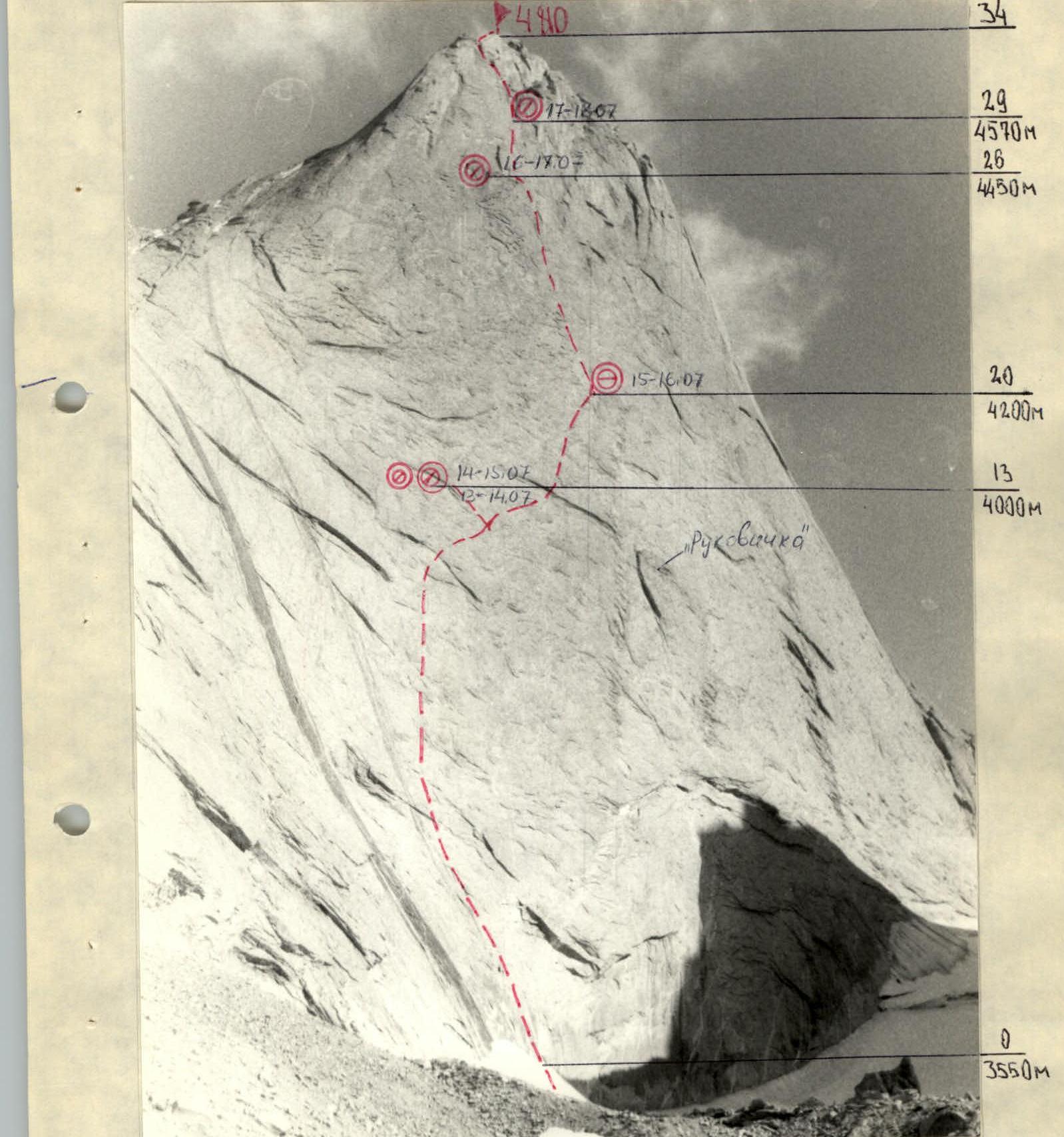
Photo 3. View of Peak 4810 m from the approach to the route. Taken on July 5, 1990, distance 600 m. Altitude 3300 m. Lens "Mir-1V".

Photo 4. Descent from Peak 4810 m down the North Ridge (5B cat. diff. combined route, Sitnik, 1986). Taken on July 22, 1990, distance 2.5 km. Altitude — 3200 m. Focal length — 200 mm. On the left side of the photograph is Intermediate Peak 4350 m, ascent to it section R35–R36, 120 m, III–IV cat. diff., 50°.
| Rock | Nuts | Bolts | Skyhooks | Section | Cat. diff. | Length, m | Steepness, ° |
|---|---|---|---|---|---|---|---|
| - | 2 | - | - | R48–R49 | 4 | 40 | 60 |
| 6 | 10 | - | - | R47–R48 | 4 | 120 | 40 |
| 19 | 1 | 21 | 2 | R46–R47 | 4–5 | 400 | 55–65 |
| 3 | 2 | 4 | 3 | R45–R46 | 5 | 80 | 80 |
| 2 | 1 | 4 | 3 | R44–R45 | 5 | 80 | 70 |
| 3 | 3 | 1 | - | R43–R44 | 5 | 40 | 60 |
| - | 4 | - | - | R42–R43 | 4 | 80 | - |
| 3 | 4 | - | - | R41–R42 | 5 | 80 | 70 |
| 3 | 1 | 5 | 2 | R40–R41 | 5 | 60 | 70 |
| 3 | 2 | - | - | R39–R40 | 4 | 60 | 50 |
| 3 | 3 | - | - | R38–R39 | 5 | 40 | 70 |
Note: for section R42–R43, a traverse is indicated.
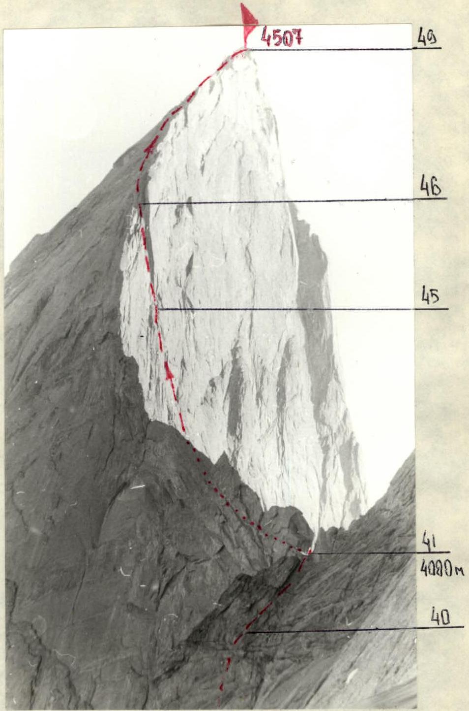
Photo 5. View of Peak 4507 m (1000th anniversary of Baptism of Rus) from the route on the NW wall to Peak 4810 m. Distance 600 m. Camera "Smena-Symbol". Altitude 4200 m.
Photo 6. View of Peak 4507 m from the East. Taken from a helicopter on July 5, 1990. Distance 600 m. Altitude 4000 m. Camera "Smena-Symbol".
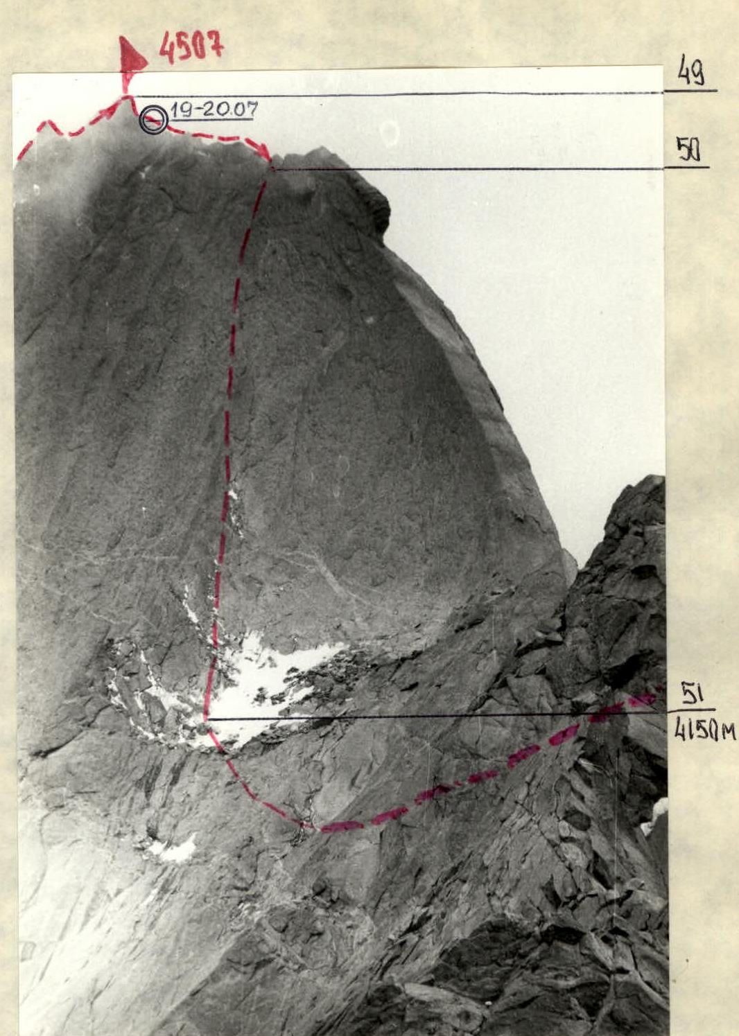
Photo 7. Descent from Peak 4507 m down the North Ridge. Taken from the slope of Peak 4521 m (Kotin Peak). Distance 600 m. Altitude 4200 m. Camera "Smena-Symbol".
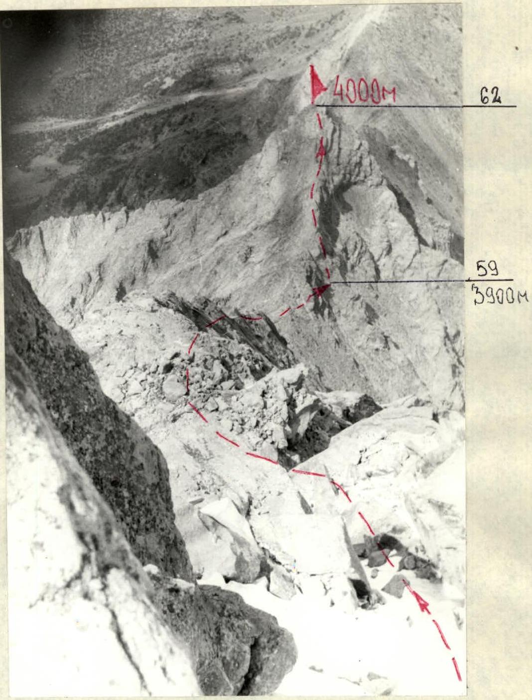
Photo 13. View of Peak 4000 m (Dukhtarak) from Peak 4521 m (Kotin Peak). Camera "Smena-Symbol". July 20, 1990.
After descending from Peak 4521 m (Kotin Peak):
- ascent to Peak 4000 m (Dukhtarak Peak)
- traverse of Peak 4000 m from South to North — first ascent, approximately 3B cat. diff.
Ascent to the col between Peaks 4521 m and 4000 m from the Karasu or Aksu valley via rocks, approximately 2A cat. diff., length 1000 m, steepness 40–45° (height difference 750 m).
After descending from Peak 4000 m, ascent to Peak 3800 m (Dukhtarcha Peak).
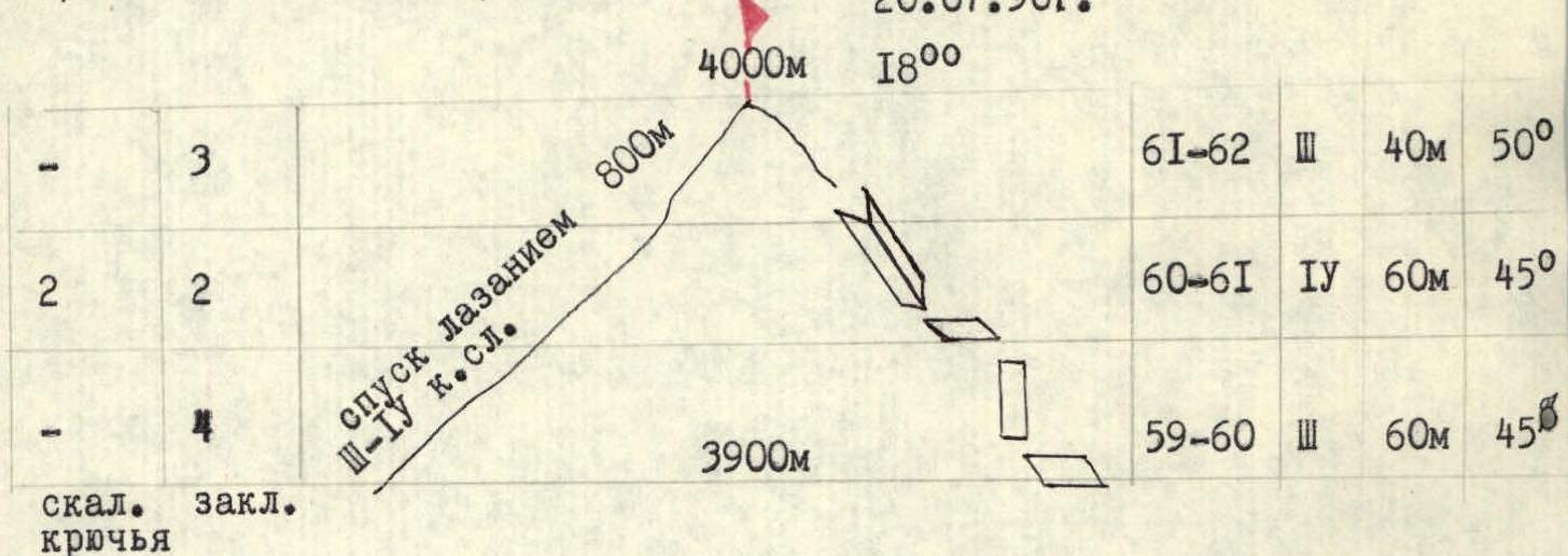
| Cat. diff. | Length, m | Steepness, ° | |
|---|---|---|---|
| R61–R62 | 3 | 40 | 50 |
| R60–R61 | 4 | 60 | 45 |
| R59–R60 | 3 | 60 | 45 |

Traverse of Peak 3800 m from South to North — first ascent, approximately 2A cat. diff.